| 
| |
|
|
History of King's Highway 102 (#2):
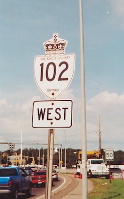
King's Highway 102 is a relatively short but important arterial highway which links Thunder Bay with Highway 11 & Highway 17 at Sistonens Corners. The highway
passes through an almost exclusively rural area along its route. The only major town located along the highway is Thunder Bay, which is situated at the eastern end of
the route. The highway was first established in 1971, when Highway 11A &
Highway 17A was renumbered as Highway 102. The highway forms a cut-off route for Trans-Canada
Highway traffic, by allowing motorists to bypass Kakabeka Falls and the majority of Thunder Bay. The route of Highway 102 was realigned extensively during highway
improvement projects carried out during the 1970s. Originally, the assumed section of Highway 102 began at the Thunder Bay Expressway (Highway 11 & Highway 17) and continued west to Sistonens Corners. The section of Highway 102 lying between Highway 11B & Highway 17B in Downtown Thunder Bay and the Thunder Bay Expressway was not an assumed section of the King's Highway and was thus under municipal jurisdiction. As the City of Thunder Bay expanded in the 1970s and 1980s, sections of Highway 102 were transferred to the municipality. A short section of Highway 102 lying between Fassina Street and Strand Avenue, located just west of the Thunder Bay Expressway (Highway 11 & Highway 17), was transferred from the province to the City of Thunder Bay, effective March 16, 1981. Another section of Highway 102 from Fassina Street to Skyline Avenue was transferred to the City of Thunder Bay on October 27, 1983. On January 1, 1998, a 5.3 km section of Highway 102 between Skyline Avenue and the Highway 589 Junction was transferred from the province to the City of Thunder Bay. This downloaded section of Highway 102 is now officially known as Dawson Road, although it was still signed continuously as Highway 102 from Sistonen's Corners to the Thunder Bay Expressway as of late 2015. Highway 102 is a two-lane highway for most its length between Thunder Bay and Sistonens Corners. Passing lanes appear quite frequently along this highway. The highway provides a scenic alternate route for motorists travelling across Canada who do not wish to stay on Highway 11 & Highway 17 through Thunder Bay. The route via Highway 102 is over 17 km shorter than the route offered via Highway 11 & Highway 17. There are no services along Highway 102, other than in Thunder Bay and at Sistonens Corners. The speed limit on Highway 102 is 90 km/h (55 mph), unless posted otherwise. Please visit the Highway 102 Mileage Chart page for a list of mileage reference points along Highway 102. 
 |
|---|
Additional Information About King's Highway 102 (#2):
King's Highway 102 - Route Information (At Scott Steeves' website: asphaltplanet.ca)
King's Highway 102 - A Virtual Tour (At Scott Steeves' website: asphaltplanet.ca) |
|---|
Links to Adjacent King's Highway Pages: 

Website contents, photos & text © 2002-2024, Cameron
Bevers (Webmaster) - All Rights Reserved / Contact Me |
|---|