| 
| |
|
|
History of King's Highway 11B (Tri-Town):
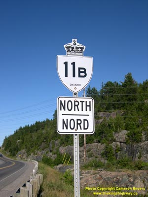
The Highway 11B Business Route through Cobalt, Haileybury and New Liskeard was created in 1963, when the Tri-Town Bypass was opened to traffic. The old alignment of
Highway 11 through the three downtown areas was renumbered as Highway 11B, while the Highway 11 designation was assigned to the new Tri-Town Bypass. The Tri-Town
business route was 26.1 km in length, making it the second-longest business route ever designated in Ontario. The highway followed Miller Avenue, Cobalt Street,
Grandview Avenue, Silver Street and Lang Street through Cobalt. Through North Cobalt and Haileybury, Highway 11B followed King Street, Rorke Avenue, Main Street,
Ferguson Avenue and Lakeshore Road. Highway 11B followed Lakeshore Road, Paget Street, Whitewood Avenue and Armstrong Street through New Liskeard. The length of Highway 11B was drastically reduced by the highway downloading in 1997-1998. The provincially-owned section of Highway 11B from the north limits of New Liskeard to the Highway 65 East Junction was transferred from the province to the Town of New Liskeard on March 31, 1997. Two sections of Highway 11B on the north and south approaches to Haileybury totalling 9.5 km in length were transferred from the province to the Town of Haileybury on March 31, 1997. The sections of Highway 11B running through the incorporated town limits of Cobalt, Haileybury and New Liskeard were eventually stripped of their King's Highway signs, as the Municipal Connecting Links for these non-assumed sections of Highway 11B were revoked. Only two short sections of Highway 11B were retained in the provincial highway system. The first section of Highway 11B runs from the south Highway 11 Junction to the western Cobalt limits. Highway 11B then resumes on the northern side of Cobalt and ends at the south limits of the newly-formed City of Temiskaming Shores. The northernmost 800 metres of Highway 11B at Dymond was also retained in the provincial highway system, but this section was renumbered as Highway 65 during a highway renumbering project which took place in May 2003. The surviving sections of Highway 11B total 7.1 km in length. 

 |
|---|
Links to Adjacent King's Highway Pages: 


Website contents, photos & text © 2002-2026, Cameron
Bevers (Webmaster) - All Rights Reserved / Contact Me
|
|---|