| 
| |
|
|
History of King's Highway 136:
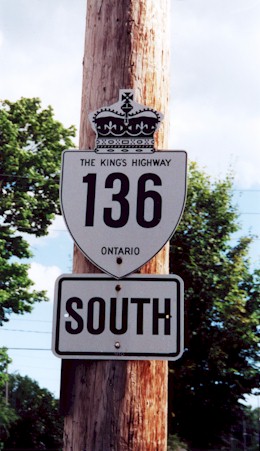
King's Highway 136 was a minor collector highway that connected Highway 24 near Cataract with Highway 9 in Orangeville. Highway 136 was created during a route
renumbering which took place in 1961. Originally, Highway 24 followed the route of Highway 136 between
Cataract and Orangeville, via Alton. Another short highway, known as Highway 51, connected Highway 24 near
Cataract to Highway 10 in Caledon (See Map). During the 1961 route renumbering,
Highway 24 assumed the route of Highway 51 from Cataract to Caledon. The old route of Highway 24 from Cataract to Orangeville, via Alton, was re-designated as
Highway 136 (See Map). The highway was paved from Cataract to Alton in 1963, and
from Alton to Orangeville in 1965. The section of Highway 136 lying within the Town of Orangeville was considered to be a Municipal Connecting Link. Highway 136 was formally decommissioned as a King's Highway on March 31, 1997, when the highway was turned over to the Regional Municipality of Peel. The Municipal Connecting Link status of Highway 136 within the Town of Orangeville was also repealed. Highway 136 is now known as Peel Regional Road 136, although it is still commonly referred to as "Highway 136" by motorists. Within Orangeville, former Highway 136 is known as Townline and John Street. Highway 136 is a two-lane road for its entire length. Apart from Orangeville, Alton is the only major community along Highway 136. Services are available in Alton and Orangeville. The speed limit on Highway 136 is 80 km/h (50 mph), unless posted otherwise. 
 |
|---|
Links to Adjacent King's Highway Pages: 

Website contents, photos & text © 2002-2024, Cameron
Bevers (Webmaster) - All Rights Reserved / Contact Me |
|---|