| 
| |
|
|
History of King's Highway 16:
King's Highway 16 was one of Eastern Ontario's most important King's Highways up until the late 1990s, when it almost disappeared completely as a result of the
completion of Highway 416 between Highway 401 and Ottawa. Only one small section of Highway 16 still exists today within the United Counties of Leeds & Grenville
in the Johnstown area. It is presently only 3.4 km in length, and is now one of the shortest King's Highways in Ontario's provincial highway system. However,
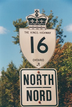
Highway 16 once had much grander days, including holding the honour of being one of Ontario's very first Provincial Highways. The history of Highway 16 dates back to the closing year of World War I, when the provincial Department of Public Highways of Ontario (DPHO) was still very much in its infancy. Following the DPHO's successful acquisition of the Kingston Road between the Rouge River and Port Hope as a new Provincial Highway in 1917, the Department sought to acquire other strategic road links throughout Ontario as Provincial Highways. In 1918, the DPHO assumed jurisdiction over the road between Prescott and Ottawa as a new Provincial Highway. This new highway connected Ottawa to the Kingston-Montreal Road at Prescott. The Kingston-Montreal Road, which later became Highway 2, was the main east-west road across the eastern part of Ontario. At the time, the Kingston-Montreal Road was also the only practical route available for traffic travelling between Ottawa and Toronto. The Ottawa-Prescott Road was designated as a new Provincial Highway by virtue of an Order-in-Council dated June 7, 1918. Preliminary Route Plans were prepared dated July 10, 1918, which showed the proposed route for the new Provincial Highway within the County of Carleton and the County of Grenville. The new highway began at the eastern limits of the Town of Prescott and continued easterly to Johnstown, where the Provincial Highway turned north towards Ottawa via Spencerville, Kemptville, North Gower and Manotick. The Ottawa-Prescott Road was assumed by the DPHO as a Provincial Highway, effective August 15, 1918. Initially, the highway came to an end in Nepean Township near the present-day intersection of Prince of Wales Drive and Fisher Avenue (Ottawa Road 69). The balance of the road leading north from that point to Ottawa was assumed by the DPHO, effective May 23, 1919. This section of the Ottawa-Prescott Road was previously a toll road which was acquired by the DPHO as an extension of the Provincial Highway. Following the extension of 1919, provincial jurisdiction over the highway came to an end at the Ottawa City Limits, which at that time were located at the Canadian Pacific Railway crossing at Dow's Lake, just south of Preston Street. The newly-established Ottawa-Prescott Provincial Highway was approximately 59 miles (95 km) in length (See Map). At first, the highway did not have a route number. When a highway route numbering system was employed across the province in 1925, the Ottawa-Prescott Highway from Johnstown northerly was designated as Provincial Highway 16. The section of the Ottawa-Prescott Highway between Prescott and Johnstown was numbered as part of Provincial Highway 2. Some historical sources suggest that Highway 2 & Highway 16 may have shared an overlapped route between Prescott and Johnstown up until 1947, although this overlapped route has not yet been confirmed. Provincial Highway 16 was re-designated as King's Highway 16 in 1930. Highway 16 was in a very poor state of repair at the time the highway was first assumed in 1918-1919. Most of the road had an unimproved earth surface at first, which made early travel on the highway very difficult. Long sections of the highway were nearly impassable in wet weather. Between 1918 and 1921, a considerable amount of grading work was done along the highway to provide proper roadside drainage. A crushed stone surface was provided along the highway by the early 1920s, in order to allow all-weather travel. Nearly six miles of macadam pavement was laid in the vicinity of Hog's Back in 1921. Four miles of asphaltic concrete pavement was laid along Highway 16 from Ottawa southerly in 1922. In 1925, concrete pavement was laid from the Rideau River Bridge southerly through Kemptville, along with some gaps in the pavement near Manotick and through North Gower. About 8 miles of concrete pavement was laid between the Rideau River Bridge and North Gower in 1926, which completed a continuous pavement along Highway 16 between Kemptville and Ottawa. From the south end, concrete pavement was laid from Prescott easterly to Johnstown in 1925 and from Johnstown northerly to Spencerville in 1928. The last gravel section along Highway 16 between Spencerville and Kemptville was paved over in 1929, when 12 miles of mixed macadam pavement was laid between the two villages. This final paving contract also completed a paved highway link between Ottawa and Toronto. As originally established in 1918-1919, the DPHO did not assume responsibility for the sections of Highway 16 lying within the Village of Kemptville or the City of Ottawa. These sections of Highway 16 were considered non-assumed sections of the highway which remained under municipal jurisdiction. Provincial jurisdiction over Highway 16 was extended through parts of Kemptville during the second half of the 1920s. A Preliminary Route Plan was prepared dated February 7, 1925, which showed the proposed assumption of streets within the incorporated limits of the Village of Kemptville as part of the Provincial Highway. On February 25, 1925, the DPHO assumed jurisdiction over West Street and portions of North Rideau Street, Clothier Street and the portion of Prescott Street lying south of Van Buren Street as part of Highway 16. An additional section of Prescott Street was assumed under a Preliminary Route Plan dated November 7, 1925. The section of Prescott Street between Van Buren Street and Ash Street was assumed by the DPHO as part of Highway 16, effective November 25, 1925. To facilitate the proposed replacement of the Kemptville Creek Bridge, a final section of Prescott Street was assumed under a Preliminary Route Plan dated March 10, 1927. The section of Prescott Street between Clothier Street and the southern end of the Kemptville Creek Bridge was assumed by the DPHO as part of Highway 16, effective March 30, 1927. By early 1927, the DPHO had acquired jurisdiction over the entire route of Highway 16 within the Village of Kemptville, with the exception of the short section of Prescott Street between Ash Street and the Kemptville Creek Bridge, which continued to remain under the jurisdiction of the village. Several changes were made to the route of Highway 16 in the ensuing decades. A short diversion was constructed at the north entrance to North Gower in 1921, in order to eliminate an awkward corner in the community and to provide a wider bridge over Stevens Creek. Originally, Highway 16 followed Craig Street (today's James Craig Street) and Worthington Street (today's Roger Stevens Drive) through North Gower. Jurisdiction over the old route of Highway 16 through North Gower was transferred to the Township of North Gower by an Order-in-Council dated December 7, 1921. Other short realignments took place between North Gower and the Manotick area during 1921, to eliminate sharp curves and other unnecessary turns in the highway's original 1918 route. The most notable realignment took place north of Manotick, where nearly 1 mile of the original route of Highway 16 was bypassed by a new diversion. The former route of Highway 16 followed portions of today's Barnsdale Road and Prince of Wales Drive. Jurisdiction over the old highway alignment was reverted to the Township of Nepean by an Order-in-Council dated December 7, 1921. A fairly significant realignment of the highway took place at Van Allens south of Kemptville in 1931. The former highway's route followed Porter Road and MacKenzie Road, which reverted back to the Townships of Oxford and Edwardsburgh, effective September 2, 1932. Construction began on a new high-level bridge across the Rideau River in 1936, which bypassed an old mid-19th Century swing bridge at Becketts Landing. The new bridge was completed and opened to traffic in 1937, after which time the old swing bridge was closed to traffic and removed. The old alignment of Highway 16 which led to both ends of the former swing bridge at Becketts Landing reverted back to municipal jurisdiction, effective June 7, 1938. As a result of the expansion of Ottawa's City Limits after World War II, jurisdiction over a section of Highway 16 was transferred from the province to the City of Ottawa. On April 17, 1950, the Department of Highways of Ontario (DHO) transferred jurisdiction of about 3 miles of Highway 16 to municipal control, from the vicinity of Fisher Avenue northerly to the former Ottawa City Limits at the railway crossing near Preston Street. This transferred section of Highway 16 along with the short connection to Highway 17 (Carling Avenue) via Preston Street was subsequently designated as a Municipal Connecting Link in 1958. The 1960s brought about more changes to Highway 16. A new Highway 16 Bypass was built around Manotick in the early 1960s. A Highway Designation Plan was prepared in April 1961, which showed the proposed diversion of Highway 16 around Manotick. The Manotick Bypass was designated as a King's Highway by an Order-in-Council, effective June 22, 1961. The bypass was subsequently designated as a Controlled-Access Highway by an Order-in-Council, effective October 20, 1961. The Manotick Bypass was completed and opened to traffic in November 1962, which greatly improved traffic flow along Highway 16. Jurisdiction over the old route of Highway 16 through Manotick via Century Road and Rideau Valley Drive reverted back to the Township of North Gower, effective August 24, 1963. The provincially-maintained sections of Highway 16 through Kemptville were transferred to the Village of Kemptville, effective April 28, 1961. The entire route of Highway 16 through Kemptville was subsequently designated as a Municipal Connecting Link. As originally established, Highway 16 followed West Street on the northern approach to Kemptville's village centre. Beginning in 1961, a new one-way street system was introduced through Kemptville which required northbound Highway 16 traffic to use West Street while southbound Highway 16 traffic was required to use North Rideau Street. This one-way street loop system connected to Prescott Street via Clothier Street. The one-way street system was discontinued once the Kemptville Bypass (Highway 16 New) was completed in the early 1970s. Several new routes for Highway 16 have been established over the years within the City of Ottawa. Originally, the route of Highway 16 followed Prince of Wales Drive into Ottawa, where the highway turned right onto Carling Avenue (Highway 17) at Preston Street. Highway 16 then followed Carling Avenue, Glebe Avenue and Bank Street into Downtown Ottawa, concurrently with Highway 17. The route of Highway 16 apparently came to an end at the intersection of Bank Street and Wellington Street in the city centre. A second new route debuted in 1940, which had Highway 16 continue east along Glebe Avenue from Bank Street to O'Connor Street, concurrently with Highway 15, Highway 17 & Highway 31. At O'Connor Street, all four highways briefly turned north then continued east towards the Rideau Canal via Linden Terrace. At Rideau Canal Drive (today's Queen Elizabeth Drive), all four highways turned left and continued north into Downtown Ottawa. The longer Highway 16 route via the Rideau Canal was most likely a city-established "scenic" route, as the DHO's post-1940 mileage logs still noted the northern terminus of Highway 16 as Ottawa, with no change in mileage reported (58.9 miles). Some post-1940 maps indicate that Highway 16 was signed continuously along the Glebe Avenue and Rideau Canal Drive route, while others indicate that Highway 16 ended at the intersection of Prince of Wales Drive (today's Preston Street) and Carling Avenue (Highway 17). Between 1940 and 1945, the Official Ontario Road Map shows the two routes of Highway 16 leading into Downtown Ottawa (See Map), but both routes was omitted from maps dated between 1946 and 1954. It is not clear if either the Bank Street or the Rideau Canal Drive routes were actually signed after 1946, but it is quite likely that the routes continued to be signed even though they were omitted from the Official Ontario Road Maps. In 1955, a new route was established for Highway 16 that had the highway turn directly onto Rideau Canal Drive from Prince of Wales Drive. According to the Official Ontario Road Maps from 1955 to 1959, Highway 16 followed Rideau Canal Drive continuously from Prince of Wales Drive into Downtown Ottawa, concurrently with Highway 15 & Highway 17 (See Map). Between Bank Street and Downtown Ottawa, these three highways were also signed concurrently with Highway 31. In 1960, all scenic routes of Highway 16 were eliminated and Highway 16 was truncated at Highway 17 (Carling Avenue) and Prince of Wales Drive (See Map). A new section of the Ottawa Queensway was completed and opened to traffic in 1964, which resulted in Highway 17 being rerouted off of Carling Avenue and onto the new freeway. As a result, Highway 16 was relocated from the northern end of Prince of Wales Drive onto a new route over the Rideau River. At Hog's Back, Highway 16 turned right off of Prince of Wales Drive and followed Heron Road easterly. Highway 16 came to an end at the Highway 31 Junction, located at the intersection of Heron Road and Bronson Avenue. This revised route of Highway 16 via Heron Road was designated as a Municipal Connecting Link in 1964. However, many road maps printed since that time, including the Official Ontario Road Maps issued between 1978 and 1997, show that Highway 16 turned north along Bronson Avenue from Heron Road and ran concurrently with Highway 31 up to the Ottawa Queensway (See Map). This concurrent route along Bronson Avenue is believed to be a city-established route, as the Ministry of Transportation's mileage logs issued between 1970 and 1997 indicate that Highway 16 did indeed end at Bronson Avenue and Heron Road. DHO mileage tables from the mid-1960s indicate that Highway 16's mileage had declined to 51.9 miles, due in part to the completion of a new bypass around Manotick as well as the decommissioning of the route of Highway 16 leading into Downtown Ottawa from the intersection of Bronson Avenue and Heron Road. By the 1990s, the length of Highway 16 had declined slightly to 78.1 km (48 1/2 miles), due to various highway realignments. In 1966, the DHO completed a major transportation planning study for Eastern Ontario. Among the study's recommendations was the need to build a new Controlled-Access Highway link between Ottawa and Highway 401, which was nearing completion through Eastern Ontario at that time. On November 10, 1967, the DHO announced that a new 400-Series Highway, to be known as Highway 416, would be built between Ottawa and Highway 401 near Prescott. The new Highway 416 would provide a more direct link between Ottawa and Highway 401 than the route offered by existing Highway 16. It was acknowledged that only two lanes were required to serve traffic volumes for the foreseeable future, so a decision was made to build the new highway as a "staged freeway". Under the plan, a new limited-access two-lane Highway 16 corridor was built on a brand new alignment which generally ran in close proximity to existing Highway 16. This new alignment bypassed all of the towns between Ottawa and Prescott. In the process, all local access to and from the new Highway 16 corridor would be prohibited. The new two-lane Highway 16 could easily be converted into a freeway at any time in the future by building a second roadway beside the existing highway. The first section of Highway 16 New to be designated was the Spencerville Bypass. The route of this proposed 3.7-mile Highway 16 Bypass was depicted on a Designation Plan prepared by the DHO dated July 13, 1967. The highway was designated by an Order-in-Council, effective August 3, 1967. A new Designation Plan was prepared dated November 13, 1968, for the entire route of Highway 16 New (future Highway 416) within Grenville County. The proposed 27-mile (44 km) route was designated by an Order-in-Council, effective January 2, 1969. A second Designation Plan was prepared dated November 25, 1968, for the route of Highway 16 New (future Highway 416) within Carleton County. Although this plan showed a proposed 19-mile (31 km) route of proposed highway, only the section of the route lying south of the Manotick Bypass was ultimately constructed as initially planned. This route was designated by an Order-in-Council, effective January 2, 1969. Work began on Highway 16 New in late 1967, when the first clearing contract was called for the Spencerville Bypass. This work was continued in 1968, with a construction contract to build a new 3 1/2 mile bypass around the eastern side of Spencerville. Two clearing contracts were also awarded for the Kemptville Bypass in 1968. Three more clearing and grading contracts were awarded in 1969 to construct Highway 16 New from just north of the Highway 401 Interchange at Johnstown northerly to the south end of the Spencerville Bypass and the southern leg of the Kemptville Bypass from existing Highway 16 to Highway 43. A contract was also tendered in 1969 for final paving of the Spencerville Bypass, which was completed and opened to traffic in 1970. By the end of the 1970 construction season, work was underway on 24 miles of Highway 16 New from Highway 401 northerly to Dilworth Road (Ottawa-Carleton Road 13) located just north of the Rideau River Bridge near Kemptville. Work tendered in 1970 included grading for Highway 16 New from Highway 43 northerly to Dilworth Road, reconfiguration of the Highway 401 & Highway 16 Interchange, final paving for Highway 16 New from Highway 401 northerly to the south end of the Spencerville Bypass and grading for Highway 16 New from the north end of the Spencerville Bypass northerly to the south end of the Kemptville Bypass. Two contracts were called in 1971 for the completion of final paving from Spencerville to the Highway 43 Junction. With the exception of the Spencerville Bypass which had been completed previously, the rest of Highway 16 New was completed from the Highway 401 Interchange northerly to the Highway 43 Junction near Kemptville in 1972. A contract for final paving was awarded for the north leg of the Kemptville Bypass from Highway 43 to Dilworth Road in 1973. This contract was completed in 1974, after which Highway 16 New was opened to traffic from the Highway 43 Junction to the existing route of Highway 16 at Dilworth Road located north of the Rideau River Bridge (See Map). Following the completion of Highway 16 New, the Ministry of Transportation and Communications (MTC) began to transfer jurisdiction over Old Highway 16 to the municipal tier. Jurisdiction over Old Highway 16 was transferred to the United Counties of Leeds & Grenville through Spencerville between the two County Road 21 Junctions and through Millars Corners between the two County Road 20 Junctions, effective October 1, 1973. The balance of Old Highway 16 from the Highway 401 Interchange northerly to the south end of the Kemptville Bypass was transferred from the province to the Municipal Township of Oxford-on-Rideau and Township of Edwardsburgh, effective October 5, 1973. In the Kemptville area, provincial jurisdiction over Old Highway 16 from the south end of the Kemptville Bypass to the county boundary at the Rideau River Bridge was transferred to the United Counties of Leeds & Grenville, effective November 6, 1974. The former route of Highway 16 lying to the south of the Rideau River Bridge ultimately became Leeds & Grenville County Road 44. Jurisdiction over the remaining section of Old Highway 16 from the Rideau River Bridge to Dilworth Road was transferred from the province to the Regional Municipality of Ottawa-Carleton, effective July 5, 1975. The former route of Highway 16 lying to the north of the Rideau River Bridge became known as Ottawa-Carleton Regional Road 5. For several years, Highway 16 New ended at Dilworth Road, where a temporary connection tied Highway 16 New back to the existing route of Highway 16. A Designation Plan was prepared dated November 14, 1975 for the proposed Dilworth Road Interchange along with the temporary connection between the old and new routes of Highway 16. This temporary connection was designated as a King's Highway by an Order-in-Council, effective March 31, 1976. Construction resumed on Highway 16 New in the Summer of 1982, when the first of two grading contracts were awarded to complete a 13 km extension of Highway 16 New (the North Gower Bypass) from Dilworth Road northerly to Manotick (See Map). A second grading contract was awarded in 1983 and a final paving contract for the entire highway extension got underway in the Spring of 1984. The North Gower Bypass was completed and opened to traffic in late 1984. Following the completion of Highway 16 New to Manotick, jurisdiction over the old route of Highway 16 via North Gower was transferred from the province to the Regional Municipality of Ottawa-Carleton, effective September 11, 1985. The old Highway 16 alignment through North Gower ultimately became part of Ottawa-Carleton Regional Road 5 and Ottawa-Carleton Regional Road 73. The temporary connection between the old and new routes of Highway 16 via Dilworth Road became a westerly extension of Ottawa-Carleton Regional Road 13. The completion of the North Gower Bypass in 1984 essentially paved the way for the opening of Highway 416 fifteen years later, by completely eliminating all local access from the Highway 16 New corridor south of Manotick. It was now possible to convert Highway 16 into a four-lane highway, by simply adding a second roadway and constructing the interchanges. In the early 1990s, work began on some of the overpasses and interchanges along the future Highway 416 freeway. Construction also began on the "Ottawa Bypass" section of Highway 416 between Highway 417 and Manotick. This northernmost section of Highway 16 was deemed to be too difficult to convert to a freeway, as the area was already far too developed. A new alignment for the freeway was selected, several kilometres to the west of the existing Highway 16. The first sections of Highway 416 opened to traffic in 1996 and 1997, between Highway 16 near Manotick and Highway 417. The rest of Highway 416 from Manotick southerly to 2 km north of Highway 401 was constructed by simply twinning Highway 16 New. The final section of Highway 16 New was twinned between Manotick and a point 2 km north of Highway 401 in the late 1990s. The new freeway was completed in 1999, at which time the Highway 16 designation was replaced almost entirely by the Highway 416 designation. Only the southernmost 3.4 km section of Highway 16 was omitted from the new Highway 416 freeway. The bypassed section of Highway 16 provides access to the Prescott-Ogdensburg International Bridge to New York State, in addition to providing access to Highway 416 from westbound Highway 401. The remainder of Highway 16's route was either absorbed into the new freeway or was downloaded to the municipal tier. The northern section of Highway 16 from Century Road near Manotick northerly to Fisher Street in Ottawa was bypassed when Highway 416 was completed in 1996-1997. Logically, this section of Highway 16 was deemed to serve only a local purpose following the completion of the new freeway and was no longer needed as a provincial highway. Jurisdiction over Highway 16 from Manotick northerly to Ottawa was transferred or "downloaded" to the Regional Municipality of Ottawa-Carleton, effective September 24, 1997. Old Highway 16 became a portion of Ottawa-Carleton Regional Road 73, which is also known as Prince of Wales Drive. The current route of Highway 16 merely connects Highway 2 at Johnstown to Highway 401 and Highway 416. At 3.4 km, it is one of the shortest King's Highways in Ontario. Johnstown is the only community located along the highway. Most sections of Highway 16 are two lanes, but a four-lane section exists between Johnstown and Highway 401. Services are available at the Highway 401 Interchange. The speed limit on Highway 16 is 80 km/h (50 mph), unless posted otherwise. Please visit the Highway 16 Mileage Chart page for a list of mileage reference points along Highway 16. 
 |
|---|
Additional Information About King's Highway 16:
King's Highway 16 - Route Information (At Scott Steeves' website: asphaltplanet.ca)
King's Highway 16 - A Virtual Tour (At Scott Steeves' website: asphaltplanet.ca) |
|---|
Links to Adjacent King's Highway Pages: 


Website contents, photos & text © 2002-2026, Cameron
Bevers (Webmaster) - All Rights Reserved / Contact Me
|
|---|