| 
| |
|
|
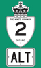
History of King's Highway 2A (Alt.) Cornwall:
King's Highway 2A (Alt.) was a short-lived alternate route that was established in Cornwall in 1965. The route of Highway 2A (Alt.) branched off of Highway 2 at the
intersection of Second Street and Brookdale Avenue. The route followed Second Street and Nine Mile Road (now known as Power Dam Road). Highway 2A (Alt.) joined up
with Highway 2 at the intersection of Nine Mile Road and Vincent Massey Drive. It is not certain if this road was ever signed as Highway 2A. It is possible that the
Department of Highways signed this highway as "Highway 2" with an "ALT." or "Alternate" tab below the route marker. The route of Highway 2A (Alt.) was decommissioned
in 1967. Two unrelated Highway 2A (Alt.) Routes also existed in London and
Chatham. 
 |
|---|
Links to Adjacent King's Highway Pages: 


Website contents, photos & text © 2002-2025, Cameron
Bevers (Webmaster) - All Rights Reserved / Contact Me |
|---|
