| 
| |
|
|
History of King's Highway 31:
King's Highway 31 was an arterial highway in Eastern Ontario which once passed through the Regional Municipality of Ottawa-Carleton and the United Counties of
Stormont, Dundas & Glengarry. The highway existed from the late 1920s up until the late 1990s, when it was downloaded in its entirety to municipalities.
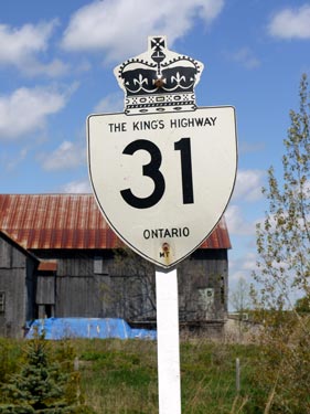
Highway 31 was one of many provincial highways in Eastern Ontario lost during the provincial highway downloading spree of 1997 and 1998. Highway 31 was first established in 1927, when the road from Morrisburg northerly towards Ottawa was assumed as a new provincial highway. A Preliminary Route Plan was prepared by the Department of Public Highways of Ontario (DPHO) dated June 11, 1927, which showed the proposed route of a new Provincial Highway through the County of Dundas. The route began at the Highway 2 Junction in Morrisburg and ran north for approximately 24 miles (38 km) to the Dundas-Carleton County Boundary. For many years, the route of Highway 31 ended rather arbitrarily at the county boundary line. The remainder of the route from the Carleton County Boundary to Ottawa remained a county road for nearly a decade after Highway 31 was first assumed by the DPHO. Provincial Highway 31 was first assumed by the DPHO through the County of Dundas on July 2, 1927 (See Map). Initially, Highway 31 was not assumed by the province within the incorporated limits of the Village of Winchester or the Village of Morrisburg. However, Highway 31 was partially-assumed through Winchester and Morrisburg the following year. A Preliminary Route Plan was prepared by the DPHO dated April 10, 1928, which showed the proposed assumption of St. Lawrence Street from the southern Winchester village limits to Fred Street and the assumption of Main Street from the western Winchester village limits to the Winchester Fairgrounds as part of the provincial highway. The balance of Highway 31 through the Village of Winchester from Fred Street to the Winchester Fairgrounds was considered to be a non-assumed section of the provincial highway. For the Village of Morrisburg, a Preliminary Route Plan was prepared by the DPHO dated April 11, 1928, which showed the proposed assumption of Nine Mile Road from the Canadian National Railway (CNR) crossing in Morrisburg to the northern village limits as part of the provincial highway. The balance of Highway 31 through the Village of Morrisburg from the CNR crossing to the Highway 2 Junction was considered to be a non-assumed section of the provincial highway. Jurisdiction over both the Morrisburg and Winchester sections of Highway 31 described above were assumed by the DPHO on May 2, 1928. Provincial Highway 31 was re-designated as King's Highway 31 in 1930. Initially, Highway 31 was only a gravel-surfaced road. The first paving contract was completed in 1931, when Highway 31 was paved with a concrete surface from Winchester to the highway's northern terminus at the Dundas-Carleton County Boundary. The section of Highway 31 from Morrisburg to Williamsburg was paved with a concrete surface in 1933 and the section from Winchester to Winchester Springs was paved with a concrete surface in 1934. The last gravel-surfaced section between Williamsburg and Winchester Springs was paved with a concrete surface in 1936. As part of these highway improvements, about 2 miles of Highway 31 was relocated onto an improved alignment between Winchester Springs and Cass Bridge, along with the construction of a new bridge over the South Nation River in 1931. Jurisdiction over the old Highway 31 alignment via Hollister Road, Oak Valley Road and Cass Bridge Road was transferred to the municipality, effective August 1, 1937. In 1936, Highway 31 was extended northerly from the Dundas-Carleton County Boundary to Ottawa. A Preliminary Route Plan was prepared by the Department of Highways of Ontario (DHO) dated April 17, 1936, which showed the proposed assumption of a new King's Highway through Carleton County. The proposed highway was an extension of Highway 31 from the highway's old northern terminus at the county boundary northerly via Vernon and Greeley to the southern limits of the City of Ottawa at the Rideau River Bridge on Bank Street. The former Carleton County Road was also known as the Metcalfe Road and was already paved at the time of assumption. The DHO acquired the Metcalfe Road on July 29, 1936 (See Map). This extension of Highway 31 brought the total length of the highway up to 48 1/2 miles (78 km). Work began in 1937 on two major revisions to the route of Highway 31 near Vernon and near Metcalfe. These highway reconstruction projects removed several bad curves in the old highway and resulted in the replacement of two bridges over the Castor River. These two diversions, located to the north and south of Vernon, were opened to traffic with a gravel surface in 1939 and were paved in 1944. Jurisdiction over the old Highway 31 alignment through Vernon via Boyd Road and Lawrence Street was transferred from the DHO to the municipality, effective September 15, 1944. Jurisdiction over the old Highway 31 alignment near Metcalfe via Snake Island Road and Scriven Drive was also transferred from the DHO to the municipality, effective September 15, 1944. As the City of Ottawa's boundaries expanded after World War II, the DHO began to transfer jurisdiction over Highway 31 to the city. The DHO transferred approximately 3 miles of Highway 31 lying between the old city limits at the Rideau River Bridge and the new city limits located just south of Hunt Club Road to the City of Ottawa, effective April 17, 1950. A short diversion was built for Highway 31 at Greeley in 1956. The old route of Highway 31 via Meadow Drive was transferred to the Township of Osgoode, effective September 30, 1957. Another change took place at the highway's southern terminus in Morrisburg in 1957, where the route of Highway 31 was truncated at the relocated Highway 2 Junction, rather than continue south via Ottawa Street to meet the original route of Highway 2 in the village centre. This change took place due to the construction of the St. Lawrence Seaway in the 1950s. Several new routes for Highway 31 have been established over the years within the City of Ottawa. As originally established in the 1930s, the route of Highway 31 followed Bank Street northerly from the city limits into Downtown Ottawa, where the highway ended at Wellington Street (Highway 17). A new route debuted in 1940 which had Highway 31 turn east from Bank Street onto Pretoria Avenue, concurrently with Highway 15, Highway 16 and Highway 17. At Rideau Canal Drive (today's Queen Elizabeth Drive), all four highways turned left and continued north into Downtown Ottawa. The existing route of Highway 31 was retained along Bank Street between Pretoria Avenue and Wellington Street, concurrently with a city-signed alternate route for Highway 16. The Highway 31 route along the Rideau Canal was most likely a city-established "scenic" route, as the DHO's post-1940 mileage logs still noted the northern terminus of Highway 31 at the Wellington Street Intersection (Highway 17) in Ottawa, with no change in the highway's mileage (48.4 miles). Some post-1940 maps indicate that Highway 31 was signed continuously along Bank Street into Downtown Ottawa, while others indicate that Highway 31 only followed Rideau Canal Drive beyond Pretoria Avenue. Between 1940 and 1946, the Official Ontario Road Map shows the two routes of Highway 31 leading into Downtown Ottawa, but the continuous Bank Street route was omitted from maps dated between 1947 and 1954. It is not clear if the Bank Street route was actually signed after 1947, but it is quite likely that the routes continued to be signed even though they were omitted from the Official Ontario Road Maps. In 1955, a new route was established for Highway 31 that had the highway turn directly onto Rideau Canal Drive from Bank Street. The old route via Bank Street and Pretoria Avenue was omitted on the 1955 Official Ontario Road Map. However, in 1956, the old continuous route of Highway 31 via Bank Street was restored, as it was prior to 1947 (See Map). The route of Highway 31 was marked this way on Official Road Maps up until 1960, when all scenic routes of Highway 31 were apparently eliminated. The post-1960 route of Highway 31 followed Bank Street to Heron Road, where it turned westerly towards Bronson Avenue. The highway then followed Bronson Avenue northerly to Highway 31's new northern terminus at the intersection of Bronson Avenue and Carling Avenue (Highway 17). This route, along with a northerly extension of Highway 31 via Bronson Avenue, Albert Street and Booth Street to the Chaudiere Bridge at the Ontario-Quebec Boundary, was formally designated as a Municipal Connecting Link in 1968. Despite this, there is contradictory information regarding the exact northern terminus of Highway 31 on virtually all Official Ontario Road Maps, where the northern terminus of Highway 31 was illustrated as the Ottawa Queensway (Highway 417). This northern terminus at the Ottawa Queensway is shown on all Official Ontario Road Maps produced between the mid-1960s and the late 1990s, with the solitary exception of the 1977 Edition. That map correctly illustrates the route of Highway 31 continuing north to the Chaudiere Bridge, which matches the Municipal Connecting Link route. The official DHO/MTO mileage logs produced between 1970 and 1997 also indicate that Highway 31 continued north to the Ontario-Quebec Boundary at the Chaudiere Bridge. Historical records also suggest that there was once a proposal in the late 1950s to relocate Highway 31 onto a new alignment through Ottawa. The proposal involved a southerly extension of Bronson Avenue as an arterial highway on a brand new alignment from the Rideau Canal southerly to the city limits at Hunt Club Road. The proposed route included a new bridge across the Rideau River (the George Dunbar Bridge) and a new interchange at Riverside Drive. A new high-level bridge across the Rideau Canal was also proposed, along with interchanges at the two scenic driveways along either side of the canal. The proposed route largely paralleled the Canadian Pacific Railway (CPR) south of Heron Road. Although the proposal never appeared to have gotten beyond the conceptual planning stages south of the Ottawa City Limits, the proposed route of Highway 31 through the City of Ottawa was ultimately constructed as the Airport Parkway. By the mid-1960s, DHO planning studies indicated that improvements to other parallel corridors such as the relocated Highway 16 and the proposed Cornwall-Casselman Highway (Highway 138) would attract far greater traffic volumes than a relocated Highway 31 would cater to. The proposal to extend the relocated Highway 31 south of Hunt Club Road appears to have been abandoned long before any highway designation plans were laid down by the DHO. In 1966, DHO's Eastern Ontario Planning Study recommended the construction of a new bypass around the southern side of Winchester in order to carry Highway 31 & Highway 43 traffic. The proposed Winchester Bypass was designated as a King's Highway by an Order-in-Council, effective February 18, 1971. Construction of the new Winchester Bypass commenced in 1971. The new Winchester Bypass was completed in 1974 and included a grade-separated crossing of the CPR. A roughly 3 km section of the former route of Highway 31 & Highway 43 through the Village of Winchester via Main Street and St. Lawrence Street was transferred to the Township of Winchester and the Village of Winchester, effective December 17, 1975. About 1.2 km of the old highway from Fred Street northwesterly to the Winchester Fairgrounds (the present day site of the Joel Steele Community Centre) was previously designated as a Municipal Connecting Link and was thus not under provincial jurisdiction. During the 1990s, it was determined that Highway 31 served primarily a local purpose and was transferred or "downloaded" by the province to area municipalities. An 11 km section of Highway 31 was downloaded from the province to the Regional Municipality of Ottawa-Carleton between the southern limits of the City of Ottawa near Hunt Club Road and Ottawa-Carleton Road 8 (Mitch Owens Road). This section of Highway 31 was transferred to Ottawa-Carleton, effective March 31, 1997. The remainder of Highway 31 from Ottawa-Carleton Road 8 southerly to Morrisburg was transferred from the province to the Regional Municipality of Ottawa-Carleton and the United Counties of Stormont, Dundas & Glengarry, effective January 1, 1998. Former Highway 31 is now known as Stormont, Dundas & Glengarry County Road 31 and Bank Street, Heron Road & Bronson Avenue within the City of Ottawa. Apart from Ottawa, Highway 31 passes through a predominantly rural area. The principal towns located along the highway are Ottawa, Winchester and Morrisburg. Most sections of Highway 31 are two lanes, but the highway is four lanes approaching Ottawa. Services along Highway 31 are generally quite plentiful near Ottawa, but services become somewhat sporadic towards the southern end of the highway. Even though it is no longer a provincial highway, the rural section of the route between Ottawa and Morrisburg is still commonly referred to as "Highway 31" by motorists. The speed limit on Highway 31 is 80 km/h (50 mph), unless posted otherwise. Please visit the Highway 31 Mileage Chart page for a list of mileage reference points along Highway 31. 
 |
|---|
Additional Information About King's Highway 31:
King's Highway 31 - Route Information (At Scott Steeves' website: asphaltplanet.ca)
King's Highway 31 - A Virtual Tour (At Scott Steeves' website: asphaltplanet.ca) |
|---|
Links to Adjacent King's Highway Pages: 

Website contents, photos & text © 2002-2025, Cameron
Bevers (Webmaster) - All Rights Reserved / Contact Me |
|---|