| 
| |
|
|
History of King's Highway 3B (Windsor):
King's Highway 3B was created out of a route renumbering in 1935, when the existing route of
Highway 3A leading into the City of Windsor was renumbered as Highway 3B. The highway's route began
at Oliver in South Sandwich Township. Highway 3B began at the Highway 3 Junction and followed Howard Avenue and Dougall Avenue into the city centre, where the highway
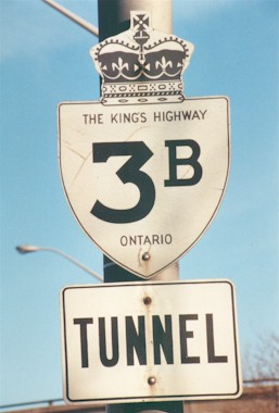
connected to the Detroit-Windsor Tunnel. As originally established in 1935, provincial jurisdiction over Highway 3B ended at the Windsor City Limits, where Dougall
Avenue crossed over the Canadian Pacific Railway south of Tecumseh Road. From that point northwesterly to the tunnel entrance, Highway 3B was entirely under municipal
jurisdiction. The City of Windsor signed Highway 3B along Dougall Avenue up to Tecumseh Road, where the highway turned right and headed east along Tecumseh Road to
Ouellette Avenue. Highway 3B then turned left onto Ouellette Avenue and headed northwesterly into Downtown Windsor. In 1958, the Highway 401 Tunnel Route was
completed and opened to traffic. The Tunnel Route of Highway 401 ended at an interchange with Howard Avenue (Highway 3B). As a result of the interchange construction,
Highway 3B was relocated onto the freeway ramps through the interchange. Jurisdiction over the bypassed section of Highway 3B along Dougall Avenue in the vicinity of
Downey Drive was transferred from the Department of Highways of Ontario (DHO) to the Township of Sandwich West, effective December 11, 1958. In the late 1950s, planning got underway for major improvements to Highway 3B at the southeast entrance to Windsor. Under the proposal, Ouellette Avenue was to be extended between Tecumseh Road and Dougall Avenue through Jackson Park. The Ouellette Avenue Extension through Jackson Park would eliminate an awkward jog in the route of Highway 3B between Dougall Avenue and Ouellette Avenue. A large railway overhead on the proposed diversion would bypass several at-grade railway crossings. The Jackson Park Diversion was formally designated as a Municipal Connecting Link by an Order-in-Council, effective May 28, 1959. This designation, which extended from Tecumseh Road to the Windsor City Limits at the Canadian Pacific Railway, was in place long before construction started on the diversion in 1961. When the Jackson Park Diversion and railway overhead was completed in 1962, the route of Highway 3B was shifted onto the newly-completed diversion. Jurisdiction over the bypassed section of Highway 3B along Dougall Avenue between the Windsor City Limits and Ouellette Avenue (now known as Ouellette Place) was transferred from the DHO to the Township of Sandwich West, effective April 1, 1964. In 1966, the City of Windsor expanded its limits significantly when it annexed or otherwise amalgamated with several adjacent towns and townships. Following the municipal amalgamation, the entire route of Highway 3B was contained within the City of Windsor's boundaries. It was decided that jurisdiction over the entire route of Highway 3B would be transferred from the province to the City of Windsor. About 3 1/2 miles (just under 6 km) of the provincially-owned portion of Highway 3B from the Highway 3 Junction at Oliver to the pre-1966 Windsor City Limits at the Canadian Pacific Railway near Tecumseh Road was transferred from the province to the City of Windsor, effective August 27, 1966. Initially, there was no Municipal Connecting Link designation in place apart from the Jackson Park Diversion, although the route of Highway 3B continued to be signed by the City of Windsor for wayfinding purposes. The section of Highway 3B from the Highway 401 Tunnel Route Interchange to Granada Avenue was designated as a Municipal Connecting Link by an Order-in-Council, effective September 3, 1970. All previously un-designated sections of Highway 3B from Granada Avenue northwesterly to the Detroit-Windsor Tunnel were designated as part of the Municipal Connecting Link, effective January 3, 1973. Interestingly, the section of Highway 3B via Howard Avenue between the Highway 3 Junction and the Highway 401 Tunnel Route Interchange was never designated as part of the Municipal Connecting Link. The City of Windsor discontinued signing Highway 3B via Howard Avenue at some point in the 1970s. The Howard Avenue section of Highway 3B does not appear on the Official Ontario Road Map after 1976, which suggests that signing of the route was discontinued around that time. However, since this portion of the route of Highway 3B was entirely under municipal jurisdiction with no formal Municipal Connecting Link designation in place, it is hard to determine exactly when the Howard Avenue section ceased to be signed as Highway 3B. The Municipal Connecting Link route of Highway 3B remained in service from the Highway 401 Tunnel Route Interchange to the Detroit-Windsor Tunnel until 1997, when the designation was removed. The Municipal Connecting Link designation was revoked by a Minister's Order, dated September 16, 1997. The former route of Highway 3B is now known as Ouellette Avenue, Ouellette Place and Dougall Avenue. Another Highway 3B route was located in Tillsonburg, but this highway was not related in any way to Windsor's Highway 3B. 
 |
|---|
Additional Information About King's Highway 3B (Windsor):
King's Highway 3B - Route Information (At Scott Steeves' website: asphaltplanet.ca)
King's Highway 3B - A Virtual Tour (At Scott Steeves' website: asphaltplanet.ca) |
|---|
Links to Adjacent King's Highway Pages: 


Website contents, photos & text © 2002-2025, Cameron
Bevers (Webmaster) - All Rights Reserved / Contact Me |
|---|