| 
| |
|
|
History of King's Highway 40C:
King's Highway 40C is one of Ontario's most peculiar and mysterious highway routes. During the early 1960s, a Downtown Sarnia highway route known as Highway 40C was
established. It is believed that the route was established sometime in late 1963, as the highway was not listed in the 1963 Mileage Logs issued earlier that year by
the Department of Highways of Ontario (DHO). As with neighbouring Highway 40B, there is often conflicting information in historical documentation about the route of
Highway 40C. What is known for certain is that a very short section of Highway 40C was established in 1964 via Front Street that was fully under provincial
jurisdiction. The balance of the highway's route through Sarnia south of Exmouth Street was under municipal jurisdiction and was not designated as a Municipal
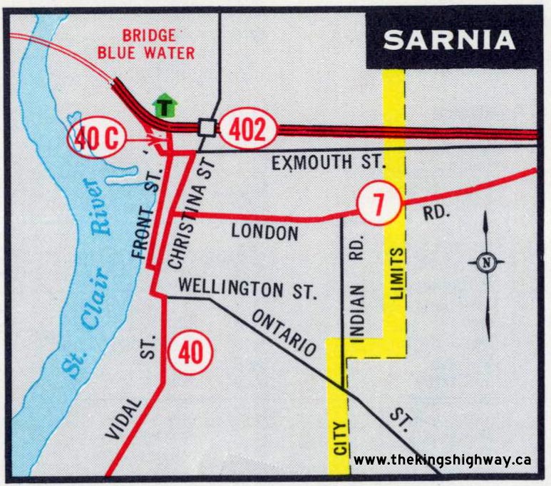
Connecting Link route. This makes it difficult to ascertain what the "official" route of Highway 40C actually was. According to mileage logs and inventories produced by the DHO after 1963, the route of Highway 40C began at the intersection of Vidal Street (Highway 40) and Wellington Street. Highway 40C then ran westerly along Wellington Street for two blocks to Christina Street, where Highway 40C turned north. At the intersection of Christina Street and Cromwell Street, a one-way street system began. One direction of Highway 40C traffic reportedly continued along Christina Street through Downtown Sarnia up to Exmouth Street, where the route looped back and connected to the opposing direction of Highway 40C. This one-way street system reportedly ended at the intersection of Exmouth Street and Front Street. The opposing direction of Highway 40C traffic followed Front Street from the intersection of Exmouth Street through Downtown Sarnia to Cromwell Street. The one-way street system then came to an end at the intersection of Cromwell Street and Christina Street. The Downtown Sarnia route of Highway 40C was not designated as a Municipal Connecting Link route. In 1963, the DHO began the process of assuming a new route for Highway 40C within the neighbouring Village of Point Edward. An Assumption Plan was prepared dated December 20, 1963, which showed a 0.15-mile section of Sarnia Road (today's Front Street) south of Highway 402 as a proposed King's Highway known as Highway 40C. This plan was registered on January 6, 1964, and was officially designated as a King's Highway (Highway 40C) by an Order-in-Council, effective February 6, 1964. This new route of Highway 40C was first shown on the 1965 Edition of the Official Ontario Road Map (See Map). Official Road Maps issued prior to 1965 illustrate a highway route through Downtown Sarnia, but these maps do not explicitly state that the route was known as Highway 40C. However, DHO mileage logs and highway inventories issued throughout the mid-to-late 1960s show the route of Highway 40C extending south through Downtown Sarnia from the intersection of Exmouth Street and Front Street, via the route outlined above. The Old Bluewater Bridge Road (known today as Venetian Boulevard) which extended northwesterly from Exmouth Street out to Highway 402 was also considered to be a part of Highway 40C. Historically, the Old Bluewater Bridge Road had been signed as Highway 7 & Highway 40. However, once the new Sarnia Bypass was completed in 1965, the route of Highway 40 was rerouted along the new bypass. This numbering situation would have left the Old Bluewater Bridge Road without a highway number, since Highway 7 was truncated at Front Street in Downtown Sarnia during the mid-1960s. It is believed that most (if not all) of Highway 40C through Downtown Sarnia was renumbered as Highway 40B before 1970, as the route was omitted from DHO mileage logs produced after 1968. It is possible that the route of Highway 40C was still signed after 1970, but this has not yet been confirmed. It is also noted that a portion of Highway 40C would have overlapped with Highway 40B via Front Street between London Road and Exmouth Street, which seems like an unnecessarily convoluted urban route setup. It is also possible that the one-way street system described in the 1965 and 1968 DHO Mileage Logs was proposed during the 1960s, but was in fact never fully implemented. Historical photographs of Downtown Sarnia from the late 1950s through late 1970s seem to suggest that Front Street and Christina Street were actually operating as two-way streets at various points. If a one-way street system was indeed introduced, it might not have been in operation for very long. The route of Highway 40C is believed to have vanished sometime during 1969. The provincially-maintained section of Highway 40C which extended south from Highway 402 to Exmouth Street via Front Street was omitted from all mileage logs produced after 1968, but then suddenly reappeared in the 1978 Mileage Logs after a 10-year absence. However, this section of the highway was now indicated to be a part of Highway 40B. Although the route appeared as Highway 40B for the first time in 1978, it is probable that the route had been signed as Highway 40B for several years. Regardless of the highway's posted route number, jurisdiction over this short provincially-maintained section of highway was transferred over to the Village of Point Edward, effective November 15, 1984. Highway 40C was one of only three "C" suffixed highway route numbers in Ontario. The other two routes were Highway 3C near Fort Erie and Highway 7C near Peterborough.  |
|---|
Links to Adjacent King's Highway Pages: 


Website contents, photos & text © 2002-2024, Cameron
Bevers (Webmaster) - All Rights Reserved / Contact Me |
|---|