
| 
| |
|
|
History of Secondary Highway 519 (#1):
The first Secondary Highway 519 was a local highway in the Provisional County of Haliburton that provided access to a number of small communities in the central part
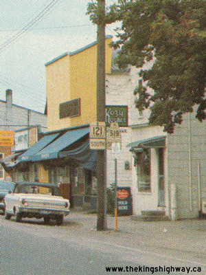
of the County. Highway 519 began at Highway 121 north of Kinmount and headed northerly via Gelert and Donald to Haliburton Village, where Highway 519 joined up again
with Highway 121. Highway 519 then continued north from Haliburton Village to Redstone Lake Landing, via Eagle Lake. Highway 519 was first depicted on a Preliminary
Route Plan prepared by the Department of Highways of Ontario (DHO) in April, 1956. The route, which had been known previously as the Eagle Lake Road and Donald Road,
was designated by an Order-in-Council dated May 9, 1956. Highway 519 was approximately 35 miles (56 km) in length. The highway was mostly gravel-surfaced at first.
The only section of Highway 519 that was paved the time of designation in 1956 ran from Haliburton Village to Eagle Lake. A primed bituminous surface was placed along
the balance of Highway 519 during 1956. A cold mix asphalt surface was placed along Highway 519 between the Highway 121 Junction north of Kinmount and Lochlin in
1962. Improvements continued along Highway 519 throughout the mid-1960s, and the highway was first shown with a completely paved surface on the 1966 Edition of the
Ontario Official Road Map.
As originally established in 1956, Highway 519 was under provincial jurisdiction for its entire length. A 1 km section of Highway 519 ran concurrently with Highway 121 along Highland Street in Haliburton Village. A portion of Highway 121 & Highway 519 through Haliburton Village was transferred from the province to the Township of Dysart et. al. on May 4, 1968. The transferred section of Highway 519 began at Cedar Avenue and extended east along Highland Street and north along Maple Avenue to York Street. This transferred section of Highway 519 was designated as a Municipal Connecting Link by an Order-in-Council, effective May 9, 1968. This Municipal Connecting Link was extended north along Highway 519, when the section of Highway 519 between York Street and the end of Sunnyside Street near Head Lake was transferred to the Township of Dysart et. al. on August 28, 1981. In addition, the section of Highway 121 & Highway 519 between Cedar Avenue and the Highway 519 South Junction was also transferred to the municipality. These newly-transferred sections of Highway 519 were designated as extensions to the Municipal Connecting Link by an Order-in-Council, effective December 17, 1981. During the early 1980s, several major changes took place to the highways in Haliburton County. The entire route of Highway 530 and a portion of Highway 519 were incorporated into the eastern extension of Highway 118 from Bracebridge to Haliburton Village. Both of these Secondary Highways were legally re-designated as King's Highway 118 by an Order-in-Council, effective June 2, 1983. Curiously, however, the 1982-1983 Edition of the Official Ontario Road Map and the 1982 Provincial Highway Mileage Logs both suggest that Highway 519 and Highway 530 had already been renumbered with Highway 118 signs prior to January 1, 1982. The timing of this apparent highway renumbering coincided with the extension of Highway 118 from Bracebridge to Carnarvon, which took place in late 1981. The 1983 Order-in-Council date has been taken as the "official" date that the section of Highway 519 north of Haliburton Village was renumbered as Highway 118. However, it should be noted that the highway signs along both Highway 519 and Highway 530 were probably changed well before June, 1983 (most likely in late 1981). In addition, jurisdiction over the southernmost section of Highway 519 from a point just south of Haliburton Village to the Highway 121 Junction was transferred from the province to the County of Haliburton. This 31 km section of Highway 519 from the Highway 121 Junction north of Kinmount to Highlandwood Drive (today's Grass Lake Road) near Haliburton Village was transferred to the County of Haliburton, effective October 29, 1981. This section of Highway 519 was subsequently renamed Haliburton Road 1. For some unknown reason, the balance of Highway 519 from Highlandwood Drive to the Highway 121 Junction in Haliburton Village was retained in the provincial highway system for many years after 1981. This section of Former Highway 519 was apparently assigned an unposted 7000-series highway number in 1981, as it was no longer marked as a provincial highway on maps, nor was this section of the route listed in any of the Ministry of Transportation and Communications (MTC's) mileage logs. It should also be noted that the Highway 519 designation was ultimately selected for reuse on the Dubreuilville Highway in the District of Algoma in 1985. This mysterious 700 metre remainder of Former Highway 519 south of Haliburton Village was finally transferred to the County of Haliburton, effective March 31, 1997. With the southern section of Highway 519 decommissioned, the MTC sought to transfer the northern section of Highway 519 to Haliburton County as well. After completing a series of upgrades to the highway in the early 1980s, the MTC transferred the remaining 15.3 km section of Highway 519 from the Highway 118 Junction northerly to Redstone Lake Landing, effective April 1, 1984. The Highway 519 designation was thus retired, albeit temporarily. The route number was used again on an unrelated Highway 519 which was established north of Wawa in 1985. |
|---|
Links to Adjacent Secondary Highway Pages: Website contents, photos & text © 2002-2025, Cameron
Bevers (Webmaster) - All Rights Reserved / Contact Me
|
|---|