| 
| |
|
|
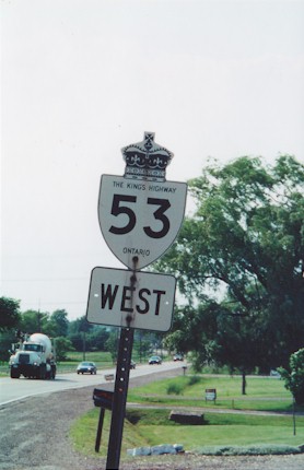
History of King's Highway 53:
King's Highway 53 was a major collector highway which linked Woodstock to Hamilton, via Brantford. Until the route of Highway 403 was completed in 1997, Highway 53
served as an important through route. The completion of Highway 403 drastically reduced the importance of Highway 53, which ultimately resulted in the highway being
transferred to municipalities during the mass Ontario provincial highway downloading rounds of 1997-1998. The history of Highway 53 dates back to 1935, when the Burford Road was assumed as a new provincial highway between Brantford and Eastwood, just east of Woodstock. Highway 53 was originally intended to serve as an alternate route to a congested section of Highway 2 between Brantford and Woodstock. A Preliminary Route Plan was prepared by the Department of Highways of Ontario (DHO) dated May 30, 1935, showing the proposed route of a new King's Highway through Brant County, while a second Preliminary Route Plan dated May 31, 1935, showed the proposed route of the new King's Highway through Oxford County. The Burford Road was assumed by the DHO between Brantford and Eastwood as a new King's Highway on August 14, 1935. Initially, Highway 53 began at Highway 2 & Highway 24 in Downtown Brantford and extended west for 36 km, where it connected back to Highway 2 at Eastwood. According to DHO mileage logs, Highway 53 continued west between Eastwood and Woodstock concurrently with Highway 2 for an additional 7 km. The total length of Highway 53 from Brantford to Woodstock was therefore 43 km. The sections of the route passing through Woodstock and Brantford were not assumed by the DHO, and thus those sections of Highway 53 remained under municipal jurisdiction. Most sections of Highway 53 were already paved when it was assumed as a King's Highway in 1935. The only gravel-surfaced section was between Eastwood and Cathcart. However, this gravel-surfaced section was paved during highway improvement projects carried out in 1937 and 1938. In 1937, Highway 53 was extended easterly from Brantford to the Highway 20 Junction at Elfrida, southeast of Hamilton. This was accomplished by co-designating Highway 53 with Highway 2 between Brantford and Duff's Corners and supplanting the designation of the former route of Highway 20A from Duff's Corners to Elfrida with the Highway 53 designation. By the end of 1937, Highway 53 had grown to 86 km in length. In the late 1940s, growing traffic congestion prompted the DHO to widen Highway 2 and Highway 53 between Brantford and Ancaster to four lanes. Construction began to widen the existing two lane highway in 1949. The resulting four-lane undivided highway was more or less completed by 1952. In 1954, the concurrent routing of Highway 2 and Highway 53 between Woodstock and Eastwood was discontinued. That year, DHO mileage logs ceased to indicate that Highway 53 began in Woodstock. Instead, the western terminus of Highway 53 was reported as being at the Highway 2 Junction in Eastwood. The section of Highway 53 passing through Brantford via Colborne Street was not assumed by the DHO. As originally assumed, provincial jurisdiction of Highway 53 ended at Shellard Lane on the western side of Brantford. Provincial jurisdiction resumed again on the eastern side of Brantford at Stanley Street. As Brantford grew larger during the 1940s and 1950s, sections of the highway were transferred to the municipality. A 2 km section of Highway 53 from the Brantford City Limits near Pleasant Ridge Road to Shellard Lane was transferred to the City of Brantford on April 12, 1955. A 3 km section of Highway 2 & Highway 53 between Stanley Street and Garden Avenue was transferred to Brantford on June 27, 1955. The DHO established a Municipal Connecting Link Agreement with Brantford for most sections of Highway 53 passing through the city. This agreement provided cost-sharing mechanisms for major capital construction upgrades to the section of Highway 53 within Brantford. Almost the entire length of Highway 53 (Colborne Street) through Brantford was designated as a Municipal Connecting Link by an Order-in-Council, effective March 31, 1966. The Municipal Connecting Link through Brantford was repealed by a Minister's Order, effective September 16, 1997. This revocation coincided with the downloading of Highway 53 to Brant County earlier in 1997. Originally, the DHO owned all of Highway 53 through the current City of Hamilton. As Hamilton expanded southwards during the 1960s, a section of Highway 53 was transferred to the City of Hamilton. A 10 km section of Highway 53 lying between Glancaster Road and Trinity Church Road was transferred from the province to the City of Hamilton, effective April 22, 1961. This transferred section of Highway 53 was subsequently designated as a Municipal Connecting Link. The route of Highway 53 remained more or less unchanged up until the late 1990s. The completion of Highway 403 between Brantford and Woodstock in 1988 had a significant impact on the importance of Highway 53. Most long-distance through traffic began to use Highway 403 to travel between Brantford and Woodstock instead of Highway 53. This section of Highway 53 began to serve only a local purpose, so on March 31, 1997, the entire western section of Highway 53 from Eastwood to Brantford was downloaded to the Counties of Oxford and Brant. The road was subsequently renamed Oxford County Road 55 and Brant County Highway 53. The eastern section of Highway 53 from Elfrida to the Stoney Creek-Hamilton City Limits was also downloaded on March 31, 1997. The central section of Highway 53 survived a few months longer. Following the completion of Highway 403 between Brantford and Ancaster in 1997, the route of Highway 2 & Highway 53 between the two cities was also downloaded. The balance of Highway 53 between Duff's Corners and the Amcaster-Hamilton City Limits was downloaded to the Regional Municipality of Hamilton-Wentworth on October 1, 1997. The section of Highway 2 & Highway 53 between Brantford and Duff's Corners was transferred to Brant County and the Regional Municipality of Hamilton-Wentworth on September 1, 1997. In Brant County, the downloaded section of Highway 2 & Highway 53 was renamed Brant County Highway 2 & Brant County Highway 53. In the Region of Hamilton-Wentworth, the road was not renamed initially. The old King's Highway route markers were left in place for many years after the highway was downloaded. After the New City of Hamilton was created in 2001, the former route of Highway 2 & Highway 53 was renamed as Wilson Street, while the former route of Highway 53 from Duff's Corners to Elfrida was renamed Rymal Road and Garner Road. Highway 53 is predominantly a two-lane highway, with the exception of the undivided four-lane section between Brantford and Duff's Corners. The western section of Highway 53 west of Brantford is generally quite rural, while the eastern section through Hamilton is very urbanized. Services appear fairly frequently along Highway 53, except in some of the rural areas west of Brantford, where services are less frequent. The speed limit on Highway 53 is 80 km/h (50 mph), unless posted otherwise. Please visit the Highway 53 Mileage Chart page for a list of mileage reference points along Highway 53. 
 |
|---|
Additional Information About King's Highway 53:
King's Highway 53 - Route Information (At Scott Steeves' website: asphaltplanet.ca)
King's Highway 53 - A Virtual Tour (At Scott Steeves' website: asphaltplanet.ca) |
|---|