| 
| |
|
|
History of Secondary Highway 550:
Secondary Highway 550 is a local highway in the District of Algoma that extends westerly from Sault Ste. Marie to Gros Cap, a small community located on the eastern
shores of Lake Superior. Highway 550 was first designated by an Order-in-Council dated May 9, 1956. The new highway followed the Second Baseline Road (today's Second
Line) and was approximately 11 miles (18 km) in length. The entire highway was already paved at the time of designation in 1956. As originally assumed, the Department
of Highways of Ontario (DHO) owned Highway 550 from Gros Cap to the western boundary of Sault Ste. Marie, which at that time was located at the intersection of Korah
Road and Second Line. The balance of the highway within Sault Ste. Marie was not shown on any Official Ontario Road Maps prior to the 1963 Edition. By all accounts,
Highway 550 was not actually signed as a provincial highway east of the city limits from 1956 up until 1962.
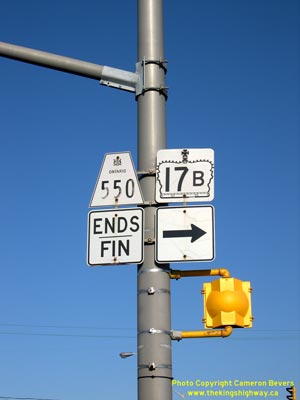
In 1962, two separate extensions were made to the route of Highway 550 through Sault Ste. Marie. Firstly, the logical easterly continuation of Highway 550 via Second Line was assumed by the DHO as a new provincial highway. A Preliminary Assumption Plan was prepared dated July 1962, which showed the planned assumption of Second Line from Korah Road easterly to the Highway 17 Junction (Great Northern Road). This plan was registered on August 28, 1962 and the new route was officially designated as an extension of Highway 550 by an Order-in-Council, effective October 18, 1962. It is believed that the route of Highway 550 was signed continuously through to Highway 17 via Second Line following that date, as the route was then fully under the jurisdiction of the DHO. However, the status of a second route of Highway 550 which led into Downtown Sault Ste. Marie was far less clear, and remained so for many years. On January 25, 1962, a new Municipal Connecting Link was established for Highway 550 within the City of Sault Ste. Marie by an Order-in-Council. The northerly portion of the Highway 550 Municipal Connecting Link was fairly straightforward, where the route began at Second Line and followed Korah Road, Lyons Avenue and Wellington Street southeasterly towards Downtown Sault Ste. Marie. The Municipal Connecting Link Route of Highway 550 supposedly turned south from Wellington Street via both Gloucester Street and Huron Street, as well as continuing straight ahead via Wellington Street. All three of these Highway 550 spur routes supposedly ended at Cathcart Street (Highway 17). This is reflective of the information purported on the 1963 Official Ontario Road Map, where it is inferred by a thick red line (indicative of a King's Highway) that Cathcart Street was part of Highway 17. This information is also consistent with DHO survey records, which show Cathcart Street as part of the Highway 17 Municipal Connecting Link. On the other hand, the 1963 DHO mileage tables tell a different tale. In the mileage tables, the route of Highway 550 is shown to begin at the two Highway 17 Junctions east of downtown, at the intersection of Church Street and Wellington Street (northbound) and at the intersection of Pim Street and Wellington Street (southbound). It was thus suggested in the 1963 mileage tables that the apparent "loop" of Highway 17 via Wellington Street, Cathcart Street, Huron Street, Queen Street, Bay Street and Pim Street was in fact part of Highway 550 and not actually Highway 17. Apart from the 1963 Edition, other DHO mileage tables issued during the 1960s do not list the downtown route of Highway 550 at all - only the more direct northerly route via Second Line was indicated. Conversely, many of the Official Road Maps of the 1960s only show the "downtown" route of Highway 550. To add to the mess, a recently-discovered but very detailed DHO record from 1966 indicates the sudden appearance of a Highway 550B route, which extended from the intersection of Huron Street and Wellington Street northwesterly to connect with Highway 550 at the intersection of Second Line and Korah Road. The mileage given for Highway 550B was 1.4 miles, which matches the length of the supposed "downtown" Highway 550 route via Korah Road, Lyons Avenue and Wellington Street. I've interpreted this drastically conflicting information as follows, based on the typical DHO route marking practices used at that time. Initially, Highway 550 went into Downtown Sault Ste. Marie from the intersection of Second Line and Korah Road, via the Municipal Connecting Link established in January 1962. Highway 550 ended at the intersection of Huron Street and Wellington Street, which according to the same 1966 document, was actually signed as Highway 17B. Once the "new" Second Line route of Highway 550 was established later in the Fall of 1962, the "old" route of Highway 550 established in January 1962 became Highway 550B. This theory is further supported by the fact that the routes of Highway 17B and Highway 550B, once they did both finally appear in DHO's mileage tables in 1970, exactly match this route description. It is also consistent with the information found in the DHO document from 1966. Until other evidence comes to light, this description of the routes of Highway 550 and Highway 550B will be presumed to be correct, despite how these highways are marked on some Official Ontario Road Maps. During the mid-1960s, the City of Sault Ste. Marie expanded its municipal limits. As a result, the DHO transferred a 6.3 mile section of Highway 550 to the city in 1966. This represented about half of the total length of Highway 550. Jurisdiction over the section of Highway 550 from Highway 17 (Great Northern Road) westerly to the new city limits (the eastern boundary of Prince Township) was transferred from the DHO to the City of Sault Ste. Marie, effective June 4, 1966. This entire section of Second Line from Highway 17 to the Sault Ste. Marie city limits was designated as a Municipal Connecting Link by an Order-in-Council, effective November 5, 1970. Despite the 1966 highway transfer, Highway 550's eastern terminus was always shown to be at Highway 17 (Great Northern Road) in DHO's mileage tables. It is therefore assumed that the route of Highway 550 was still being fully signed by the City of Sault Ste. Marie along Second Line, even though the route was not formally designated as a Municipal Connecting Link between 1966 and 1970. All Ontario Official Road Maps published from 1968 onwards show Second Line as the only route for Highway 550. The supposed "downtown" route of Highway 550 was marked as Highway 550B for the first time on the 1968 Official Ontario Road Map. In the late 1960s, a truck bypass route was established around Sault Ste. Marie. The proposed bypass followed Black Road and an easterly extension of Second Line. Curiously, early surveys for the Sault Ste. Marie Bypass indicated that the highway was initially planned to be numbered as an extension of Highway 550. This numbering situation would have created an odd condition, whereby the Trans-Canada Highway's main route would have followed an Ontario Secondary Highway for a little over 3 miles. An Assumption Plan was prepared for the Sault Ste. Marie Bypass in March 1969, with the route marked as "Highway 550, Trans-Canada". The plan was registered on March 31, 1969, which allowed the DHO to assume jurisdiction and control over the bypass effective that day. The Sault Ste. Marie Bypass was never formally designated as either a Secondary or a King's Highway by an Order-in-Council. This was likely because the DHO's ownership of the route was merely intended to be temporary while the new bypass was being constructed. On December 17, 1970, provincial jurisdiction over the bypass ended, when the entire route from Highway 17 (Great Northern Road) to Highway 17 (Trunk Road) was transferred to the City of Sault Ste. Marie. It is highly unlikely that the Sault Ste. Marie Bypass was ever actually signed as Highway 550, as some DHO documents from 1969 indicate that the Sault Ste. Marie Bypass was actually numbered as Highway 17. It should be noted that both the 1970 Official Ontario Road Map and 1970 DHO mileage tables also indicate the bypass was part of Highway 17, as it is today. Since 1966, the province has retained ownership of a 9.3 km section of Highway 550 from the western limits of the City of Sault Ste. Marie to Gros Cap. The Municipal Connecting Link designation for Highway 550 through Sault Ste. Marie was amended in 1997. A Minister's Order was signed on September 18, 1997, which stripped the Municipal Connecting Link designation from Highway 550 west of the Highway 550B Junction (Korah Road). A further section of the Highway 550 Municipal Connecting Link from Korah Road to John Street (now Carmen's Way) was revoked by a Minister's Order, effective March 29, 2006. Since 2006, the only remaining portion of the Highway 550 Municipal Connecting Link through Sault Ste. Marie is from Carmen's Way to Highway 17 (Great Northern Road). The route of Highway 550 is still signed through the city, albeit sporadically. Unless posted otherwise, the speed limit on Highway 550 is 80 km/h (50 mph). Services are available on this highway in Sault Ste. Marie and at the Highway 565 Junction east of Gros Cap. |
|---|
Links to Adjacent Secondary Highway Pages: Website contents, photos & text © 2002-2025, Cameron
Bevers (Webmaster) - All Rights Reserved / Contact Me |
|---|