| 
| |
|
|
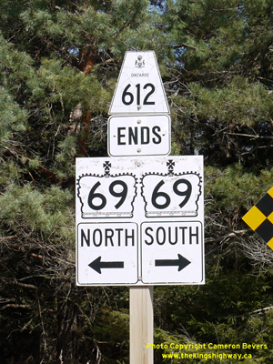
History of Secondary Highway 612 (#1):
Secondary Highway 612 was a local highway in the District of Algoma which briefly served the uranium mining region around Elliot Lake during the 1950s. Highway 612
was first designated as a Secondary Highway by an Order-in-Council, effective May 9, 1956. The highway began at Serpent River on Highway 17 and extended north for
just under 32 1/2 miles (52 km) to Quirke Lake. During 1956 and 1957, major upgrades were made to the route of Highway 612, including substantial realignment and
curve straightening. Not only did this reconstruction of Highway 612 drastically improve the alignment of the highway, it also shortened the highway distance between
Highway 17 and Quirke Lake by several miles. By the end of 1957, the entire length of the highway had been improved and paved. It was then decided to re-designate
Highway 612 as a King's Highway. In December 1957, the changeover in designations began and this continued until January 1958, when the Highway 612 designation had
been replaced in its entirety by the new Highway 108 designation. Another, unrelated
Highway 612 was established in the Districts of Muskoka and Parry Sound in 1960.
|
|---|
Links to Adjacent Secondary Highway Pages: Website contents, photos & text © 2002-2025, Cameron
Bevers (Webmaster) - All Rights Reserved / Contact Me |
|---|