| 
| |
|
|
History of King's Highway 66:
King's Highway 66 is a collector highway which extends from Matachewan easterly to the Ontario-Quebec Boundary in the District of Timiskaming, via Swastika and
Kirkland Lake. Highway 66 owes its existence largely due to the Kirkland Lake Gold Rush of the 1920s and 1930s. This highway passes right through the rich gold fields
that first stimulated settlement in the area, which in turn created the villages and towns of Matachewan, Swastika, Chaput Hughes, Kirkland Lake, Larder Lake and
eventually, Virginiatown. During the early 1930s, a new Northern Development Trunk Road was constructed from the Ferguson Highway (Highway 11) near Kirkland Lake to
serve the new mining camps that had been established in the area. When the Department of Northern Development was amalgamated with the Department of Highways of
Ontario (DHO) in 1937, jurisdiction over the Kirkland Lake-Cheminis Trunk Road was transferred to the DHO. A Preliminary Route Plan was prepared in April 1937,
showing the proposed route of the new King's Highway between Kirkland Lake and the Ontario-Quebec Boundary east of Virginiatown. This new route was designated as
King's Highway 66 (See Map). As originally assumed on September 22, 1937, the
26-mile route of Highway 66 actually began at Goodfish Road (today's Duncan Avenue) near the eastern end of Kirkland Lake. Interestingly, the balance of the route of
Highway 66 from Kirkland Lake westerly to the Highway 11 Junction near Swastika was not an assumed section of the King's Highway for several years. This was a very
active mining area in the late 1930s, and given the patchwork of mining claims, the surveying and establishment of a permanent highway route through the gold field
would have been very difficult. Apparently, this non-assumed section of Highway 66 between the Highway 11 Junction and Kirkland Lake was still signed as a continuous
through route, as the Official Road Map of Ontario and DHO mileage logs from the late 1930s show that the route of Highway 66 began at the Highway 11 Junction near
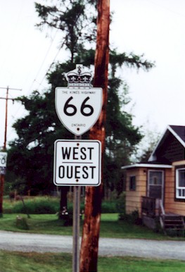
Swastika and had a total length of 33.7 miles (54 km). During the War Years, public pressure arose to change the name of "Swastika" (at the western end of Highway 66) to "Winston". Local residents, determined to preserve their town's heritage refused to change the town's name, as the name had been in place long before the use of the swastika as a symbol of Germany's Nazi Party. Nevertheless, the town is marked as "Winston" (after Winston Churchill) on the 1941, 1942, and 1945-6 editions of the Ontario Official Road Map. This temporary name change meant that DHO mileage logs indicate the western terminus of Highway 66 during the war years as "Winston" and not "Swastika" as in previous and subsequent years. When the route of Highway 66 was first established in 1937, the majority of the highway from Swastika to the Ontario-Quebec Boundary was gravel-surfaced. The section of Highway 66 between Swastika and Kirkland Lake was paved prior to becoming a King's Highway, which attests to the region's prosperity during the heady gold rush days of the 1930s. The balance of the highway would remain gravel-surfaced until the 1940s. Highway 66 was paved between Kirkland Lake and Larder Lake in 1944. The balance of the highway between Larder Lake and the Ontario-Quebec Boundary was paved in small stages during 1947 and 1948, thus completing paving work on the eastern leg of the highway. Highway 66 was extended westerly from Kirkland Lake during the 1950s. The remainder of Highway 66 from Kirkland Lake westerly to the Swastika Wye at Highway 112 (Formerly Highway 11) was officially assumed by the DHO in 1957, 20 years after the route of Highway 66 was first established. In November 1956, a Preliminary Route Plan was prepared showing the proposed assumption of Government Road leading west from Kirkland Lake. The new highway was assumed between the eastern limit of Mining Claim 5686 and Main Street in Kirkland Lake on April 10, 1957. The balance of Government Road between the Highway 112 Junction and the easterly limit of Mining Claim 5686 was assumed by the DHO on July 25, 1957. The rest of Government Road through the built-up area of Kirkland Lake between Main Street and Duncan Avenue was designated as Highway 66 by an Order-in-Council dated July 9, 1959. The entire route of Highway 66 through the built-up portion of Kirkland Lake between Main Street and Burnside Drive was transferred from the province to the Township of Teck, effective April 22, 1961. This urban section of Highway 66 was subsequently designated as a Municipal Connecting Link by an Order-in-Council dated November 7, 1963. A section of Highway 66 between Kenogami Lake and the Swastika Wye was originally considered to be a part of Highway 11. Back in 1941, part of Highway 11 was bypassed by a new, more direct highway route to the west of Round Lake. The completion of the Round Lake Diversion essentially created two routes for Highway 11 in the Kirkland Lake area. The new Round Lake Diversion formed a cut-off route which departed from Highway 11 at Tarzwell and reconnected with Highway 11 at Kenogami Lake. The original route of Highway 11 ran through Swastika and the Kirkland Lake area. Since both routes were considered to be part of Highway 11, the two routes became a source of confusion for motorists. The DHO eventually resolved this awkward highway number situation by renumbering the old Highway 11 alignment between Tarzwell and the Swastika Wye as Highway 112. The Round Lake Diversion, which was considerably shorter than the old route, retained the Highway 11 designation. The east-west portion of the old Highway 11 route via Swastika was renumbered as Highway 66 in 1953. This created a 9 km extension to the route of Highway 66, which now ended just west of Swastika at the Highway 11 Junction at Kenogami Lake (See Map). In the 1940s, planning began for the construction of a new mining access road from Highway 11 near Kenogami Lake to Matachewan. Construction began on the new mining road in 1947. Shortly after this mining road was completed in 1953, a decision was made to designate the new route as a western extension of Highway 66. On November 16, 1955, the DHO assumed the Matachewan-Kenogami Lake Road as a King's Highway, which extended the route of Highway 66 by a further 40 km (See Map). Initially, the Highway 66 extension between Kenogami Lake and Matachewan was only gravel-surfaced. Between 1961 and 1965, Highway 66 was paved between the Highway 11 Junction at Kenogami Lake and the Highway 65 Junction near Matachewan. Until 1971, Highway 66 ended at the Highway 65 Junction just east of Matachewan. In 1971, a route renumbering took place which resulted in Highway 65 being truncated at the Highway 66 Junction, and Highway 66 being extended westerly into Matachewan along the former route of Highway 65. The final extension into Matachewan added another 5 km to the length of Highway 66. During the late 1970s, a minor highway realignment took place at the offset highway junction of Highway 11 and Highway 66 at Kenogami Lake. The junction was reconstructed in 1979, so that the separate east and west legs of Highway 66 met Highway 11 at a single point. The rebuilt highway junction eliminated an overlapped route between Highway 11 and Highway 66 between the previously offset intersections at Kenogami Lake. No further changes were made to the route of Highway 66 until the late 1990s. On March 31, 1997, a section of Highway 66 between Goldthorpe Drive in Chaput Hughes and Main Street in Kirkland Lake was transferred to the Town of Kirkland Lake. The Municipal Connecting Link through Kirkland Lake was expanded in the 1990s to include this transferred section of Highway 66 between Chaput Hughes and Kirkland Lake. The expanded Municipal Connecting Link was designated by a Minister's Order dated January 21, 1999. This 3.7 km section of Highway 66 between Goldthorpe Drive and a point just east of Burnside Drive is now under municipal jurisdiction. Another relocation of Highway 66 took place through Virginiatown near the Ontario-Quebec Boundary in 2017 due to geotechnical reasons. This diversion bypassed the main street of Virginiatown, and in the process, extended the total length of Highway 66 by about 0.5 km. The old route of Highway 66 leading into Virginiatown was assigned an unposted 7000-series highway number (Highway 7312) and is now signed as Government Road. Highway 66 passes through some rather remote areas along its 104 km route. The only major town located along the highway is Kirkland Lake, although some smaller communities periodically appear along the eastern section of the highway. Highway 66 is a two-lane road for its entire length. Services are available in most larger communities along the highway. The speed limit on Highway 66 is 80 km/h (50 mph), unless posted otherwise. Some sections of Highway 66 east of Kenogami Lake are now posted at 90 km/h (55 mph). The section of Highway 66 lying east of the Highway 11 Junction is now part of the Trans-Canada Highway system, linking to Quebec's Highway 117. Signs marking the Trans-Canada Highway designation along Highway 66 were only recently added to the route in 2004. For many years, the route wasn't signed. Please visit the Highway 66 Mileage Chart page for a list of mileage reference points along Highway 66. 
 |
|---|
Additional Information About King's Highway 66:
King's Highway 66 - Route Information (At Scott Steeves' website: asphaltplanet.ca)
|
|---|
Links to Adjacent King's Highway Pages: 

 Website contents, photos & text © 2002-2026, Cameron
Bevers (Webmaster) - All Rights Reserved / Contact Me
|
|---|