| 
| |
|
|
History of Secondary Highway 666:
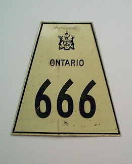
Secondary Highway 666 was a minor collector highway in the District of Kenora, which existed during the 1970s and early 1980s. The highway once connected the small
community of Redditt to Highway 17 in Kenora. The highway itself was first established in 1956, when the Redditt Road was designated as
Highway 128. In November 1973, the Ministry of Transportation and Communications (MTC) decided to
re-designate three minor King's Highways in Northwestern Ontario as Secondary Highways by the end of 1974. The three affected highways were Highway 116 near Sioux
Lookout, Highway 119 near Dryden and Highway 128 near Kenora. The common practice at the time was to number Secondary Highways in consecutive order, and the MTC
simply picked the next three route numbers that were available for assignment. Those three numbers were Highway 664 (assigned to former King's Highway 116),
Highway 665 (assigned to former King's Highway 119) and Highway 666 (assigned to former King's Highway 128). Highway 128 was formally re-designated as a Secondary Highway by an Order-in-Council, effective August 7, 1974. Route markers along King's Highway 128 were subsequently changed over to Secondary Highway 666 route markers. At the time, little thought had been given to the significance of the highway's new route number. However, the notoriety of this route number quickly began to be noticed. Facing mounting public pressure, compounded by the predictable problem of route marker thefts, the Ministry of Transportation decided to change the highway's route number to Highway 658 in 1985. Highway 666 was mostly paved when it was created in 1974, except for a gravel-surfaced section from Highway 598 to Highway 659. This portion of Highway 666 was paved in two sections during 1977 and 1979. At the time of the highway's renumbering in 1985, Highway 666 was 29 km in length. |
|---|
Links to Adjacent Secondary Highway Pages: Website contents, photos & text © 2002-2025, Cameron
Bevers (Webmaster) - All Rights Reserved / Contact Me |
|---|