| 
| |
|
|
History of King's Highway 8:
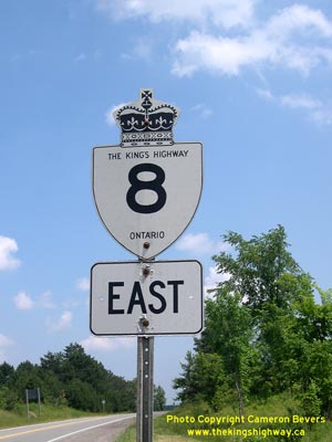
King's Highway 8 is one of the oldest provincial highways in Ontario. The route traverses a significant portion of Southern Ontario as it passes through the Counties
of Huron and Perth, the Regional Municipality of Waterloo and the City of Hamilton (formerly Wentworth County). Currently, Highway 8 extends from Goderich on the
western shores of Lake Huron to the Hamilton area. Historically, the route continued east from Hamilton to Niagara Falls. The history of Highway 8 dates back virtually to the dawn of the provincial highway network. The Department of Public Highways of Ontario (DPHO) was established by the Ontario Government in 1916 to oversee matters pertaining to road transportation. The DPHO promoted development and improvements to major trunk roads in Southern, Central and Eastern Ontario. Until 1917, however, the Province of Ontario itself did not own any highways. Roads at that time were owned by counties, townships and other municipalities. However, the increase in long-distance motorized road transportation in the first decades of the 20th Century brought about a need for the provincial government to assume trunk roads of significant importance as provincial highways. Ontario designated its first Provincial Highway between the Rouge River and Port Hope in 1917. This was followed in 1918 with the assumption of several other key roads in Ontario, including a section of road which ultimately became Highway 8. Preliminary Route Plans were prepared dated July 10, 1918, which illustrated a proposed Provincial Highway through Wentworth and Lincoln Counties. The proposed route began at the east limits of the City of Hamilton (as it existed at that time) and followed the Grimsby and Queenston Stone Roads easterly to Queenston, via Grimsby, Beamsville, St. Catharines and St. Davids. The new Hamilton-Queenston route was first assumed by the DPHO as a new provincial highway on August 15, 1918. Since the highway connected to the road system of New York State via the Queenston Heights Suspension Bridge, the Hamilton-Queenston Highway became the first international highway link ever designated in Ontario. Sections of the road passing through Beamsville, Grimsby and St. Catharines were not assumed by the DPHO and thus those sections of the route remained under municipal jurisdiction. The new Hamilton-Queenston Highway was approximately 68 km (42 miles) in length, including the municipally-owned sections within towns. In 1920, a new Provincial Highway was designated through Huron, Perth, Waterloo and Wentworth Counties. The new highway began in Goderich and continued southeasterly to Hamilton, via Clinton, Seaforth, Mitchell, Stratford and Kitchener. During May and June of 1920, Preliminary Route Plans were prepared for the various sections of this new road. The DPHO acquired the Goderich-Hamilton Road in June and July 1920, when it was assumed as an Ontario Provincial Highway. The section of the Provincial Highway within Perth County was assumed on June 24, 1920, while the balance of the highway within Huron, Waterloo and Wentworth Counties was assumed on July 8, 1920. Between Stratford and Kitchener, the route of the Goderich-Hamilton Road shared a concurrent route with the Guelph-Sarnia Road. Sections of the road passing through Goderich, Clinton, Seaforth, Mitchell, Stratford, New Hamburg, Kitchener, Preston, Galt, Dundas and Hamilton were not assumed by the DPHO and thus those sections of the route remained under municipal jurisdiction. In 1920, a branch route of the Provincial Highway was designated which extended south from the Hamilton-Queenston Highway at St. Davids to Niagara Falls. Preliminary Route Plans were prepared dated September 22, 1920, which illustrated a proposed extension of the Provincial Highway through Lincoln and Welland Counties. This south leg of the route via Niagara Falls ended at the Whirlpool Rapids Bridge and also connected to the New York State highway network. This extension to the Provincial Highway between St. Davids and Niagara Falls was assumed by the DPHO on October 13, 1920. In 1925, a route numbering system was introduced for Ontario's Provincial Highways. The existing 250 km (155 mile) route from Goderich to Niagara Falls was designated as Provincial Highway 8 in 1925, while the 4 km (2.5 mile) link from St. Davids to Queenston was designated as Provincial Highway 8A. Provincial Highway 8 ran concurrently with Provincial Highway 7 between Stratford and Kitchener, making this one of the earliest overlapped route designations in Ontario's history. Provincial Highway 8 was renamed King's Highway 8 in 1930. At the time of assumption in 1918, Highway 8 was surfaced with either gravel or water-bound macadam between Hamilton and Niagara. The road was surface-treated with oil in the summer of 1919, in order to control dust. The first concrete paving contract was completed on Highway 8 in 1922 between Hamilton and Stoney Creek, and by the end of 1923, the entire route from Hamilton to Niagara Falls was hard-surfaced. Most sections of Highway 8 from Goderich to Hamilton were surfaced with either gravel of macadam at the time of assumption in 1920. Paving work began on Highway 8 west of Dundas in 1921, and the final gravel sections between Kitchener and Hamilton were paved over in 1923. Concrete pavement was completed between Shakespeare and New Hamburg in 1924, as well as the completion of the final pavement gap between Petersburg and Kitchener. Paving work was completed between New Hamburg and Petersburg in 1925. Four miles of asphalt pavement were completed between Sebringville and Stratford in 1921. The section from Mitchell to Sebringville was paved with a bituminous surface in 1925. Six miles of concrete pavement was constructed from Goderich southeasterly in 1926, along with a section of concrete pavement between Dublin and Mitchell. Concrete pavement was completed along Highway 8 between Seaforth and Dublin in 1927. The final gravel section along Highway 8 was paved over in 1928, when a section of concrete pavement was completed between Clinton and Seaforth. Several changes were made to the route of Highway 8 through cities over the years. In Downtown Hamilton, a one-way street system was introduced in 1956 in an effort to improve traffic flow. Main Street and King Street were both converted into one-way streets. Eastbound Highway 8 retained its Main Street routing, but westbound Highway 8 traffic was moved over onto adjacent King Street. This new one-way street system came into effect on October 28, 1956. Initially, westbound Highway 8 traffic returned to join the route of Highway 8 along Main Street via Margaret Street. However, the completion of the interchange at Highway 403 in the 1960s resulted in an extension of the downtown one-way street system over to Paradise Road. In 1950, Highway 8 was rerouted through Kitchener. The highway originally entered Kitchener from Preston on King Street, and then turned west along Queen Street. At Highland Road, Highway 8 turned again and then continued westerly towards Stratford. The new route of Highway 8 through followed King Street, Ottawa Street, Courtland Avenue, and Queen Street to access Highland Road. The new route completely bypassed the congested city centre. The former route of Highway 8 through Kitchener via King Street and Queen Street was signed as Highway 8A (Alt) for a number of years in the 1950s, before the route signing was discontinued in 1960. Several diversions were built around towns along Highway 8 during the 1950s. In 1957, a new bypass was completed around New Hamburg. The old alignment of Highway 7 & Highway 8 through Downtown New Hamburg became Highway 7B & Highway 8B. Two other Highway 8B Business Routes were created in June 1959 between Galt and Dundas, when two small diversions were completed around the hamlets of Sheffield and Rockton. A new diversion of Highway 8 was constructed between St. Davids and Homer in the early 1960s. The relocated route of Highway 8 was designated as a King's Highway on August 2, 1962. The old bypassed route of Highway 8 from St. Davids to Homer was transferred by the province to the Township of Niagara on September 30, 1969. During the 1960s and early 1970s, a new system of freeways was constructed in the Kitchener-Waterloo area. The cities were bypassed by a new freeway known as the Kitchener-Waterloo Expressway (Conestoga Parkway), which looped around the southern and eastern sides of the cities. Additional improvements were also made to Highway 8 between the Kitchener-Waterloo Expressway and Preston (Cambridge) in order to improve access to Highway 401 from Kitchener-Waterloo. A new four-lane freeway, known initially as the Freeport Diversion, was constructed in several stages beginning in 1959. This new highway curved away from Highway 8 (King Street) between Franklin Street and Block Line Road (today's Fairway Road) and crossed the nearby Grand River on an entirely new controlled-access alignment. A partial interchange was built at the new Highway 8 (Freeport Diversion) and Block Line Road. When it opened to traffic in 1963, the Freeport Diversion tied into King Street about 1 km south of the Freeport Bridge on existing Highway 8. In 1985, construction got underway on an extension of the Freeport Diversion from King Street to Highway 401. This new section of the Freeport Diversion opened to traffic in November, 1987. The new route provided a fully controlled-access highway between Highway 401 and the Kitchener-Waterloo Expressway. As part of the construction of the Kitchener-Waterloo Expressway around Kitchener-Waterloo, Highway 8 was reconstructed as a freeway from just south of Franklin Street to a point just north of the Kitchener-Waterloo Expressway Interchange at Montgomery Road during 1966 and 1967. Since the project involved the construction of a section of depressed freeway along the existing route of Highway 8 approaching Franklin Street, Highway 8 traffic was temporarily rerouted along Fairway Road, Mill Street, and Henry Strum Boulevard. This latter road was a truck bypass constructed by the City of Kitchener that linked Highland Road to Courtland Avenue. The route of Henry Strum Boulevard was absorbed into route of the Kitchener-Waterloo Expressway in the late 1960s. The new freeway route of Highway 8 between Franklin Street and Montgomery Road was completed in October, 1967. Highway 8 was relocated onto the Kitchener-Waterloo Expressway between King Street and Homer Watson Boulevard when that section of the freeway opened to traffic in 1969. During the 1970s, the province studied the construction of a possible bypass around the south and west sides of Cambridge. This proposed Highway 8 Bypass would have connected to the Freeport Diversion between Preston and Kitchener and looped around Preston and Galt. The Highway 8 Bypass would have connected into the existing route of Highway 8 just south of Galt near Branchton. The Ministry of Transportation shelved the plans for the Highway 8 Bypass during the 1990s, so it is unlikely at this point that the route will ever be built. Work began in 1970 to extend the Kitchener-Waterloo Expressway westerly from Homer Watson Boulevard to Fischer Road (today's Fischer-Hallman Road). The following year, construction began on a new diversion of Highway 7 & Highway 8 from the western end of the Kitchener-Waterloo Expressway westerly to New Hamburg. This diversion was built as a staged freeway on a new alignment, so that it could be widened to a four-lane facility at a later date. This new route was ultimately converted to a freeway between 1992 and 1995. The Kitchener-Waterloo Expressway was completed to Fischer Road in 1971, but it wasn't until 1973 that the new diversion around Baden and New Hamburg was completed and opened to traffic. Upon completion of the New Hamburg-Baden Diversion in 1973, the route of Highway 7 & Highway 8 was relocated onto the new alignment from Homer Watson Boulevard out to New Hamburg. The old alignment of Highway 7 & Highway 8 via Highland Road between the old City of Kitchener Limits at Fischer Road and Wilson Road (today's West Acres Crescent) was transferred from the province to the City of Kitchener on October 1, 1971. The balance of the old route of Highway 7 & Highway 8 via Highland Road & Snyder's Road from Kitchener westerly to the New Hamburg-Baden Diversion was transferred to the newly-formed Regional Municipality of Waterloo on October 7, 1975. The old route of Highway 7 & Highway 8 was briefly signed as Highway 7B & Highway 8B between 1973 and 1975. By the mid-1960s, the Ontario Government was systematically reviewing the provincial highway network. The goal was to identify highways which required further improvement along with identifying those highways whose purpose had been supplanted by other parallel routes. In a 1964 report, the Department of Highways concluded that the once-important route of Highway 8 between Hamilton and Niagara Falls was no longer functioning as a long-distance through highway. Traffic had fallen precipitously along this section of Highway 8 once the Queen Elizabeth Way was completed and officially opened to traffic in 1940. Since that time, Highway 8 served predominantly a local function. Most through traffic between Hamilton and Niagara Falls used the Queen Elizabeth Way. It was decided that the route of Highway 8 was no longer needed in the provincial highway system, as it was essentially redundant. The route of Highway 8 was decommissioned in several sections, beginning in 1967. The first 3 km section of Highway 8 to be transferred ran from the corner of Stanley Avenue and Thorold Stone Road (the old Niagara Falls City Limits) to Mountain Road, just south of Highway 405. This section of Highway 8 was transferred to the City of Niagara Falls on September 21, 1967. The route of Highway 8 from that point easterly to the Niagara River had always been under the jurisdiction of the municipality. Another 1 km section of Highway 8 from Mountain Road to Highway 405 was transferred to the City of Niagara Falls on November 9, 1968. The remainder of the old, winding route of Highway 8 between the Wentworth-Lincoln County Boundary near Winona to Highway 405 was transferred to the newly-established Regional Municipality of Niagara, effective September 1, 1970. Today, this section of Former Highway 8 through Niagara Region is known as Niagara Road 81, Niagara Road 100, Thorold Stone Road, Stanley Avenue and Bridge Street. During the late 1990s, additional sections of Highway 8 were transferred from the province to municipal road authorities. On March 31, 1997, the portion of Highway 8 from the Highway 5 Junction at Peters Corners to the Hamilton-Wentworth Boundary near Winona was turned over to the Regional Municipality of Hamilton-Wentworth. This also resulted in the discontinuation of the municipal connecting link portions of Highway 8 running through Stoney Creek, Hamilton and Dundas. Another provincially-owned section of Highway 8 (King Street) between Freeport and Highway 401 was transferred to the Regional Municipality of Waterloo on March 31, 1997. The transfer of King Street added to the municipally-owned section of Highway 8 running through the City of Cambridge, which was not assumed by the province. Thus, the entire section of Highway 8 from Freeport to the south Cambridge City Limits is now maintained by the Regional Municipality of Waterloo. As a result of these municipal transfers during the 1970s and 1990s, the length of Highway 8 was reduced by about 100 km. Today. Highway 8 is approximately 154 km in length, including the non-assumed portion of the highway within the City of Cambridge. Growing traffic volumes in the Kitchener-Waterloo area have led to several recent upgrades to Highway 8. The problematic partial cloverleaf interchange connecting Highway 8 to the Kitchener-Waterloo Expressway (Highway 7 & Highway 8) was rebuilt between 2002 and 2004. As part of this project, Highway 8 was expanded from four to eight lanes from the Kitchener-Waterloo Expressway Interchange to the Franklin Street Overpass. However, the highlight of this project was the construction of a new flyover connecting westbound Highway 7 to eastbound Highway 8. The new flyover was completed and opened to traffic in June 2004, finally eliminating one of Southern Ontario's worst traffic bottlenecks. Between 2006 and 2012, the portion of Highway 8 from the Franklin Street Overpass to the King Street Underpass near Freeport was reconstructed to provide eight through lanes. The remainder of Highway 8 from the King Street Underpass to Sportsworld Drive was widened to six through lanes as part of this expansion project. In 2012, construction got underway to widen the Kitchener-Waterloo Expressway (Highway 7 & Highway 8) to six lanes between Courtland Avenue and Fischer-Hallman Road. Construction was completed in late 2016. In 2012, the awkward "triple crossroads" intersection at Peters Corners was completely reconstructed. Highway 8 was realigned so that it met Highway 52 at a four-leg modern roundabout. The eastern leg of Former Highway 8 leading into Dundas was also realigned in order to separate it from the new roundabout. The new Peters Corners Roundabout was the very first multi-lane modern roundabout ever built on an Ontario provincial highway, and only the third roundabout completed on the provincial highway system. The new Peters Corners Roundabout was officially opened to traffic on October 4, 2012, although eastbound Highway 8 traffic had been using a portion of the roundabout's circulatory roadway since September 15, 2012, due to construction staging. As a result of the highway realignment at Peters Corners, Highway 5 and Highway 8 are now signed concurrently for about 250 metres. This was done to connect the realigned route of Highway 8 coming from Cambridge with Former Highway 8 leading to Dundas. Highway 8 traverses a predominantly rural portion of Southern Ontario, although it does pass through several large cities and towns along its route. The principal towns located along Highway 8 are Goderich, Clinton, Mitchell, Stratford, Kitchener and Cambridge. A 45 km section of Highway 8 is signed concurrently with Highway 7 between Kitchener and Stratford. Most sections of Highway 8 are two lanes, but a 22 km section of the highway is now a controlled-access freeway. The freeway section of Highway 8 begins near Baden and continues easterly to Highway 401 in Cambridge. The rural section of this freeway is mostly four lanes, but the urban sections have recently been widened to either six or eight lanes. There are also some undivided four-lane sections through towns and cities along the highway's 154 km route. Services along Highway 8 are generally quite plentiful. The speed limit on Highway 8 is 80 km/h (50 mph), unless posted otherwise. Most of freeway sections of Highway 8 are posted at 90 km/h (55 mph), although one section near Highway 401 is posted at 100 km/h (60 mph). Please visit the Highway 8 Mileage Chart page for a list of mileage reference points along Highway 8. Winter Driving Tip: The western section of Highway 8 is known for poor winter road conditions. The highway is sometimes closed during periods of poor winter weather between Stratford and Goderich, due to blowing and drifting snow. Blowing snow will often result in zero-visibility conditions. The weather conditions on this highway can deteriorate very rapidly when snow squalls blow in from nearby Lake Huron. On cold, windy days, it is a good idea to check the Ontario Ministry of Transportation's Winter Road Conditions and Road Closures reported on the Ontario 511 website before using the western portion of Highway 8. 

 |
|---|
Additional Information About King's Highway 8:
King's Highway 8 - Route Information (At Scott Steeves' website: asphaltplanet.ca)
King's Highway 8 - A Virtual Tour (At Scott Steeves' website: asphaltplanet.ca) |
|---|
Links to Adjacent King's Highway Pages: 


Website contents, photos & text © 2002-2025, Cameron
Bevers (Webmaster) - All Rights Reserved / Contact Me |
|---|