| 
| |
|
|
This page contains historical and present day photos of Ontario's King's Highway 109 (#1), which ran from Dawes Road easterly
to Highway 2 in the Toronto area. All photographs displayed on this page were taken by the Webmaster (Cameron Bevers), unless specifically noted otherwise.
Historical photographs are arranged in approximate chronological order, while present day photographs (Year 2000 to date) are arranged by location from west to
east. Click on any thumbnail to see a larger image!
Please note that all photographs displayed on this
website are protected by copyright. These photographs must not be reproduced, published,
electronically stored or copied, distributed, or posted onto other websites without
my written permission. If you want to use photos from this website, please
email me first for permission. Thank-you!
|
|---|
|
Historical King's Highway 109 (#1) Photographs

Above - View of Hwy 5A (Eglinton Avenue East) in Scarborough Township in 1949. This section of Hwy 5A was renumbered as Hwy 109 in 1953. (Photo courtesy of Ontario Ministry of Transportation - © King's Printer for Ontario, 1949) 
Left - Aerial view of Hwy 5A (Eglinton Avenue East) in 1949, facing east from Dawes Road (today's Victoria Park Avenue). This photo shows the western terminus
of Hwy 5A at Dawes Road in Scarborough Township. The section of Eglinton Avenue East from this point easterly to Hwy 2 (Kingston Road) was an assumed provincial
highway, under the jurisdiction of the Ontario Department of Highways. Up until 1952, a discontinuous west section of Hwy 5A ran along St. Clair Avenue and Dundas
Street from the Hwy 5 Junction at Bloor Street easterly to Hwy 11 (Yonge Street). However, the eastern and western legs of Hwy 5A never actually connected, since
Eglinton Avenue did not continue across the Don River. Based on land plans registered prior to World War II, it appears that planning was underway to link the eastern
and western legs of Hwy 5A by extending the highway along Eglinton Avenue through Leaside. The completion of Hwy 5A across the Don River would have provided an
alternate route for traffic wishing to bypass Downtown Toronto. However, these plans never came to fruition, presumably due to the outbreak of war in 1939. By the
time World War II ended in 1945, the Department of Highways was already studying plans for a new Toronto Bypass (today's Hwy 401) which would be built around the
north limits of Toronto. As a result, the route of Hwy 5A (which was renumbered as Hwy 109 in the early 1950s) was considered superfluous to the needs of the overall
provincial highway network. The highway was eventually decommissioned in 1954, shortly after the creation of Metropolitan Toronto. Ultimately, the extension of
Eglinton Avenue between Leaside and Dawes Road was completed under the jurisdiction of Metropolitan Toronto in 1956. See an
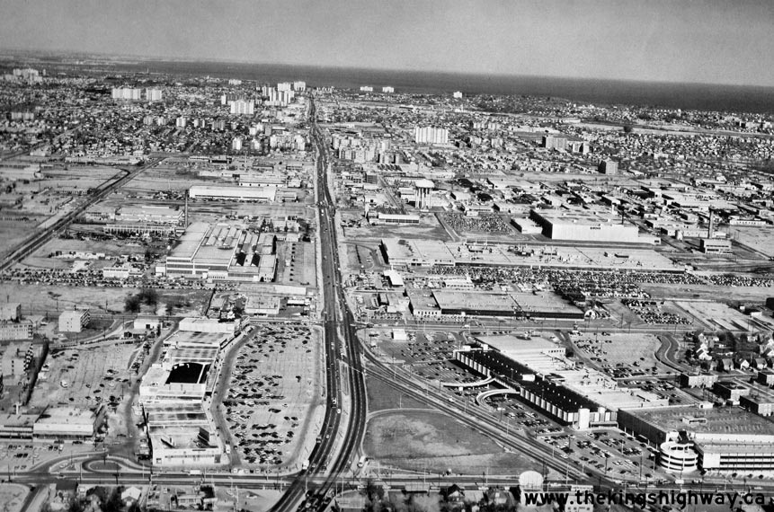
Enlarged Photo here. Photo taken in December, 1949. (Photo courtesy of Lockwood Survey Corporation) Right - Aerial view of Former Hwy 5A (Hwy 109) in 1969, facing east from Victoria Park Avenue in Toronto. Compare this 1969 photo to the 1949 photo above, showing the incredible growth of Scarborough over the previous two decades. See an Enlarged Photo here. (Photo courtesy of Lockwood Survey Corporation)
More King's Highway 109 (#1) Photographs Coming Soon!
|
|---|
Links to Adjacent King's Highway Photograph Pages:
Back to King's Highway 108 (#2) Photos /
King's Highway 109 (#1) History /
On to King's Highway 109 (#2) Photos
Ontario Highway History - Main Menu / Back to List of Highways Website contents, photos & text © 2002-2026, Cameron
Bevers (Webmaster) - All Rights Reserved / Contact Me
|
|---|