
| 
| |
|
|
This page contains historical photos of Ontario's King's Highway 10 dating from 1920 to 1979. All photographs displayed on
this page were taken by the Ontario Ministry of Transportation, unless specifically noted otherwise. Historical photographs are arranged in approximate chronological
order. Click on any thumbnail to see a larger image!
Please note that all photographs displayed on this
website are protected by copyright. These photographs must not be reproduced, published,
electronically stored or copied, distributed, or posted onto other websites without
my written permission. If you want to use photos from this website, please
email me first for permission. Thank-you!
|
|---|
|
Page 1: Historical King's Highway 10 Photographs (1920-1979)

Above - Circa 1928 view of the Hwy 5 & Hwy 10 Junction (Dundas Street and Hurontario Street) at Cooksville, north of Port Credit. This fantastic photo from
the late 1920s shows the junction of these two important Provincial Highways just west of Toronto. In the early days of Ontario's highway system, virtually all
traffic headed to Southwestern Ontario from Toronto flowed through this highway junction. Before construction of superhighways such as the Queen Elizabeth Way and
Hwy 401, the "Dundas Highway" (Hwy 5) was the preferred route to the west for many motorists. Not only was this route very direct, but it also served as a convenient
bypass for the numerous villages and towns along Lake Ontario's northern shoreline, where through traffic was regularly snarled along the old Toronto-Hamilton Highway
(Hwy 2). It wasn't long before enterprising individuals built services such as gas stations and restaurants at Cooksville to cater to the burgeoning clientele of
motorists who passed through this important highway junction. As a footnote to other historical researchers, the original print of this photo at Archives of Ontario
was marked as being circa 1919. Based on the Provincial Highway signs visible in the photo and other improvements made to the highway, it must date between 1925 and
1930. I have dated the photo to approximately 1928. Although not noted on the photo, I believe that this view is facing east along Hwy 5 from Cooksville towards
Toronto. See an Enlarged Photo Here. (Photo © Archives of Ontario - Series RG-14-162-2-64, Box B982) 

Left - New mixed macadam pavement and traffic warning signs on Hwy 10 at Sligo Hill south of Caledon, Contract #1928-68. See an
Enlarged Photo Here. Photo taken in 1928. (Photo courtesy of Ontario Ministry of Transportation - © King's Printer for Ontario, 1928) Right - Junction of Hwy 7 & Hwy 10 at Westervelt Corners north of Brampton, facing south along Hurontario Street in 1930. This photo shows the original directional "Y" intersection at the Hwy 7 & Hwy 10 Junction north of Brampton. For many years, Hwy 7 & Hwy 10 shared a short concurrent routing between this highway junction at Westervelt Corners (located at the present-day intersection of Bovaird Drive & Hurontario Street) and Downtown Brampton. The two highways shared this route from the time route numbers were first introduced on Ontario Highways in 1925 up until the early 1980s, when Hwy 7 was rerouted along Bovaird Drive and the newly-built Hwy 410. Note the pre-King's Highway triangular Ontario Provincial Highway signs and the unusual square "STOP" sign at right. Compare this 1930 photo to this 2004 photo of the same intersection. See an Enlarged Photo Here. Photo taken in 1930. (Photo © Archives of Ontario - Series RG-14-162-2, Volume #1) 
Above - View of the Port Credit Cloverleaf at Middle Road (Queen Elizabeth Way) and Hwy 10 in 1938, facing northwest. See an
Enlarged Photo Here. Photo taken on December 10, 1938. (Photo courtesy of Ontario Ministry of Transportation - © King's Printer for Ontario, 1938) 
Above - Night view of the Port Credit Cloverleaf at Hwy 10 and the Middle Road in 1938, showing the new High-Pressure Sodium (HPS) illumination system at
Canada's first grade-separated full cloverleaf interchange. Illumination was installed at the Port Credit and Burlington Interchanges in 1937, along with a 4-mile
section of the Middle Road between Toronto and Port Credit. A continuous illumination system was installed along the entire length of the dual highway between Toronto
and Niagara Falls by 1941. See an Enlarged Photo Here. Photo taken in 1938. (Photo courtesy of Ontario Ministry of Transportation - © King's Printer for Ontario, 1938) 
Above - View of the Middle Road Superhighway facing west towards Hamilton from the Hwy 10 Cloverleaf at Port Credit in 1939. This fantastic centreline photo of
the new superhighway was taken about 18 months after the Port Credit Cloverleaf was completed and opened to traffic on November 21, 1937. The cloverleaf carried
Hwy 10 traffic safely across the Middle Road. This was the first cloverleaf interchange ever built in Canada. Very few jurisdictions had ever built a high-speed
motorway when this cloverleaf was designed in 1937, and that lack of design experience led to problems with the interchange that, in hindsight, one might view as
obvious. Note that ramp traffic had to stop and wait at the end of the ramps for gaps in traffic before entering the superhighway, as there were no speed change lanes
beyond the ramp entrances. It was assumed (perhaps naively) that motorists would be courteous enough to allow entering traffic to merge and that traffic volumes would
remain low enough that lane changes could take place easily. However, as this photo clearly demonstrates, the superhighway was already getting quite busy even before
World War II. This photo wasn't taken on a weekday either - it was taken on a Sunday evening! Three days after this photo was taken, the Middle Road was officially
rededicated as the "Queen Elizabeth Way". See an Enlarged Photo Here. Photo taken on June 4,
1939. (Photo © Archives of Ontario - Series RG-14-162-3, Cont. A1352, Photo #113B) 
Above - Aerial view of the Port Credit Cloverleaf on the Queen Elizabeth Way at Hwy 10 (Hurontario Street), facing east towards Toronto in 1944. See an
Enlarged Photo Here. Photo taken in 1944. (Photo © Archives of Ontario - Series RG-14-162-5-166, Box B1038, Photo #972-31) 
Above - Looking west along the Queen Elizabeth Way towards Oakville at the Hwy 10 Cloverleaf at Port Credit. See an
Enlarged Photo Here. Photo taken on May 10, 1947. (Photo © Archives of Ontario - RG-14-162-3, Cont. A1367, Photo #6652) 
Above - Switchback on Hwy 10 at Sligo Hill south of Caledon Village, prior to reconstruction under Contract #1949-16. This reverse curve allowed Hwy 10 to
climb up a steep grade about 3 miles south of Caledon Village. About 1 mile of the highway was reconstructed in 1949-1950 in order to remove the sharp curves of the
switchback and straighten the alignment of Hwy 10 on an improved grade. See an
Enlarged Photo Here. Photo taken on June 16, 1949. (Photo © Archives of Ontario - Series RG-14-162-5-121, Photo #169A) 

Left - Grading of Sligo Hill on Hwy 10 south of Caledon Village in 1949, under Contract #1949-16. Note the original switchback in the background of this photo,
which was removed during a major highway reconstruction project in 1949-1950. The removal of the Sligo Hill Switchback was a key step in the modernization of Hwy 10
between Brampton and Owen Sound. Photo taken on August 24, 1949. (Photo courtesy of Ontario Ministry of Transportation - © King's Printer for Ontario, 1949) Right - Origin-Destination Traffic Survey on Hwy 10 north of Brampton in 1950. Surveys such as this one were carried out all across Ontario during the 1940s and 1950s by the Ontario Department of Highways, in order to get a better understanding of motorists' travel patterns across Ontario. These "O-D Surveys" proved to be very beneficial to the Department of Highways in the planning for new highways and to prioritize expansion and reconstruction of existing highways. (Photo courtesy of Ontario Ministry of Transportation - © King's Printer for Ontario, 1950) 

Left - Revised grade on Sligo Hill south of Caledon after reconstruction in 1949-1950. Note that the old switchback has been removed. Photo taken on July 7,
1950. (Photo courtesy of Ontario Ministry of Transportation - © King's Printer for Ontario, 1950) Right - Completed asphalt pavement and zone striping following the reconstruction of Hwy 10 at Sligo Hill south of Caledon Village. Photo taken on July 20, 1951. (Photo courtesy of Ontario Ministry of Transportation - © King's Printer for Ontario, 1951) 

Left - Owen Sound District Garage and Paint Shop. Photo taken on October 29, 1952. (Photo courtesy of Ontario Ministry of Transportation - © King's Printer for Ontario, 1952) Right - Highway sign storage room at the Owen Sound District Garage in 1952. Note the "Junction" sign for Hwy 6 & Hwy 21 leaning against the wall. Despite the widespread downloading of Ontario's King's Highways in the 1990s, the overlapped route of Hwy 6 & Hwy 21 still remains intact today between Springmount and Owen Sound. Photo taken on October 29, 1952. (Photo courtesy of Ontario Ministry of Transportation - © King's Printer for Ontario, 1952) 
Above - Postcard view of the Hwy 4 & Hwy 10 Junction in Downtown Flesherton (ca. 1955) (Photo from Cameron Bevers' historical photograph collection - Original photographer unknown) 
Above - New hot-mix asphalt paving and zone striping on Hwy 10 constructed under Contract #1954-404, 3 miles north of Shelburne. See an
Enlarged Photo Here. Photo taken in 1955. (Photo courtesy of Ontario Ministry of Transportation - © King's Printer for Ontario, 1955) 
Above - Circa 1958 postcard view of Hwy 6 & Hwy 10 (2nd Avenue) in Downtown Owen Sound, facing north. See an
Enlarged Photo Here. (Photo courtesy of Canadian Postcard Company Ltd, Toronto) 

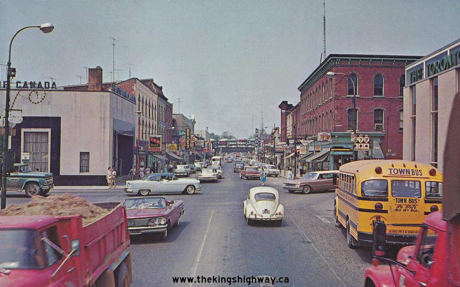
Left - Facing south along Queen Street (Hwy 10) in Downtown Brampton (1957) (Photo courtesy of Ontario Ministry of Transportation - © King's Printer for Ontario, 1957) Right - Grading operations on Hwy 10 & Hwy 24, five miles south of Primrose (1960) (Photo courtesy of Ontario Ministry of Transportation - © King's Printer for Ontario, 1960) 
Above - Postcard view of the Hwy 7 & Hwy 10 Junction in Downtown Brampton in 1963, facing north. See an
Enlarged Photo Here. (Photo courtesy of R. Gordon Robinson) 

Left - Reconstruction and widening of Hwy 10 north of Brampton, Contract #1964-363. See an
Enlarged Photo Here. Photo taken in 1965. (Photo courtesy of Ontario Ministry of Transportation - © King's Printer for Ontario, 1965) Right - Completed resurfacing along Hwy 10 between Shelburne and Melancthon. See an Enlarged Photo Here. Photo taken in 1965. (Photo courtesy of Ontario Ministry of Transportation - © King's Printer for Ontario, 1965) 

Left - Facing south along Hwy 10 towards Main Street in Markdale. See an
Enlarged Photo Here. Photo taken in 1967. (Photo courtesy of Ontario Ministry of Transportation - © King's Printer for Ontario, 1967) Right - View of Hwy 10 at Markdale, facing south near Mark Street. See an Enlarged Photo Here. Photo taken in 1967. (Photo courtesy of Ontario Ministry of Transportation - © King's Printer for Ontario, 1967) 

Left - Facing north along Hwy 10 towards Owen Sound from the Hwy 4 Junction in Flesherton. See an
Enlarged Photo Here. Photo taken in 1967. (Photo courtesy of Ontario Ministry of Transportation - © King's Printer for Ontario, 1967) Right - View of Hwy 10 facing south from the Hwy 4 Junction in Flesherton. See an Enlarged Photo Here. Photo taken in 1967. (Photo courtesy of Ontario Ministry of Transportation - © King's Printer for Ontario, 1967) 
Above - Facing south along Hwy 10 towards the Hwy 4 Junction in Flesherton. See an
Enlarged Photo Here. Photo taken in 1967. (Photo courtesy of Ontario Ministry of Transportation - © King's Printer for Ontario, 1967) 

Left - Facing north along Hwy 10 & Hwy 24 towards Orangeville at the Credit River Bridge south of the Hwy 9 Junction. See an
Enlarged Photo Here. Photo taken in July 1967. (Photo courtesy of Ontario Ministry of Transportation - © King's Printer for Ontario, 2013) Right - Credit River Bridge on Hwy 10 & Hwy 24, south of the Hwy 9 Junction near Orangeville. Photo taken in July 1967. (Photo courtesy of Ontario Ministry of Transportation - © King's Printer for Ontario, 2013) 

Left - Facing north along Hwy 10 & Hwy 24 towards Orangeville at the Credit River Bridge north of Caledon Village. Note the dual Hwy 10 & Hwy 24 route
markers in the background. These two highways shared a common route between Caledon Village and Shelburne up until 1998, when the northern section of Hwy 24 was
downloaded to the Counties of Simcoe, Grey and Dufferin. This section of Hwy 10 was recently widened to a four-lane highway with a continuous two-way centre left turn
lane. See an Enlarged Photo Here. Photo taken in July 1967. (Photo courtesy of Ontario Ministry of Transportation - © King's Printer for Ontario, 2013) Right - Credit River Bridge on Hwy 10 & Hwy 24 north of Caledon Village. Photo taken in July 1967. (Photo courtesy of Ontario Ministry of Transportation - © King's Printer for Ontario, 2013) 

Left - Hwy 10 (Hurontario Street) Cloverleaf on Hwy 401 west of Toronto. See an
Enlarged Photo Here. Photo taken in October 1968. (Photo courtesy of Ontario Ministry of Transportation - © King's Printer for Ontario, 2013) Right - Facing north along Hwy 10 towards Brampton from the Hwy 401 Interchange. See an Enlarged Photo Here. Photo taken in October 1968. (Photo courtesy of Ontario Ministry of Transportation - © King's Printer for Ontario, 2013) 

Left - New Rocky Saugeen River Culvert on Hwy 10 near Markdale, Contract #1967-74. See an
Enlarged Photo Here. Photo taken in 1968. (Photo courtesy of Ontario Ministry of Transportation - © King's Printer for Ontario, 1968) Right - Reconstruction and widening of Hwy 10 to four lanes between Victoria and Caledon Village, Contract #1969-11. This photo is rather interesting, as it shows a historical construction practice which is no longer permitted. One would just never see live traffic on a highway travelling this close to an open excavation on a modern highway construction project. Careful consideration goes into the design of construction zones today to ensure the safety of both construction workers as well as the travelling public. See an Enlarged Photo Here. Photo taken in 1969. (Photo courtesy of Ontario Ministry of Transportation - © King's Printer for Ontario, 1969) 
Above - Aerial view of the completed Orangeville Bypass in 1971, facing north from the Hwy 9 Junction. Constructed under Contract #1970-03, the Orangeville
Bypass allowed through traffic on Hwy 10 & Hwy 24 to avoid the congested town centre. The Orangeville Bypass was a crowning achievement in a series of highway
improvements completed along Hwy 10 after World War II. See an Enlarged Photo Here. Photo taken
in 1971. (Photo courtesy of Ontario Ministry of Transportation - © King's Printer for Ontario, 1971) 

Left - Facing south along Hwy 10 towards Brampton at the Inglewood Creek Bridge. Photo taken on October 23, 1971. (Photo courtesy of Ontario Ministry of Transportation - © King's Printer for Ontario, 2013) Right - Inglewood Creek Bridge on Hwy 10 south of Caledon Village. Photo taken on October 23, 1971. (Photo courtesy of Ontario Ministry of Transportation - © King's Printer for Ontario, 2013) 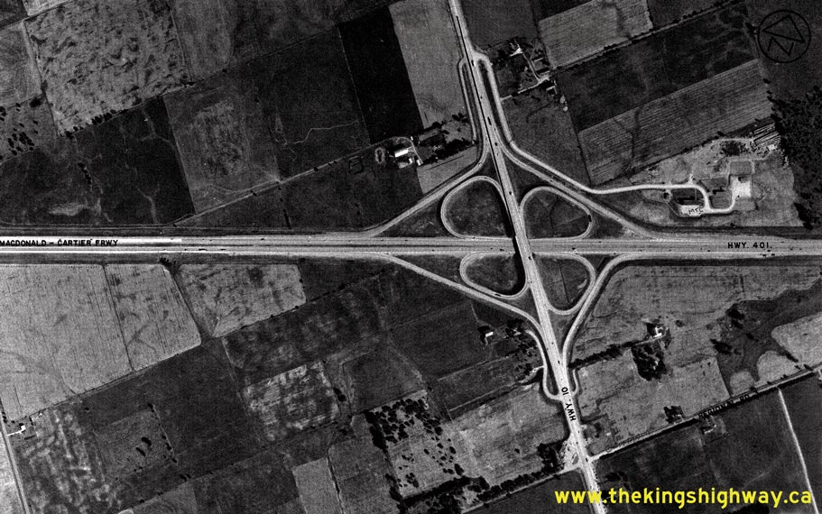
Above - Aerial view of the Hwy 10 Interchange on Hwy 401 between Port Credit and Brampton in 1974. The Hwy 10 Interchange was originally constructed in 1957
as a full eight-ramp cloverleaf. In 1975-1976, the two far-side loop ramps were removed, creating a "Parclo A-4" interchange that stood until 2009-2010, when the
interchange was reconstructed again. The lack of development around the interchange at the time this photo was taken is quite remarkable - it certainly doesn't look
like this today. See an Enlarged Photo Here. Photo taken in 1974. (Photo courtesy of Ontario Ministry of Transportation - © King's Printer for Ontario, 2013) 
Above - Facing north along Hwy 10 at the Cooksville CP Railway Subway north of Hwy 5 (Dundas Street). See an
Enlarged Photo Here. Photo taken on October 21, 1977. (Photo courtesy of Ontario Ministry of Transportation - © King's Printer for Ontario, 2013) 
Above - Cooksville CP Railway Subway on Hwy 10 north of Dundas Street, facing west. This part of Mississauga is now quite urbanized. Photo taken on October 21,
1977. (Photo courtesy of Ontario Ministry of Transportation - © King's Printer for Ontario, 2013) 
Above - Approaching the Hwy 10 & Hwy 24 Junction on Hwy 9 in Orangeville in 1977. Note the green guide sign at right, showing the concurrent routes of
Hwy 9, Hwy 10 and Hwy 24. Until the Orangeville sections of Hwy 9 and Hwy 24 were downloaded in 1998, this highway junction represented a rare situation where three
King's Highways shared a concurrent route. See an Enlarged Photo Here. Photo taken in November
1977. (Photo courtesy of Ontario Ministry of Transportation - © King's Printer for Ontario, 2012) 
Above - Credit River Bridge on Hwy 10 & Hwy 24, south of the Hwy 9 Junction near Orangeville. Photo taken on July 27, 1978. (Photo courtesy of Ontario Ministry of Transportation - © King's Printer for Ontario, 2013)
Continue on to King's Highway 10 Photos: Historical Photos: 1980 to 1999
|
|---|
Links to Adjacent King's Highway Photograph Pages:
Back to King's Highway 9 Photos /
King's Highway 10 History /
On to King's Highway 11 Photos
Ontario Highway History - Main Menu / Back to List of Highways Website contents, photos & text © 2002-2026, Cameron
Bevers (Webmaster) - All Rights Reserved / Contact Me
|
|---|