
| 
| |
|
|
This page contains present day photos (Year 2000 to date) of Ontario's King's Highway 10, arranged by location from Caledon
northerly to Shelburne. All photographs displayed on this page were taken by the Webmaster (Cameron Bevers), unless specifically noted otherwise. Click on any
thumbnail to see a larger image!
Please note that all photographs displayed on this
website are protected by copyright. These photographs must not be reproduced, published,
electronically stored or copied, distributed, or posted onto other websites without
my written permission. If you want to use photos from this website, please
email me first for permission. Thank-you!
|
|---|
|
Page 4: Present Day King's Highway 10 Photographs (Caledon to Shelburne)


Left - Facing north along Hwy 10 & Hwy 24 towards Orangeville from Caledon Village. A northbound passing lane used to develop just a short distance north
of town and continue up the long grade to Beechgrove Sideroad. This photo was taken before the highway was expanded to four lanes in 2008-2009. See an
Enlarged Photo here. (Photograph taken on September 8, 2007 - © Cameron Bevers) Right - Approaching Caledon Village on Hwy 10 & Hwy 24, facing south. The northbound passing lane can be seen at left. See an Enlarged Photo here. (Photograph taken on September 8, 2007 - © Cameron Bevers) 

Left - Facing north along Hwy 10 & Hwy 24 towards Orangeville between Caledon Village and Beechgrove Sideroad. The northbound passing lane at right was
incorporated into the widened four-lane highway in 2008-2009. A two-way centre left turn lane was also built along the highway during the widening project. See an
Enlarged Photo here. (Photograph taken on September 8, 2007 - © Cameron Bevers) Right - Hwy 10 & Hwy 24 at Beechgrove Sideroad before widening, facing south towards Caledon Village. See an Enlarged Photo here. (Photograph taken on September 8, 2007 - © Cameron Bevers) 

Left - The northbound passing lane on Hwy 10 & Hwy 24 terminated just beyond the crest of the grade at Beechgrove Sideroad. As a result of the highway
widening project in 2008-2009, this second northbound lane now continues all the way through to Orangeville. See an
Enlarged Photo here. (Photograph taken on September 8, 2007 - © Cameron Bevers) Right - Facing north along Hwy 10 & Hwy 24 north of Beechgrove Sideroad prior to widening. Until quite recently, the majority of the highway between Caledon Village and Orangeville was only two lanes. The highway expansion project in 2008-2009 added a second lane in each direction, plus a two-way centre left turn lane to provide improved access to the driveways and commercial entrances along the highway. See an Enlarged Photo here. (Photograph taken on September 8, 2007 - © Cameron Bevers) 

Left - View of Hwy 10 & Hwy 24, facing north towards Orangeville north of Beechgrove Sideroad. This photo was taken before the highway was expanded to four
lanes in 2008-2009. A southbound passing lane can be seen terminating in the distance at left. See an
Enlarged Photo here. (Photograph taken on September 8, 2007 - © Cameron Bevers) Right - Southbound passing lane on Hwy 10 & Hwy 24 prior to widening, facing north towards Orangeville. This long passing lane ascends the long grade south of the Credit River Bridge. As with the nearby northbound passing lane, this third lane was incorporated into the widened four-lane highway in 2008-2009. See an Enlarged Photo here. (Photograph taken on September 8, 2007 - © Cameron Bevers) 

Left - Facing south along Hwy 10 & Hwy 24 towards Caledon Village near Highpoint Sideroad. In the late 1950s, a major revision was made to the vertical
alignment of Hwy 10 at this location. Originally, the highway used to dip down into this valley. Heading northbound, the highway climbed a steep uphill grade before
descending once again towards the Credit River. A large earth cut was made near Highpoint Sideroad, and the excavated earth was deposited into the adjacent valley in
order to flatten out the profile of the highway. Note the long earth fill that the highway sits upon - an astonishing amount of earth was moved in order to build the
highway that we see here today! See an Enlarged Photo here. (Photograph taken on September 8, 2007 - © Cameron Bevers) Right - A large earth cut on Hwy 10 & Hwy 24, facing north near Highpoint Sideroad. The earth excavated from this cut was used as fill material in an adjacent valley in order to smooth out the highway's vertical alignment. This made Hwy 10 more manageable for heavy truck traffic, which previously had difficulties ascending the old highway's steep grades. See an Enlarged Photo here. (Photograph taken on September 8, 2007 - © Cameron Bevers) 

Left - Facing north along Hwy 10 & Hwy 24 towards Orangeville near Highpoint Sideroad north of Caledon Village. Despite the revisions made to the vertical
alignment of Hwy 10 during the 1950s, there are still some significant grades along the highway in the Caledon area. See an
Enlarged Photo here. (Photograph taken on September 8, 2007 - © Cameron Bevers) Right - Approaching the Credit River on Hwy 10 & Hwy 24, facing north towards Orangeville. See an Enlarged Photo here. (Photograph taken on September 8, 2007 - © Cameron Bevers) 

Left - Facing north along Hwy 10 & Hwy 24 towards Orangeville from the south junction of Highpoint Sideroad. Due to the steep grades in the area, there are
two intersections for Highpoint Sideroad, offset by about 300 metres. Prior to the highway widening, a fully mountable concrete curb extended right through both
intersections of Highpoint Sideroad. This is a very unusual drainage design for the intersection of a King's Highway and another public road. Typically, curbs are not
carried through an intersection like this. However, this section of Hwy 10 was last reconstructed in the 1950s, at a time where highway designers were still
experimenting with various types of roadway drainage systems along provincial highways. The curb and gutter system seen here was replaced during the highway widening
project in 2008-2009. See an Enlarged Photo here. (Photograph taken on September 8, 2007 - © Cameron Bevers) Right - Intersection of Highpoint Sideroad on Hwy 10 & Hwy 24, facing south towards Caledon Village. Note the old fully mountable concrete curb and gutter system which was carried through the intersection. A more conventional intersection design was built here during the highway expansion project in 2008-2009. See an Enlarged Photo here. (Photograph taken on September 8, 2007 - © Cameron Bevers) 

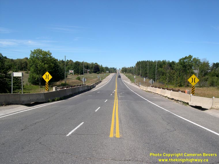
Left - Hwy 10 & Hwy 24 approaching the Credit River Bridge north of Caledon Village, facing north. See an
Enlarged Photo here. (Photograph taken on September 8, 2007 - © Cameron Bevers) Right - Facing south along Hwy 10 & Hwy 24 towards Caledon Village from the Credit River Bridge. A southbound passing lane begins at the Credit River and continues up the grade to the Beechgrove Sideroad area. When the highway was widened to four lanes in 2008-2009, this passing lane was incorporated into the widened highway. See an Enlarged Photo here. (Photograph taken on September 8, 2007 - © Cameron Bevers) 
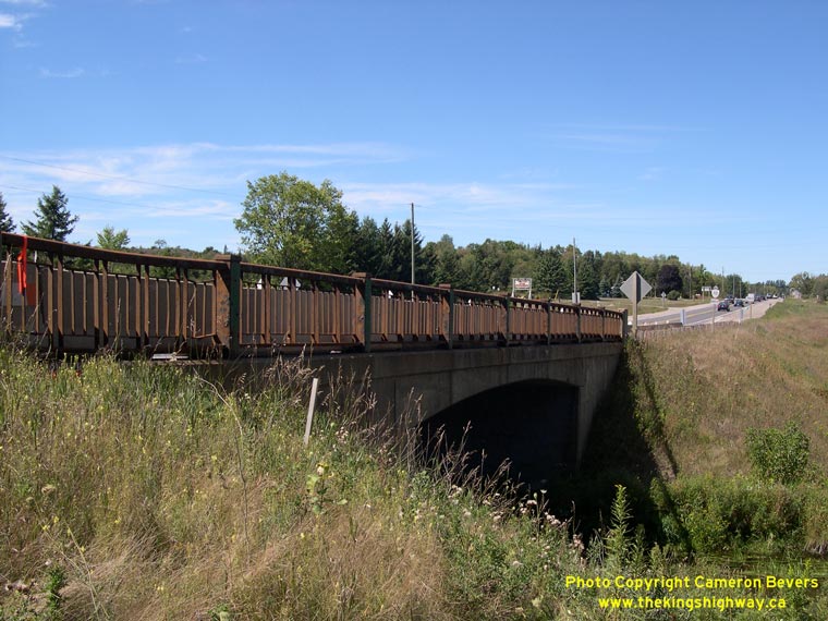
Left - Western side of the Credit River Bridge on Hwy 10 & Hwy 24 north of Caledon Village. This single span concrete rigid frame structure was completed
in 1958. See an Enlarged Photo here. (Photograph taken on September 8, 2007 - © Cameron Bevers) Right - Facing north along Hwy 10 & Hwy 24 at the Credit River Bridge north of Caledon Village. The highway crosses the Credit River again just south of Orangeville. Compare this 2007 photo with this Historic 1967 Photo taken from the same location 40 years earlier. See an Enlarged Photo here. (Photograph taken on September 8, 2007 - © Cameron Bevers) 
Left - Hwy 10 & Hwy 24 facing south towards Caledon Village at the Credit River Bridge. Note the narrow bridge warning signs which were placed on both
sides of the structure. This bridge was widened in 2008-2009 to accommodate the additional traffic lanes built during the highway expansion project. A continuous
illumination system was also installed as a result of the widening in this area. See an
Enlarged Photo here. (Photograph taken on September 8, 2007 - © Cameron Bevers) Right - In 1958, an old concrete structure that had been built by the Department of Public Highways in 1924 was replaced with the new bridge seen here. The old bridge had to be replaced because it was too narrow and was not compatible with the grade revision which took place to the south. See an Enlarged Photo here. (Photograph taken on September 8, 2007 - © Cameron Bevers) 

Left - Facing north along Hwy 10 & Hwy 24 towards Orangeville at the Credit River Bridge north of Caledon Village. Note the single Hwy 10 route marker
at right. Up until 1998, Hwy 10 & Hwy 24 shared a common route between Caledon Village and Shelburne. When the northern section of Hwy 24 was downloaded to the
Counties of Simcoe, Grey and Dufferin in 1998, the former concurrent route of Hwy 10 & Hwy 24 was discontinued. Since 1998, this highway has been signed only as
Hwy 10. See an Enlarged Photo here. (Photograph taken on September 8, 2007 - © Cameron Bevers) Right - Facing south along Hwy 10 & Hwy 24 towards Caledon Village from the Credit River Bridge south of Orangeville, prior to the highway expansion. See an Enlarged Photo here. (Photograph taken on September 8, 2007 - © Cameron Bevers) 

Left - Credit River Bridge on Hwy 10 & Hwy 24 south of Orangeville. This single-span concrete rigid frame structure was completed in 1957. The bridge was
removed and replaced with a brand new structure when the highway was widened from two lanes to a new five-lane cross section in 2009. See an
Enlarged Photo here. (Photograph taken on September 8, 2007 - © Cameron Bevers) Right - Facing south along Hwy 10 & Hwy 24 towards Caledon at the Credit River Bridge south of Orangeville. The highway crosses the Credit River again north of Caledon Village. Only the north bridge was replaced as a result of the recent highway expansion project. The south bridge over the Credit River was widened to match the new highway cross section. See an Enlarged Photo here. (Photograph taken on September 8, 2007 - © Cameron Bevers) 

Left - Eastern side of the Credit River Bridge on Hwy 10 & Hwy 24 south of Orangeville.
See an Enlarged Photo here. (Photograph taken on September 8, 2007 - © Cameron Bevers) Right - Facing north along Hwy 10 & Hwy 24 at the Credit River Bridge south of Orangeville. As a result of the highway widening in 2009, the highway looks substantially different today. A continuous two-way centre left turn lane was constructed in order to service the numerous driveway access points along the highway. See an Enlarged Photo here. (Photograph taken on September 8, 2007 - © Cameron Bevers) 

Left - The Credit River Bridge on Hwy 10 & Hwy 24 south of Orangeville replaced an earlier steel structure that had been built by the Department of Public
Highways in 1924, shortly after Hwy 10 was assumed as a provincial highway. See an
Enlarged Photo here. (Photograph taken on September 8, 2007 - © Cameron Bevers) Right - Approaching Orangeville on Hwy 10 & Hwy 24 prior to widening. This major highway expansion project provided some badly-needed highway capacity and safety improvements along the congested highway corridor between Caledon Village and Orangeville. The contract also marked the completion of a multi-year reconstruction program to widen Hwy 10 to four lanes from the Forks-of-the-Credit Road area northerly to Orangeville. See an Enlarged Photo here. (Photograph taken on September 8, 2007 - © Cameron Bevers) 

Left - Approaching the South Arterial Road on Southbound Hwy 10 & Hwy 24 in Orangeville. This new bypass allows long distance through traffic to access
Dufferin County Road 109 (Formerly Hwy 9) without having to negotiate Orangeville's busy main street (Broadway). Although it is signed as Dufferin County Road 109,
much of the road lies within the Regional Municipality of Peel. See an Enlarged Photo here. (Photograph taken on October 10, 2008 - © Cameron Bevers) Right - Facing west along the South Arterial Road (Riddell Road) from the Hwy 10 Junction in Orangeville. The construction of the Dufferin County Road 109 Bypass created a jurisdictional problem which would have been avoided if Hwy 9 beyond Orangeville was still a provincial highway. The road was built to divert long distance through traffic heading towards Arthur and points to the west away from Downtown Orangeville, but there was insufficient right-of-way to construct this bypass route entirely within the Town of Orangeville's limits. As a result, the bypass route was partially built within the Regional Municipality of Peel, which did not stand to benefit much from the road's construction. This bypass route was situated at the extreme northwestern corner of Peel and was primarily built to resolve a traffic issue in neighbouring Dufferin County. While the South Arterial Road has greatly relieved traffic congestion in Orangeville, the planning and construction of this bypass would have been simplified if it was built and operated as a provincial highway, in my personal opinion. The overall transportation needs of the province would have likely taken precedence over any local municipal issues. See an Enlarged Photo here. (Photograph taken on October 10, 2008 - © Cameron Bevers) 

Left - Approaching the end of Hwy 9 at the Hwy 10 Junction in Orangeville. Prior to the 1990s, Hwy 9 turned right at this junction and briefly joined Hwy 10
& Hwy 24 in a concurrent routing through Orangeville. However, in 1998, a 68 km section of Hwy 9 between Orangeville and Harriston was downloaded to the Counties
of Dufferin and Wellington. The downloaded section of Hwy 9 in the middle is now known as County Road 109. There are no signs at this junction indicating that one
has to follow County Road 109 to access the western leg of Hwy 9 to Kincardine. See an
Enlarged Photo here. (Photograph taken on October 10, 2008 - © Cameron Bevers) Right - Start of the eastern leg of Hwy 9, facing east from the Hwy 10 Junction in Orangeville. See an Enlarged Photo here. (Photograph taken on October 10, 2008 - © Cameron Bevers) 

Left - Green guide sign on Northbound Hwy 10 marking the ramp to Hwy 9 East in Orangeville. See an
Enlarged Photo here. (Photograph taken on October 10, 2008 - © Cameron Bevers) Right - Facing north along the former concurrent route of Hwy 9, Hwy 10, & Hwy 24 in Orangeville. Due to the provincial highway downloading that took place in 1997-1998, this route is now known simply as Hwy 10. The other two routes were downloaded in this area, making the concurrent designation unnecessary for route continuity. See an Enlarged Photo here. (Photograph taken on October 10, 2008 - © Cameron Bevers) 

Left - Approaching the Old Hwy 9 Junction (Broadway) on Hwy 10 & Hwy 24 in Orangeville. Prior to 1998, Hwy 9 departed from Hwy 10 & Hwy 24 at this
intersection, and continued west through Downtown Orangeville towards Harriston and Kincardine. See an
Enlarged Photo here. (Photograph taken on October 10, 2008 - © Cameron Bevers) Right - Old Hwy 9 Junction (Broadway) on Hwy 10 & Hwy 24 in Orangeville. From this vantage point, the former route of Hwy 9 can be seen departing from Hwy 10 & Hwy 24 and heading up the hill into Downtown Orangeville. Until the completion of the Orangeville Bypass in the early 1970s, Hwy 10 & Hwy 24 also followed this route along Broadway through Downtown Orangeville. See an Enlarged Photo here. (Photograph taken on October 10, 2008 - © Cameron Bevers) 

Left - The former concurrent route of Hwy 9, Hwy 10, & Hwy 24 in Orangeville briefly has a seven-lane cross section, with two through lanes in each
direction, dual northbound left-turn lanes and a channelized eastbound right turn ramp. The recent completion of Orangeville's South Arterial Road (Riddell Road) has
greatly relieved congestion at this intersection by allowing through traffic to bypass Orangeville's busy main street, Broadway (Old Hwy 9) entirely. See an
Enlarged Photo here. (Photograph taken on October 10, 2008 - © Cameron Bevers) Right - Facing west along Old Hwy 9 (Broadway) from the Hwy 10 & Hwy 24 Junction in Orangeville. See an Enlarged Photo here. (Photograph taken on October 10, 2008 - © Cameron Bevers) 

Left - Facing north along Hwy 10 & Hwy 24 towards Shelburne from Orangeville. See an
Enlarged Photo here. (Photograph taken on August 2, 2007 - © Cameron Bevers) Right - Former Hwy 10 & Hwy 24 alignment approaching Orangeville. The Orangeville Bypass at left was completed in the 1970s, bypassing this short section of First Street. First Street was then realigned to meet the Orangeville Bypass at a right angle at a new signalized intersection. See an Enlarged Photo here. (Photograph taken on August 2, 2007 - © Cameron Bevers) 

Left - Beginning of Former Hwy 10B & Hwy 24B in Orangeville. The short Hwy 10B & Hwy 24B business route into Downtown Orangeville was decommissioned
many years ago. The former highway route is now just known as First Street. See an
Enlarged Photo here. (Photograph taken on August 2, 2007 - © Cameron Bevers) Right - Facing south along Former Hwy 10B & Hwy 24B (First Street) in Orangeville. See an Enlarged Photo here. (Photograph taken on August 2, 2007 - © Cameron Bevers) 

Left - Facing south along Hwy 10 & Hwy 24 towards Orangeville from Primrose Hill. See an
Enlarged Photo here. (Photograph taken on May 13, 2007 - © Cameron Bevers) Right - Abandoned Hwy 10 & Hwy 24 alignment across Primrose Hill, facing south. The highway was relocated in the 1970s when two passing lanes were added to Hwy 10 & Hwy 24. Although the asphalt was removed long ago, the grade of the original highway is still discernable. See an Enlarged Photo here. (Photograph taken on May 13, 2007 - © Cameron Bevers) 

Left - Abandoned Hwy 10 & Hwy 24 alignment across Primrose Hill, facing north. See an
Enlarged Photo here. (Photograph taken on May 13, 2007 - © Cameron Bevers) Right - The grade of the original highway was much higher than the existing highway. The two large trees on the embankment in the background once lined the original highway. See an Enlarged Photo here. (Photograph taken on May 13, 2007 - © Cameron Bevers) 

Left - Facing south along Hwy 10 & Hwy 24 towards Primrose Hill. See an
Enlarged Photo here. (Photograph taken on May 13, 2007 - © Cameron Bevers) Right - View of Hwy 10, Hwy 24 & Hwy 89 between Shelburne and Primrose, facing east. See an Enlarged Photo here. (Photograph taken on May 13, 2007 - © Cameron Bevers)
Continue on to King's Highway 10 Photos: Shelburne to Flesherton
|
|---|
Links to Adjacent King's Highway Photograph Pages:
Back to King's Highway 9 Photos /
King's Highway 10 History /
On to King's Highway 11 Photos
Ontario Highway History - Main Menu / Back to List of Highways Website contents, photos & text © 2002-2026, Cameron
Bevers (Webmaster) - All Rights Reserved / Contact Me
|
|---|