
| 
| |
|
|
This page contains historical and present day photos of Ontario's King's Highway 112. All photographs displayed on
this page were taken by the Webmaster (Cameron Bevers), unless specifically noted otherwise. Historical photographs are arranged in approximate chronological order,
while present day photographs (Year 2000 to date) are arranged by location from south to north. Click on any thumbnail to see a larger image!
Please note that all photographs displayed on this
website are protected by copyright. These photographs must not be reproduced, published,
electronically stored or copied, distributed, or posted onto other websites without
my written permission. If you want to use photos from this website, please
email me first for permission. Thank-you!
|
|---|
|
Historical King's Highway 112 Photographs
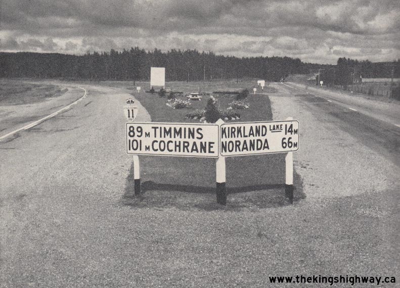
Above - Junction of the Round Lake Cutoff (Hwy 11) and Hwy 112 near Tarzwell in 1952. As originally assumed in 1937, the route of Hwy 11 followed the highway to
the right of this "Y" Junction. In the late 1930s, a program was initiated to reduce the highway distance between North Bay and Cochrane by constructing diversions
along Hwy 11 at key locations. A new highway diversion known as the Round Lake Cutoff was completed from Tarzwell to Kenogami in 1941. The route of Hwy 11 was signed
along this new diversion, as can be seen in this photo at left. Unfortunately, the bypassed section of Hwy 11 at right also retained the Hwy 11 route number.
Motorists arriving at this "Y" Junction from the south were understandably confused, when they saw the route of Hwy 11 forking into two separate highways in front of
them. In what was an apparent acknowledgement of this problem, note that the DHO had already removed the Hwy 11 shield over the Kirkland Lake sign at right even
before this photo was taken in 1952. The problem was ultimately resolved in 1953, when the old north-south section of Hwy 11 leading into Kirkland Lake was given an
entirely new King's Highway route number, thus creating Hwy 112. Photo taken on September 4, 1952. (Photo courtesy of Ontario Ministry of Transportation - © King's Printer for Ontario, 1952) 
Above - View of the "Swastika Wye" at the Hwy 66 & Hwy 112 Junction between Kirkland Lake and Swastika in 1953, facing west. This was one of three
directional "Y" junctions built on the King 's Highways in the Kirkland Lake area - the other two examples were located at nearby Kenogami Lake and Tarzwell. Until
the Wye was rebuilt as a conventional T-intersection in 1956-1957, Hwy 66 forked into two routes approaching this junction. The left fork pointed south towards New Liskeard and North Bay while the right fork led to Timmins and Cochrane. At the time this photo was taken in 1953, Hwy 66 reached its official western
terminus at this highway junction. Although unsigned at the junction, the "north-south" highway route through the Swastika Wye was considered to be a part of Hwy 11
and was illustrated as such on Official Road Maps up until 1953. Historically, the highway route
numbering in the Kirkland Lake area was very confusing, as there were two different routes for Hwy 11 between Tarzwell and Kenogami Lake. The "through" route of
Hwy 11 followed the Round Lake Diversion between Tarzwell and Kenogami Lake, which was a newer cut-off highway constructed during the opening years of World War II.
Conversely, the original 1937 route of Hwy 11 went up to Kenogami Lake via Dane and Swastika. The confusing route numbering situation was resolved late in 1953, when
the highway between Tarzwell and the Swastika Wye was renumbered as Hwy 112, while the highway between the Swastika Wye and the Kenogami Wye was renumbered as a
westerly extension of Hwy 66. Note the cemetery chapel on the far side of the Wye, which still stands beside the Hwy 66 & Hwy 112 Junction today. Photo
taken on August 12, 1953. (Photo courtesy of Ontario Ministry of Transportation - © King's Printer for Ontario, 1953) |
|---|
|
Present Day King's Highway 112 Photographs

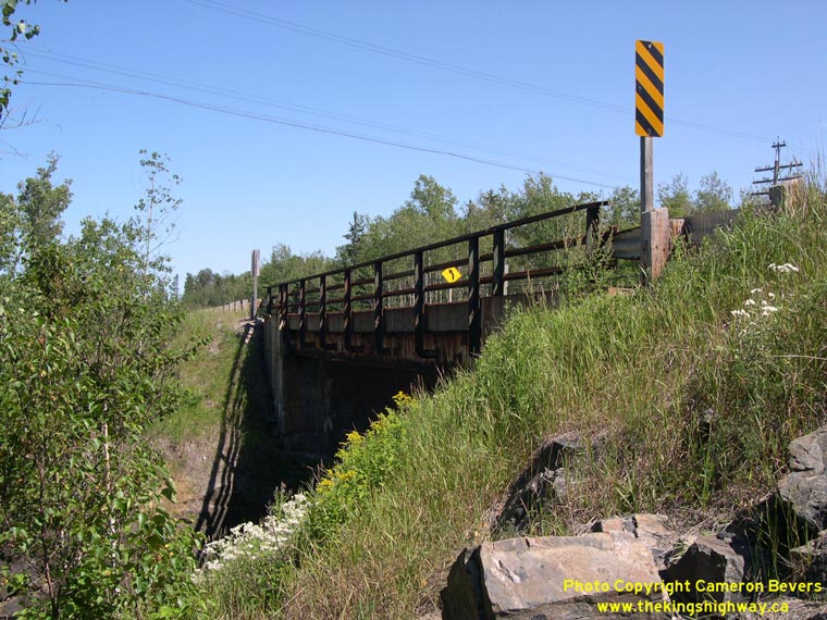
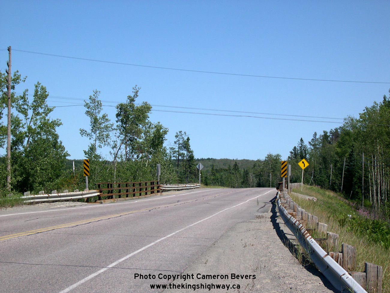
Left - Facing north along Hwy 112 at the Ontario Northland Railway (ONR) Overhead near Tarzwell. See an
Enlarged Photo Here. (Photograph taken on August 18, 2003 - © Cameron Bevers) Right - ONR Overhead on Hwy 112 near Tarzwell. Structure completed in 1937. See an Enlarged Photo Here. (Photograph taken on August 18, 2003 - © Cameron Bevers) 

Left - Junction of Hwy 66 & Hwy 112 near Swastika, facing east towards Kirkland Lake. At this junction, traffic can either continue straight ahead (east)
on Hwy 66 towards Kirkland Lake, or turn right and head south via Hwy 112 towards the Hwy 11 Junction at Tarzwell. The vintage 1950s-era highway luminaires at the
junction were replaced during a recent highway reconstruction project. See an Enlarged Photo Here. (Photograph taken on September 2, 2007 - © Cameron Bevers) Right - Green guide signs on northbound Hwy 112 approaching the Hwy 66 Junction between Swastika and Kirkland Lake. See an Enlarged Photo Here. (Photograph taken on September 2, 2007 - © Cameron Bevers) 

Left - An abandoned Hwy 66 alignment located immediately east of the Hwy 112 Junction. Up until the 1950s, Hwy 112 and Hwy 66 met at a directional "Y" junction,
known locally as the "Swastika Wye". Most of the western leg of the Swastika Wye was removed during construction of the current highway junction in 1956-1957, but the
eastern leg of the junction pointing towards Kirkland Lake was mostly left intact and was simply abandoned in the forest, as seen here. See an
Enlarged Photo Here. (Photograph taken on September 2, 2007 - © Cameron Bevers) Right - Junction sign assembly at the northern terminus of Hwy 112 at the Hwy 66 Junction between Swastika and Kirkland Lake. See an Enlarged Photo Here. (Photograph taken on September 2, 2007 - © Cameron Bevers) 

Left - This abandoned Hwy 112 alignment once formed the southern approach to the old Swastika Wye. The old highway lies hidden in the forest today, next to the
current Hwy 66 & Hwy 112 Junction. Up until reconstruction in 1956-1957, the two legs of the Wye flared apart here and went their separate ways. The western leg
pointed towards westbound Hwy 66 to Swastika, while the eastern leg pointed towards eastbound Hwy 66 to Kirkland Lake. The western leg of the Swastika Wye was
obliterated during construction of the new highway junction in the 1950s. Only a curved retaining wall in front of an adjacent cemetery provides a hint of the old
Wye's configuration. See an Enlarged Photo Here. (Photograph taken on September 2, 2007 - © Cameron Bevers) Right - Facing north along Hwy 112 approaching the present-day Hwy 66 Junction between Swastika and Kirkland Lake. When this new intersection was completed in 1957, it supplanted the old Swastika Wye. At right, a channelized right-turn ramp carries traffic bound for Kirkland Lake from northbound Hwy 112 onto eastbound Hwy 66. See an Enlarged Photo Here. (Photograph taken on September 2, 2007 - © Cameron Bevers) 

Left - Green guide signs at the Hwy 112 & Hwy 66 Junction between Swastika and Kirkland Lake. See an
Enlarged Photo Here. (Photograph taken on September 2, 2007 - © Cameron Bevers) Right - Facing west along Hwy 66 towards Swastika at the Hwy 112 Junction west of Kirkland Lake. This new highway junction was completed in 1957, as part of a general reconstruction of Hwy 66 between Kirkland Lake and Hwy 11 at Kenogami Lake. This new highway junction replaced the former Swastika Wye, which had poor sight lines for traffic stopped at the various intersections within the Wye. Following reconstruction in the 1950s, Hwy 112 met Hwy 66 at more or less a right angle which ensured much safer intersection operations. Compare this present-day photo of the Hwy 66 & Hwy 112 Junction to this Historical 1953 Photo of the old Swastika Wye. See an Enlarged Photo Here. (Photograph taken on September 2, 2007 - © Cameron Bevers)
More King's Highway 112 Photographs Coming Soon!
|
|---|
Links to Adjacent King's Highway Photograph Pages:
Back to King's Highway 111 Photos /
King's Highway 112 History /
On to King's Highway 114 Photos
Ontario Highway History - Main Menu / Back to List of Highways Website contents, photos & text © 2002-2026, Cameron
Bevers (Webmaster) - All Rights Reserved / Contact Me
|
|---|