
| 
| |
|
|
This page contains historical photos of Ontario's King's Highway 17 dating from 1920 to 1939. All photographs displayed on
this page were taken by the Ontario Ministry of Transportation, unless specifically noted otherwise. Historical photographs are arranged in approximate chronological
order. Click on any thumbnail to see a larger image!
Please note that all photographs displayed on this
website are protected by copyright. These photographs must not be reproduced, published,
electronically stored or copied, distributed, or posted onto other websites without
my written permission. If you want to use photos from this website, please
email me first for permission. Thank-you!
|
|---|
|
Page 1: Historical King's Highway 17 Photographs (1920 to 1939)

Above - Historical stone monument at the start of the Ottawa-Point Fortune Provincial Highway (Hwy 17). This monument marked the boundary line between Upper
Canada and Lower Canada, which later became the Province of Ontario and the Province of Quebec. See an
Enlarged Photo Here. Photo taken in 1922. (Photo courtesy of Ontario Ministry of Transportation - © King's Printer for Ontario, 1922) 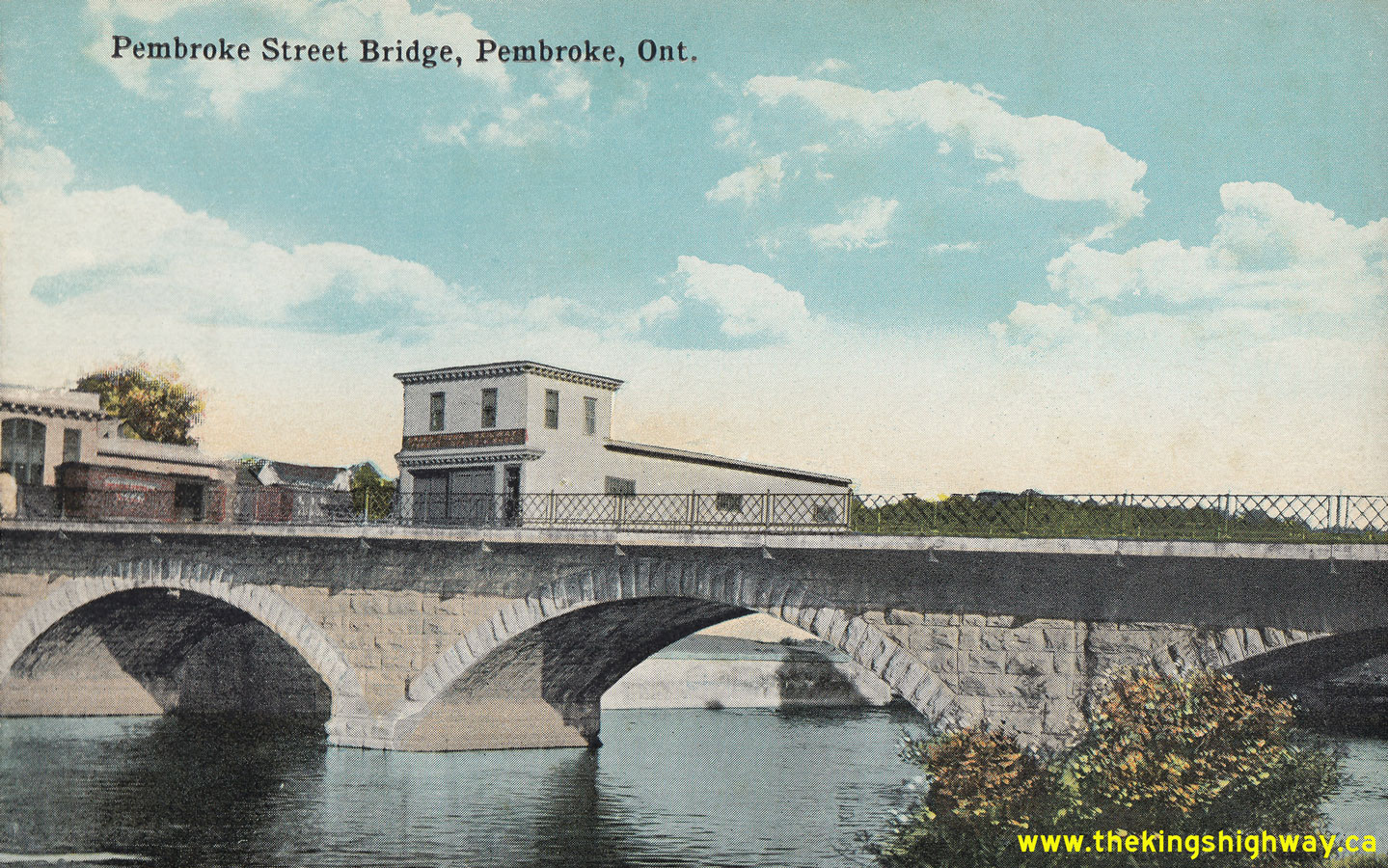
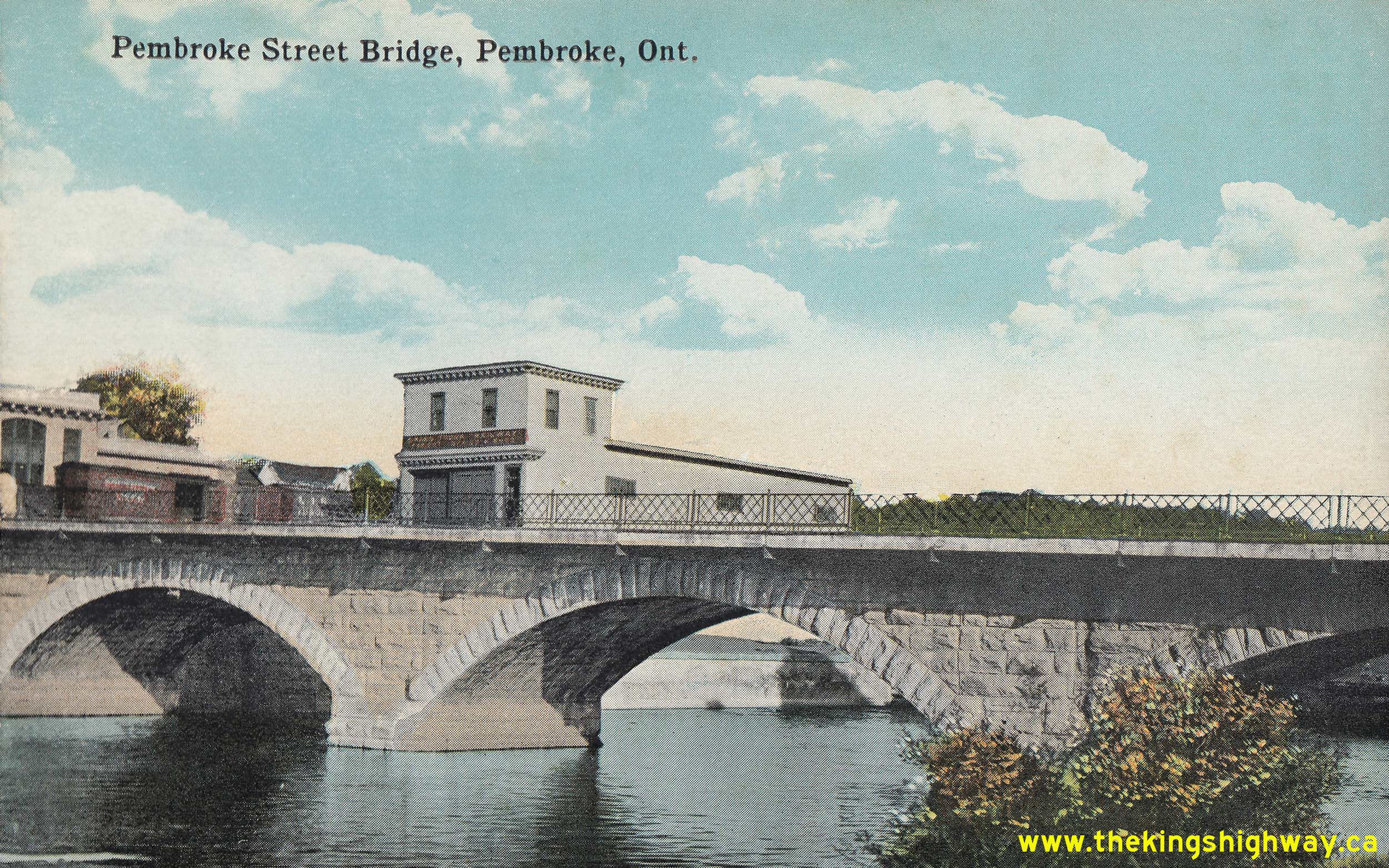
Above - Circa 1925 postcard view of the Muskrat River Bridge on Pembroke Street (Hwy 17, later known as Hwy 148) in Downtown Pembroke. This attractive
Victorian-era stone arch bridge was constructed in 1887. The bridge was widened by the Department of Highways of Ontario (DHO) in 1939. This postcard view shows the
Muskrat River Bridge's original 19th-Century appearance, as it existed prior to the DHO's widening of Hwy 17 during the 1930s. See an
Enlarged Photo Here. Photo taken circa 1925. (Photo from Cameron Bevers' historical photograph collection - Original photographer unknown) 

Left - New two-span concrete bowstring arch bridge across the South Nation River on Hwy 17 in Plantagenet, Contract #1926-160. This structure was completed
and opened to traffic in 1927. It replaced a narrow steel through truss bridge located a short distance upstream. At the time of construction in 1926-1927, these
concrete truss spans were the longest ever built by the Department of Public Highways, with a span length of approximately 119 feet each. See an
Enlarged Photo Here. Photo taken in 1927. (Photo courtesy of Ontario Ministry of Transportation - © King's Printer for Ontario, 1927) Right - Mixed macadam pavement on Hwy 17 east of Hawkesbury, Contract #1928-16. See an Enlarged Photo Here. Photo taken in 1930. (Photo courtesy of Ontario Ministry of Transportation - © King's Printer for Ontario, 1930) 
Left - New concrete pavement on Hwy 17 east of Arnprior, Contract #1929-44. See an
Enlarged Photo Here. Photo taken in 1930. (Photo courtesy of Ontario Ministry of Transportation - © King's Printer for Ontario, 1930) Right - Circa 1930 postcard view of the original steel through truss bridge across the West Branch of the Winnipeg River on Hwy 17 between Kenora and Keewatin. A new steel deck arch bridge was built at this location in 1949, which replaced this narrow through truss structure. See an Enlarged Photo Here. (Photo from Cameron Bevers' historical photograph collection - Original photographer unknown) 

Left - View of the new Madawaska River Bridge on Hwy 17 in Arnprior, which was completed in 1928. This impressive 10-span concrete bridge had a length of
530 feet. This structure remained in service until the mid-1970s, when it was replaced by the current Madawaska River Bridge. See an
Enlarged Photo Here. Photo taken in 1930. (Photo courtesy of Ontario Ministry of Transportation - © King's Printer for Ontario, 1930) Right - Circa 1930 view of Hwy 17 just west of Arnprior. This photo shows the bituminous penetration pavement laid along 2 1/2 miles of Hwy 17 from Arnprior westerly in 1925, under Contract #1195. This was one of many paving contracts called between 1925 and 1935 to construct a paved surface along Hwy 17 between Ottawa and Pembroke. The final 10-mile gap in the pavement along Hwy 17 through the Lower Ottawa Valley was completed east of Renfrew in 1936. Note the slight curve in the highway to the right in the background. Although it may seem hard to believe, this photo was taken at the location of the present-day McDonald's Restaurant on Daniel Street (Old Hwy 17) in Arnprior. See an Enlarged Photo Here. Photo taken circa 1930. (Photo © Archives of Ontario - Series RG-14-162-2-27, Box B984, Photo #16) 
Above - Engineering and construction staff on the newly-opened Trans-Canada Highway (Hwy 17) at the Ontario-Manitoba Boundary in 1932. The new highway link
between Kenora and the Manitoba Boundary was constructed by Ontario's Department of Northern Development and was officially opened to traffic on July 1, 1932. This
section of the Trans-Canada Highway was designated as a part of King's Highway 17 in 1937, when the Department of Northern Development was amalgamated with the
Department of Highways of Ontario (DHO). Although the timber welcome arch seen in this photo was removed by the end of the 1930s, there has been a sign which has
welcomed motorists to Ontario ever since the Trans-Canada Highway first opened to traffic. See an
Enlarged Photo Here. Photo taken in 1932. (Photo © Archives of Ontario - Series RG-14-162-2-108, Box B984, Photo #85) 
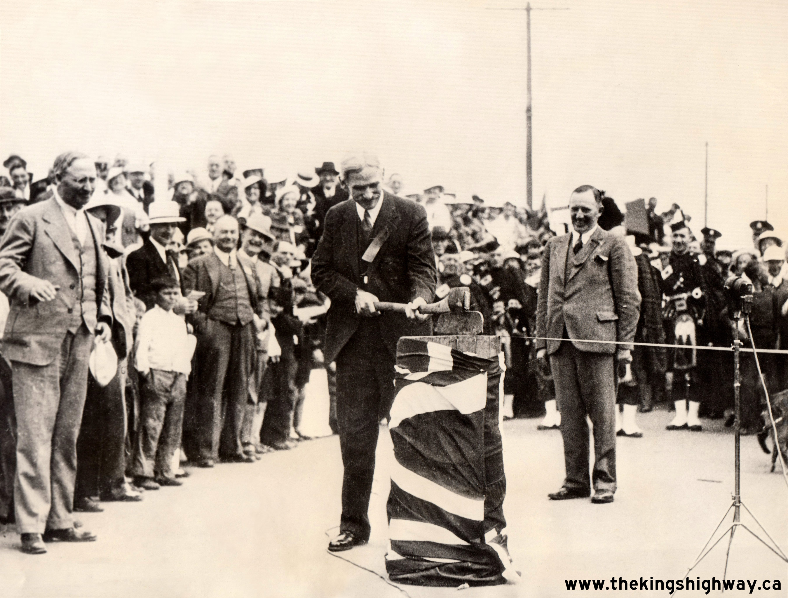
Above - Ontario Minister of Northern Development, Lands and Forests Peter Heenan officially opens the Trans-Canada Highway (Hwy 17) to traffic between Kenora
and the lakehead cities of Fort William and Port Arthur in 1935. This opening ceremony took place a short distance west of Fort William. See an
Enlarged Photo Here.
Photo taken on July 1, 1935. (Photo courtesy of ACME Newspictures) 
Above - North Shore Highway (Hwy 17) at Cavers Hill, looking southwest towards Lake Superior in 1935. This photo shows the newly-built pass on the North Shore
Highway across Cavers Hill. The rugged ridge forming Cavers Hill juts several kilometres out into Lake Superior, where the land drops precipitously into the lake. The
ridge proved to be one of the greatest obstacles in building the North Shore Highway in the 1930s. The route chosen for the highway ran up a steep sided ravine. The
highway climbed to a summit 800 feet above the lake in less than 3 km. The steep grade proved troublesome for many vehicles, so the highway was completely relocated
onto a revised grade in the early 1960s. The old Cavers Hill alignment seen here now sits abandoned and overgrown in a forest a short distance away from the
present-day route of Hwy 17. See an Enlarged Photo Here. Photo taken in September 1935. (Photo © Archives of Ontario - Series RG-14-162-2-27, Box B984) 
Above - Circa 1935 postcard view of the Sudbury-Sault Ste. Marie Trunk Road (Hwy 17) near Espanola. See an
Enlarged Photo Here. (Photo courtesy of N. Cummings, Massey) 

Left - Early motorists on the newly-built Trans-Canada Highway (Hwy 17) taking a break at Richard Lake east of Kenora. See an
Enlarged Photo Here. Photo taken circa 1935. (Photo from Cameron Bevers' historical photograph collection - Original photographer unknown) Right - Circa 1935 view of a Depression-era work crew building the North Shore Highway (Hwy 17) by hand between Nipigon and Kama Hill. Many roads were built in Northern Ontario during the Great Depression as unemployment relief projects, after people found themselves out-of-work in large numbers due to the sharp economic downturn. Manual labour was used wherever possible on road projects to maximize unemployment relief for remote communities which were paralysed by the effects of the Great Depression. Labourers toiled for years building the North Shore Highway, before it was eventually linked to the Trans-Canada Highway and assumed as part of Hwy 17 in 1937. The North Shore Highway passes through some of the most rugged and remote terrain in Ontario, so the fact that this highway was built almost entirely with manual labour makes its construction particularly remarkable! See an Enlarged Photo Here. Photo taken circa 1935. (Photo from Cameron Bevers' historical photograph collection - Original photographer unknown) 
Above - Concrete pavement on a new Hwy 17 Diversion at the Alfred-Plantagenet Township Boundary east of Ottawa. See an
Enlarged Photo Here. Photo taken in 1936. (Photo courtesy of Ontario Ministry of Transportation - © King's Printer for Ontario, 1936) 

Left - Circa 1937 postcard view of the North Shore Highway (Hwy 17) near Kama Hill, facing west towards Nipigon. The North Shore Highway was constructed
between Schreiber and the Nipigon River at Lake Helen in the mid-1930s. Initially, this road was not contiguous to the rest of Northwestern Ontario's road system.
Construction began on a new bridge across the Nipigon River in 1936, which eventually linked the North Shore Highway with the Nipigon to Port Arthur section of the
Trans-Canada Highway. Both the North Shore Highway and Trans-Canada Highway were assumed by the Department of Highways of Ontario (DHO) as part of Hwy 17 in 1937.
See an Enlarged Photo Here. Photo taken circa 1937. (Photo courtesy of The Camera Shop, Port Arthur) Right - Official opening ceremony at the Nipigon River Bridge on Hwy 17 in 1937. The completion of the Nipigon River Bridge was one of the most widely anticipated highway construction projects in Northwestern Ontario's history. The new bridge united the North Shore Highway between Lake Helen and Schreiber with the rest of the Trans-Canada Highway (Hwy 17) which ran from Nipigon westerly to Port Arthur. Prior to the completion of the Nipigon River Bridge, automobiles had to be transported by rail or by boat between the two discontinuous highways. The Nipigon River Bridge was built under Contract #1936-108. See an Enlarged Photo Here. Photo taken on September 24, 1937. (Photo courtesy of The Camera Shop, Port Arthur) 

Left - Pass across Cavers Hill in 1937, showing the new stone retaining wall at right. Despite the deep ravine beside the highway, there were no roadside
barriers up Cavers Hill for the first few years of operation. The stone walls beside the highway were installed in 1937, once the North Shore Highway was assumed as
part of Hwy 17. See an Enlarged Photo Here. Photo taken in 1937. (Photo courtesy of Ontario Ministry of Transportation - © King's Printer for Ontario, 1937) Right - Nipigon River Bridge on Hwy 17, shortly after opening in September 1937. See an Enlarged Photo Here. Photo taken in 1937. (Photo courtesy of Ontario Ministry of Transportation - © King's Printer for Ontario, 1937) 
Above - The new Keewatin Channel Bridge on Hwy 17 west of Kenora, shown shortly after completion in 1938. At a total length of almost 850 feet, this structure
is the longest bridge on Hwy 17. It is also one of Northern Ontario's most beautiful bridges. The bridge was originally constructed under Contract #1937-270 and was
rehabilitated in 1999. Thankfully, all of the ornamental features of the bridge, including the embossed concrete balusters and stylish steel and concrete deck arches
were restored to their original 1930s appearance. See an Enlarged Photo Here. Photo taken in
1938. (Photo courtesy of Ontario Ministry of Transportation - © King's Printer for Ontario, 1938) 
Above - View of the Ottawa River from the Deux Rivieres Lookout on Hwy 17, located 23 miles east of Mattawa. See an
Enlarged Photo Here. Photo taken in 1939. (Photo courtesy of Ontario Ministry of Transportation - © King's Printer for Ontario, 1939) 

Left - Facing west along Hwy 17 towards Nipigon from Kama Hill. See an
Enlarged Photo Here. Photo taken on August 26, 1939. (Photo courtesy of Ontario Ministry of Transportation - © King's Printer for Ontario, 1939) Right - New asphalt pavement and zone striping on Hwy 17 near Kenora, 12 miles east of the Ontario-Manitoba Boundary. See an Enlarged Photo Here. Photo taken on September 1, 1939. (Photo courtesy of Ontario Ministry of Transportation - © King's Printer for Ontario, 1939) 
Above - Western terminus of Hwy 17 at the Ontario-Manitoba Boundary, facing east towards Kenora. Note the distance assurance sign at right, showing the
distance to Fort William, Toronto and Montreal. It is interesting to note that the distance to London, England is also shown on this sign - a rather symbolic and
patriotic gesture, given that this was (and still is) the western entrance to Ontario's King's Highway system. See an
Enlarged Photo Here. Photo taken on September 1, 1939. (Photo courtesy of Ontario Ministry of Transportation - © King's Printer for Ontario, 2017) 

Left - Facing west along Hwy 17 towards the Cameron Bay Bridge and Lake of the Woods near Kenora in 1939. The original Cameron Bay Bridge was a timber through
truss bridge, similar in design to the famous Sioux Narrows Bridge on Hwy 71. This structure consists of two timber through truss (Howe type) spans and three approach
spans. The bridge was built under Contract #1937-125 and was completed in 1938. Sadly, this magnificent bridge was demolished in 1971, following the completion of a
modern concrete and steel bridge. Compare this Historic 1939 Photo to this 2003 Photo which I
took of the east approach to the current Cameron Bay Bridge. See an Enlarged Photo Here. Photo
taken on September 1, 1939. (Photo © Archives of Ontario - Series RG-14-162-2-27, Box B984, Photo #2552S) Right - Curve on Hwy 17 at Dogtooth Lake, 20 miles east of Kenora in 1939. This photo shows the original gravel highway only a few years after this section of Hwy 17 was first constructed. Note the stack of cedar delineator posts on the right-hand side of the road, waiting to be installed. On the left-hand side of the road is an early distance assurance sign mounted on a pole, indicating that it is 70 miles to Dryden from this point. See an Enlarged Photo Here. Photo taken on September 4, 1939. (Photo © Archives of Ontario - Series RG-14-162-2-27, Box B984, Photo #2623S) 
Above - Postcard view of Hwy 17 at the Port Arthur Welcome Arch in 1939. Welcome arches such as this were a common sight at the entrances to many Northern
Ontario towns up until the 1960s and 1970s. Nearly all of these welcome arches were built during the 1930s and many of them feature some type of Art Deco-inspired
embellishment. Of all the welcome arches that existed in Ontario, the Port Arthur Welcome Arch was the finest example built during the Art Deco period. The arch was
blue in colour, and boasted bright neon tube letters and an internally illuminated electric clock above the highway. See an
Enlarged Photo Here. Photo taken in 1939. (Photo courtesy of The Camera Shop, Port Arthur)
Continue on to King's Highway 17 Photos: Historical Photos: 1940-1949
|
|---|
Links to Adjacent King's Highway Photograph Pages:
Back to King's Highway 16 Photos /
King's Highway 17 History /
On to King's Highway 18 Photos
Ontario Highway History - Main Menu / Back to List of Highways Website contents, photos & text © 2002-2026, Cameron
Bevers (Webmaster) - All Rights Reserved / Contact Me
|
|---|