
| 
| |
|
|
This page contains historical photos of Ontario's King's Highway 26 dating from 1927 to 1999. All photographs displayed on
this page were taken by the Ontario Ministry of Transportation, unless specifically noted otherwise. Historical photographs are arranged in approximate chronological
order. Click on any thumbnail to see a larger image!
Please note that all photographs displayed on this
website are protected by copyright. These photographs must not be reproduced, published,
electronically stored or copied, distributed, or posted onto other websites without
my written permission. If you want to use photos from this website, please
email me first for permission. Thank-you!
|
|---|
|
Page 1: Historical King's Highway 26 Photographs (1927-1999)

Above - New Nottawasaga River Bridge on Hwy 26 at Edenvale, shortly after completion (1931) (Photo courtesy of Ontario Ministry of Transportation - © King's Printer for Ontario, 1931) 

Left - Single-lane concrete pavement on Hwy 26 east of Stayner in 1933. In the lean economic times of the 1930s, the Department of Highways of Ontario (DHO)
would often construct only a single 10-foot strip of concrete pavement, rather than pave the full width of the highway. While this method of providing a "paved
highway" was economical and simplified construction staging, the resulting road surface was not popular with the motoring public. Drivers would often deliberately
drive on the wrong side of the road, to avoid the unpaved highway lane with a gravel or dirt surface. Accordingly, motorists driving on the paved lane always had to
be on the lookout for traffic heading in the opposite direction in their lane. These single-lane pavements became surprisingly common on less-traveled King's Highways
by the late 1930s. These narrow concrete ribbons were soon dubbed "Hepburn Sidewalks" by frustrated motorists of the day. The rather dishonourable nickname was
derived from the name of Ontario Prime Minister (Premier) Mitchell Hepburn, whose government was responsible for building many miles of these single-lane concrete
highways across rural Ontario in the 1930s and early 1940s. Historians will note, however, that the practice of paving single-lane highways (including the Hwy 26
example illustrated above) actually began during the tenure of George S. Henry, Mitchell Hepburn's predecessor. After George S. Henry's government was defeated in the
1934 Ontario Provincial Election, Mitchell Hepburn's government merely continued this scant highway improvement practice. Photo taken in 1933. (Photo courtesy of Ontario Ministry of Transportation - © King's Printer for Ontario, 1933) Right - New macadam pavement and zone striping on Hwy 26, showing a permissive passing area west of Craigleith (1934) (Photo courtesy of Ontario Ministry of Transportation - © King's Printer for Ontario, 1934) 
Above - Circa 1937 postcard view of Hwy 26 at the Bighead River Bridge in Downtown Meaford, facing west. Note the curbside Esso gasoline pumps at left. In the
1930s, there were few regulations regarding the placement of gasoline pumps in such close proximity to the edge of a King's Highway. This approach to gasoline
retailing was sensibly changed as the years went by, due to the obvious safety hazard created by curbside gasoline pumps such as this. See an
Enlarged Photo Here. (Photo courtesy of the Photogelatine Engraving Company Ltd, Ottawa) 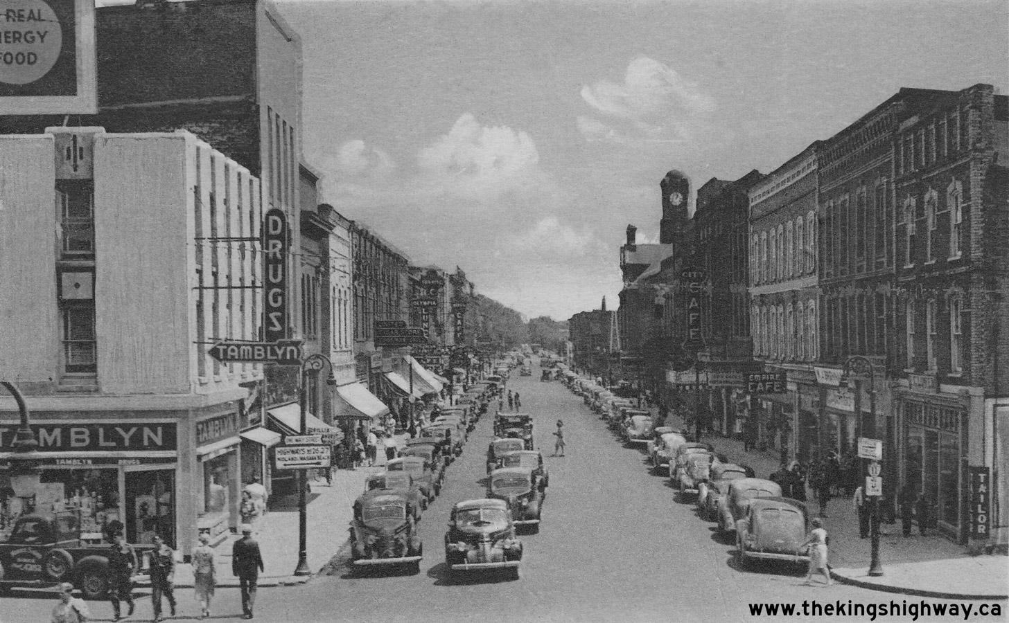
Above - Circa 1940 postcard view of Hwy 11 (Dunlop Street) in Downtown Barrie, facing east from the Hwy 26 & Hwy 27 Junction. See an
Enlarged Photo Here. (Photo courtesy of the Photogelatine Engraving Company Ltd, Ottawa) 
Left - Sign marking the Department of Highways' Roadside Park at Craigleith between Collingwood and Meaford. See an
Enlarged Photo Here. Photo taken on August 25, 1949. (Photo courtesy of Ontario Ministry of Transportation - © King's Printer for Ontario, 1949) Right - View of Hwy 26, four miles east of Owen Sound. See an Enlarged Photo Here. Photo taken on July 20, 1951. (Photo courtesy of Ontario Ministry of Transportation - © King's Printer for Ontario, 1955) 

Left - Department of Highways' Craigleith Park on Hwy 26 between Collingwood and Meaford in 1951. This roadside park beside Georgian Bay was later turned over to
the Department of Lands and Forests and was designated as Craigleith Provincial Park. Many of Ontario's current provincial parks actually began as roadside parks and
campgrounds developed and operated by the Department of Highways for the convenience of motorists. Photo taken on July 20, 1951. (Photo courtesy of Ontario Ministry of Transportation - © King's Printer for Ontario, 1951) Right - Department of Highways' Owen Sound District Garage and Paint Shop. Photo taken on October 29, 1952. (Photo courtesy of Ontario Ministry of Transportation - © King's Printer for Ontario, 1952) 

Left - Highway sign storage room at the Owen Sound District Garage in 1952. Note the "Junction" sign for Hwy 6 & Hwy 21 leaning against the wall. Despite
the widespread downloading of Ontario's King's Highways in the 1990s, the overlapped route of Hwy 6 & Hwy 21 still remains intact today between Springmount and
Owen Sound. Photo taken on October 29, 1952. (Photo courtesy of Ontario Ministry of Transportation - © King's Printer for Ontario, 1952) Right - Aerial view of the Hwy 26 & Hwy 27 (Bayfield Street) Interchange on Hwy 400 in Barrie, facing south. Photo taken on July 9, 1954. (Photo courtesy of Ontario Ministry of Transportation - © King's Printer for Ontario, 1954) 
Above - Looking north along Hwy 400 approaching the Hwy 26 & Hwy 27 (Bayfield Street) Interchange in Barrie. Photo taken on November 5, 1953. (Photo courtesy of Ontario Ministry of Transportation - © King's Printer for Ontario, 1953) 
Above - Progress on a grading and culvert contract on Hwy 26, 6 1/2 miles east of Owen Sound. Photo taken on August 29, 1956. (Photo courtesy of Ontario Ministry of Transportation - © King's Printer for Ontario, 1956) 
Above - Resurfaced section of Hwy 26, one mile west of Midhurst. Photo taken on November 7, 1956. (Photo courtesy of Ontario Ministry of Transportation - © King's Printer for Ontario, 1956) 

Left - Facing east along Hwy 26 at Woodford, showing completed grading work on a new diversion before paving. Photo taken on August 29, 1956. (Photo courtesy of Ontario Ministry of Transportation - © King's Printer for Ontario, 1956) Right - Hot mix asphalt surface on the Woodford Diversion on Hwy 26 east of Owen Sound (1957) (Photo courtesy of Ontario Ministry of Transportation - © King's Printer for Ontario, 1957) 
Above - Facing east along Hwy 26 between Meaford and Craigleith (1958) (Photo courtesy of Ontario Ministry of Transportation - © King's Printer for Ontario, 1958) 
Above - Clearing snow along Hwy 26 just east of Stayner using the "Sno-Go" plow in 1958. See an
Enlarged Photo Here. Photo taken on February 20, 1958. (Photo courtesy of Ontario Ministry of Transportation - © King's Printer for Ontario, 1958) 

Left - Postcard view of Hurontario Street (Hwy 26) approaching First Street in Downtown Collingwood in 1960. Today, Collingwood is an all-season recreational
centre. It is particularly busy in the winter months when the area's famous ski resorts are doing brisk business. However, recreational tourism was not always
Collingwood's main industry - its historical industry was actually ship-building. In this photo, the new ship "Carol Lake" can be seen nearing completion in
Collingwood's shipyards in the background. The shipyards have long since closed and the industrial harbour area has recently been redeveloped into condos and upscale
commercial areas. The Loblaws grocery store in this photo at left was subsequently expanded. The Loblaws ultimately displaced the Pontiac car dealership and Esso gas
station at the intersection. Interestingly, the grocery store still operates at this location today under the Loblaws brand name. In 1971, Hwy 26 was rerouted through
Collingwood via Huron Street and Pretty River Parkway. Hurontario Street subsequently became a part of Hwy 24. See an
Enlarged Photo Here. Photo taken in 1960. (Photo courtesy of Saunders, Collingwood) Right - Circa 1960 postcard view of Dunlop Street (Hwy 11) facing east from the Hwy 26 & Hwy 27 Junction in Downtown Barrie. This interesting photo shows the "five points" intersection in the City Centre, with the traffic signals operating in an "All Red" phase to allow exclusive pedestrian movements. The completion of the Barrie Bypass (Hwy 400) during the Summer of 1952 relieved Downtown Barrie of the burdensome long-distance through traffic which once clogged the city centre. Two of the province's major north-south highways (Hwy 11 and Hwy 27) converged into a single overlapped route through Barrie. See an Enlarged Photo Here. (Photo courtesy of Norman Sanderson) 

Left - Facing south along Bayfield Street (Hwy 26 & Hwy 27) at the Hwy 400 Interchange in Barrie. See an
Enlarged Photo Here. Photo taken on May 30, 1962. (Photo courtesy of Ontario Ministry of Transportation - © King's Printer for Ontario, 2019) Right - Bayfield Street (Hwy 26 & Hwy 27) Overpass at the Hwy 400 Interchange in Barrie. See an Enlarged Photo Here. Photo taken on May 30, 1962. (Photo courtesy of Ontario Ministry of Transportation - © King's Printer for Ontario, 2019) 
Above - Resurfacing a section of Hwy 26 (Hume Street) in Collingwood (1964) (Photo courtesy of Ontario Ministry of Transportation - © King's Printer for Ontario, 1964) 
Above - Northern side of the Marl Creek Bridge on Hwy 26 between Minesing and Horseshoe Valley Road. See an
Enlarged Photo Here. Photo taken on July 6, 1965. (Photo courtesy of Ontario Ministry of Transportation - © King's Printer for Ontario, 2016) 

Left - A wrecking ball prepares to demolish an old concrete culvert on Hwy 26 near Owen Sound (1970) (Photo courtesy of Ontario Ministry of Transportation - © King's Printer for Ontario, 1970) Right - Gradall machine constructing a new roadside drainage ditch along Hwy 26 west of Collingwood (1971) (Photo courtesy of Ontario Ministry of Transportation - © King's Printer for Ontario, 1971) 

Left - Facing west along Hwy 26 at the new Batteaux River Bridge east of Collingwood. See an
Enlarged Photo Here. Photo taken on September 24, 1971. (Photo courtesy of Ontario Ministry of Transportation - © King's Printer for Ontario, 2016) Right - New Batteaux River Bridge on Hwy 26 east of Collingwood. This single span concrete rigid frame structure was completed in 1970. See an Enlarged Photo Here. Photo taken on September 24, 1971. (Photo courtesy of Ontario Ministry of Transportation - © King's Printer for Ontario, 2016) 
Above - Aerial view of the Hwy 400 and Bayfield Street (Hwy 26 & Hwy 27) Interchange in Barrie in 1974. This aerial photo shows the original
interchange ramp configuration, with the loop ramp from Hwy 400 North to Hwy 26 & Hwy 27 in the northeast interchange quadrant. This loop ramp was
closed to traffic shortly after this photo was taken. In 1981, the diamond ramp in the northwest quadrant was realigned to permit the construction of a new
loop ramp from northbound Bayfield Street to Hwy 400 South. The construction of this new loop ramp eliminated left turns at the ramp to Hwy 400 South. This
allowed for the removal of the problematic traffic signals at the original west ramp terminal, which were situated only 80 metres from the traffic signals
at the east ramp terminal. (Photo courtesy of Ontario Ministry of Transportation - © King's Printer for Ontario, 2010) 
Above - Facing north along Hwy 400 approaching the Hwy 26 & Hwy 27 Interchange in Barrie in 1975. The overpass in the foreground is Sunnidale
Road. Note the pre-Metric sign for Hwy 26 & Hwy 27 at right, showing the distance to the exit in miles. Ontario's highway signs were converted to
Metric measurements in 1977. Photo taken on October 8, 1975. (Photo courtesy of Ontario Ministry of Transportation - © King's Printer for Ontario, 2011) 

Left - Facing north along Bayfield Street (Hwy 26 & Hwy 27) from the Hwy 400 Interchange in Barrie. Photo taken on August 3, 1978. (Photo courtesy of Ontario Ministry of Transportation - © King's Printer for Ontario, 2010) Right - Bayfield Street (Hwy 26 & Hwy 27) Overpass on Hwy 400 in Barrie facing north. When the Bayfield Street Interchange was first built in the early 1950s, there was a loop ramp on the north side of the Bayfield Street structure which carried traffic bound for Hwy 26 West and Hwy 27 North. During the mid-1970s, this loop ramp was closed off and abandoned. Note the old overhead bridge-mounted sign support structure which used to have a sign attached to it directing northbound traffic onto this loop ramp. Photo taken on August 3, 1978. (Photo courtesy of Ontario Ministry of Transportation - © King's Printer for Ontario, 2010) 

Left - Northern side of the Bayfield Street (Hwy 26 & Hwy 27) Overpass on Hwy 400 in Barrie in 1979, shortly before the interchange was
reconstructed. In 1981, the Bayfield Street Overpass was widened and the ramps in the northwest interchange quadrant were reconfigured. The off ramp from Hwy 400 South to Bayfield Street was relocated further to
the north and a new loop ramp was constructed for traffic on Bayfield Street North wishing to access Hwy 400 South. The completion of this new loop ramp eliminated the need for left turns at the west ramp terminal,
allowing the traffic signals shown in this photo at the original west ramp terminal to be removed. Photo taken on August 8, 1979. (Photo courtesy of Ontario Ministry of Transportation - © King's Printer for Ontario, 2010) Right - Steel handrail on the Bayfield Street (Hwy 26 & Hwy 27) Overpass on Hwy 400 in Barrie in 1979. The original 1951 Bayfield Street Overpass was widened in 1981 to improve traffic operations at the interchange. During this bridge widening project, the original steel handrails were removed and replaced with concrete parapet walls. Photo taken on August 8, 1979. (Photo courtesy of Ontario Ministry of Transportation - © King's Printer for Ontario, 2010) 

Left - Steel frame for the Bayfield Street Overpass widening on Hwy 400 in Barrie. Photo taken on June 23, 1981. (Photo courtesy of Ontario Ministry of Transportation - © King's Printer for Ontario, 2010) Right - The original 1951 Bayfield Street Overpass in Barrie was widened in 1981 to provide a southbound left turn lane across the structure. A new loop ramp was also constructed in the northwest interchange quadrant. At the time this photo was taken, preliminary grading on the new loop ramp was just getting underway in the background. Photo taken on June 23, 1981. (Photo courtesy of Ontario Ministry of Transportation - © King's Printer for Ontario, 2010) 

Left - Excavating the southeast wingwall during the Bayfield Street Overpass widening project in Barrie. Photo taken on June 23, 1981. (Photo courtesy of Ontario Ministry of Transportation - © King's Printer for Ontario, 2010) Right - The expansion of the Bayfield Street Overpass was done entirely on the south side of the original 1951 structure. This bridge widening and interchange ramp reconfiguration project greatly improved traffic flow at the busy Bayfield Street Interchange. Photo taken on June 23, 1981. (Photo courtesy of Ontario Ministry of Transportation - © King's Printer for Ontario, 2010) 
Above - View underneath the Bayfield Street Overpass in Barrie, showing the original 1951 structure and the new extension that was built in 1981. Photo taken
on April 1, 1982. (Photo courtesy of Ontario Ministry of Transportation - © King's Printer for Ontario, 2010) 

Left - Northern side of the Marl Creek Bridge on Hwy 26 west of Minesing. The Marl Creek Bridge was reconstructed in 1931, when the existing one-lane bridge
built by the County of Simcoe around 1920 was widened. The widened structure featured sizeable left and right shoulders, which was an uncommon feature on bridges of
this vintage. The foresight of the bridge's designer to include wide shoulders virtually guaranteed the Marl Creek Bridge's longevity. The bridge survived until 1997,
when it was replaced with a new structure. See an Enlarged Photo Here. Photo taken in October, 1986. (Photo courtesy of Ontario Ministry of Transportation - © King's Printer for Ontario, 2016) Right - Southern side of the Marl Creek Bridge on Hwy 26 west of Minesing. The Marl Creek Bridge was one of several structures built or widened along Hwy 26 in the Barrie area in 1931. See an Enlarged Photo Here. Photo taken in October, 1986. (Photo courtesy of Ontario Ministry of Transportation - © King's Printer for Ontario, 2016) 

Left - Facing west along Hwy 26 towards Stayner at the Marl Creek Bridge. See an
Enlarged Photo Here. Photo taken in October, 1988. (Photo courtesy of Ontario Ministry of Transportation - © King's Printer for Ontario, 2016) Right - Southern side of the Marl Creek Bridge on Hwy 26 west of Minesing. The concrete handrail on the Marl Creek Bridge was the typical design used for most concrete provincial highway bridges built in Ontario between 1924 and 1934. See an Enlarged Photo Here. Photo taken in October, 1988. (Photo courtesy of Ontario Ministry of Transportation - © King's Printer for Ontario, 2016) 

Left - Facing east along Hwy 26 towards Wasaga Beach from the Batteaux River Bridge. See an
Enlarged Photo Here. Photo taken in October, 1988. (Photo courtesy of Ontario Ministry of Transportation - © King's Printer for Ontario, 2016) Right - Double-rail parapet wall on the Batteaux River Bridge on Hwy 26. This handrail type was used on numerous provincial highway bridges built between 1963 and 1981. After a two decade hiatus, this handrail has made a reappearance on some bridges built over the past decade. See an Enlarged Photo Here. Photo taken in October, 1988. (Photo courtesy of Ontario Ministry of Transportation - © King's Printer for Ontario, 2016) 

Left - Facing south along Hwy 400 towards the Bayfield Street (Hwy 26 & Hwy 27) Overpass in Barrie. Photo taken on April 25, 1990. (Photo courtesy of Ontario Ministry of Transportation - © King's Printer for Ontario, 2010) Right - Facing north along Bayfield Street (Hwy 26 & Hwy 27) from the Hwy 400 Interchange in Barrie. Photo taken on April 25, 1990. (Photo courtesy of Ontario Ministry of Transportation - © King's Printer for Ontario, 2010) 

Left - Facing west along Hwy 26 towards Collingwood at the Batteaux River Bridge. See an
Enlarged Photo Here. Photo taken on September 27, 1990. (Photo courtesy of Ontario Ministry of Transportation - © King's Printer for Ontario, 2016) Right - Northern side of the Batteaux River Bridge on Hwy 26 between Collingwood and Wasaga Beach. See an Enlarged Photo Here. Photo taken on September 27, 1990. (Photo courtesy of Ontario Ministry of Transportation - © King's Printer for Ontario, 2016)
Continue on to King's Highway 26 Photos: Owen Sound to Thornbury
|
|---|
Links to Adjacent King's Highway Photograph Pages:
Back to King's Highway 25 Photos /
King's Highway 26 History /
On to King's Highway 27 Photos
Ontario Highway History - Main Menu / Back to List of Highways Website contents, photos & text © 2002-2026, Cameron
Bevers (Webmaster) - All Rights Reserved / Contact Me
|
|---|