
| 
| |
|
|
This page contains historical photos of Ontario's King's Highway 27 dating from 1927 to 1969. All photographs displayed on
this page were taken by the Ontario Ministry of Transportation, unless specifically noted otherwise. Historical photographs are arranged in approximate chronological
order. Click on any thumbnail to see a larger image!
Please note that all photographs displayed on this
website are protected by copyright. These photographs must not be reproduced, published,
electronically stored or copied, distributed, or posted onto other websites without
my written permission. If you want to use photos from this website, please
email me first for permission. Thank-you!
|
|---|
|
Page 1: Historical King's Highway 27 Photographs (1927 to 1969)


Left - Curing a new 10-foot strip of concrete pavement by ponding along Hwy 27 near Elmvale, Contract #1933-09. See an
Enlarged Photo Here. Photo taken in 1933. (Photo courtesy of Ontario Ministry of Transportation - © King's Printer for Ontario, 1933) Right - Cloverleaf interchange construction at Hwy 27 (Brown's Line) and the Queen Elizabeth Way, facing east towards Toronto in 1940. This photograph shows the beginning of the new freeway entrance to Toronto, which was built between 1938 and 1940. The freeway extended from Hwy 27 (today's Hwy 427) easterly to Hwy 2 near the Humber River. The fields in the lower left corner are now the present-day site of the Sherway Gardens Shopping Centre. Evans Avenue can be seen to the right of the Queen Elizabeth Way, while Queen Street (today's Queensway) can be seen to the left of the Queen Elizabeth Way. Also, note the construction crew at centre left and upper left removing the old curved pavement of the former Queen Street-to-Middle Road transfer. Before the new western approach to Toronto was built through Etobicoke Township, the Queen Elizabeth Way simply merged with Queen Street near the present-day intersection of Queensway and The East Mall. Traffic then had to follow Queen Street all the way into Toronto. The new freeway at the western entrance to Toronto greatly expedited traffic flow into the city centre. See an Enlarged Photo Here. Photo taken in 1940. (Photo © Archives of Ontario - Series RG-14-162-3 Photo #3262S) 
Above - Facing west along the Queen Elizabeth Way towards Hamilton from the Hwy 27 (Brown's Line) Cloverleaf in Etobicoke Township in 1940. This wonderful
photograph shows the newly-completed Hwy 27 Cloverleaf, situated at the present-day location of the multi-level interchange at Hwy 427 and the Queen Elizabeth Way
near Sherway Gardens Shopping Centre. Before this cloverleaf was built in 1940, Hwy 27 intersected the Queen Elizabeth Way at an at-grade intersection with traffic
signals. Back in the 1940s, the Queen Elizabeth Way passed through a predominantly rural area, with many miles of open country between Toronto, Port Credit, Oakville
and Burlington. How times have changed! (Photo courtesy of Ontario Ministry of Transportation - © King's Printer for Ontario, 1940) 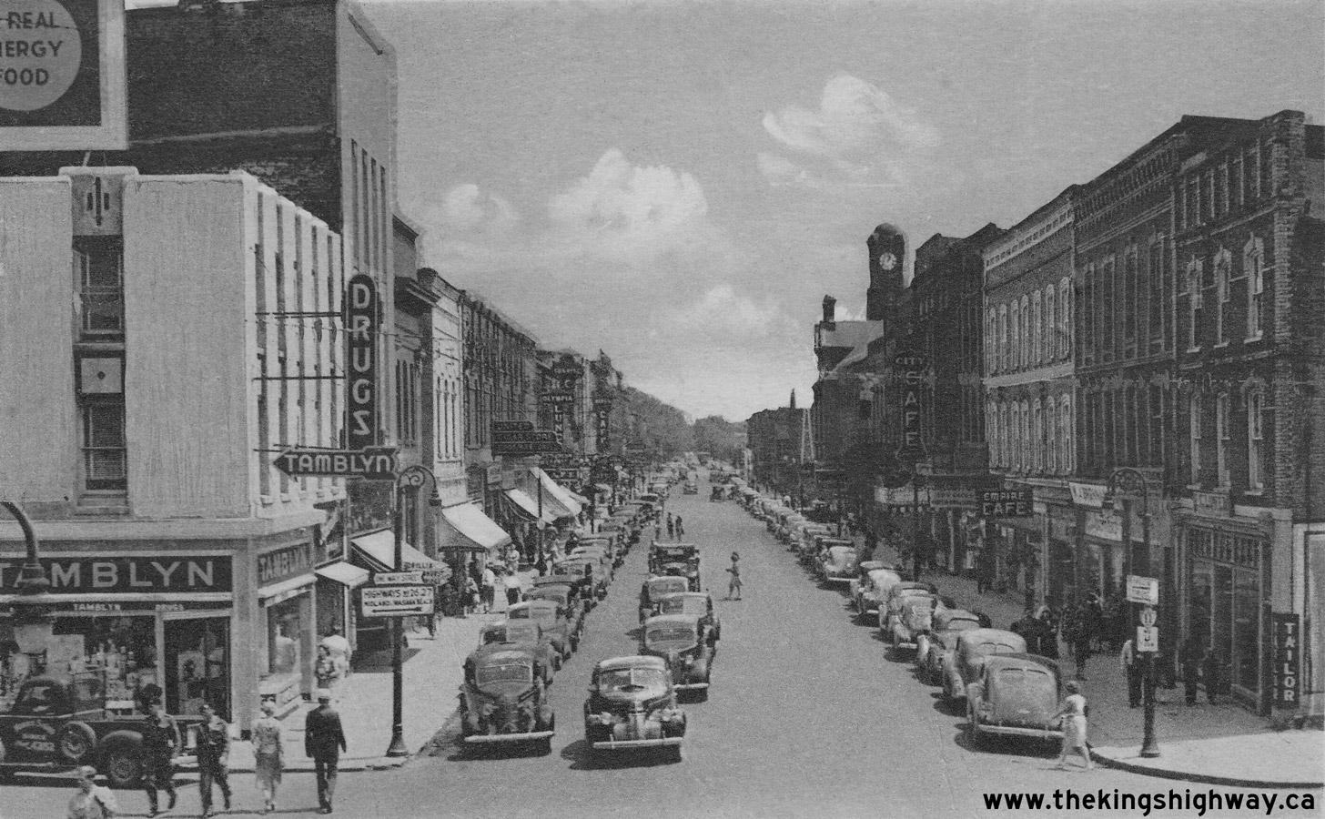
Above - Circa 1940 postcard view of Hwy 11 (Dunlop Street) in Downtown Barrie, facing east from the Hwy 26 & Hwy 27 Junction. See an
Enlarged Photo Here. (Photo courtesy of the Photogelatine Engraving Company Ltd, Ottawa) 
Above - Facing north along Main Street (Hwy 27, later known as Hwy 93) approaching Robert Street in Downtown Penetanguishene in 1941. The Hotel Brule beside
the highway at left operated until recent decades, although the building itself still stands today. Historically, the route of Hwy 27 ended at the Penetanguishene
Harbour Wharf at the bottom of the hill in the background. See an Enlarged Photo Here. Photo
taken in 1941. (Photo from Cameron Bevers' historical photograph collection - Original photographer unknown) 

Left - Paving operations on Hwy 27, 2 miles south of Kleinburg. Photo taken on July 25, 1949. (Photo courtesy of Ontario Ministry of Transportation - © King's Printer for Ontario, 1949) Right - Looking through the new Hwy 27 (Essa Road) underpass on Hwy 400 in Barrie. Photo taken on September 19, 1949. (Photo courtesy of Ontario Ministry of Transportation - © King's Printer for Ontario, 1949) 
Above - Facing west along the Queen Elizabeth Way towards Hamilton from the Hwy 27 Cloverleaf in Toronto. See an
Enlarged Photo Here. Photo taken on July 3, 1951. (Photo courtesy of Ontario Ministry of Transportation - © King's Printer for Ontario, 1951) 
Above - Aerial view of Hwy 27 in Toronto, facing south towards Dixon Road and the future site of the Toronto Bypass (Hwy 401) in 1953. This photo shows the
rural area around the intersection of Hwy 27 & Dixon Road before a cloverleaf was built here in 1956. Compare the 1953 photo above to this
1969 Photo, showing the same section of highway sixteen years later. See an
Enlarged Photo Here. Photo taken in October 1953. (Photo courtesy of Lockwood Survey Corporation) 
Above - Overpass construction at Burnhamthorpe Road and Hwy 27 in Toronto in 1953. The original two-lane Hwy 27 was expanded to a four-lane freeway in the
first half of the 1950s as part of the Toronto Bypass construction. Crossing roads such as Burnhamthorpe Road depicted above originally connected to Hwy 27 via
at-grade intersections. By 1955, all crossing traffic along Hwy 27 between the Queen Elizabeth Way Cloverleaf and Hwy 401 had been grade-separated. Local access
points were controlled through the construction of new service roads along both sides of the new freeway and new interchanges at major junctions. See an
Enlarged Photo Here. Photo
taken on October 13, 1953. (Photo courtesy of Ontario Ministry of Transportation - © King's Printer for Ontario, 1953) 
Left - Overpass construction at St. Clair Avenue West (today's Rathburn Road) and Hwy 27 in Toronto. See an
Enlarged Photo Here. Photo taken on October 13, 1953. (Photo courtesy of Ontario Ministry of Transportation - © King's Printer for Ontario, 1953) Right - Looking north along Hwy 400 approaching the Hwy 26 & Hwy 27 (Bayfield Street) Interchange in Barrie. Photo taken on November 5, 1953. (Photo courtesy of Ontario Ministry of Transportation - © King's Printer for Ontario, 1953) 
Above - Hwy 400 facing north approaching the Hwy 27 (Essa Road) Interchange in Barrie. Note the at-grade intersection at Innisfil Township Line 14 (today's
Little Avenue in Barrie) which once crossed Hwy 400 just south of the Hwy 27 Interchange. Although Hwy 400 was originally constructed with grade separations and
cloverleaf interchanges at the more heavily-trafficked crossing roads, several low-volume crossing roads along Hwy 400 between Toronto and Barrie had to be left as
at-grade intersections for several years due to shortages of structural steel and other construction materials following World War II. See an
Enlarged Photo Here. Photo taken on November 5, 1953. (Photo © Archives of Ontario - Series RG-14-162-5-163, Box B986, Photo #609) 

Left - New Mimico Creek arch culvert on the Toronto Bypass (Hwy 401) at the Hwy 27 Interchange. Photo taken on June 27, 1954. (Photo courtesy of Ontario Ministry of Transportation - © King's Printer for Ontario, 1954) Right - Aerial view of the Hwy 26 & Hwy 27 (Bayfield Street) Interchange on Hwy 400 in Barrie, facing south. Photo taken on July 9, 1954. (Photo courtesy of Ontario Ministry of Transportation - © King's Printer for Ontario, 1954) 

Left - Aerial photo showing the western end of the Toronto Bypass (Hwy 401) at the Hwy 27 Interchange in 1954. Hwy 401 ended here for several years in the
mid-1950s, before it was extended westerly towards Hwy 25 in Milton. The Richview Sideroad (today's Eglinton Avenue) passes across the right corner of this photo.
Photo taken on July 9, 1954. (Photo courtesy of Ontario Ministry of Transportation - © King's Printer for Ontario, 1954) Right - Aerial view of Hwy 27 facing south from the Hwy 401 Interchange. This great photograph shows the reconstruction of Hwy 27 as a freeway (today's Hwy 427) as it passes through a rural section of Etobicoke before urban sprawl completely devoured the area. The overpasses over Hwy 27 (from foreground to background) are the Toronto Bypass (Hwy 401, still under construction), Richview Sideroad (today's Eglinton Avenue), Rathburn Road, Burnhamthorpe Road, and Bloor Street. Today's Pearson Airport is located just off the photo to the right, and the massive Hwy 401 & Hwy 427 interchange is now located just to the right of the centre of this photo. See an Enlarged Photo Here. Photo taken on July 9, 1954. (Photo © Archives of Ontario - Series RG-14-162-2, Photo #550) 

Left - Aerial view of the Queen Elizabeth Way & Hwy 27 Cloverleaf in Toronto in 1954. Note the reconstruction along Hwy 27 North, which
eventually converted the two-lane highway into a freeway. This freeway was re-designated as Hwy 427 in 1972. Photo taken on July 9, 1954. (Photo courtesy of Ontario Ministry of Transportation - © King's Printer for Ontario, 1954) Right - Interchange construction at the western end of the Toronto Bypass (Hwy 401) at Hwy 27, facing north from the Richview Sideroad Overpass in 1954. This interesting photo shows the extension of the Toronto Bypass to Hwy 27 in the background and the reconstruction of existing Hwy 27 as a four-lane controlled-access freeway in the foreground. The completion and opening of the Hwy 401 & Hwy 27 Interchange in 1955 allowed long-distance through traffic to travel between Hwy 400 and the Queen Elizabeth Way without passing through a single set of traffic signals. Photo taken on October 7, 1954. (Photo courtesy of Ontario Ministry of Transportation - © King's Printer for Ontario, 1954) 
Above - Aerial view of Albion Road (Hwy 50) at the Hwy 27 Junction in 1954, facing southeast. Compare the 1954 photo above to this
1969 Photo, showing the same intersection amidst the rapidly developing area of Rexdale. Photo
taken in September 1954. See an Enlarged Photo Here. (Photo courtesy of Lockwood Survey Corporation) 
Above - Canadian Pacific Railway (CPR) grade separation under construction on the new freeway section of Hwy 27 in Toronto. See an
Enlarged Photo Here. Photo taken on September 3, 1954. (Photo courtesy of Ontario Ministry of Transportation - © King's Printer for Ontario, 2022) 

Left - North Queen Street Underpass under construction on the new freeway section of Hwy 27 in Toronto. See an
Enlarged Photo Here. Photo taken on September 3, 1954. (Photo courtesy of Ontario Ministry of Transportation - © King's Printer for Ontario, 2022) Right - Circa 1955 postcard view of the Hwy 400 and Hwy 27 (Essa Road) Interchange in Barrie (Photo courtesy of Alex Wilson Publishing Ltd.) 

Left - Completed western leg of the Toronto Bypass via Hwy 27 approaching St. Clair Avenue West (today's Rathburn Road) in Toronto in 1955. This rare early
photo of the completed freeway section of Hwy 27 shows the configuration of the original four-lane freeway and the two grade-separated service roads which paralleled
the highway. At first, traffic volumes on the western leg of the Toronto Bypass were quite low, but as Toronto grew, so did the traffic volumes. Fewer than 20,000
vehicles per day used Hwy 27 when this photo was taken in 1955, but by the end of the 1960s, traffic volumes on this section of Hwy 27 had climbed to nearly 75,000
vehicles per day - almost a four-fold increase! Construction got underway in 1968 to replace the original four-lane freeway with the complex freeway system that many
readers are likely more familiar with today between the Queen Elizabeth Way and Hwy 401. This section of Hwy 27 was renumbered as Hwy 427 in 1972. See an
Enlarged Photo Here. Photo taken on October 28, 1955. (Photo courtesy of Ontario Ministry of Transportation - © King's Printer for Ontario, 1955) Right - Ontario Coat-of-Arms stamp on the Bayfield Street Overpass (Hwy 26 & Hwy 27) on Hwy 400 in Barrie. Note the unusual median-mounted guide sign at right, reading "Hwy 26 & Hwy 27 Points West". See an Enlarged Photo Here. Photo taken on January 24, 1956. (Photo courtesy of Ontario Ministry of Transportation - © King's Printer for Ontario, 2013) 

Left - Facing east along Hwy 49 (Nashville Road) towards Kleinburg approaching the Hwy 27 Junction in 1956. At this junction, Hwy 49 continued into Kleinburg
east of Hwy 27, where the highway came to an end at Islington Avenue. Up until 1961, the Department of Highways of Ontario (DHO) had jurisdiction over the Nashville
Road between Hwy 50 near Bolton and Kleinburg. The Nashville Road was part of the historical Ontario highway route known as Hwy 49, which should not be confused with
the unrelated, present day route of Hwy 49 which is situated east of Belleville. See an
Enlarged Photo Here. Photo taken in Winter 1956. (Photo courtesy of Ontario Ministry of Transportation - © King's Printer for Ontario, 1956) Right - View of Hwy 27 at the Hwy 49 Junction in Kleinburg, facing north towards Barrie. See an Enlarged Photo Here. Photo taken in Winter 1956. (Photo courtesy of Ontario Ministry of Transportation - © King's Printer for Ontario, 1956) 

Left - Junction of Hwy 27 & Hwy 49 in Kleinburg in 1956, facing west towards Bolton. At the intersection, careful observers will note an octagonal Stop sign, with
the old regulatory message "THROUGH - STOP - HIGHWAY". The DHO adopted the Manual of Uniform Traffic Control Devices (MUTCD) along with most other North American road
agencies during the 1950s, which standardized all Stop signs to the red octagonal shape used today, with the word "STOP" in white text against a red background.
Historically, Stop signs on Ontario's highways were yellow with black text and were usually square-shaped. Sometimes, octagonal-shaped Stop signs were used with a
yellow background colour, like the example seen here. See an Enlarged Photo Here. Photo taken
in Winter 1956. (Photo courtesy of Ontario Ministry of Transportation - © King's Printer for Ontario, 1956) Right - Facing south along Hwy 27 at the Hwy 49 Junction in Kleinburg. Note that the destination "control city" signed along southbound Hwy 27 was actually Long Branch - an obsolete destination at the time this photo was taken in 1956. Numerous settlements, townships, incorporated villages, towns and cities were all amalgamated to form Metropolitan Toronto in 1953. However, it was not uncommon to see obsolete destinations such as Long Branch signed along Ontario's Highways until the late 1950s, when "Toronto" became the general destination control city for highway signing. See an Enlarged Photo Here. Photo taken in Winter 1956. (Photo courtesy of Ontario Ministry of Transportation - © King's Printer for Ontario, 1956) 

Left - Queen Elizabeth Way at the Hwy 27 Cloverleaf, facing east towards Toronto. Note that traffic entering the Queen Elizabeth Way from southbound Hwy 27 at
right was actually under Stop-control, as there was limited acceleration distance for motorists to merge into the freeway before the overpass. As a result, motorists
heading into Downtown Toronto had to stop and wait for a gap in traffic on the Queen Elizabeth Way before proceeding. The southern side of the Hwy 27 Cloverleaf was
reconstructed in 1957-1958 in order to make this a free-flow ramp. The northern half of the original 1940 Hwy 27 Cloverleaf was reconstructed in 1955 as part of the
freeway conversion of Hwy 27 to the north of the Queen Elizabeth Way. See an
Enlarged Photo Here. Photo taken on July 12, 1956. (Photo courtesy of Ontario Ministry of Transportation - © King's Printer for Ontario, 1956) Right - New Woodbine Racetrack Interchange on Hwy 27 in Toronto, facing north towards Woodbridge. See an Enlarged Photo Here. Photo taken on November 7, 1956. (Photo courtesy of Ontario Ministry of Transportation - © King's Printer for Ontario, 1956) 
Above - Resurfaced section of Hwy 27 facing north from the Hwy 49 Junction at Kleinburg, Contract #1956-130. See an
Enlarged Photo Here. Photo taken on November 7, 1956. (Photo courtesy of Ontario Ministry of Transportation - © King's Printer for Ontario, 1956) 
Above - Construction progress on the Hwy 27 & Hwy 401 Interchange in Toronto in 1958, facing south along Hwy 27 from the westbound Hwy 401 structure. Note the start of
the divided highway in the distance. The extension of Hwy 401 westerly from Toronto towards Milton resulted in numerous retrofits to the Hwy 27 Interchange, including
the construction of a left-hand exit ramp from eastbound Hwy 401 to northbound Hwy 27. This ramp was closed permanently during reconstruction of this interchange in
1970. Photo taken in 1958. (Photo courtesy of Ontario Ministry of Transportation - © King's Printer for Ontario, 1958) 

Left - Aerial view of a traffic jam on Hwy 401 in Toronto, facing west towards the Hwy 27 Interchange. See an
Enlarged Photo Here. Photo taken on June 17, 1959. (Photo © Archives of Ontario - Series RG-14-151-5-26, Box B1106, Photo #ES12-712) Right - Aerial view of a traffic jam on Hwy 401, facing northeast from the Hwy 27 Interchange in Toronto in 1959. The bizarre ramp configuration of the Hwy 27 and Hwy 401 Interchange is clearly visible in this photo. The ramp from eastbound Hwy 401 to northbound Hwy 27 was originally a left-hand exit. This ramp also had a direct merge onto northbound Hwy 27 with no acceleration lane, suggesting that this ramp connection was an afterthought conceived very late in the planning phase after the westbound Hwy 401 structure had been built. Beyond the westbound Hwy 401 structure, a direct taper loop ramp exited from northbound Hwy 27 to westbound Hwy 401. This unorthodox interchange existed up until the early 1970s, when the Hwy 27 Interchange was removed in order to accommodate the new freeway connection to Hwy 427. See an Enlarged Photo Here. Photo taken on June 17, 1959. (Photo © Archives of Ontario - Series RG-14-151-5-26, Box B1106, Photo #ES12-711) 
Above - Hwy 401 and Hwy 27 Interchange, facing north along Hwy 27 from the Richview Sideroad Overpass in 1959. This photo provides an interesting view of the
Hwy 27 Freeway as it approaches the Hwy 401 Interchange in Toronto. Due to the complex exit ramp configuration at this interchange, a large overhead sign structure
was placed above the highway to guide traffic. At the time this sign structure was installed in 1958, it was the largest of its kind in the province. See an
Enlarged Photo Here. Photo taken on November 12, 1959. (Photo © Archives of Ontario - Series RG-14-162-2-27, Box B983, Photo #1169C) 

Left - Aerial view of the Queen Elizabeth Way & Hwy 27 Cloverleaf in Toronto, looking north along Hwy 27. See an
Enlarged Photo Here. Photo taken in June 1960. (Photo © Archives of Ontario - RG-14-151-5-26, Photo #ES-13-894) Right - Aerial view of the Queen Elizabeth Way & Hwy 27 Cloverleaf in Toronto, looking northwest in 1960. This wonderful photo shows the entire area around the Queen Elizabeth Way & Hwy 27 (now Hwy 427) Interchange, including the open farm fields just beyond the cloverleaf. This is where the Sherway Gardens Shopping Centre is located today. A cloverleaf interchange had existed at the intersection of these two highways since 1940. When Hwy 27 was reconstructed and widened to four lanes in the mid-1950s, the ramps of the cloverleaf were completely realigned. The inner loop ramps were enlarged to smooth traffic flow, particularly for the heavily-traveled Toronto-bound Queen Elizabeth Way to northbound Hwy 27 inner loop ramp in the foreground. Note the size of this loop ramp compared to those found in the other three interchange quadrants. The increased size of this loop ramp provided a greater distance for traffic to merge on and off the loop ramp from the mainline freeway. Although the retrofits to the interchange made between 1955 and 1958 were a vast improvement over the original 1940 cloverleaf, the interchange still experienced significant congestion at peak times. The cloverleaf interchange at Hwy 27 was completely replaced by the current four-level interchange in the late 1960s. See an Enlarged Photo Here. Photo taken in June 1960. (Photo © Archives of Ontario - RG-14-151-5-26, Photo #ES-13-892) 
Above - Circa 1960 postcard view of Dunlop Street (Hwy 11) facing east from the Hwy 26 & Hwy 27 Junction in Downtown Barrie. This interesting photo shows
the "five points" intersection in the City Centre, with the traffic signals operating in an "All Red" phase to allow exclusive pedestrian movements. The completion of
the Barrie Bypass (Hwy 400) during the Summer of 1952 relieved Downtown Barrie of the burdensome long-distance through traffic which once clogged the city centre. Two
of the province's major north-south highways (Hwy 11 and Hwy 27) converged into a single overlapped route through Barrie. See an
Enlarged Photo Here. (Photo courtesy of Norman Sanderson) 
Above - Canadian Pacific Railway (CPR) Overhead on Hwy 27 between the Queen Elizabeth Way and Hwy 5 Interchanges in Toronto. See an
Enlarged Photo Here. Photo taken in May 1962. (Photo courtesy of Ontario Ministry of Transportation - © King's Printer for Ontario, 2022) 

Left - Facing south along Bayfield Street (Hwy 26 & Hwy 27) at the Hwy 400 Interchange in Barrie. See an
Enlarged Photo Here. Photo taken on May 30, 1962. (Photo courtesy of Ontario Ministry of Transportation - © King's Printer for Ontario, 2019) Right - Bayfield Street (Hwy 26 & Hwy 27) Overpass at the Hwy 400 Interchange in Barrie. See an Enlarged Photo Here. Photo taken on May 30, 1962. (Photo courtesy of Ontario Ministry of Transportation - © King's Printer for Ontario, 2019) 
Above - Map showing the proposed route of the Airport Expressway (part of today's Hwy 427) and other improved road links from Hwy 27 and Hwy 401 to Toronto
International Airport. The new Airport Expressway was completed and officially opened to traffic on January 3, 1964. See an
Enlarged Photo Here. (Photo courtesy of Ontario Ministry of Transportation - © King's Printer for Ontario, 1963) 
Above - Reconstruction and widening of the Malton Airport Road connection to Hwy 27, Contract #1962-267. See an
Enlarged Photo Here. Photo taken in 1963. (Photo courtesy of Ontario Ministry of Transportation - © King's Printer for Ontario, 1963) 
Above - Circa 1965 postcard view of Dunlop Street in Downtown Barrie at the Junction of Hwy 11, Hwy 27 & Hwy 90. See an
Enlarged Photo Here. (Photo courtesy of Stewart Wholesale Co. Ltd.) 

Left - Facing north along Hwy 27 towards Elmvale at the Canadian Pacific (CP) Railway Crossing north of Midhurst in 1967. Until a grade separation was built in
the early 1970s, Hwy 27 crossed this railway at-grade. See an Enlarged Photo Here. Photo taken
in April 1967. (Photo courtesy of Ontario Ministry of Transportation - © King's Printer for Ontario, 2015) Right - Approaching the Canadian Pacific Railway Crossing at Hwy 27 north of Midhurst in 1967. A grade separation was built in the foreground a few years after this photo was taken, in order to carry Hwy 27 below the railway. See an Enlarged Photo Here. Photo taken in April 1967. (Photo courtesy of Ontario Ministry of Transportation - © King's Printer for Ontario, 2015) 

Left - Facing southwest along the Canadian Pacific Railway from Hwy 27 near Midhurst in 1967, showing the site of the proposed grade separation. See an
Enlarged Photo Here. Photo taken in April 1967. (Photo courtesy of Ontario Ministry of Transportation - © King's Printer for Ontario, 2015) Right - Facing south along Hwy 27 towards Barrie at the Canadian Pacific Railway Crossing near Midhurst in 1967. The section of Hwy 27 visible here was bypassed during the construction of a grade separation in the early 1970s. See an Enlarged Photo Here. Photo taken in April 1967. (Photo courtesy of Ontario Ministry of Transportation - © King's Printer for Ontario, 2015) 
Above - Facing north along Hwy 400 across the Hwy 27 (Essa Road) Underpasses in Barrie in 1967. When Hwy 400 was widened to six lanes through Barrie in
1971-1972, the highway's grass median was filled in and the Hwy 27 Underpasses were spliced together to form one structure in order to accommodate the extra freeway
lanes. Photo taken in August 1967. (Photo courtesy of Ontario Ministry of Transportation - © King's Printer for Ontario, 2010) 

Left - Facing north along Hwy 27 (Essa Road) towards the dual Hwy 400 Underpasses in Barrie. Photo taken in August 1967. (Photo courtesy of Ontario Ministry of Transportation - © King's Printer for Ontario, 2010) Right - Reconstruction and widening of Hwy 27 north of the Hwy 26 Junction at Midhurst, Contract #1967-69. See an Enlarged Photo Here. Photo taken in 1967. (Photo courtesy of Ontario Ministry of Transportation - © King's Printer for Ontario, 1967) 

Left - Aerial plan of a proposed Hwy 27 subway underneath the CPR north of Midhurst (1969) (Photo courtesy of Ontario Ministry of Transportation - © King's Printer for Ontario, 2013) Right - Aerial plan of a proposed Hwy 27 diversion at Simcoe Road 22 (1969) (Photo courtesy of Ontario Ministry of Transportation - © King's Printer for Ontario, 2013) 
Above - Aerial view of construction progress on the new multi-level Hwy 27 (later Hwy 427) Interchange on the Queen Elizabeth Way, facing north from Evans
Avenue (1969) (Photo courtesy of Ontario Ministry of Transportation - © King's Printer for Ontario, 1969) 
Above - Aerial view of the Hwy 27 Interchange on the Queen Elizabeth Way in Toronto in 1969, facing west. This interesting photo shows the new multi-level
interchange at Hwy 27 (today's Hwy 427) under construction. The original 1940 overpass and the two south loop ramps of the old Hwy 27 cloverleaf remained in service
at the time this photo was taken. Note the preparation of the massive Queen Elizabeth Way diversion along what is now the Queensway. During some stages of the
interchange's construction, a temporary relocation of the Queen Elizabeth Way to the north was required. The temporary diversion was built in order to facilitate the
removal of the old 1940 overpass and the construction of the new post-tensioned concrete directional flyovers to replace the old cloverleaf loop ramps. Following the
completion of the multi-level interchange at Hwy 27, the temporary Queen Elizabeth Way diversion was removed and the Queensway was reopened to local traffic. See an
Enlarged Photo Here. Photo taken in April 1969. (Photo courtesy of Lockwood Survey Corporation) 

Left - Aerial view of Hwy 27 in Toronto, facing south towards Dixon Road and Hwy 401 in 1969. Compare the 1969 photo above to this
1953 Photo, showing the same section of highway before this part of Etobicoke was urbanized.
Note that construction had not yet begun on Hwy 409 parallel to Belfield Road in the foreground. Work got underway on Hwy 409 a few years after this photo was taken.
See an Enlarged Photo Here. Photo taken in April 1969. (Photo courtesy of Lockwood Survey Corporation) Right - Aerial view of Albion Road (Hwy 50) at the Hwy 27 Junction in 1969, facing southeast. Compare the 1969 photo above to this 1954 Photo, showing the same intersection fifteen years earlier before urban development began to take hold. See an Enlarged Photo Here. Photo taken in April 1969. (Photo courtesy of Lockwood Survey Corporation)
Continue on to King's Highway 27 Photos: Historical Photos: 1970 to 1999
|
|---|
Links to Adjacent King's Highway Photograph Pages:
Back to King's Highway 26 Photos /
King's Highway 27 History /
On to King's Highway 28 Photos
Ontario Highway History - Main Menu / Back to List of Highways Website contents, photos & text © 2002-2026, Cameron
Bevers (Webmaster) - All Rights Reserved / Contact Me
|
|---|