
| 
| |
|
|
This page contains historical photos of Ontario's King's Highway 28 dating from 1928 to 1999. All photographs displayed on
this page were taken by the Ontario Ministry of Transportation, unless specifically noted otherwise. Historical photographs are arranged in approximate chronological
order. Click on any thumbnail to see a larger image!
Please note that all photographs displayed on this
website are protected by copyright. These photographs must not be reproduced, published,
electronically stored or copied, distributed, or posted onto other websites without
my written permission. If you want to use photos from this website, please
email me first for permission. Thank-you!
|
|---|
|
Page 1: Historical King's Highway 28 Photographs (1928-1999)


Left - New twin-slab concrete pavement on Hwy 28, 1 mile south of Lakefield in 1934. Immediately after the section of Hwy 28 between Peterborough and Lakefield
was assumed by the Department of Highways of Ontario (DHO) in 1934, about 6 miles of concrete pavement was constructed along the route under Contract #1934-05. See an
Enlarged Photo Here. Photo taken in 1934. (Photo courtesy of Ontario Ministry of Transportation - © King's Printer for Ontario, 1934)  Right - View of a concrete-surfaced section along Hwy 28, located about 6 miles north of Port Hope in 1940. This early photo of Hwy 28 shows the cross section
of a typical King's Highway of the era, with a paved road surface with a width of 20 feet and grass shoulders. The concrete pavement along this section of the highway
was constructed in 1928, 12 years before this photo was taken. This section of Hwy 28 was bypassed by a new straighter route during the 1970s. Since the old highway
was left behind, the road's geometry was never modified although it was ultimately resurfaced with an asphalt top course. This view can be found on Rice Lake Drive
(Old Hwy 28) south of Bewdley, where the road still looks quite similar even today. See an
Enlarged Photo Here. Photo taken on September 23, 1940. Right - View of a concrete-surfaced section along Hwy 28, located about 6 miles north of Port Hope in 1940. This early photo of Hwy 28 shows the cross section
of a typical King's Highway of the era, with a paved road surface with a width of 20 feet and grass shoulders. The concrete pavement along this section of the highway
was constructed in 1928, 12 years before this photo was taken. This section of Hwy 28 was bypassed by a new straighter route during the 1970s. Since the old highway
was left behind, the road's geometry was never modified although it was ultimately resurfaced with an asphalt top course. This view can be found on Rice Lake Drive
(Old Hwy 28) south of Bewdley, where the road still looks quite similar even today. See an
Enlarged Photo Here. Photo taken on September 23, 1940.(Photo © Archives of Ontario - RG-14-162-3, Cont. A1355, Photo #3410S) 
Above - Circa 1940 postcard view of Hwy 28 near Bewdley. Note the mature trees lining both sides of the highway, which were removed during various highway
safety improvement projects in the 1950s and 1960s. See an Enlarged Photo Here. Photo taken
circa 1940. (Photo from Cameron Bevers' historical photograph collection - Original photographer unknown) 
 Left - New bituminous prime surface treatment along a section of Hwy 28 approaching the Eels Creek Bridge at Haultain, located about 10 miles south of Apsley.
During 1940, the gravel-surfaced highway between Lakefield and Apsley was surface-treated using an M.C.1 asphalt prime for a total distance of about 27 miles. The
resulting highway surface offered a somewhat smoother and more stable ride for motorists using Hwy 28 than the previous untreated gravel surface. These treated
surfaces also helped to control the dust clouds which were often stirred up by vehicles travelling along untreated gravel highways. See an
Enlarged Photo Here. Photo taken on September 23, 1940. Left - New bituminous prime surface treatment along a section of Hwy 28 approaching the Eels Creek Bridge at Haultain, located about 10 miles south of Apsley.
During 1940, the gravel-surfaced highway between Lakefield and Apsley was surface-treated using an M.C.1 asphalt prime for a total distance of about 27 miles. The
resulting highway surface offered a somewhat smoother and more stable ride for motorists using Hwy 28 than the previous untreated gravel surface. These treated
surfaces also helped to control the dust clouds which were often stirred up by vehicles travelling along untreated gravel highways. See an
Enlarged Photo Here. Photo taken on September 23, 1940.(Photo courtesy of Ontario Ministry of Transportation - © King's Printer for Ontario, 1940) Right - Newly-completed section of Hwy 28 in 1943, facing south towards Apsley at the Peterborough County Boundary. The extension of Hwy 28 from Apsley to Bancroft in 1943 was one of the only new highways completed in Ontario during World War II. Highway construction during World War II was extremely difficult, due to chronic shortages of construction equipment, labour and Wartime rationing of fuel and other materials. The section of Hwy 28 seen here remained gravel-surfaced for a number of years, until the highway was paved in the early 1950s. See an Enlarged Photo Here. Photo taken in 1943. (Photo courtesy of Ontario Ministry of Transportation - © King's Printer for Ontario, 1943) 
Above - Circa 1945 postcard view of Hwy 28 approaching the Crowe River Bridge at Paudash, facing north towards Bancroft. Note the log guide rail beside the
highway. Log guide rails such as this were commonly used along highways in Northern and Central Ontario in the 1930s and 1940s, since the timber was readily available
nearby and the guide rails required few manufactured parts for assembly. See an
Enlarged Photo Here. Photo taken circa 1945. (Photo from Cameron Bevers' historical photograph collection - Original photographer unknown) 
Above - Circa 1950 postcard view of the old York River Bridge on Hwy 62 in Bancroft. This historic concrete arch structure was built in 1913. The bridge was
quite narrow and was difficult for trucks to negotiate, especially at the Hwy 28 Junction which lay at the western end of the bridge. The old arch bridge was
replaced by the current Hwy 62 bridge in 1965. See an Enlarged Photo Here. Photo taken circa
1950. (Photo courtesy of the Gazette Publishing Company, Picton) 
 Left - Junction sign assembly in front of the Bancroft Theatre on Bridge Street (Hwy 62) approaching the Hwy 28 Junction in Bancroft in 1950. Note the unusual
"Straight Ahead" tab below the Hwy 28 route marker. These sign tabs were used in lieu of a through arrow at early highway junction sign assemblies. For many years in
fact, arrows were not used at all on the "advance" junction sign assembly in Ontario. Small "L" and "R" shields used to be placed below the highway route marker to
indicate whether the highway turned to the left or right at an upcoming intersection. See an
Enlarged Photo Here. Photo taken in 1950. Left - Junction sign assembly in front of the Bancroft Theatre on Bridge Street (Hwy 62) approaching the Hwy 28 Junction in Bancroft in 1950. Note the unusual
"Straight Ahead" tab below the Hwy 28 route marker. These sign tabs were used in lieu of a through arrow at early highway junction sign assemblies. For many years in
fact, arrows were not used at all on the "advance" junction sign assembly in Ontario. Small "L" and "R" shields used to be placed below the highway route marker to
indicate whether the highway turned to the left or right at an upcoming intersection. See an
Enlarged Photo Here. Photo taken in 1950.(Photo © Archives of Ontario - Series RG-56-11, Photo #I-0027139) Right - Tree-lined view of Hwy 28 about 1 mile south of Bewdley in 1950, showing new pavement zone striping. Prior to World War II, pavement markings were used
quite sparingly in Ontario and were only applied in specific situations where additional guidance to motorists was deemed necessary. Following the outbreak of war in
1939, materials and equipment needed to manufacture and apply highway paint were suddenly in short supply and the practice of striping pavements was greatly reduced.
As shortages of paint eased after World War II, the DHO began to actively stripe passing zones and centrelines along most of Ontario's King's Highways as an
additional safety measure. In this photo, two motorists travelling in opposite directions safely pass by one another with each highway lane clearly delineated. See an
Enlarged Photo Here. Photo taken on June 23, 1950.(Photo courtesy of Ontario Ministry of Transportation - © King's Printer for Ontario, 1950) 
 Left - View of the new intersection channelizations constructed at the junction of Hwy 28 and the Welcome-Dale Cut-Off Highway (later known as Hwy 106) at
Dale, facing south towards Port Hope in 1951. Under Contract #1951-381, both Hwy 28 and the Welcome-Dale Cut-Off Highway were resurfaced with hot-mix asphalt. New
right-turn channels were also built at this well-used highway junction to allow traffic to easily pass between Hwy 28 and nearby Hwy 2. Prior to the completion of
Hwy 115 in 1954, virtually all traffic travelling between Toronto and Peterborough had to pass through this junction. In this photo, the Welcome-Dale Cut-Off Highway
is signed using a Hwy 2 route marker and a right-pointing arrow, even though the cut-off itself was never considered to be a part of Hwy 2. The Welcome-Dale Cut-Off
Highway did not have its own unique route number until 1953, when the Hwy 106 designation was introduced along this short but important cut-off route. See an
Enlarged Photo Here. Photo taken on December 12, 1951. Left - View of the new intersection channelizations constructed at the junction of Hwy 28 and the Welcome-Dale Cut-Off Highway (later known as Hwy 106) at
Dale, facing south towards Port Hope in 1951. Under Contract #1951-381, both Hwy 28 and the Welcome-Dale Cut-Off Highway were resurfaced with hot-mix asphalt. New
right-turn channels were also built at this well-used highway junction to allow traffic to easily pass between Hwy 28 and nearby Hwy 2. Prior to the completion of
Hwy 115 in 1954, virtually all traffic travelling between Toronto and Peterborough had to pass through this junction. In this photo, the Welcome-Dale Cut-Off Highway
is signed using a Hwy 2 route marker and a right-pointing arrow, even though the cut-off itself was never considered to be a part of Hwy 2. The Welcome-Dale Cut-Off
Highway did not have its own unique route number until 1953, when the Hwy 106 designation was introduced along this short but important cut-off route. See an
Enlarged Photo Here. Photo taken on December 12, 1951.(Photo courtesy of Ontario Ministry of Transportation - © King's Printer for Ontario, 1951) Right - Department of Highways' Sign Truck at the Port Hope District Garage. See an Enlarged Photo Here. Photo taken on July 17, 1952. (Photo courtesy of Ontario Ministry of Transportation - © King's Printer for Ontario, 1952)  Above - Pavement conditions along Hwy 28, about 1 mile south of Burleigh Falls in 1952. A mulch asphalt surface was laid by DHO divisional forces in 1949
between Lakefield and Burleigh Falls. While relatively inexpensive to construct, mulch asphalt surfaces generally didn't have the longevity of stronger hot-mix
asphalt pavement designs. Mulch asphalt pavements were more prone to seasonal frost-heaving and were often battered by heavy truck traffic. However, these inexpensive
pavements did serve their purpose as Ontario struggled to keep up with a lengthy backlog of highway improvement needs in the years following World War II. With
traffic volumes skyrocketing each year, DHO was often forced to do interim improvements to highways until such time that full reconstruction of the highway was
feasible. See an Enlarged Photo Here. Photo taken on September 20, 1952. Above - Pavement conditions along Hwy 28, about 1 mile south of Burleigh Falls in 1952. A mulch asphalt surface was laid by DHO divisional forces in 1949
between Lakefield and Burleigh Falls. While relatively inexpensive to construct, mulch asphalt surfaces generally didn't have the longevity of stronger hot-mix
asphalt pavement designs. Mulch asphalt pavements were more prone to seasonal frost-heaving and were often battered by heavy truck traffic. However, these inexpensive
pavements did serve their purpose as Ontario struggled to keep up with a lengthy backlog of highway improvement needs in the years following World War II. With
traffic volumes skyrocketing each year, DHO was often forced to do interim improvements to highways until such time that full reconstruction of the highway was
feasible. See an Enlarged Photo Here. Photo taken on September 20, 1952.(Photo courtesy of Ontario Ministry of Transportation - © King's Printer for Ontario, 1952) 
 Left - Completed mulch asphalt and zone striping along Hwy 28, about 11 miles south of Bancroft. During 1952, Hwy 28 was surfaced with mulch asphalt for a
distance of about 21 miles from Apsley northerly to Paudash by DHO District #10 (Bancroft) divisional forces. Note the small lay-by beside the highway at left, which
served as a parking area for DHO's diminutive Roadside Park at Paudash Lake. Although the park at Paudash Lake closed many years ago, the lay-by and stone retaining
wall is still visible along Hwy 28 today. See an Enlarged Photo Here. Photo taken on October
22, 1952. Left - Completed mulch asphalt and zone striping along Hwy 28, about 11 miles south of Bancroft. During 1952, Hwy 28 was surfaced with mulch asphalt for a
distance of about 21 miles from Apsley northerly to Paudash by DHO District #10 (Bancroft) divisional forces. Note the small lay-by beside the highway at left, which
served as a parking area for DHO's diminutive Roadside Park at Paudash Lake. Although the park at Paudash Lake closed many years ago, the lay-by and stone retaining
wall is still visible along Hwy 28 today. See an Enlarged Photo Here. Photo taken on October
22, 1952.(Photo courtesy of Ontario Ministry of Transportation - © King's Printer for Ontario, 1952) Right - View of the Paudash Lake Roadside Park on Hwy 28, about 11 miles south of Bancroft. At the time this photo was taken in 1952, this was the smallest of
DHO's roadside parks, with a total park size of about a half-acre. The park had a small number of picnic tables, a stone cooking stove and a handful of waterfront
campsites. Due to the park's small size, camping was prohibited within the park by the late 1950s to prevent overcrowding. See an
Enlarged Photo Here. Photo taken on October 22, 1952.(Photo courtesy of Ontario Ministry of Transportation - © King's Printer for Ontario, 1952)  Above - View of a construction crew preparing to widen a rock cut along Hwy 28, about 5 miles north of Burleigh Falls in 1952. Under Contract #1951-27, about
6 1/2 miles of Hwy 28 were improved through the widening of rock cuts, removal of curves and resetting of the highway's vertical profile. While it was common for DHO
to contract out larger highway projects to private construction companies, the DHO still used its own divisional forces to complete less complex highway grading and
paving activities. In some cases, the DHO would even hire local labourers on a day-to-day basis to complete small construction projects, particularly in Northern and
Central Ontario. See an Enlarged Photo Here. Photo taken on October 22, 1952. Above - View of a construction crew preparing to widen a rock cut along Hwy 28, about 5 miles north of Burleigh Falls in 1952. Under Contract #1951-27, about
6 1/2 miles of Hwy 28 were improved through the widening of rock cuts, removal of curves and resetting of the highway's vertical profile. While it was common for DHO
to contract out larger highway projects to private construction companies, the DHO still used its own divisional forces to complete less complex highway grading and
paving activities. In some cases, the DHO would even hire local labourers on a day-to-day basis to complete small construction projects, particularly in Northern and
Central Ontario. See an Enlarged Photo Here. Photo taken on October 22, 1952.(Photo courtesy of Ontario Ministry of Transportation - © King's Printer for Ontario, 1952) 
 Left - Old Youngs Point Bridge over the Otonabee River on Hwy 28 in 1953. This narrow 19th-Century structure was bypassed by a new high-level bridge which
spanned both the Otonabee River and the Trent-Severn Waterway in 1954. See an
Enlarged Photo Here. Photo taken on July 17, 1953. Left - Old Youngs Point Bridge over the Otonabee River on Hwy 28 in 1953. This narrow 19th-Century structure was bypassed by a new high-level bridge which
spanned both the Otonabee River and the Trent-Severn Waterway in 1954. See an
Enlarged Photo Here. Photo taken on July 17, 1953.(Photo courtesy of Ontario Ministry of Transportation - © King's Printer for Ontario, 1953) Right - View of the realignment of Hwy 28 at the Eels Creek Bridge at Haultain, Contract #1952-29. Interestingly, the old steel truss bridge which once carried Hwy 28 was salvaged from the Haultain
site shortly after this photo was taken. The steel truss bridge was then reassembled at a new site at
the Crowe River on the Chandos Loop Road (Hwy 504) east of Apsley in 1953-1954. Structural steel was in very short supply after World War II and during the Korean
War, which made bridge salvaging operations such as this a necessity in order to keep pace with Ontario's growing highway infrastructure needs. See an
Enlarged Photo Here. Photo taken on October 9, 1953.(Photo courtesy of Ontario Ministry of Transportation - © King's Printer for Ontario, 1953) 
Above - South Burleigh Falls Bridge on Hwy 28 under construction in 1953, Contract #1953-05. The South Burleigh Falls Bridge replacement was the first of
several contracts awarded in the 1950s and 1960s to reconstruct Hwy 28 through Burleigh Falls on an improved alignment. Several narrow bridges were replaced at
Burleigh Falls in the process. See an
Enlarged Photo Here. Photo taken on October 9, 1953. (Photo courtesy of Ontario Ministry of Transportation - © King's Printer for Ontario, 1953) 
 Left - Completed South Burleigh Falls Bridge on Hwy 28 in 1954. Constructed under Contract #1953-05, this was the first of several bridge replacements which
took place along Hwy 28 at Burleigh Falls. This bridge spans the Burleigh River and consists of three concrete "T"-beam spans. The previous bridge over the Burleigh
River was an iron through truss structure. See an Enlarged Photo Here. Photo taken on July 28,
1954. Left - Completed South Burleigh Falls Bridge on Hwy 28 in 1954. Constructed under Contract #1953-05, this was the first of several bridge replacements which
took place along Hwy 28 at Burleigh Falls. This bridge spans the Burleigh River and consists of three concrete "T"-beam spans. The previous bridge over the Burleigh
River was an iron through truss structure. See an Enlarged Photo Here. Photo taken on July 28,
1954.(Photo courtesy of Ontario Ministry of Transportation - © King's Printer for Ontario, 1954) Right - Grading along Hwy 28 south of Apsley under Contract #1954-21, facing south from Sta. 427+50. During the 1950s, many older sections of Hwy 28 south of
Apsley were improved by relocating the highway onto a revised alignment. These improvements removed sharp curves and steep grades on the original highway's alignment.
The revised highway grade offered motorists with increased sight distance of the road ahead and thus facilitated passing. Prior to the highway's reconstruction, it
would been extremely difficult to pass a slow-moving vehicle along this section of Hwy 28, due to the highway's winding alignment. See an
Enlarged Photo Here. Photo taken on August 25, 1954.(Photo courtesy of Ontario Ministry of Transportation - © King's Printer for Ontario, 1954) 
 Left - New Eels Creek Bridge (the Parks Bridge) on Hwy 28 between Haultain and Apsley, Contract #1953-06. See an
Enlarged Photo Here. Photo taken on August 25, 1954. Left - New Eels Creek Bridge (the Parks Bridge) on Hwy 28 between Haultain and Apsley, Contract #1953-06. See an
Enlarged Photo Here. Photo taken on August 25, 1954.(Photo courtesy of Ontario Ministry of Transportation - © King's Printer for Ontario, 1954) Right - New high-level bridge for Hwy 28 over the Otonabee River and the Trent-Severn Waterway at Youngs Point, Contract #1953-04. See an
Enlarged Photo Here. Photo taken on June 29, 1955.(Photo courtesy of Ontario Ministry of Transportation - © King's Printer for Ontario, 1955) 

Left - View of Rice Lake from Hwy 28 near Bewdley in 1955. Note the old dual cable and cedar post guide rail beside the highway. This early example of a
roadside hazard protection system likely dates from the mid-1920s, when this design started to see widespread use on Ontario's provincial highways. See an
Enlarged Photo Here. Photo taken on June 10, 1955. (Photo courtesy of Ontario Ministry of Transportation - © King's Printer for Ontario, 1955) Right - Youngs Point Lock on the Trent-Severn Waterway north of Lakefield in 1955. Up until 1954, all Hwy 28 traffic had to cross the Youngs Point Lock via a narrow turn-of-the-century swing bridge. A new high-level bridge was completed across the channel at Youngs Point in 1954. The new high-level bridge greatly improved traffic flow on Hwy 28, since the new bridge allowed highway traffic to cross the channel uninterrupted by marine traffic on the canal below. The old Hwy 28 swing bridge can be seen in the background of this photo. See an Enlarged Photo Here. Photo taken on July 13, 1955. (Photo courtesy of Ontario Ministry of Transportation - © King's Printer for Ontario, 1955)  Above - Hot-mix paving on Hwy 28 south of Apsley at Sta. 168+00, Contract #1955-53. See an
Enlarged Photo Here. Photo taken on July 14, 1955. Above - Hot-mix paving on Hwy 28 south of Apsley at Sta. 168+00, Contract #1955-53. See an
Enlarged Photo Here. Photo taken on July 14, 1955.(Photo courtesy of Ontario Ministry of Transportation - © King's Printer for Ontario, 1955) 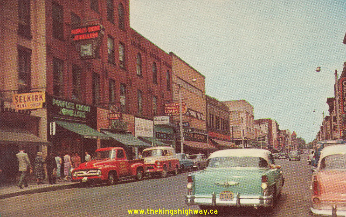

Left - Postcard view of Hwy 7 (George Street) in Downtown Peterborough in 1956, facing north from the Hwy 28 Junction at Charlotte Street. This interesting
photo shows George Street just before the one-way street system was introduced through Downtown Peterborough in the late 1950s. Today, George Street carries
southbound traffic only, while northbound traffic follows adjacent Water Street through the city centre. See an
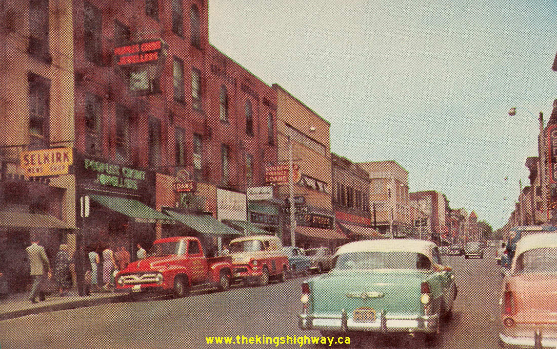
Enlarged Photo Here. Photo taken in 1956. (Photo courtesy of Royal Specialty Sales, Toronto) Right - Circa 1957 postcard view of Hastings Street (Hwy 62) in Downtown Bancroft, facing north from the Hwy 500 Junction (later known as Hwy 28). See an Enlarged Photo Here. (Photo courtesy of the Canadian Post Card Company, Ltd. Toronto) 
Above - Preparation for the blasting of a new rock cut on a diversion of Hwy 28 (then known as Hwy 500) between Hermon and McArthur Mills east of Bancroft,
Contract #1962-33. The section of Hwy 500 lying east of Bancroft became an extension of Hwy 28 in 1982. See an
Enlarged Photo Here. Photo taken in 1962. (Photo courtesy of Ontario Ministry of Transportation - © King's Printer for Ontario, 1962)  Above - DHO District #10 (Bancroft) Office on Hwy 28. See an
Enlarged Photo Here. Photo taken in 1966. Above - DHO District #10 (Bancroft) Office on Hwy 28. See an
Enlarged Photo Here. Photo taken in 1966.(Photo courtesy of Ontario Ministry of Transportation - © King's Printer for Ontario, 1966)  Above - Interchange construction at the Hwy 28 & Hwy 115 Junction southwest of Peterborough, Contract #1966-60. See an
Enlarged Photo Here. Photo taken in 1966. Above - Interchange construction at the Hwy 28 & Hwy 115 Junction southwest of Peterborough, Contract #1966-60. See an
Enlarged Photo Here. Photo taken in 1966.(Photo courtesy of Ontario Ministry of Transportation - © King's Printer for Ontario, 1966)  Above - Construction and heavy grading for the relocated Hwy 28 & Hwy 36 Junction at Burleigh Falls, Contract #1966-215. See an
Enlarged Photo Here. Photo taken in 1967. Above - Construction and heavy grading for the relocated Hwy 28 & Hwy 36 Junction at Burleigh Falls, Contract #1966-215. See an
Enlarged Photo Here. Photo taken in 1967.(Photo courtesy of Ontario Ministry of Transportation - © King's Printer for Ontario, 1967)  Above - Completed hot-mix paving along Hwy 28 between Apsley and Paudash, Contract #1968-128. See an
Enlarged Photo Here. Photo taken in 1968. Above - Completed hot-mix paving along Hwy 28 between Apsley and Paudash, Contract #1968-128. See an
Enlarged Photo Here. Photo taken in 1968.(Photo courtesy of Ontario Ministry of Transportation - © King's Printer for Ontario, 1968) 

Left - Completed Dungannon Bridge over the York River on Hwy 28 (then known as Hwy 500) east of Bancroft, Contract #1967-203. See an
Enlarged Photo Here. Photo taken in 1968. (Photo courtesy of Ontario Ministry of Transportation - © King's Printer for Ontario, 1968) Right - Completed hot-mix paving along Hwy 28 between Apsley and Paudash, Contract #1968-128. See an
Enlarged Photo Here. Photo taken in 1969.(Photo courtesy of Ontario Ministry of Transportation - © King's Printer for Ontario, 1969) 
 Left - Reconstructed section of Hwy 28 at the Eels Creek Bridge south of Paudash Lake, Contract #1969-164. See an
Enlarged Photo Here. Photo taken in 1971. Left - Reconstructed section of Hwy 28 at the Eels Creek Bridge south of Paudash Lake, Contract #1969-164. See an
Enlarged Photo Here. Photo taken in 1971.(Photo courtesy of Ontario Ministry of Transportation - © King's Printer for Ontario, 1971) Right - Resurfaced section of Hwy 28 between Paudash and Bancroft, Contract #1972-86. See an
Enlarged Photo Here. Photo taken in 1973.(Photo courtesy of Ontario Ministry of Transportation - © King's Printer for Ontario, 1973) 
Above - Aerial view of the Hwy 28 Interchange on Hwy 115 southwest of Peterborough in 1972, facing south towards Port Hope. This interesting photo shows the
partially-completed interchange, as it appeared before the extension of Hwy 115 to the Peterborough Bypass in the late 1970s. When Hwy 115 was first opened to
traffic in 1954, the highway terminated at a "T" Junction at Hwy 28. As traffic volumes grew over the years, the number of vehicles turning left onto Hwy 28 at the
end of Hwy 115 started to cause significant congestion at this highway junction. In 1966-1967, a partial interchange was built at Hwy 115 & Hwy 28 as an interim improvement until Hwy 115
was extended easterly from Hwy 28 to the Peterborough Bypass. This interim improvement proved to be very effective, as it successfully accommodated the heavy
left-turn movement from Hwy 115 via a grade separation over Hwy 28. A loop ramp carried Hwy 115 traffic north towards Peterborough uninterrupted. It wasn't until 1978
that Hwy 115 was finally extended easterly from Hwy 28 to the Peterborough Bypass. The Hwy 28 Interchange was reconfigured when this section of Hwy 115 was
twinned in 1985. See an Enlarged Photo Here. Photo taken in 1972. (Photo courtesy of Ontario Ministry of Transportation - © King's Printer for Ontario, 2013)  Above - Grading slope topsoil on a reconstructed section of Hwy 28 north of the Hwy 401 Interchange in Port Hope, Contract #1974-166. See an
Enlarged Photo Here. Photo taken in 1975. Above - Grading slope topsoil on a reconstructed section of Hwy 28 north of the Hwy 401 Interchange in Port Hope, Contract #1974-166. See an
Enlarged Photo Here. Photo taken in 1975.(Photo courtesy of Ontario Ministry of Transportation - © King's Printer for Ontario, 1975) 
Above - Paving operations on Hwy 28 at South Monaghan, Contract #1977-28. See an
Enlarged Photo Here. Photo taken in 1978. (Photo courtesy of Ontario Ministry of Transportation - © King's Printer for Ontario, 1978) 
 Left - Paving operations along Hwy 28 (then known as Hwy 500) west of Denbigh, Contract #1980-48. See an
Enlarged Photo Here. Photo taken in 1981. Left - Paving operations along Hwy 28 (then known as Hwy 500) west of Denbigh, Contract #1980-48. See an
Enlarged Photo Here. Photo taken in 1981.(Photo courtesy of Ontario Ministry of Transportation - © King's Printer for Ontario, 1981) Right - Reconstruction of Hwy 28 east of the Hwy 514 Junction at Hardwood Lake, Contract #1982-17. See an
Enlarged Photo Here. Photo taken in 1983.(Photo courtesy of Ontario Ministry of Transportation - © King's Printer for Ontario, 1983)
Continue on to King's Highway 28 Photos: Port Hope to Peterborough
|
|---|
Links to Adjacent King's Highway Photograph Pages:
Back to King's Highway 27 Photos /
King's Highway 28 History /
Back to King's Highway 29 Photos
Ontario Highway History - Main Menu / Back to List of Highways Website contents, photos & text © 2002-2026, Cameron
Bevers (Webmaster) - All Rights Reserved / Contact Me
|
|---|