
| 
| |
|
|
This page contains historical photos of Ontario's King's Highway 2 dating from 1900 to 1934. All photographs displayed on
this page were taken by the Ontario Ministry of Transportation, unless specifically noted otherwise. Historical photographs are arranged in approximate chronological
order. Click on any thumbnail to see a larger image!
Please note that all photographs displayed on this
website are protected by copyright. These photographs must not be reproduced, published,
electronically stored or copied, distributed, or posted onto other websites without
my written permission. If you want to use photos from this website, please
email me first for permission. Thank-you!
|
|---|
|
Page 1: Historical King's Highway 2 Photographs (1900 to 1934)


Left - Circa 1905 postcard view of the high-level bridge over the Desjardins Canal on the Hamilton Northwest Entrance Highway (later known as Hwy 2 &
Hwy 6). This bridge was replaced by the T.B. McQuesten High-Level Bridge in 1932, which is still in service today. See an
Enlarged Photo Here. Photo taken circa 1905. (Photo courtesy of the International Stationery Company, Picton) Right - Advertising postcard for the Hotel Waverley from 1917, which shows one of the hotel's billboards along the newly-built Toronto-Hamilton Highway (later known as Hwy 2). Built during World War I, the Toronto-Hamilton Highway was Ontario's first paved intercity highway. This 45-mile ribbon of concrete was constructed under the direction of the Toronto-Hamilton Highway Commission, which was tasked with improvements to the Lakeshore Road between Toronto and Hamilton under a provincial-municipal cost-sharing agreement. The Toronto-Hamilton Highway Commission was established in 1914, at a time when there was no provincial department or agency with a dedicated responsibility for provincial road-building. Although it was established almost two years prior to the creation of the Department of Public Highways of Ontario (DPHO) in 1916, the commission clearly demonstrated the benefits of increased provincial involvement in road-building - a provincial government function which was expanded greatly after World War I. The Toronto-Hamilton Highway was completed in November 1917 and was ultimately vested under the jurisdiction of the DPHO by provincial legislation passed in April 1925. It is interesting to note that the Hotel Waverley's advertised room rates are indeed a bargain, even accounting for more than a century of inflation. The "Room with Private Bath" starting at $1.50 is roughly equivalent to $30.00 in 2023 Dollars - considerably less than what nightly accommodation would cost in Toronto today! See an Enlarged Photo Here. Photo taken on September 5, 1917. (Photo courtesy of Hotel Waverley, Toronto) 

Left - Failing timber culvert on the Provincial Highway (Hwy 2) in Pickering Township in 1917. This photo was taken only three days after the Kingston Road was
assumed by the province as Ontario's very first Provincial Highway. The nearly 46-mile route between the York County Boundary near Rouge River and Port Hope was first
assumed by the DPHO on August 21, 1917. The establishment of Kingston Road as a Provincial Highway in 1917 marked the inception of Ontario's Provincial Highway
system. See an Enlarged Photo Here. Photo taken on August 24, 1917. (Photo courtesy of Ontario Ministry of Transportation - © King's Printer for Ontario, 1917) Right - Completed concrete culvert on the Provincial Highway (Hwy 2) in Pickering Township in 1917. This "after" photo shows the newly-completed concrete structure after the timber culvert seen in the previous photo was removed from service. It is believed that this small concrete culvert was the very first construction contract tendered by the DPHO for work on the Provincial Highways. See an Enlarged Photo Here. Photo taken on September 24, 1917. (Photo courtesy of Ontario Ministry of Transportation - © King's Printer for Ontario, 1917) 

Left - Steam-powered grader at work on the Provincial Highway (Hwy 2) in 1918. One of the greatest challenges in improving the earliest Provincial Highways
was the removal of high banks beside the highway in order to install roadside drainage ditches. While maintenance and light construction along the Provincial Highways
was often done with horse-drawn equipment at the time, it was necessary to employ powered construction equipment such as this for heavier-duty construction work. It
is believed that this photo was taken along Hwy 2 in Darlington Township. See an
Enlarged Photo Here. Photo taken in 1918. (Photo courtesy of Ontario Ministry of Transportation - © King's Printer for Ontario, 1918) Right - Log drag being used for grading and construction of a crushed gravel surface along the Provincial Highway (Hwy 2) in 1918. Although rather unsophisticated, the log drag method for grading was very practical as it could be employed using horse-drawn equipment at relatively low cost. It is interesting to note that in the earliest days of the Provincial Highway System, DPHO road maintenance patrollers used horses and horse-drawn carts on their road patrols rather than motorized vehicles. Accordingly, these log drags could be implemented quickly by the patroller as soon as rutting began to occur along the road. See an Enlarged Photo Here. Photo taken in 1918. (Photo courtesy of Ontario Ministry of Transportation - © King's Printer for Ontario, 1918) 

Left - Graded section of the Provincial Highway (Hwy 2) in 1918, after use of the log drag. The resulting crushed gravel surface allowed use of the highway even
in periods of wet weather. Previously, the earth surfaces of these roads would often be unable to support the weight of vehicles when the surface was wet, which
resulted in vehicles becoming entrapped along with significant damage to the road surface itself. See an
Enlarged Photo Here. Photo taken in 1918. (Photo courtesy of Ontario Ministry of Transportation - © King's Printer for Ontario, 1918) Right - Graded section of the Provincial Highway (Hwy 2) in Darlington Township, with the earth shoulders cut back and flattened by a grading machine. Most of the DPHO's earliest highway construction projects focused on road grading, drainage and culverts rather than pavement construction. It was recognized that the construction of expensive pavements on poorly-shaped road bases without sufficient roadside drainage was a futile exercise. Accordingly, most Provincial Highways had gravel surfaces for several years after assumption by the DPHO. It wasn't until the mid-1920s that paved surfaces became a common appearance along the Provincial Highways. See an Enlarged Photo Here. Photo taken in 1918. (Photo courtesy of Ontario Ministry of Transportation - © King's Printer for Ontario, 1918) 
Above - Old Rouge River Bridge at the western entrance to the Provincial Highway (Hwy 2) between West Hill and Pickering. This narrow deck truss bridge on
Kingston Road had awkward, steep approaches which were not suitable for heavy traffic. The DPHO began construction on a replacement bridge with improved approaches
during 1919. The new six-span steel deck truss viaduct which replaced this bridge had a total length of 652 feet. It was completed and opened to traffic in the Summer
of 1920. See an Enlarged Photo Here. Photo taken in 1918. (Photo courtesy of Ontario Ministry of Transportation - © King's Printer for Ontario, 1918) 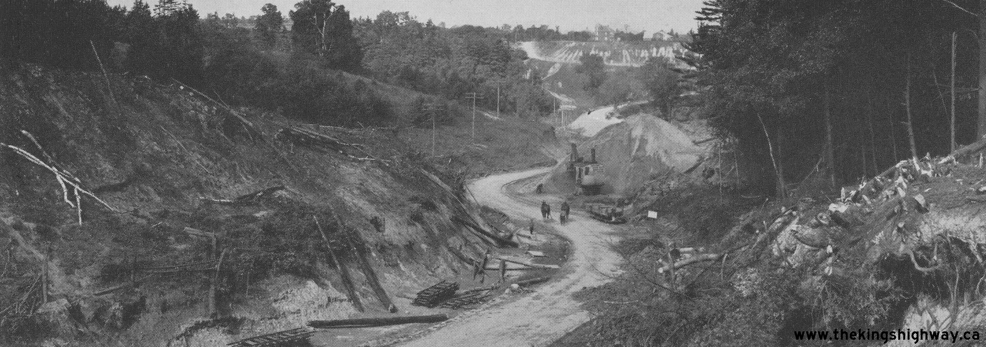
Above - Kingston Road (Hwy 2) at Rouge Hill in Pickering Township in 1919, during road reconstruction. An extensive reconstruction project took place here in
1919-1920, which greatly improved the highway's alignment at this location and included the construction of a new bridge for the Provincial Highway across the Rouge
River. Nearly 1 mile of the Provincial Highway was reconstructed on an improved alignment. See an
Enlarged Photo Here. Photo taken in 1919. (Photo courtesy of Ontario Ministry of Transportation - © King's Printer for Ontario, 1919) 
Above - Completed grading project on the Provincial Highway (Hwy 2) with new engineered drainage ditches in 1919. This photo was taken at an unknown location
along the Kingston Road. Although this may not look like much of a "highway", the resulting road was considerably better than the road which was there before. Prior
to assumption by the DPHO, most of the Provincial Highways were merely winding cart tracks with very poor alignment and narrow earth surfaces, which stretched
haphazardly across the countryside. The lack of drainage ditches along these primitive roads meant that water collected on the road surface, which led to severe
potholes and often impassable stretches of mud during periods of wet weather. See an
Enlarged Photo Here. Photo taken in 1919. (Photo courtesy of Ontario Ministry of Transportation - © King's Printer for Ontario, 1919) 
Above - Widened Hamilton-London Provincial Highway (Hwy 2) between Ancaster and Brantford. See an
Enlarged Photo Here. Photo taken in 1919. (Photo courtesy of Ontario Ministry of Transportation - © King's Printer for Ontario, 1919) 
Above - This diversion of the Provincial Highway (Hwy 2) at a new bridge along the Kingston Road east of Toronto eliminated a sharp curve in the old highway.
See an Enlarged Photo Here. Photo taken in 1920. (Photo courtesy of Ontario Ministry of Transportation - © King's Printer for Ontario, 1920) 
Above - Standard railway crossing sign used by the DPHO on the Toronto-Port Hope Provincial Highway (Hwy 2) in Scarborough Township. See an
Enlarged Photo Here. Photo taken in 1920. (Photo courtesy of Ontario Ministry of Transportation - © King's Printer for Ontario, 1920) 
Above - Crushed gravel surface on the Port Hope-Belleville Provincial Highway (Hwy 2) between Port Hope and Cobourg. See an
Enlarged Photo Here. Photo taken in 1921. (Photo courtesy of Ontario Ministry of Transportation - © King's Printer for Ontario, 1921) 
Above - Crushed gravel surface on the Port Hope-Belleville Provincial Highway (Hwy 2) east of Colborne. See an
Enlarged Photo Here. Photo taken in 1921. (Photo courtesy of Ontario Ministry of Transportation - © King's Printer for Ontario, 1921) 
Above - New concrete culvert and crushed gravel surface on the Hamilton-London Provincial Highway (Hwy 2) near Paris. See an
Enlarged Photo Here. Photo taken in 1921. (Photo courtesy of Ontario Ministry of Transportation - © King's Printer for Ontario, 1921) 
Above - Steam shovel excavating an earth cut for the proposed Toronto, Hamilton & Buffalo (T.H. & B.) Railway Subway at Binkley's Corners near Dundas on
the Hamilton-London Provincial Highway (Hwy 2). The Binkley's Corners Subway was constructed under DPHO Contract #308 and was completed in 1923. See an
Enlarged Photo Here. Photo taken in 1922. (Photo courtesy of Ontario Ministry of Transportation - © King's Printer for Ontario, 1922) 
Above - Water-bound macadam with a bituminous surface treatment on the Kingston-Quebec Boundary Provincial Highway (Hwy 2) along the St. Lawrence River. See an
Enlarged Photo Here. Photo taken in 1922. (Photo courtesy of Ontario Ministry of Transportation - © King's Printer for Ontario, 1922) 
Above - Newly-built concrete pavement on the Hamilton-London Provincial Highway (Hwy 2) west of Crumlin. A 2 1/2-mile section of concrete pavement was
constructed along Hwy 2 between London and Crumlin during 1922, under DPHO Contract #607. See an
Enlarged Photo Here. Photo taken in 1922. (Photo courtesy of Ontario Ministry of Transportation - © King's Printer for Ontario, 1922) 

Left - Early motorists using the new Hamilton Northwest Entrance Highway (later known as Hwy 2 & Hwy 6) between Aldershot and Hamilton in 1923. The
construction of the new highway entrance to Hamilton in the early 1920s included a much shorter route on an improved alignment across a series of high-level viaduct
structures. The new highway entrance allowed motorists arriving in Hamilton via the Toronto-Hamilton Highway (Hwy 2), and the Toronto-Dundas Highway (Hwy 5) to enter
the city with considerable ease and comfort - a major improvement over the winding and treacherous route which motorists previously had to previously endure. The new
Hamilton Northwest Entrance Highway was officially opened to traffic on August 23, 1922. See an
Enlarged Photo Here. Photo taken in 1923. (Photo from Cameron Bevers' historical photograph collection - Original photographer unknown) Right - Side view of the newly-completed Hamilton Entrance Bridge #3 on the Hamilton Northwest Entrance Highway (later known as Hwy 2 & Hwy 6) in 1923. This impressive steel viaduct was constructed under DPHO Contract #141 (structural steel) and DPHO Contract #144 (concrete substructure and approaches) and had a total length of 594 feet. The structure consisted of four steel deck truss spans supported on steel truss pedestals. Although it was not the longest bridge built by the DPHO at the time, it was certainly a very impressive piece of early Provincial Highway infrastructure. Unfortunately, the structure was only designed with a roadway width of 30 feet, which resulted in a traffic bottleneck at the two-lane structure as traffic volumes grew on Hwy 2 & Hwy 6 after World War II. By 1960, this highway bridge was carrying 30,000 vehicles per day, which was exponentially more traffic than the bridge's designers would have originally anticipated. Long-distance through traffic approaching Hamilton from Clappison's Corners and Aldershot had to cross this bridge right up until the completion of the adjacent six-lane Hwy 403 in 1963, after which time traffic volumes on the old highway dropped precipitously. The Hamilton Entrance Bridges were replaced with new concrete structures in the early 1970s under Contract #1972-119. Note the horse-drawn cart using the highway bridge. Although uncommon today, horse-drawn vehicles were frequently seen using Ontario's early highways. They were so common in fact that horse-drawn vehicles were categorized separately during traffic surveys and counts done on King's Highways up until World War II. See an Enlarged Photo Here. Photo taken in 1923. (Photo from Cameron Bevers' historical photograph collection - Original photographer unknown) 
Above - Completed asphaltic concrete surface on the Toronto-Port Hope Provincial Highway (Hwy 2) in Pickering Township. Just over 5 miles of asphaltic
concrete pavement was built along the Kingston Road between Pickering and Whitby during 1923, under DPHO Contract #897. See an
Enlarged Photo Here. Photo taken in 1923. (Photo courtesy of Ontario Ministry of Transportation - © King's Printer for Ontario, 1923) 
Above - View of Hwy 2 between Paris and Brantford in 1925. A hard-surfaced road link was completed between Paris and Brantford in 1923 under DPHO Contract
#794. That year, a new concrete pavement was constructed for a distance of 5.6 miles between these two towns. Prior to this paving contract, Hwy 2 had a gravel
surface between Paris and Brantford. Paving the "Trans-Provincial Highway" became a major priority for the DPHO during the mid-1920s, as Hwy 2 was the province's
main traffic artery at that time. A continuous paved highway link was completed via Hwy 2 between Toronto and London in 1925, when concrete pavement was laid for a
distance of 4 miles west of Paris under DPHO Contract #1164. That contract removed the final gravel section along Hwy 2 between Toronto and London. See an
Enlarged Photo Here. Photo taken in 1925. (Photo courtesy of Ontario Ministry of Transportation - © King's Printer for Ontario, 1925) 
Above - Crew from the Grant Brothers Construction Company laying mixed macadam pavement on Hwy 2 east of Morrisburg, under Contract #1927-23. By the end of
1927, the DPHO had completed paving operations along the entire route of Hwy 2. For the first time, motorists could enjoy uninterrupted travel via Hwy 2 between
Windsor and the Quebec Boundary without a single break in the highway pavement. Paving the roughly 540-mile route of Hwy 2 was a major undertaking by the DPHO, which
took the better part of a decade to complete. However, this construction milestone enshrined Hwy 2 as Ontario's most important highway for many years to come. It
wasn't until the completion of Hwy 401 several decades later that Hwy 2 saw any tangible decrease of its importance in the province's overall transportation network.
See an Enlarged Photo Here. Photo taken in August 1927. (Photo courtesy of Ontario Ministry of Transportation - © King's Printer for Ontario, 2005) 

Left - Warning signs on Hwy 2 approaching the Old Trenton Railway Overhead, located about 4 miles west of Trenton. See an
Enlarged Photo Here. Photo taken in 1929. (Photo courtesy of Ontario Ministry of Transportation - © King's Printer for Ontario, 1929) Right - New Trenton Railway Overhead on Hwy 2 between Brighton and Trenton. This six-span steel pony truss structure was 516 feet in length and crossed the railway lines at a shallow skew of 23 degrees. This impressive new structure was constructed under Contract #1930-25 at a cost of $150,900 (in 1930 Dollars), the equivalent of about $2,575,000 in 2023 Dollars. The new overhead bridge was completed in late 1930 and carried Hwy 2 safely across both the Canadian National Railway (CNR) and Canadian Pacific Railway (CPR) on a significantly-improved alignment. See an Enlarged Photo Here. Photo taken in 1930. (Photo courtesy of Ontario Ministry of Transportation - © King's Printer for Ontario, 1930) 
Above - Improved western approach to the New Trenton Railway Overhead in 1930. This new railway overhead eliminated a narrow timber grade separation on the
original route of Hwy 2, which had a crooked alignment with poor sight lines and very sharp curves at either end. The New Trenton Railway Overhead was one of many
highway improvement projects undertaken by the DPHO along Hwy 2 during the 1920s and early 1930s. In the days prior to the construction of Hwy 401 through this area
in the late 1950s, Hwy 2 was a vital highway corridor which carried most of the province's east-west traffic. See an
Enlarged Photo Here. Photo taken in 1930. (Photo courtesy of Ontario Ministry of Transportation - © King's Printer for Ontario, 1930) 

Left - New mixed macadam pavement constructed along Hwy 2 under Contract #1930-12, about 4 miles east of Cornwall. See an
Enlarged Photo Here. Photo taken in 1930. (Photo courtesy of Ontario Ministry of Transportation - © King's Printer for Ontario, 1930) Right - View of Hwy 2 about 3 miles west of Napanee in 1930. This photo shows the new mixed macadam pavement constructed along Hwy 2 under Contract #1928-17. See an Enlarged Photo Here. Photo taken in 1930. (Photo courtesy of Ontario Ministry of Transportation - © King's Printer for Ontario, 1930) 
Above - Photo of an early King's Highway 2 route marker sign. This photograph was taken somewhere along Hwy 2 in the Summer of 1930, shortly after the
re-designation of Ontario's Provincial Highways as "The King's Highways". This image may be the earliest photograph ever taken of a King's Highway sign out on the
road. King's Highway signs were apparently not common at that time, as this photograph had a handwritten note on the back of it stating that, "This was the right
road and there is only one marker". The handwritten note infers that the majority of the highway was still being signed with the old triangular Provincial Highway
signs at that time. By the end of 1932, more than 9,000 King's Highway route marker signs had been installed along Ontario's Highways. Unfortunately, the exact
location of this photograph and the identity of the gentleman standing next to the highway sign are unknown. See an
Enlarged Photo Here. Photo taken in August 1930. (Photo from Cameron Bevers' historical photograph collection - Original photographer and location unknown) 
Above - Circa 1930 postcard view of the new Moira River Bridge on Bridge Street (Hwy 2 & Hwy 14) in Downtown Belleville. The new bridge officially opened
to traffic on August 4, 1930. See an Enlarged Photo Here. (Photo courtesy of The International Fine Art Company Ltd, Montreal) 
Above - View of Hwy 2 near Odessa in 1930, with new centreline pavement markings implemented. The DPHO began experimenting with pavement markings on macadam
and asphalt-surfaced highways beginning in 1930. Centreline pavement markings on Ontario's highways were white up until the early 1970s, when Ontario switched their
centreline pavement markings over to yellow in keeping with new North American pavement marking standards. See an
Enlarged Photo Here. Photo taken in 1930. (Photo courtesy of Ontario Ministry of Transportation - © King's Printer for Ontario, 1930) 

Left - Whitby Canadian Pacific Railway (CPR) Subway on Hwy 2 in 1930, before the pedestrian underpass was constructed. This narrow railway subway was built in
1913 and had a span width of only 26 feet between the abutment walls. Given the skewed crossing of the railway, the lateral clearance from the edge-of-pavement on
Hwy 2 to the abutment wall face was very minimal. As originally constructed, the railway subway had no provisions for a pedestrian sidewalk, so pedestrians had to
walk on the road. However, as Hwy 2 became progressively busier, a narrow wooden sidewalk was eventually retrofitted alongside the roadway for pedestrians to use. The
sidewalk's alignment was rather crooked through the subway, which was certainly far from ideal. In addition, the sag curve (depressed roadway elevation) along Hwy 2
through the subway meant that the sidewalk sat relatively high when compared to the roadway's elevation. A permanent solution came about in 1931, when a separate
concrete pedestrian tunnel was constructed adjacent to the existing railway grade separation. See an
Enlarged Photo Here. Photo taken in 1930. (Photo courtesy of Ontario Ministry of Transportation - © King's Printer for Ontario, 1930) Right - View of the Whitby CPR Subway and completed concrete pedestrian tunnel on Hwy 2 in 1931. The new pedestrian tunnel allowed the Whitby Subway to accommodate all road users more safely, even as traffic volumes along Hwy 2 continued to grow with increased automobile registration, increased commercial trucking and the proliferation of motor tourism. With the completion of the Toronto-Oshawa Highway (now known as Hwy 401) in 1947, long-distance through traffic no longer had to compete for space through this narrow railway subway. Undoubtedly, the Whitby Subway was a bottleneck that highway engineers were keen to eliminate when the concept of a new superhighway between Toronto and Oshawa was first being proposed in the late 1930s. Both the highway subway and pedestrian tunnel seen in this photo were replaced by a new wider grade separation built under Contract #1965-331. The new structure was completed in 1967 and was designed to fit a widened four-lane cross section for Hwy 2. See an Enlarged Photo Here. Photo taken in 1931. (Photo courtesy of Ontario Ministry of Transportation - © King's Printer for Ontario, 1931) 
Above - Aerial view of the new traffic circle, high-level bridge and park at the Northwest Entrance to Hamilton in 1932. The reconstruction of the Northwest
Entrance to Hamilton resulted in a new route of Hwy 2 through the city. Until 1932, Hwy 2 continued straight into Downtown Hamilton across the high-level bridge
concurrently with Hwy 6. When Longwood Road was extended from Westdale out to this location in the early 1930s, it created a scenic alternate route beside Cootes
Paradise for through traffic to follow, which bypassed Downtown Hamilton altogether. In 1932, Hwy 2 was rerouted onto Longwood Road. A new traffic circle was built at
the junction of Hwy 2 and Hwy 6 in conjunction with the new high-level bridge construction. This traffic circle remained in service for more than 30 years, handling
every vehicle entering or leaving Hamilton on Hwy 2 & Hwy 6. During construction of Hwy 403 between Burlington and Hamilton in 1963, the old Longwood Road
connection to Hwy 6 (at right) was closed off and the traffic circle was subsequently removed. The route of Hwy 2 was then restored to its pre-1932 route via York
Boulevard and Dundurn Street. See an Enlarged Photo Here. Photo taken in 1932. (Photo courtesy of Canadian Airmaps Ltd.) 
Above - Approaching the new bridge over the Desjardins Canal on Longwood Road (Hwy 2) near Cootes Paradise near Hamilton (ca. 1932) (Photo from Cameron Bevers' historical photograph collection - Original photographer unknown) 

Left - Completed Canadian National Railway (CNR) Subway on Hwy 2 in 1932, located between the Grand River Bridge and the Hwy 5 Junction in Paris. This
railway grade separation was constructed by CNR during 1931 as part of a series of highway improvements completed along Hwy 2 at the eastern entrance to Paris during
the early 1930s. See an Enlarged Photo Here. Photo taken in 1932. (Photo courtesy of Ontario Ministry of Transportation - © King's Printer for Ontario, 1932) Right - "Tyton Guard Rail" beside Hwy 2 in Paris, located just west of the Hwy 24A Junction. It is believed that this was the first metal beam roadside barrier system ever installed in Ontario. Up until that time, roadside barrier systems along Southern Ontario's highways usually consisted of a pair of tensioned steel cables or wooden planks which were anchored to cedar posts along the side of the road. See an Enlarged Photo Here. Photo taken in 1933. (Photo courtesy of Ontario Ministry of Transportation - © King's Printer for Ontario, 1933) 
Above - Motorist standing beside a King's Highway 2 sign near Brockville. See an
Enlarged Photo Here. Photo taken on July 7, 1934. (Photo from Cameron Bevers' historical photograph collection - Original photographer unknown)
Continue on to King's Highway 2 Historical Photos from 1935 to 1949
|
|---|
Links to Adjacent King's Highway Photograph Pages:
Back to Tertiary Highway 812 Photos /
King's Highway 2 History /
On to King's Highway 3 Photos
Ontario Highway History - Main Menu / Back to List of Highways Website contents, photos & text © 2002-2026, Cameron
Bevers (Webmaster) - All Rights Reserved / Contact Me
|
|---|