
| 
| |
|
|
This page contains historical photos of Ontario's King's Highway 2 dating from 1950 to 1959. All photographs displayed on
this page were taken by the Ontario Ministry of Transportation, unless specifically noted otherwise. Historical photographs are arranged in approximate chronological
order. Click on any thumbnail to see a larger image!
Please note that all photographs displayed on this
website are protected by copyright. These photographs must not be reproduced, published,
electronically stored or copied, distributed, or posted onto other websites without
my written permission. If you want to use photos from this website, please
email me first for permission. Thank-you!
|
|---|
|
Page 3: Historical King's Highway 2 Photographs (1950 to 1959)


Left - Thames River Bridge on Fifth Street (Hwy 2) in Downtown Chatham. See an
Enlarged Photo Here. Photo taken circa 1950. (Photo courtesy of Ontario Department of Travel and Publicity - © King's Printer for Ontario, 1950) Right - Old Roosevelt International Bridge between Hwy 2 in Cornwall and New York State. This structure carried both road and rail traffic at the time this photo was taken. Before the Ogdensburg-Prescott International Bridge opened to traffic in 1960, this was the only other highway bridge across the St. Lawrence River between Ontario and the United States east of the Thousand Islands-Ivy Lea Bridge near Gananoque. See an Enlarged Photo Here. Photo taken circa 1950. (Photo courtesy of Ontario Department of Travel and Publicity - © King's Printer for Ontario, 1950) 
Above - Circa 1950 postcard view of Hwy 2 at the municipal welcome arch at the western entrance to Gananoque. See an
Enlarged Photo Here. Photo taken circa 1950. (Photo courtesy of the Photogelatine Engraving Company Ltd, Toronto) 
Above - View of a reconstructed section of Hwy 2, located about 3 1/2 miles west of Trenton. Under Contract #1950-50, Hwy 2 was resurfaced with hot-mix asphalt
pavement for a distance of nearly 17 miles between Trenton and Colborne, along with some vertical profile corrections such as this one. See an
Enlarged Photo Here. Photo taken on June 13, 1950. (Photo courtesy of Ontario Ministry of Transportation - © King's Printer for Ontario, 1950) 

Left - Overlaying concrete pavement with hot-mix asphalt on Hwy 2, about 4 1/2 miles east of Windsor, Contract #1950-31. See an
Enlarged Photo Here. Photo taken on July 5, 1950. (Photo courtesy of Ontario Ministry of Transportation - © King's Printer for Ontario, 1950) Right - Completed hot-mix asphalt resurfacing and zone striping on Hwy 2, 12 1/2 miles east of Windsor. Under Contract #1949-05, about 12 miles of resurfacing took place along Hwy 2 in the vicinity of St. Joachim. Some of the existing concrete pavement along Hwy 2 in this area was laid a long time ago and was thus built to the old standard pavement width of 20 feet. Under this contract, the pavement width was expanded out to the standard width of the day, which was 22 feet. See an Enlarged Photo Here. Photo taken on July 5, 1950. (Photo courtesy of Ontario Ministry of Transportation - © King's Printer for Ontario, 1950) 

Left - View of both the old and new bridges over the Salmon River on Hwy 2 in Napanee in 1951. A new two-lane concrete structure was built in 1950 in order to
bypass the old one-lane bridge at left. Not only did this bridge replacement project eliminate a traffic bottleneck at the narrow bridge, it also removed an abrupt
highway curve. See an Enlarged Photo Here. Photo taken on March 27, 1951. (Photo courtesy of Ontario Ministry of Transportation - © King's Printer for Ontario, 1951) Right - Another view of the new concrete bridge over the Salmon River on Hwy 2 in Napanee, completed under Contract #1950-29. See an Enlarged Photo Here. Photo taken on March 27, 1951. (Photo courtesy of Ontario Ministry of Transportation - © King's Printer for Ontario, 1951) 
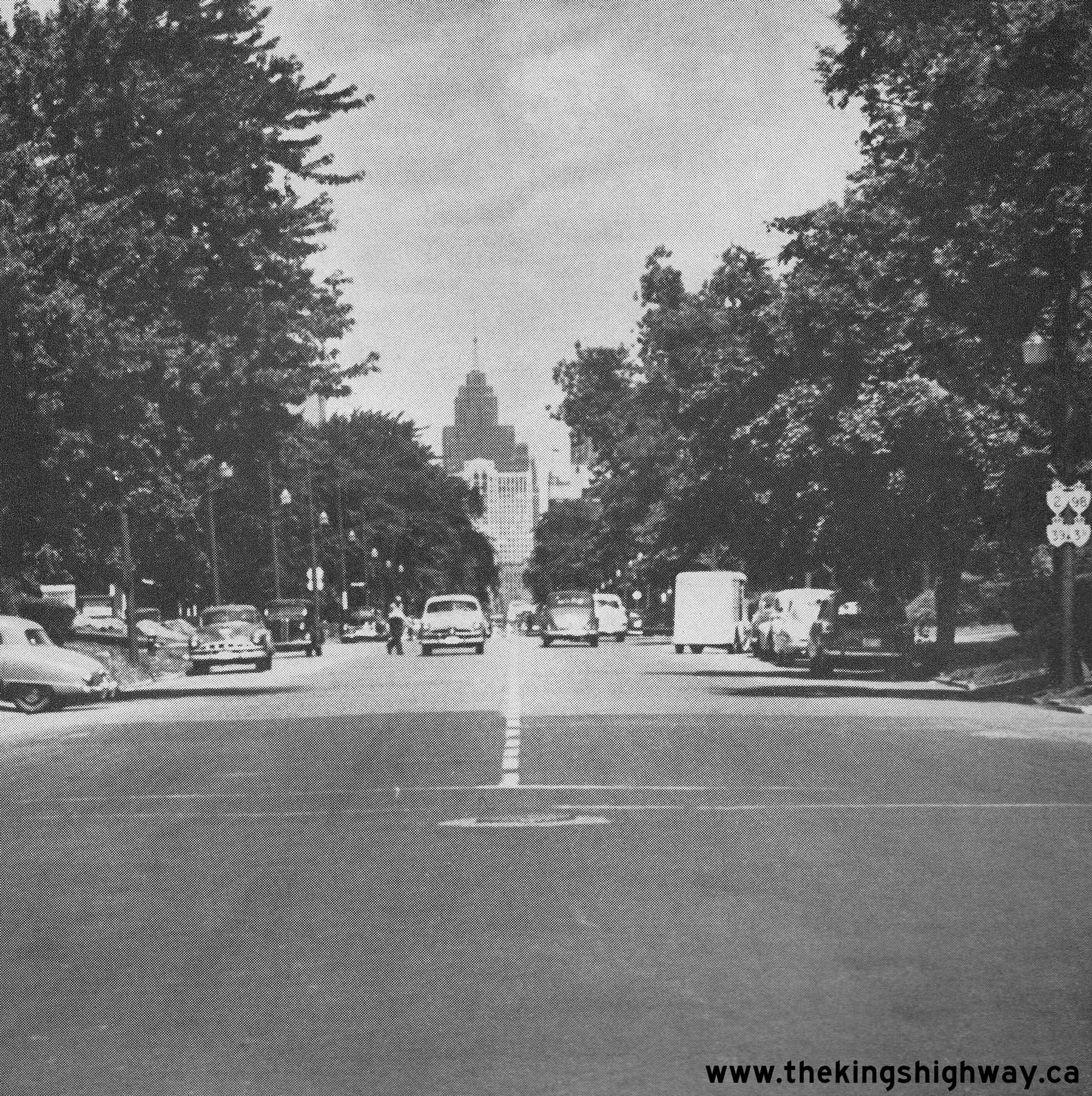
Above - View of Dundas Street (Hwy 2) in Downtown London, facing west towards the Hwy 4 & Hwy 22 Junction at Clarence Street. See an
Enlarged Photo Here. Photo taken in 1951. (Photo courtesy of Ontario Department of Travel and Publicity - © King's Printer for Ontario, 1951) 

Left - Resurfaced section of Hwy 2 along the St. Lawrence River west of Prescott, Contract #1949-390. See an
Enlarged Photo Here. Photo taken on May 8, 1951. (Photo courtesy of Ontario Ministry of Transportation - © King's Printer for Ontario, 1951) Right - Facing north along Ouellette Avenue towards Downtown Windsor in 1951. Note the signpost at right, which bears no fewer than four King's Highway shields. Although the route numbers are difficult to discern in this photo, the four marked routes are Hwy 2, Hwy 3B, Hwy 39 and Hwy 98. For a number of years, all four of these King's Highways were signed concurrently along Ouellette Avenue into Downtown Windsor. However, due to the construction of the E.C. Row Expressway and the decommissioning of Hwy 39 and Hwy 98, three of these highway routes were eventually removed from Ouellette Avenue. Only the Hwy 3B route designation survived until the 1990s. See an Enlarged Photo Here. Photo taken on July 10, 1951. (Photo courtesy of Ontario Ministry of Transportation - © King's Printer for Ontario, 1951) 

Left - New hot-mix asphalt pavement and zone painting along Hwy 2, about 1 mile west of Princeton. Most sections of Hwy 2 between Paris and the Hwy 53 Junction
at Eastwood were resurfaced under Contract #1950-405. See an Enlarged Photo Here. Photo taken on
July 13, 1951. (Photo courtesy of Ontario Ministry of Transportation - © King's Printer for Ontario, 1951) Right - New Hwy 2 diversion located about 3 miles east of Colborne, completed under Contract #1950-50. See an Enlarged Photo Here. Photo taken on October 9, 1951. (Photo courtesy of Ontario Ministry of Transportation - © King's Printer for Ontario, 1951) 

Left - Zone painting on Hwy 2, about 8 miles west of Port Hope. Note an early installation of a diamond-shaped curve and intersection warning sign beside
Hwy 2 in the background. Most warning signs used on Ontario's highways prior to the 1950s were square-shaped and were white-and-black in colour. As part of a
universal effort to standardize traffic sign installations across all North American jurisdictions during the 1950s, the Department of Highways of Ontario (DHO)
adopted new yellow-and-black coloured diamond-shaped warning signs, as specified in the Manual of Uniform Traffic Control Devices (MUTCD). By 1960, the old
white-and-black coloured square-shaped warning signs had been phased out and switched over to the new MUTCD standard yellow-and-black coloured diamond-shaped warning
signs, which are still in use today. See an Enlarged Photo Here. Photo taken on October 9,
1951. (Photo courtesy of Ontario Ministry of Transportation - © King's Printer for Ontario, 1951) Right - Eastern Steel Salt Spreader at work on Hwy 2 (Kingston Road) near the Rouge River. See an Enlarged Photo Here. Photo taken on December 5, 1951. (Photo courtesy of Ontario Ministry of Transportation - © King's Printer for Ontario, 1951) 

Left - Exterior view of the new DHO District #2 (London District) Garage located on Hwy 2 west of Lambeth. See an
Enlarged Photo Here. Photo taken on June 6, 1952. (Photo courtesy of Ontario Ministry of Transportation - © King's Printer for Ontario, 1952) Right - Winter snow-clearing equipment at the Lambeth DHO Garage on Hwy 2. See an Enlarged Photo Here. Photo taken on June 6, 1952. (Photo courtesy of Ontario Ministry of Transportation - © King's Printer for Ontario, 1952) 

Left - Interior view of the DHO Garage west of Lambeth on Hwy 2. See an
Enlarged Photo Here. Photo taken on June 6, 1952. (Photo courtesy of Ontario Ministry of Transportation - © King's Printer for Ontario, 1952) Right - Department of Highways' Sign Truck at the District #7 (Port Hope District) Garage. See an Enlarged Photo Here. Photo taken on July 17, 1952. (Photo courtesy of Ontario Ministry of Transportation - © King's Printer for Ontario, 1952) 

Left - Aerial view of Plains Road (Hwy 2) at the newly-built Mausoleum Curve located between Hamilton and Aldershot. Constructed in 1950 under Contract
#1950-57, this new sweeping highway curve offered an improved horizontal road alignment and an expanded four-lane concrete pavement. The previous curve at the
mausoleum at left was built in the early 1920s. The old curve on Hwy 2 had a very tight radius and was only two lanes, so it was bypassed altogether by an improved
highway on an entirely new alignment. Although the DHO had plans to widen and improve the Mausoleum Curve as early as 1941, the project had to be deferred due to
dwindling supplies of construction materials and unavailability of personnel and construction equipment as a result of World War II. See an
Enlarged Photo Here. Photo taken in 1952. (Photo courtesy of Ontario Ministry of Transportation - © King's Printer for Ontario, 1952) Right - View of the Tecumseh DHO Roadside Park located on Hwy 2, about 2 1/2 miles east of Thamesville. See an Enlarged Photo Here. Photo taken on October 1, 1953. (Photo courtesy of Ontario Ministry of Transportation - © King's Printer for Ontario, 1953) 

Left - Paving operations on Hwy 2 by McNamara Construction under Contract #1953-429, about 2 miles east of Dickenson's Landing in 1954. This photo and the one
at right show sections of the original route of Hwy 2, which were flooded in the late 1950s as a result of the St. Lawrence Seaway's construction. Between 1954 and
1957, approximately 37 miles of Hwy 2 had to be relocated inland onto higher ground to bypass those parts of the valley which lay below the proposed Seaway flood
line. The section of Hwy 2 shown here in this 1954 photo is now submerged under the St. Lawrence River near Moulinette Island south of Long Sault. See an
Enlarged Photo Here. Photo taken on July 20, 1954. (Photo courtesy of Ontario Ministry of Transportation - © King's Printer for Ontario, 1954) Right - Newly-resurfaced section of Hwy 2, about 1 mile west of Farran's Point in 1954. About 16 miles of highway resurfacing took place along Hwy 2 west of Cornwall during 1953 and 1954, under Contract #1953-429. This section of Hwy 2 was flooded four years after this photo was taken, due to the construction of the St. Lawrence Seaway. This section of the highway now lies submerged under the St. Lawrence River near Morrison Island southwest of Ingleside. See an Enlarged Photo Here. Photo taken on July 20, 1954. (Photo courtesy of Ontario Ministry of Transportation - © King's Printer for Ontario, 1954) 
Above - Resurfaced section of Hwy 2, about 6 1/2 miles west of Odessa. Resurfacing was carried out between Odessa and Napanee under Contract #1953-399 for a
distance of about 12 3/4 miles during 1953 and 1954. See an Enlarged Photo Here. Photo taken on
July 23, 1954. (Photo courtesy of Ontario Ministry of Transportation - © King's Printer for Ontario, 1954) 
Above - Resurfaced entrance to the Eastwood Truck Scales and Scale House on Hwy 2 near Woodstock, constructed by Day Labour. See an
Enlarged Photo Here. Photo taken on August 17, 1954. (Photo courtesy of Ontario Ministry of Transportation - © King's Printer for Ontario, 1954) 
Above - Circa 1955 postcard view of Hwy 2 along the St. Lawrence River between Brockville and Cornwall. See an
Enlarged Photo Here. Photo taken circa 1955. (Photo courtesy of Ran-Gal Studios, Cornwall) 
Above - New Parry Bridge over the Thames River on Keil Drive in Chatham in 1955. This municipal road project proved to be so effective in diverting through
traffic around Downtown Chatham, that the DHO eventually incorporated Keil Drive and the Parry Bridge into the route of a Hwy 2 Bypass around Chatham in 1957. See an
Enlarged Photo Here. Photo taken on July 6, 1955. (Photo courtesy of Ontario Ministry of Transportation - © King's Printer for Ontario, 1955) 

Left - Facing south along Hwy 2 & Hwy 6 (York Boulevard) at the Hamilton Northwest Entrance Bridge #3. This high-level structure was situated between
Hamilton and Aldershot. Prior to the construction of Hwy 403 in the 1960s, all traffic approaching Downtown Hamilton from Toronto and Burlington passed across this
bridge. The two-lane structure seen here was replaced in the 1970s with a new four-lane structure. See an
Enlarged Photo Here. Photo taken on July 16, 1955. (Photo courtesy of Ontario Ministry of Transportation - © King's Printer for Ontario, 2022) Right - Hamilton Northwest Entrance Bridge #3 on Hwy 2 & Hwy 6 (York Boulevard), facing north towards Aldershot. This large steel deck truss structure was originally constructed by the Department of Public Highways of Ontario (DPHO) in 1922. See an Enlarged Photo Here. Photo taken on July 16, 1955. (Photo courtesy of Ontario Ministry of Transportation - © King's Printer for Ontario, 2022) 
Above - Circa 1955 view of the Long Sault Rapids along the St. Lawrence River west of Cornwall. This section of Hwy 2 was situated on a hill high above
Historic Lock #21 on the Cornwall Canal. When the St. Lawrence Valley was flooded in 1958 as part of the St. Lawrence Seaway's construction, the Long Sault Rapids and
the Cornwall Canal Lock were both consumed by the floodwaters. However, the section of Hwy 2 seen in this photo sat mostly above the flood line in this area and was
thus spared from inundation. This bypassed highway now serves as a park access road on Macdonnell Island. See an
Enlarged Photo Here. Photo taken circa 1955. (Photo © Archives of Ontario - Series RG-65-35, Photo #I-0014680) 

Left - Resurfaced four-lane section of Hwy 2 at Aldershot between Hamilton and Burlington, Contract #1955-351. See an
Enlarged Photo Here. Photo taken on November 28, 1955. (Photo courtesy of Ontario Ministry of Transportation - © King's Printer for Ontario, 1955) Right - Facing east along Hwy 2 & Hwy 33 (Dundas Street) approaching Downtown Trenton. See an Enlarged Photo Here. Photo taken on June 28, 1956. (Photo courtesy of Ontario Ministry of Transportation - © King's Printer for Ontario, 1956) 
Above - Aerial view of Hwy 401 in 1956 facing west from the Lansing Road Interchange (today's Port Union Road) in Scarborough. This photo shows the start of
the Toronto Bypass in the background and the old bypassed portion of Hwy 2A leading to Hwy 2 (Kingston Road). Compare this view of the highway in 1956, with this
recent aerial photo showing the area as it appears today. Photo taken in 1956. (Photo courtesy of Ontario Ministry of Transportation - © King's Printer for Ontario, 1956) 
Above - Channelized right turn ramps at the junction of Old Hwy 2 and Relocated Hwy 2 in Cornwall in 1956, built under Contract #1954-112. This interesting
view shows Brookdale Avenue (Relocated Hwy 2) facing south towards Second Avenue (Old Hwy 2), just before the construction of the Seaway International Bridge began at
right. See an Enlarged Photo Here. Photo taken on August 8, 1956. (Photo courtesy of Ontario Ministry of Transportation - © King's Printer for Ontario, 1956) 
Above - Zone striping on a section of Relocated Hwy 2, four miles west of Cornwall in 1956. Approximately 37 miles of Hwy 2 had to be relocated onto a new
alignment in the late 1950s to accommodate the construction of the St. Lawrence Seaway. Most of the original Hwy 2 alignment between Iroquois and Cornwall lay below
the proposed Seaway flood line and was closed to through traffic before the valley was flooded in 1958. The first phase of the Hwy 2 relocation took place under
Contract #1954-112 from Cornwall westerly for a distance of 7 1/2 miles. This section of the relocated highway was completed in 1955. See an
Enlarged Photo Here. Photo taken on August 8, 1956. (Photo courtesy of Ontario Ministry of Transportation - © King's Printer for Ontario, 1956) 
Above - View of the Credit River Bridge on Lakeshore Road (Hwy 2), as seen from the Port Credit Yacht Club. See an
Enlarged Photo Here. Photo taken in 1957. (Photo © Archives of Ontario - Series RG-65-35, Photo #I-0005570) 
Above - Newly-installed overhead guide signs on westbound Hwy 401 approaching the Lansing Road (now Port Union Road) Interchange in Scarborough in 1957. These
overhead signs were installed only moments before this photo was taken. In fact, the DHO's sign truck can be seen parked on the shoulder just a short distance up the
highway. As Ontario's freeway interchanges became progressively more complex in the 1950s, the DHO made increasing use of overhead signs to provide positive guidance
to motorists approaching major decision points such as this. This photo is also rather noteworthy in that it was the very first highway photo published on the front
cover of the Department's long-running monthly employee newsletter "DHO News" in May 1957. See an
Enlarged Photo Here. Photo taken on April 10, 1957. (Photo courtesy of Ontario Ministry of Transportation - © King's Printer for Ontario, 1957) 

Left - Overhead signs marking Hwy 2 and Hwy 401 (the Toronto Bypass) at the Hwy 2A & Hwy 401 Interchange in Scarborough in 1957. This interesting photo
shows some of Ontario's earliest overhead freeway junction signs. Although these overhead guide signs may seem relatively simple when compared to our freeway signs
today, these early experiments in overhead guide sign installation ultimately led to the development of the freeway sign standards that are in use today. The
westbound "exit" of Hwy 401 to the Toronto Bypass (which was a newer extension of Hwy 401) was particularly counterintuitive to motorists. Heading westbound, the
apparent "through highway" at this interchange was actually an exit from Hwy 401 onto a different route (Hwy 2A). These overhead guide signs helped to convey the
message that by continuing straight ahead, motorists would end up on Kingston Road (Hwy 2) and that one had to keep right at the fork to stay on Hwy 401. See an
Enlarged Photo Here. Photo taken on May 13, 1957. (Photo courtesy of Ontario Ministry of Transportation - © King's Printer for Ontario, 1957) Right - Eastern terminus of the Toronto Bypass (Hwy 401) at Hwy 2A in Scarborough, facing west near the Lansing Road Interchange (today's Port Union Road). When the new Toronto Bypass section of Hwy 401 was built in the mid-1950s, it left behind a short 2-mile section of the original Toronto-Oshawa Highway (Hwy 2A). When it was first completed in 1947, the Toronto-Oshawa Highway (Hwy 2A) continued straight ahead to join Hwy 2 (Kingston Road) at West Hill. During the early 1970s, this confusing interchange was reconfigured so that Hwy 401 became the "through highway" at the interchange and Hwy 2A became the exiting highway. The old interchange configuration seen here likely caught many early Hwy 401 motorists by surprise heading westbound, when they discovered (most likely too late) that they were supposed to keep right at the fork to stay on Hwy 401. Although the new overhead signing helped, the revised interchange at Hwy 2A & Hwy 401 built in the 1970s was more in keeping with motorists' expectations. See an Enlarged Photo Here. Photo taken on May 13, 1957. (Photo courtesy of Ontario Ministry of Transportation - © King's Printer for Ontario, 1957) 
Above - Highways Minister James N. Allan and Woodstock Mayor C.M. Tatham shake hands after using an axe to chop down a "Road Closed to Traffic" sign at the
Hwy 2 Cloverleaf at the eastern entrance to the London-Woodstock Bypass section of Hwy 401. Official opening ceremonies were held in both Woodstock and London on
Friday, May 31, 1957, to mark the completion of a 38-mile section of Hwy 401 between Hwy 2 and Hwy 4. This section of Hwy 401 took 5 years to construct at a cost (in
1957 Dollars) of $19.7 million, the equivalent of roughly $208 million in 2023 Dollars. See an
Enlarged Photo Here. Photo taken on May 31, 1957. (Photo courtesy of Ontario Ministry of Transportation - © King's Printer for Ontario, 1957) 
Above - Facing west across the Soper Creek Bridge on Hwy 2, located just east of Bowanville. See an
Enlarged Photo Here. Photo taken on August 21, 1957. (Photo courtesy of Ontario Ministry of Transportation - © King's Printer for Ontario, 2023) 

Left - Circa 1957 postcard view of King Street (Hwy 2) in Downtown Brockville, facing east from Buell Street. This photo shows King Street at a time when all
long-distance through traffic between Kingston and Montreal passed through the city centre. A new section of Hwy 401 (the Brockville Bypass) was completed around the
city in 1959, which allowed through traffic to bypass the city centre altogether. See an
Enlarged Photo Here. Photo taken circa 1957. (Photo courtesy of L.F. Charter) Right - Circa 1958 postcard view of King Street (Hwy 2) facing east from Stone Street (Hwy 32) in Downtown Gananoque. See an Enlarged Photo Here. Photo taken circa 1958. (Photo courtesy of The Gananoque Reporter, Gananoque) 
Above - Facing west along Relocated Hwy 2 approaching the Hwy 31 Junction in Morrisburg, Contract #1957-125. The Town of Morrisburg had to be partially
relocated during the 1950s, as portions of the town including its Main Street lay below the proposed St. Lawrence Seaway's flood line. Morrisburg's new "downtown" was
situated in a series of shopping plazas located adjacent to the Hwy 2 & Hwy 31 Junction. See an
Enlarged Photo Here. Photo taken in 1958. (Photo courtesy of Ontario Ministry of Transportation - © King's Printer for Ontario, 1958) 
Above - Relocated section of Hwy 2, about 1 mile east of Morrisburg, Contract #1957-125. This view shows the final section of Hwy 2 to be relocated above the
proposed St. Lawrence Seaway's flood line. This relocated route of Hwy 2 was completed with a granular surface in November 1957 and paved in the Spring of 1958 - just
in time before the old route of Hwy 2 disappeared forever below the Seaway's floodwaters on "Inundation Day", July 1, 1958. Considering that they only had 4 years to
prepare for the proposed Seaway's arrival, it was a truly remarkable feat by planners, engineers and contractors to successfully plan out the logistics and construct
all of the required relocations of highways, railways, canals, utilities and even entire towns within such a condensed period prior to Inundation Day. See an
Enlarged Photo Here. Photo taken in 1958. (Photo courtesy of Ontario Ministry of Transportation - © King's Printer for Ontario, 1958) 
Above - Junction of Hwy 2 & Hwy 401 (Thousand Islands Parkway) near Brockville in 1958, facing west towards Gananoque. For many years, these two highways
joined together at a skewed at-grade intersection. A new bridge and interchange was built near here as part of the new Brockville Bypass section of Hwy 401 in 1959.
See an Enlarged Photo Here. Photo taken on August 8, 1958. (Photo © Archives of Ontario - Series RG-14-151-5-15, Photo #999) 
Above - Deputy Minister of Highways W.J. Fulton delivering an address at the official opening of the Chatham Bypass (Hwy 2) on August 25, 1958. This multi-year
construction project included the widening of Grand Avenue to four lanes along with the construction of a new western bypass of Chatham (Keil Drive) via the Parry
Bridge under a municipal roads project. Traffic had been able to use the new road around Chatham's City Centre ever since the Parry Bridge was completed, but the
bypass was not officially opened to traffic under all construction had ceased in 1958. See an
Enlarged Photo Here. Photo taken on August 25, 1958. (Photo courtesy of Ontario Ministry of Transportation - © King's Printer for Ontario, 1958) 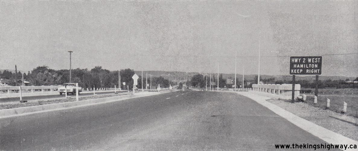
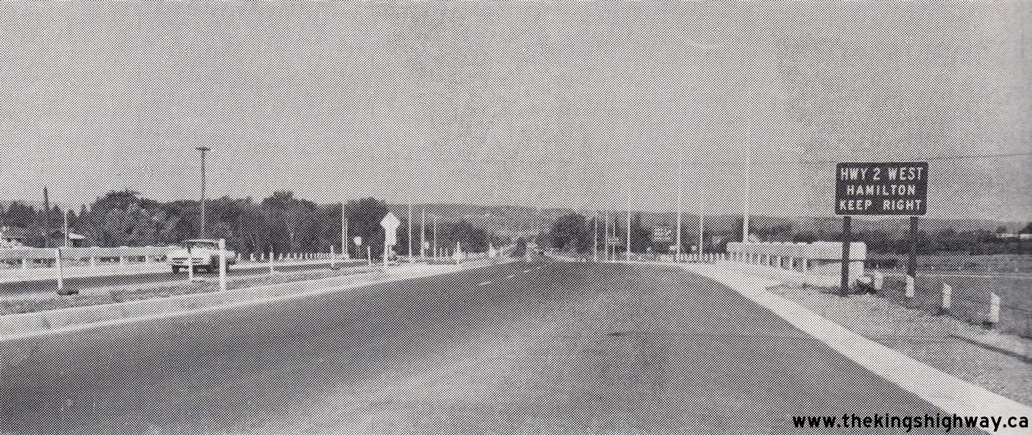
Above - Facing north along the Queen Elizabeth Way at the new Hwy 2 (North Shore Boulevard) Interchange in Burlington in 1958. Prior to the completion of the
underpass and interchange, Hwy 2 crossed the Queen Elizabeth Way at an at-grade intersection. Note the small plywood guide sign at right, advising motorists of the
upcoming Hwy 2 West exit ramp. In an effort to improve on sign legibility on Ontario's freeways, small plywood guide signs such as this example were phased out and
replaced with ground-mounted extruded aluminum signs in the late 1960s and early 1970s. See an
Enlarged Photo Here. Photo taken on September 5, 1958. (Photo courtesy of Ontario Ministry of Transportation - © King's Printer for Ontario, 1958) 

Left - Facing east towards Downtown Toronto along the newly-completed Gardiner Expressway from Sunnyside Beach in 1958. This photo shows the first completed
section of the Gardiner Expressway about 2 months after it was officially opened to traffic between the Humber River and Jameson Avenue on August 8, 1958. The new
six-lane expressway was built to relieve traffic congestion on adjacent Lakeshore Boulevard (Hwy 2) at right, which served as the main western traffic artery into
Downtown Toronto prior to the expressway's construction. Throughout the 1960s, the Gardiner Expressway was extended easterly from Jameson Avenue through Downtown
Toronto to Leslie Street, mostly via an elevated highway structure. The expressway itself was built by Metropolitan Toronto, although the earlier phases of the
expressway's construction was funded partially by the Province of Ontario under a municipal roads cost-sharing program. Although the Gardiner Expressway was signed as
Hwy 2 by Metropolitan Toronto, it was never in fact designated as a provincial highway. Jurisdiction, ownership and all administration activities related to the
expressway have always been managed within the City of Toronto. On November 27, 2023, the Premier of Ontario announced the "upload" of the Gardiner Expressway and the
Don Valley Parkway from the city to the province, but there have been few details released yet about what the province's involvement will actually be in terms of
administration, moving forward. Whether either of these municipal expressways become designated links in the provincial highway system still remains to be seen, and
will certainly be the subject of further discussion between both levels of government in the months ahead and studied under a third-party review. See an
Enlarged Photo Here. Photo taken on October 3, 1958. (Photo courtesy of Ontario Ministry of Transportation - © King's Printer for Ontario, 1958) Right - Circa 1958 view of Downtown Toronto from the intersection of York Street (Hwy 11A) and Fleet Street (Hwy 2). This view of Downtown Toronto is quite the contrast to today's skyline. This photo was taken at a time when the Royal York Hotel (across from Union Station in the foreground) and Canadian Bank of Commerce Building (background) were the tallest structures of the city's skyline. The Canadian Bank of Commerce building was Canada's tallest skyscraper when it was first opened in 1932 - a record which went unbroken for more than 3 decades. Noticeably absent in this photo is the elevated portion of the Gardiner Expressway, which wasn't built until the 1960s. Today, the Toronto skyline is filled with skyscrapers - a testament to Toronto's undisputed economic success and progress over the past century. See an Enlarged Photo Here. Photo taken circa 1958. (Photo © Archives of Ontario - Series RG-65-35, Photo #I-0015001) 
Above - Facing east towards Downtown Toronto along the newly-completed Gardiner Expressway approaching the Canadian National Exhibition (CNE) grounds in 1958.
This interesting photo shows the first completed section of the Gardiner Expressway at Jameson Avenue in a staged condition, where traffic was already using the
westbound lanes of the new expressway from a temporary on-ramp from westbound Lakeshore Boulevard (Hwy 2). The eastbound lanes of the expressway were not yet open to
traffic, as eastbound motorists were forced off of the expressway at the nearby Jameson Avenue exit ramp and onto Lakeshore Boulevard. The temporary westbound on-ramp
to the Gardiner Expressway was closed and relocated further west after this photo was taken. See an
Enlarged Photo Here. Photo taken in 1958. (Photo courtesy of Ontario Ministry of Transportation - © King's Printer for Ontario, 1958) 
Above - Circa 1958 postcard view showing an aerial view of the construction of the Gardiner Expressway (Hwy 2) in Toronto at Jameson Avenue. At the time this
photo was taken, the Gardiner Expressway was only completed between the end of the Queen Elizabeth Way at the Humber River and the Jameson Avenue Overpass. All
traffic was forced off the expressway at this point, where motorists had to continue into Downtown Toronto via Lakeshore Boulevard. See an
Enlarged Photo Here. Photo taken circa 1958. (Photo courtesy of Metro Toronto News Company, Scarborough) 
Above - Replacement of the Port Credit Bridge on Hwy 2 in 1959. The original concrete bowstring arch bridge at right was constructed by the Toronto and
Hamilton Highway Commission in 1918, years before the Lakeshore Road was designated as part of King's Highway 2. During the bridge reconstruction project, Hwy 2
traffic was diverted over the Credit River across temporary Bailey Bridges. See an
Enlarged Photo Here. Photo taken on June 2, 1959. (Photo courtesy of Ontario Ministry of Transportation - © King's Printer for Ontario, 1959) 
Above - Triple Bailey Bridge installation over the Credit River on Lakeshore Road (Hwy 2) in Port Credit in 1959. Three Bailey Bridges were deployed to the
Credit River site by the DHO - one bridge each carried eastbound and westbound traffic on Hwy 2, while a third bridge was deployed to carry a pedestrian sidewalk as
well as relocated municipal utilities. These Bailey Bridges were actually "on loan" from DHO to the County of Peel. The Credit River Bridge had been under the
administration of Peel County since the 1920s. Accordingly, the bridge replacement was carried out under a municipal contract, with assistance from DHO. See an
Enlarged Photo Here. Photo taken on June 2, 1959. (Photo courtesy of Ontario Ministry of Transportation - © King's Printer for Ontario, 1959) 
Above - Construction of the new Thames River Bridge on Hwy 2 at Delaware, Contracts #1958-213 (structural steel) and #1958-266 (concrete substructure and
approaches). See an Enlarged Photo Here. Photo taken on October 21, 1959. (Photo courtesy of Ontario Ministry of Transportation - © King's Printer for Ontario, 1959) 
Above - The new and the old: A new wider bridge for Hwy 2 traffic begins to take form adjacent to the old single-lane bridge over the Thames River at Delaware,
Contract #1958-266. Although Southern Ontario had numerous single-lane bridges such as this one along the King's Highways, there were relatively few situated on Hwy 2,
as it was Ontario's main traffic artery before the construction of Hwy 401 in the 1950s and 1960s. By the late 1950s, this single-lane bridge was carrying over 6,000
vehicles per day. Accordingly, the replacement of the Delaware Bridge in 1959 eliminated one of Southwestern Ontario's greatest traffic bottlenecks. The new Thames
River Bridge on Hwy 2 at Delaware was officially opened to traffic on November 19, 1959. The old bridge at right was demolished after the new bridge opened to
traffic. See an Enlarged Photo Here. Photo taken on October 21, 1959. (Photo courtesy of Ontario Ministry of Transportation - © King's Printer for Ontario, 1959)
Continue on to King's Highway 2 Historical Photos from 1960 to 1974
|
|---|
Links to Adjacent King's Highway Photograph Pages:
Back to Hwy 2 - Historical Photos (1935-1949)
Hwy 2 Photo Index
On to Hwy 2 - Historical Photos (1960-1974)
Back to Tertiary Highway 812 Photos /
King's Highway 2 History /
On to King's Highway 3 Photos
Ontario Highway History - Main Menu / Back to List of Highways Website contents, photos & text © 2002-2026, Cameron
Bevers (Webmaster) - All Rights Reserved / Contact Me
|
|---|