
| 
| |
|
|
This page contains historical photos of Ontario's King's Highway 33 dating from 1930 to 1999. All photographs displayed on
this page were taken by the Ontario Ministry of Transportation, unless specifically noted otherwise. Historical photographs are arranged in approximate chronological
order. Click on any thumbnail to see a larger image!
Please note that all photographs displayed on this
website are protected by copyright. These photographs must not be reproduced, published,
electronically stored or copied, distributed, or posted onto other websites without
my written permission. If you want to use photos from this website, please
email me first for permission. Thank-you!
|
|---|
|
Page 1: Historical King's Highway 33 Photographs (1930 to 1999)

Above - New bituminous penetration pavement on Hwy 33 north of Glen Miller (1935) (Photo courtesy of Ontario Ministry of Transportation - © King's Printer for Ontario, 1935) 

Left - New bituminous penetration pavement on Hwy 33 between Trenton and Frankford, facing north (1935) (Photo courtesy of Ontario Ministry of Transportation - © King's Printer for Ontario, 1935) Right - New swing bridge over the Murray Canal at Carrying Place (1936) (Photo courtesy of Ontario Ministry of Transportation - © King's Printer for Ontario, 1936) 
Above - Panoramic view of the completed Kingston Traffic Circle at the Hwy 2 & Hwy 33 Junction in 1942. This interesting traffic circle was one of the only
intersections of this type ever built along the King's Highways in Eastern Ontario. The Kingston Traffic Circle was built under Contract #1941-30. It replaced a
skewed intersection between Hwy 2 (Princess Street) and Hwy 33 (Bath Road). This traffic circle remained in service up until the 1970s, when it was replaced with a
realigned intersection controlled by traffic signals. See an Enlarged Photo Here. Photo taken in
1942. (Photo courtesy of Ontario Ministry of Transportation - © King's Printer for Ontario, 1942) 

Left - View of Hwy 33 one mile east of Picton. Photo taken on June 11, 1947. See an
Enlarged Photo Here. (Photo courtesy of Ontario Ministry of Transportation - © King's Printer for Ontario, 1947) Right - View of Hwy 33 three miles west of Bath in 1949. See an Enlarged Photo Here. (Photo courtesy of Ontario Ministry of Transportation - © King's Printer for Ontario, 1949) 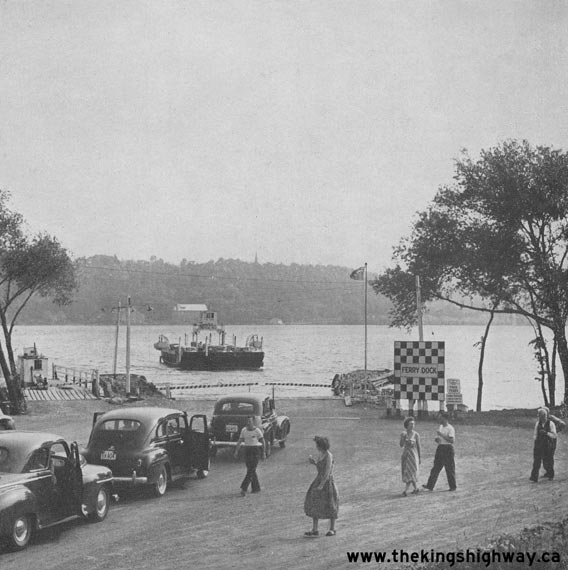
Above - Traffic waiting at the Adolphustown Ferry Dock on Hwy 33 at the Bay of Quinte in 1951. See an
Enlarged Photo Here. (Photo courtesy of Ontario Ministry of Transportation - © King's Printer for Ontario, 1951) 
Above - View of Hwy 33, 2 miles north of Consecon. Photo taken on October 5, 1951. See an
Enlarged Photo Here. (Photo courtesy of Ontario Ministry of Transportation - © King's Printer for Ontario, 1951) 
Above - Glenora Ferry leaving the ferry dock on Hwy 33 at Bay of Quinte. Photo taken on October 5, 1951. See an
Enlarged Photo Here. (Photo courtesy of Ontario Ministry of Transportation - © King's Printer for Ontario, 1951) 
Above - Circa 1955 postcard view of the reconstructed Adolphustown Ferry Dock on Hwy 33. See an
Enlarged Photo Here. (Photo courtesy of L.F. Charter) 
Above - View of the Trent-Severn Waterway along Hwy 33 just north of Frankford. Photo taken on June 28, 1956. See an
Enlarged Photo Here. (Photo courtesy of Ontario Ministry of Transportation - © King's Printer for Ontario, 1956) 

Left - Facing east along Hwy 2 & Hwy 33 (Dundas Street) approaching Downtown Trenton. See an
Enlarged Photo Here. Photo taken on June 28, 1956. (Photo courtesy of Ontario Ministry of Transportation - © King's Printer for Ontario, 1956) Right - Construction of the Trent River Bridge and Hwy 33 Overpass on Hwy 401 north of Trenton (1956) (Photo courtesy of Ontario Ministry of Transportation - © King's Printer for Ontario, 1956) 

Left - Circa 1965 aerial postcard view of the old Trent River Bridge on Hwy 33 in Frankford. See an
Enlarged Photo Here. (Photo courtesy of H.R. Oakman) Right - Circa 1970 postcard view of the Quinte Loyalist Ferry on Hwy 33 between Glenora and Adolphustown. See an Enlarged Photo Here. (Photo courtesy of B.O. Graphics, Deseronto)
Continue on to King's Highway 33 Photos: Stirling to Trenton
|
|---|
Links to Adjacent King's Highway Photograph Pages:
Back to King's Highway 32 Photos /
King's Highway 33 History /
Back to King's Highway 34 Photos
Ontario Highway History - Main Menu / Back to List of Highways Website contents, photos & text © 2002-2026, Cameron
Bevers (Webmaster) - All Rights Reserved / Contact Me
|
|---|