
| 
|  |
|
|
This page contains historical photos of Ontario's King's Highway 3 dating from 1920 to 1999. All photographs displayed on
this page were taken by the Ontario Ministry of Transportation, unless specifically noted otherwise. Historical photographs are arranged in approximate chronological
order. Click on any thumbnail to see a larger image!
Please note that all photographs displayed on this
website are protected by copyright. These photographs must not be reproduced, published,
electronically stored or copied, distributed, or posted onto other websites without
my written permission. If you want to use photos from this website, please
email me first for permission. Thank-you!
|
|---|
|
Page 1: Historical King's Highway 3 Photographs (1920-1999)

Above - Contractor gravel crushing plant at a railway siding in Haldimand County. The granular material used from this crushing plant was used to lay gravel
surfaces on Hwy 3 and Hwy 5 (later Hwy 6) in the Cayuga, Caledonia and Jarvis areas. Early roads in Ontario were so poor, that it was very impractical to transport
bulk materials over long distances to construction sites by truck. Accordingly, railways provided the means to transport many of the construction materials used to
construct our earliest Provincial Highways. See an Enlarged Photo Here. Photo taken in 1920. (Photo courtesy of Ontario Ministry of Transportation - © King's Printer for Ontario, 1920) 
Above - Completed concrete pavement on the Windsor-Talbotville Provincial Highway (Hwy 3) between Windsor and Maidstone in 1922. The construction of 3 3/4
miles of additional concrete pavement on this highway in 1922 completed a paved link from Windsor to Maidstone, where Hwy 3 intersected with Hwy 2. It is interesting
to note that early concrete highways in Ontario did not have a visible construction joint along the highway's centreline. Initially, the concrete was laid in a single
slab to the full roadway width. Typically, a submerged longitudinal metal plate was laid below the pavement surface at the road's crown. As the Department of Highways
of Ontario (DHO) gained more experience building concrete highways, both centre and transverse construction joints began to be specified in highway construction
contracts. By the early 1930s, construction joints became a standard for all newly-built concrete highways. See an
Enlarged Photo Here. Photo taken in 1922. (Photo courtesy of Ontario Ministry of Transportation - © King's Printer for Ontario, 1922) 
Above - Automobile stuck in the mud on Hwy 3, 1 1/2 miles east of Wallacetown in 1927. This situation was a surprisingly common experience for early motorists
touring Ontario's provincial highways. Until the late 1920s, many rural highways in Ontario were surfaced with gravel or stone. These road surfaces were often laid
upon poorly prepared and compacted subgrades, and consequently, the surface of these unpaved highways would quickly deteriorate in poor weather conditions and during
the spring thaw. For many years, only hard-surfaced roads could be relied upon year-round. Fortunately, engineering and construction standards for gravel highways in
Ontario were improved by the early 1930s, which allowed motorists to make use of both paved and unpaved highways in all seasons. See an
Enlarged Photo Here. Photo taken on March 22, 1927. (Photo courtesy of Ontario Ministry of Transportation - © King's Printer for Ontario, 1927) 
Above - Circa 1930 postcard view of the Big Creek Bridge on Hwy 3 in Delhi. This tied concrete bowstring truss bridge was completed in 1929. As the years went
by, the limited vertical clearance of the old concrete bridge became a constraint for large trucks. The old Delhi Bridge was replaced by a new structure in 1965. (Photo from Cameron Bevers' historical photograph collection - Original photographer unknown) 
Above - Circa 1937 photo of the distance sign at the exit from the old Honeymoon Bridge in Niagara Falls. This sign directed traffic to Hwy 8 and Hwy 20, which
were the two main highway routes leaving Niagara Falls at that time. The completion of the Queen Elizabeth Way to Niagara Falls in 1940 greatly improved highway
access to the rest of Ontario from the Niagara Peninsula. The distance sign seen here was removed after the ill-fated Honeymoon Bridge collapsed in 1938, when a
winter ice jam on the Niagara River undermined the structure. The replacement Rainbow Bridge was completed a short distance downstream in 1941. Note the
newly-completed Oakes Garden Theatre in the background, which still stands today at the corner of River Road and Clifton Hill. See an
Enlarged Photo Here. (Photo from Cameron Bevers' historical photograph collection - Original photographer unknown) 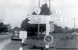

Left - Old "Totem Pole" fingerboard guide sign post at the Hwy 3 & Hwy 3A Junction at Chambers Corners, southwest of Welland. This photo illustrates the
typical destination sign layout at our early King's Highway junctions. These fingerboard signposts guided motorists towards their intended destinations at most major
highway junctions in Ontario up until the late 1940s. The DHO adopted larger destination signs for use at King's Highway junctions beginning in 1948, in an effort to
make the signs more legible to motorists traveling at higher speeds. See an
Enlarged Photo Here. Photo taken circa 1940. (Photo from Cameron Bevers' historical photograph collection - Original photographer unknown) Right - Circa 1940 postcard view of Hwy 3 approaching the Hwy 73 Junction in Aylmer. See an Enlarged Photo Here. (Photo from Cameron Bevers' historical photograph collection - Original photographer unknown) 
Left - Completed asphalt resurfacing in 1943 along a section of Hwy 3 between Nelles Corners and Jarvis, Contract #1943-375. This was one of several emergency
resurfacing contracts tendered in 1943 to repair broken pavement sections along the King's Highways which were damaged by heavy Wartime truck traffic. See an
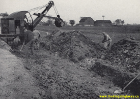
Enlarged Photo Here. Photo taken in 1943. (Photo courtesy of Ontario Ministry of Transportation - © King's Printer for Ontario, 1943) Right - Road base excavation and reconstruction along Hwy 3 near Dunnville. Heavy Wartime truck traffic coupled with an acute shortage of equipment, supplies and labour to properly maintain the highways caused an alarming deterioration of many King's Highways during World War II. Some sections of the highways were so badly damaged by Wartime truck traffic that they had to be fully rebuilt from the road base up, as was the case here. See an Enlarged Photo Here. Photo taken in 1945. (Photo courtesy of Ontario Ministry of Transportation - © King's Printer for Ontario, 1945) 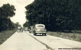
Above - Circa 1945 postcard view of Hwy 3 near Dutton. As this photo clearly illustrates, the section of Hwy 3 between Blenheim and St. Thomas was much busier
in its earlier days than it is now. Traffic volumes on this section of Hwy 3 peaked around 1960, and then dropped precipitously once the various stages of adjacent
Hwy 401 were completed and opened to traffic. When the MTO downloaded this section of Hwy 3 in Southwestern Ontario in the late 1990s, the highway carried fewer than
900 vehicles per day. By comparison, over 2,500 vehicles per day used this section of Hwy 3 back in 1960, before Hwy 401 was built through the area. (Photo from Cameron Bevers' historical photograph collection - Original photographer unknown) 

Left - View of the Ambassador Bridge at the end of Hwy 3 in Windsor, as seen from Hwy 18
(Riverside Drive). This International Bridge links Canada and the United States across the Detroit River. Unlike most of the crossings between Canada and the United
States located within Ontario, the Ambassador Bridge is privately owned and operated. The Ambassador Bridge has been open to traffic since 1929. See an
Enlarged Photo Here. Photo taken September 23, 1949. (Photo courtesy of Ontario Ministry of Transportation - © King's Printer for Ontario, 1949) Right - Circa 1953 postcard view of traffic arriving in Windsor from Detroit, Michigan on the Ambassador Bridge at the end of Hwy 3. See an Enlarged Photo Here. Photo taken circa 1953. (Photo courtesy of Sigal Brothers Publishing, Windsor) 
Above - New zone striping on a resurfaced section of Hwy 3, six miles east of Blenheim. Photo taken on July 7, 1955. See an
Enlarged Photo here. (Photo courtesy of Ontario Ministry of Transportation - © King's Printer for Ontario, 1955) 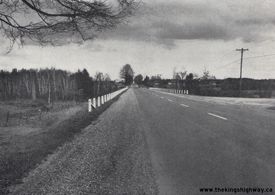

Left - Completed hot mix asphalt resurfacing 3 miles west of Simcoe on Hwy 3, Contract #1954-403. See an
Enlarged Photo Here. Photo taken on November 3, 1955. (Photo courtesy of Ontario Ministry of Transportation - © King's Printer for Ontario, 1955) Right - Facing west along Hwy 3 towards the Hwy 24 Junction from the Lynn River Bridge in Simcoe. The Lynn River Bridge on Hwy 3 was widened to a four-lane structure under Contract #1956-34. This photo shows the original bridge over the Lynn River before widening, which was initially completed in 1923. Compare this 1956 photo with my 2006 Photo of the Lynn River Bridge, taken from the same location 50 years later. See an Enlarged Photo Here. Photo taken on November 1, 1956. (Photo courtesy of Ontario Ministry of Transportation - © King's Printer for Ontario, 1956) 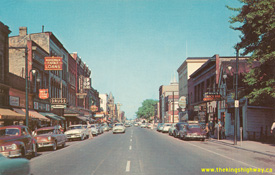
Above - Circa 1956 postcard view of Hwy 3 (Talbot Street) in Downtown St. Thomas, facing east from Mary Street. See an
Enlarged Photo Here. (Photo courtesy of Victor Aziz) 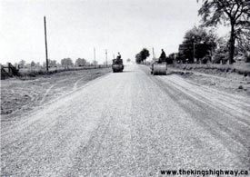
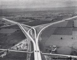
Left - Grading in preparation for new asphalt pavement construction on Hwy 3, about 3 miles east of Palmyra. Photo taken on July 25, 1956. (Photo courtesy of Ontario Ministry of Transportation - © King's Printer for Ontario, 1956) Right - Aerial view of the Windsor High-Speed Interchange at the diverge between the Hwy 401 Tunnel and Bridge Routes in 1958. The Hwy 401 Bridge Route exited left to join Hwy 3 (Huron Church Road) to the Ambassador Bridge, while the Hwy 401 Tunnel Route exited right to join Hwy 3B to the Detroit-Windsor Tunnel. See an Enlarged Photo Here. Photo taken in 1958. (Photo courtesy of Ontario Ministry of Transportation - © King's Printer for Ontario, 1958) 

Left - Reconstructed section of Hwy 3 (John Pound Road) approaching the new Otter Creek Bridge on the western approach to Tillsonburg. See an
Enlarged Photo Here. Photo taken in 1958. (Photo courtesy of Ontario Ministry of Transportation - © King's Printer for Ontario, 1958) Right - New NYCR Overhead on Hwy 3 at the eastern entrance to St. Thomas. Built under Contract #1956-221, this new four-lane structure replaced a narrow railway overhead on the original route of Hwy 3. The old overhead was constructed in 1908 and remained in service on Hwy 3 until the 1950s, by which time the busy structure had become a major traffic bottleneck. The new structure and diversion of Hwy 3 on the approaches to the bridge were built at a cost of $414,000 (in 1958 Dollars), the equivalent of $4.1 Million in 2022 Dollars. See an Enlarged Photo Here. Photo taken in 1958. (Photo courtesy of Ontario Ministry of Transportation - © King's Printer for Ontario, 1958) 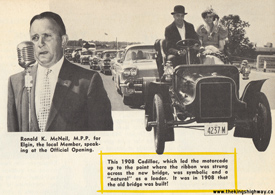
Above - Photo montage from the Official Opening Ceremony of the NYCR Overhead on Hwy 3 at the eastern entrance to St. Thomas in 1958. The new bridge and
diversion of Hwy 3 was a major improvement over the old narrow structure situated on the crooked original alignment of Hwy 3, which had sharp turns at either end of
the bridge. The bridge opened to much fanfare, with M.P.P. Ron McNeil presiding over the ceremony. The first vehicle to cross the new bridge was a 1908 Cadillac,
which just happened to be the year the old NYCR structure was built. This photo montage was featured in the July/August 1958 Edition of "DHO News" - a periodical
newsletter issued to DHO employees. See an Enlarged Photo Here. Photos taken on July 17, 1958. (Photo courtesy of Ontario Ministry of Transportation - © King's Printer for Ontario, 1958) 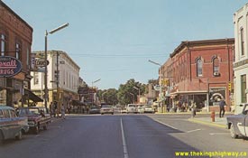
Above - Circa 1960 postcard view of Talbot Street (Hwy 3) facing west at Erie Street (Hwy 18) in Downtown Leamington. See an
Enlarged Photo Here. (Photo courtesy of Sigal Brothers Ltd, Windsor) 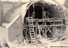
Above - Construction of a barrel arch culvert extension at Nineteen Mile Creek on Hwy 3 near New Sarum in 1961 This culvert extension was constructed by Elgin
Construction Company in order to provide a wider structure for Hwy 3 across the creek. The original barrel arch structure was completed in 1939. See an
Enlarged Photo Here. Photo taken in 1961. (Photo courtesy of Ontario Ministry of Transportation - © King's Printer for Ontario, 2023) 
Above - Twin temporary Bailey bridges on Hwy 3 at the site of the new Catfish Creek Bridge at Orwell, located between Aylmer and St. Thomas. See an
Enlarged Photo Here. Photo taken in 1962. (Photo courtesy of Ontario Ministry of Transportation - © King's Printer for Ontario, 1962) 
Above - Circa 1967 postcard view of Hwy 3 (Talbot Street) in Downtown St. Thomas, facing east towards Hincks Street. See an
Enlarged Photo Here. (Photo courtesy of L.F. Charter) 
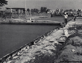
Left - New culvert on Hwy 3 west of Blenheim, Contract #1966-204. See an
Enlarged Photo Here. Photo taken in 1967. (Photo courtesy of Ontario Ministry of Transportation - © King's Printer for Ontario, 1967) Right - Concrete paving operations underway on Huron Church Road (Hwy 3) at Tecumseh Road in Windsor. See an Enlarged Photo Here. Photo taken in 1968. (Photo courtesy of Ontario Ministry of Transportation - © King's Printer for Ontario, 1968) 

Left - Completed reconstruction of Hwy 3 between Blenheim and Port Alma, Contract #1967-33. See an
Enlarged Photo Here. Photo taken in 1968. (Photo courtesy of Ontario Ministry of Transportation - © King's Printer for Ontario, 1968) Right - Grading operations underway on the Essex Bypass (Hwy 3 New), Contract #1970-104. See an Enlarged Photo Here. Photo taken in 1970. (Photo courtesy of Ontario Ministry of Transportation - © King's Printer for Ontario, 1970) 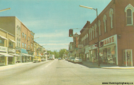
Above - Circa 1970 postcard view of Hwy 3 (Talbot Street) in Downtown Aylmer, facing east from the Hwy 73 Junction. See an
Enlarged Photo Here. (Photo courtesy of Eric Green) 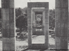

Left - Otter Creek Bridge under construction on the Tillsonburg Bypass (Hwy 3 New), Contract #1970-193. See an
Enlarged Photo Here. Photo taken in 1971. (Photo courtesy of Ontario Ministry of Transportation - © King's Printer for Ontario, 1971) Right - Laying hot mix asphalt on the Tillsonburg Bypass (Hwy 3 New), Contract #1972-33. See an Enlarged Photo Here. Photo taken in 1973. (Photo courtesy of Ontario Ministry of Transportation - © King's Printer for Ontario, 1973) 
Above - Postcard view of Hwy 3 (Talbot Street) in Downtown Blenheim in 1974, facing west from the Hwy 40 Junction at Chatham Street. See an
Enlarged Photo Here. Photo taken in 1974. (Photo courtesy of Hartman's Studio, Harrow) 
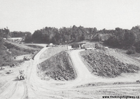
Left - Heavy grading between Wellington Road and Talbotville on Hwy 3 New, Contract #1978-96. See an
Enlarged Photo Here. Photo taken in 1978. (Photo courtesy of Ontario Ministry of Transportation - © King's Printer for Ontario, 1978) Right - Kettle Creek Bridge under construction on the St. Thomas Expressway (Hwy 3 New), Contract #1979-20. See an Enlarged Photo Here. Photo taken in 1979. (Photo courtesy of Ontario Ministry of Transportation - © King's Printer for Ontario, 1979) 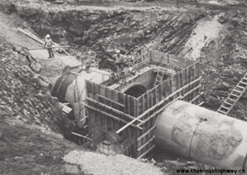
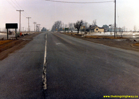
Left - Storm sewer construction on the St. Thomas Expressway (Hwy 3 New), Contract #1979-20. See an
Enlarged Photo Here. Photo taken in 1980. (Photo courtesy of Ontario Ministry of Transportation - © King's Printer for Ontario, 1980) Right - Facing west along Hwy 3 towards Cayuga from the Hwy 56 Junction near Canfield. See an Enlarged Photo Here. Photo taken on March 12, 1982. (Photo courtesy of Ontario Ministry of Transportation - © King's Printer for Ontario, 2023) 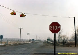

Left - Junction of Hwy 3 & Hwy 56 near Canfield, facing north towards Hamilton. See an
Enlarged Photo Here. Photo taken on March 12, 1982. (Photo courtesy of Ontario Ministry of Transportation - © King's Printer for Ontario, 2023) Right - Facing east along Hwy 3 towards Canfield from the Hwy 56 Junction. See an Enlarged Photo Here. Photo taken on March 12, 1982. (Photo courtesy of Ontario Ministry of Transportation - © King's Printer for Ontario, 2023) 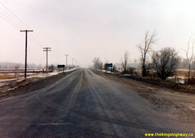

Left - Facing north along Hwy 56 towards Hamilton from the Hwy 3 Junction between Cayuga and Canfield. See an
Enlarged Photo Here. Photo taken on March 12, 1982. (Photo courtesy of Ontario Ministry of Transportation - © King's Printer for Ontario, 2023) Right - Beginning of the Queen Elizabeth Way at the Peace Bridge in Fort Erie in 1993. The overhead sign in the background was one of the only instances where the Queen Elizabeth Way's name was fully spelled out on the sign, rather than being abbreviated as "QEW". Traffic bound for Hwy 3 was directed to exit the Queen Elizabeth Way at Central Avenue. It is particularly interesting to note that the distant City of Windsor was listed as a control city for Hwy 3, along with the nearby destinations of Fort Erie and Crystal Beach. See an Enlarged Photo Here. Photo taken on May 27, 1993. (Photo courtesy of Ontario Ministry of Transportation - © King's Printer for Ontario, 2015)
Continue on to King's Highway 3 Present Day Photos: Windsor to Wheatley
|
|---|
Links to Adjacent King's Highway Photograph Pages:
Back to King's Highway 2 Photos /
King's Highway 3 History /
On to King's Highway 4 Photos
Ontario Highway History - Main Menu / Back to List of Highways Website contents, photos & text © 2002-2025, Cameron
Bevers (Webmaster) - All Rights Reserved / Contact Me
|
|---|