
| 
| |
|
|
This page contains present day photos (Year 2000 to date) of Ontario's King's Highway 401, arranged by location from the
Highway 6 Interchange near Guelph easterly to the Highway 25 Interchange in Milton. All photographs displayed on this page were taken by the Webmaster (Cameron
Bevers), unless specifically noted otherwise. Click on any thumbnail to see a larger image!
Please note that all photographs displayed on this
website are protected by copyright. These photographs must not be reproduced, published,
electronically stored or copied, distributed, or posted onto other websites without
my written permission. If you want to use photos from this website, please
email me first for permission. Thank-you!
|
|---|
|
Page 19: Present Day King's Highway 401 Photographs (Hwy 6 to Hwy 25)

Left - Hwy 6 South (Brock Road) Overpass on Hwy 401 north of Morriston. This four-span concrete box girder structure was completed in 1959. See an
Enlarged Photo Here. (Photograph taken on April 12, 2009 - © Cameron Bevers) Right - Facing north across the Hwy 6 Overpass on Hwy 401. Heading northbound, Hwy 6 runs concurrently with westbound Hwy 401 for 4 km. The overlapped route of Hwy 6 & Hwy 401 is marked on Hwy 6 itself as seen here, but is not actually marked along the freeway. Up until the 1970s, Hwy 6 used to continue north from this interchange towards Guelph via Brock Road. Originally, this was the only interchange for Guelph along Hwy 401. Today, traffic can access Guelph from Hwy 401 via either Brock Road (Old Hwy 6) or the Hwy 6 Bypass (Hanlon Parkway). See an Enlarged Photo Here. (Photograph taken on April 12, 2009 - © Cameron Bevers) 

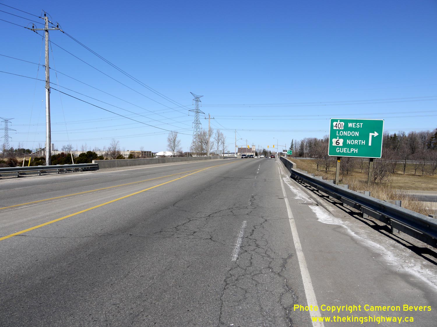
Left - Sign marking the entrance ramp to westbound Hwy 401. Hwy 6 turns right at the north ramp terminal and follows Hwy 401 along a short concurrent routing
between Exit #299 (Hwy 6 South) and the Hanlon Parkway at Exit #295 (Hwy 6 North). The Hanlon Parkway was built in the 1970s to divert through traffic on Hwy 6 around
Downtown Guelph. See an Enlarged Photo Here. (Photograph taken on April 12, 2009 - © Cameron Bevers) Right - Facing east along Hwy 401 towards Toronto from the Hwy 6 South Overpass near Morriston. The ramps at the Hwy 6 South Interchange are in an "A-2" partial cloverleaf configuration. This type of interchange ramp configuration is rather uncommon in Ontario. It is rather odd that Hwy 6 was not built with a full eight-ramp cloverleaf interchange when Hwy 401 was first built, especially considering the important role that Hwy 6 has always played in Ontario's highway network. The Hwy 6 Interchange was one of the only non-cloverleaf provincial highway interchanges along Hwy 401 between London and Toronto. See an Enlarged Photo Here. (Photograph taken on April 12, 2009 - © Cameron Bevers) 

Left - Facing west along Hwy 401 towards Cambridge from the Hwy 6 South Overpass near Morriston. See an
Enlarged Photo Here. (Photograph taken on April 12, 2009 - © Cameron Bevers) Right - Western side of the Hwy 6 South Overpass on Hwy 401. This concrete box girder structure is arguably one of the least attractive bridges on Hwy 401 between Cambridge and Toronto. The recent bridge rehabilitation project certainly didn't help, when the old steel handrails were removed and replaced by concrete barriers. See an Enlarged Photo Here. (Photograph taken on April 12, 2009 - © Cameron Bevers) 

Left - Wellington Road 36 Overpass on Hwy 401 southeast of Guelph. This four-span prestressed concrete girder structure was completed in 1960. See an
Enlarged Photo Here. (Photograph taken on October 16, 2010 - © Cameron Bevers) Right - Hwy 401 ascends this long grade at the Wellington Road 36 Overpass near Morriston. Hwy 401 reaches its maximum elevation above sea level between Toronto and Cambridge at the crest of this grade, which lies between the Wellington Road 36 Overpass and the Hwy 6 South Interchange located a short distance to the west. The elevation of the eastbound lanes at the crest of the Morriston Grade is just slightly under 335 metres (1,099 feet) above sea level. Overall, the crest of the Morriston Grade is the third-highest elevation reached along Hwy 401. The highest elevation reached along the entire route of Hwy 401 is located west of Cambridge at the Hwy 97 Interchange. At that point, the westbound lanes of Hwy 401 briefly crest above 336.4 metres (1,104 feet) in elevation. See an Enlarged Photo Here. (Photograph taken on October 16, 2010 - © Cameron Bevers) 

Left - Facing east along Hwy 401 towards Milton from the Wellington Road 36 Overpass. See an
Enlarged Photo Here. (Photograph taken on October 16, 2010 - © Cameron Bevers) Right - Eastern side of the Wellington Road 36 Overpass on Hwy 401. This structure is located about 2 km east of the Hwy 6 South Interchange at Morriston. Despite a fairly substantial realignment of Wellington Road 36 during the initial construction of Hwy 401, this long structure was built on a considerable skew across the freeway. See an Enlarged Photo Here. (Photograph taken on October 16, 2010 - © Cameron Bevers) 

Left - Structure identification number and date stamp (2004) on the Wellington Road 36 Overpass. In this particular instance, the date "2004" refers to the
year of the last major structural rehabilitation, and not the actual construction year of the bridge. The Wellington Road 36 Overpass was completed in 1960. See an
Enlarged Photo Here. (Photograph taken on October 16, 2010 - © Cameron Bevers) Right - Facing east along Hwy 401 near Wellington Road 36. All sections of Hwy 401 between the Hwy 402 Interchange in London and the Hwy 410 Interchange in Mississauga are now at least six lanes (three lanes per direction), with some localized sections having eight lanes or more. When the Milton-to-Preston (Cambridge) section of Hwy 401 first opened to traffic in 1960, the highway had only four lanes (two lanes per direction). See an Enlarged Photo Here. (Photograph taken on April 11, 2009 - © Cameron Bevers) 

Left - Watson Road (Puslinch Township Concession Road 10) Overpass on Hwy 401 between Morriston and Milton, located about 5 km east of the Hwy 6 South
Interchange. This two-span concrete rigid frame structure was completed in 1959. See an
Enlarged Photo Here. (Photograph taken on October 16, 2010 - © Cameron Bevers) Right - View of Hwy 401, facing west from the Watson Road Overpass near Badenoch. See an Enlarged Photo Here. (Photograph taken on October 16, 2010 - © Cameron Bevers) 

Left - Facing east along Hwy 401 towards Milton from the Watson Road Overpass. See an
Enlarged Photo Here. (Photograph taken on October 16, 2010 - © Cameron Bevers) Right - Close-up of the steel and concrete handrail design on the Watson Road Overpass. See an Enlarged Photo Here. (Photograph taken on October 16, 2010 - © Cameron Bevers) 

Left - Facing south across the Watson Road Overpass on Hwy 401 near Badenoch, located southeast of Guelph. See an
Enlarged Photo Here. (Photograph taken on October 16, 2010 - © Cameron Bevers) Right - Facing north across the Watson Road Overpass on Hwy 401 towards Badenoch. See an Enlarged Photo Here. (Photograph taken on October 16, 2010 - © Cameron Bevers) 

Left - Western side of the Watson Road Overpass on Hwy 401 between Morriston and Milton. Two-span concrete rigid frame designs similar to this one were first
built along the Middle Road Superhighway (QEW) in 1936-1937. Numerous other structures of this general design appeared along the QEW, Hwy 400 and Hwy 401 from the
1940s up until about 1960, when the design quickly declined in popularity. In my personal opinion, these were among the most aesthetically-pleasing freeway structures
ever built in Ontario. See an Enlarged Photo Here. (Photograph taken on October 16, 2010 - © Cameron Bevers) Right - Eastern side of the Watson Road Overpass on Hwy 401 near Badenoch. See an Enlarged Photo Here. (Photograph taken on October 16, 2010 - © Cameron Bevers) 

Left - Facing east along Hwy 401 towards Milton from the Halton-Wellington County Boundary. This political boundary also coincides with the Ministry of
Transportation of Ontario's administrative boundary between MTO Central Region (Downsview) and MTO West Region (London). See an
Enlarged Photo Here. (Photograph taken on October 16, 2010 - © Cameron Bevers) Right - Facing east along Hwy 401 towards Milton approaching the First Line Overpass near Campbellville. See an Enlarged Photo Here. (Photograph taken on April 11, 2009 - © Cameron Bevers) 

Left - Rock cut along Hwy 401 approaching the First Line Overpass near Campbellville. As Hwy 401 approaches the Niagara Escarpment near Milton, the highway
passes through an area of very shallow and sometimes exposed bedrock. Rock cuts such as this are very unusual along Hwy 401 in Southwestern Ontario. Rock cuts become
far more common along Hwy 401 further to the east in the Napanee, Kingston and Brockville areas. Rocks were excavated from this cut during the initial construction of
Hwy 401 back in the 1950s, in order to construct a road base for other areas of the highway near Badenoch which pass through some rather swampy areas. See an
Enlarged Photo Here. (Photograph taken on October 16, 2010 - © Cameron Bevers) Right - A tiny natural cave once existed in the rock face along the north side of Hwy 401 near First Line. When this section of Hwy 401 was widened from four to six lanes in 1994-1995, this rock cut was also widened to create additional space for the expanded highway. The widening of the rock cut removed all traces of the cave. See an Enlarged Photo Here. (Photograph taken on October 16, 2010 - © Cameron Bevers) 

Left - Facing west along Hwy 401 towards Cambridge from the First Line Overpass on Hwy 401 near Campbellville. See an
Enlarged Photo Here. (Photograph taken on October 16, 2010 - © Cameron Bevers) Right - Facing north across the First Line Overpass on Hwy 401 near Campbellville. This is one of only three bridges crossing Hwy 401 in the rather sparsely-populated area lying between Morriston and Campbellville. Since the freeway is in a cut at this location, First Line more or less follows the original ground line while crossing this overpass. See an Enlarged Photo Here. (Photograph taken on October 16, 2010 - © Cameron Bevers) 

Left - First Line Overpass on Hwy 401 between Morriston and Milton. This two-span concrete rigid frame structure was completed in 1959. See an
Enlarged Photo Here. (Photograph taken on October 16, 2010 - © Cameron Bevers) Right - An older cedar post and cable guide rail installation at the First Line Overpass on Hwy 401. Historically, the Department of Highways of Ontario (DHO) often did not connect roadside barriers to bridges. On newer bridges, or older bridges which have been rehabilitated, roadside barriers are directly connected to the barrier walls of a bridge. See an Enlarged Photo Here. (Photograph taken on October 16, 2010 - © Cameron Bevers) 

Left - The two-span concrete rigid frame design of the First Line Overpass is somewhat similar to the bridges at Watson Road lying to the west and Guelph Line
lying to the east. The First Line Overpass is located about 12 km west of the Hwy 25 Interchange in Milton. See an
Enlarged Photo Here. (Photograph taken on October 16, 2010 - © Cameron Bevers) Right - Facing east along Hwy 401 towards Milton from the First Line Overpass near Campbellville. See an Enlarged Photo Here. (Photograph taken on October 16, 2010 - © Cameron Bevers) 

Left - Facing south across the First Line Overpass on Hwy 401 near Campbellville. See an
Enlarged Photo Here. (Photograph taken on October 16, 2010 - © Cameron Bevers) Right - Eastern side of the First Line Overpass on Hwy 401 near Campbellville. See an Enlarged Photo Here. (Photograph taken on October 16, 2010 - © Cameron Bevers) 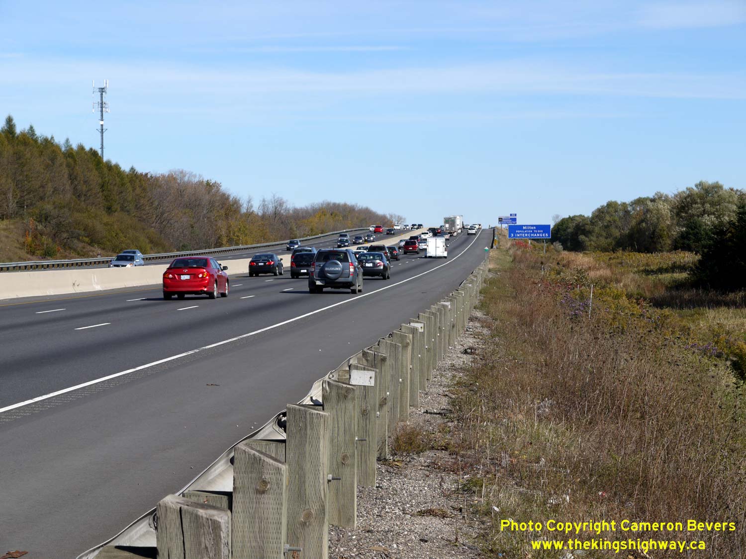

Left - Facing east along Hwy 401 towards Milton near the Guelph Junction (Campbellville) Canadian Pacific Railway (CPR) Overhead. See an
Enlarged Photo Here. (Photograph taken on October 16, 2010 - © Cameron Bevers) Right - Facing west along Hwy 401 towards Cambridge from the Guelph Line Overpass in Campbellville. This interchange was reconfigured slightly in 2007-2008. The inner loop ramp in the southwest quadrant of the interchange, which can be seen entering the highway in this photo at left, was replaced with a new ramp from nearby Reid Side Road. See an Enlarged Photo Here. (Photograph taken on September 30, 2007 - © Cameron Bevers) 

Left - Guelph Line (Halton Road 1) Overpass on Hwy 401 in Campbellville. This two-span concrete rigid frame structure was completed in 1959. See an
Enlarged Photo Here. (Photograph taken on September 30, 2007 - © Cameron Bevers) Right - Facing north across the Guelph Line Overpass on Hwy 401. Note the narrow lane widths across the bridge. As a result of the interchange reconfiguration at Guelph Line in 2007-2008, the bridge was re-striped with only two lanes (one lane in each direction). Once the inner loop ramp to eastbound Hwy 401 was removed, it was no longer necessary to provide a separate speed-change lane to the inner loop ramp. Instead, southbound traffic on Guelph Line now turns right onto Reid Side Road in order to access the ramp to eastbound Hwy 401. See an Enlarged Photo Here. (Photograph taken on September 30, 2007 - © Cameron Bevers) 

Left - The Guelph Line Overpass has only one sidewalk, located on the western side of the structure. See an
Enlarged Photo Here. (Photograph taken on September 30, 2007 - © Cameron Bevers) Right - Close-up of the steel and concrete handrail design on the Guelph Line Overpass. See an Enlarged Photo Here. (Photograph taken on September 30, 2007 - © Cameron Bevers) 

Left - Facing east along Hwy 401 towards Toronto from the Guelph Line Overpass in Campbellville. From this point, Hwy 401 begins a steady 6 km descent down the
Niagara Escarpment. The Guelph Line Interchange is located about 8 km west of the Hwy 25 Interchange in Milton. See an
Enlarged Photo Here. (Photograph taken on September 30, 2007 - © Cameron Bevers) Right - Eastern side of the Guelph Line Overpass on Hwy 401. This handsome two-span concrete rigid frame structure is one of several bridges of this general design located along Hwy 401 between the Hwy 25 Interchange in Milton and the Drumbo Road (Oxford Road 29) Interchange near Woodstock. See an Enlarged Photo Here. (Photograph taken on September 30, 2007 - © Cameron Bevers) 

Left - Long on-ramp from northbound Guelph Line to eastbound Hwy 401. This elongated ramp was necessary in order to match the profile of the freeway at the
merge point, since Hwy 401 begins its descent down the Niagara Escarpment immediately east of the Guelph Line Overpass. Interestingly, this particular ramp was not
part of the original Guelph Line Interchange built in the late 1950s. This ramp was constructed during an interchange retrofit project which was carried out in 1978.
See an Enlarged Photo Here. (Photograph taken on September 30, 2007 - © Cameron Bevers) Right - Old inner loop ramp from southbound Guelph Line to eastbound Hwy 401. This loop ramp was closed and demolished during the reconstruction of the Guelph Line Interchange in 2007-2008. Access to eastbound Hwy 401 from southbound Guelph Line is now provided by a new ramp from nearby Reid Side Road. The removal of the old inner loop ramp allowed for an expansion and relocation of the adjacent MTO carpool lot (seen here at left), which was frequently operating at full capacity on weekdays. The new ramp configuration at Guelph Line also provided more convenient access to the carpool lot by Hwy 401 commuters. See an Enlarged Photo Here. (Photograph taken on September 30, 2007 - © Cameron Bevers) 

Left - Campbell Avenue Underpass on Hwy 401 near Campbellville. This single-span concrete rigid frame structure was completed in 1959. See an
Enlarged Photo Here. (Photograph taken on October 16, 2010 - © Cameron Bevers) Right - Northern side of the Campbell Avenue Underpass on Hwy 401. This bridge was replaced with a new structure during a multi-year reconstruction project which took place between 2016 and 2018. The Campbell Avenue Underpass is located about 7 km west of the Hwy 25 Interchange in Milton. See an Enlarged Photo Here. (Photograph taken on October 16, 2010 - © Cameron Bevers) 

Left - Hwy 401 descends the Niagara Escarpment between Campbellville and Milton. This is one of the most scenic sections of Hwy 401 west of Toronto. See an
Enlarged Photo Here. (Photograph taken on April 12, 2009 - © Cameron Bevers) Right - Kelso Mountain appears just beyond this sweeping curve on Hwy 401 west of Milton. This precipitous rock outcrop is one of Southern Ontario's most prominent geologic formations. The escarpment is protected within Kelso Conservation Area. Note the traces of spring snow that still remain at the nearby Glen Eden Ski Hill. See an Enlarged Photo Here. (Photograph taken on April 12, 2009 - © Cameron Bevers) 

Left - Appleby Line Underpass on Hwy 401 near Campbellville. This single-span concrete rigid frame structure was completed in 1959. See an
Enlarged Photo Here. (Photograph taken on October 16, 2010 - © Cameron Bevers) Right - Northern side of the Appleby Line Underpass on Hwy 401. Like the nearby Campbell Avenue Underpass, the Appleby Line Underpass was replaced with a new structure during a multi-year reconstruction project which took place between 2016 and 2018. The Appleby Line Underpass is located about 5 km west of the Hwy 25 Interchange in Milton. See an Enlarged Photo Here. (Photograph taken on October 16, 2010 - © Cameron Bevers) 

Left - As originally constructed in the 1950s, the underpass at Appleby Line consisted of two twin structures. When Hwy 401 was widened from four to six
lanes in 1994, the twin structures were joined together to accommodate the additional lanes on the freeway above. Note the much newer structure sandwiched in between
the two original structures. See an Enlarged Photo Here. (Photograph taken on October 16, 2010 - © Cameron Bevers) Right - Scenic autumn view of Hwy 401 and Kelso Mountain, located about 4 km west of the Hwy 25 Interchange in Milton. See an Enlarged Photo Here. (Photograph taken on October 16, 2010 - © Cameron Bevers) 

Left - Tremaine Road (Halton Road 22) Overpass on Hwy 401 in Milton. This two-span prestressed concrete girder structure was completed in 1959. See an
Enlarged Photo Here. (Photograph taken on October 16, 2010 - © Cameron Bevers) Right - View of Hwy 401, facing west from the Tremaine Road Overpass on Hwy 401 in Milton. See an Enlarged Photo Here. (Photograph taken on October 16, 2010 - © Cameron Bevers) 

Left - Facing south across the Tremaine Road Overpass on Hwy 401 in Milton. See an
Enlarged Photo Here. (Photograph taken on October 16, 2010 - © Cameron Bevers) Right - Western side of the Tremaine Road Overpass on Hwy 401. Before Hwy 401 was widened to six lanes in the 1990s, the highway had a depressed grass median. Back in 1990, a truck lost control and drove into the grass median and subsequently collided with the Tremaine Road Overpass. The bridge was immediately closed for repairs, which included the full replacement of a damaged pier. Note that the westernmost pier of this bridge is newer than the other two. See an Enlarged Photo Here. (Photograph taken on October 16, 2010 - © Cameron Bevers) 

Left - Facing east along Hwy 401 towards the Hwy 25 Interchange in Milton. Compare this present-day photo to this
Historical 1959 Photo of the highway while it was still being built. A new interchange will
be constructed on Hwy 401 at a relocated Tremaine Road by the Regional Municipality of Halton in the coming years. The new interchange will be located about 500
metres east of the existing Tremaine Road Overpass. See an Enlarged Photo Here. (Photograph taken on October 16, 2010 - © Cameron Bevers) Right - Eastern side of the Tremaine Road Overpass on Hwy 401. Once Tremaine Road is relocated to the new interchange, the old structure seen here will be removed and not replaced. The new interchange is required to serve the rapidly-growing business parks located north of Hwy 401 in Milton. See an Enlarged Photo Here. (Photograph taken on October 16, 2010 - © Cameron Bevers) 

Left - Facing north across the Tremaine Road Overpass on Hwy 401 in Milton. See an
Enlarged Photo Here. (Photograph taken on October 16, 2010 - © Cameron Bevers) Right - Eastern side of the Hwy 25 Overpass on Hwy 401 in Milton. This two-span concrete rigid frame girder structure was completed in 1959. See an Enlarged Photo Here. (Photograph taken on October 16, 2010 - © Cameron Bevers) 

Left - Facing east along Hwy 401 from the Hwy 25 Overpass in Milton. For about a kilometre east of this interchange, Hwy 401 has a fourth eastbound lane. This
lane develops from the inner loop ramp from southbound Hwy 25. This extra lane provides slow trucks with an opportunity to pick up speed before merging with the
through lanes of Hwy 401. See an Enlarged Photo Here. (Photograph taken on October 16, 2010 - © Cameron Bevers) Right - Facing east along Hwy 401 towards Toronto from the Hwy 25 Overpass in Milton. The full eight-ramp cloverleaf interchange configuration at Hwy 25 was replaced by a standard "A-4" partial cloverleaf interchange in 1988. Until the nearby James Snow Parkway Interchange was built in 1982-1983, Milton's only direct access to Hwy 401 was at Hwy 25. See an Enlarged Photo Here. (Photograph taken on October 16, 2010 - © Cameron Bevers) 

Left - Facing south across the Hwy 25 Overpass on Hwy 401 in Milton. See an
Enlarged Photo Here. (Photograph taken on October 16, 2010 - © Cameron Bevers) Right - Facing north across the Hwy 25 Overpass on Hwy 401 in Milton. See an Enlarged Photo Here. (Photograph taken on October 16, 2010 - © Cameron Bevers) 

Left - Western side of the Hwy 25 Overpass on Hwy 401 in Milton. The Hwy 25 Overpass was one of the most aesthetically pleasing bridges on Hwy 401 in the
Toronto area. Sadly, the bridge was replaced during a reconstruction project in 2017-2018, in order to make way for a planned expansion of Hwy 401 in the area. See an
Enlarged Photo Here. (Photograph taken on October 16, 2010 - © Cameron Bevers) Right - Facing west along Hwy 401 towards Cambridge from the Hwy 25 Interchange in Milton. When Hwy 401 was first built, the new freeway temporarily ended at the Hwy 25 Interchange in Milton for almost a full year. The freeway was completed and opened to traffic between the Highway 10 Interchange near Toronto and Milton on November 26, 1959. Between Milton and Cambridge (Preston), Hwy 401 wasn't officially opened to traffic until November 17, 1960. See an Enlarged Photo Here. (Photograph taken on October 16, 2010 - © Cameron Bevers) 

Left - The Hwy 25 Overpass is a two-span concrete rigid frame girder structure. See an
Enlarged Photo Here. (Photograph taken on October 16, 2010 - © Cameron Bevers) Right - Green guide sign on the exit ramp from eastbound Hwy 401 in Milton approaching the traffic signals at Hwy 25. See an Enlarged Photo Here. (Photograph taken on June 14, 2008 - © Cameron Bevers)
Continue on to King's Highway 401 Photos: Hwy 25 to Hwy 407 ETR
|
|---|
Links to Adjacent King's Highway Photograph Pages:
Back to King's Highway 400 Photos /
King's Highway 401 History /
On to King's Highway 402 Photos
Ontario Highway History - Main Menu / Back to List of Highways Website contents, photos & text © 2002-2026, Cameron
Bevers (Webmaster) - All Rights Reserved / Contact Me
|
|---|