
| 
| |
|
|
This page contains historical photos of Ontario's King's Highway 401 dating from 1955 to 1959. All photographs displayed on
this page were taken by the Ontario Ministry of Transportation, unless specifically noted otherwise. Historical photographs are arranged in approximate chronological
order. Click on any thumbnail to see a larger image!
Please note that all photographs displayed on this
website are protected by copyright. These photographs must not be reproduced, published,
electronically stored or copied, distributed, or posted onto other websites without
my written permission. If you want to use photos from this website, please
email me first for permission. Thank-you!
|
|---|
|
Page 2: Historical King's Highway 401 Photographs (1955 to 1959)


Left - Moira River Bridge construction on the Trenton to Belleville section of Hwy 401. Photo taken on September 30, 1955. (Photo courtesy of Ontario Ministry of Transportation - © King's Printer for Ontario, 1955) Right - Huron Construction Company's paving operations on Hwy 401 between Tilbury and Windsor, Contract #1955-21. Photo taken on October 12, 1955. (Photo courtesy of Ontario Ministry of Transportation - © King's Printer for Ontario, 1955) 

Left - Completed concrete pavement on an unopened section of Hwy 401 between Tilbury and Windsor. Photo taken on October 12, 1955. (Photo courtesy of Ontario Ministry of Transportation - © King's Printer for Ontario, 1955) Right - Replacement Humber River Bridge on the Toronto Bypass (Hwy 401) west of the Weston Road Interchange in 1955. This new structure replaced the original Humber River Bridge, which was severely damaged by Hurricane Hazel in October, 1954. After assessing the storm damage, engineers were unable to figure out a way to repair the badly-damaged bridge. It was decided a few weeks following the storm to dynamite the old structure, which had never been opened to traffic, and build a brand new one in its place. Photo taken on October 28, 1955. (Photo courtesy of Ontario Ministry of Transportation - © King's Printer for Ontario, 1955) 

Left - Completed grading for the Hwy 401 & Hwy 19 Cloverleaf near Ingersoll, facing east towards Woodstock, Contract #1954-54. Photo taken on November 1, 1955. (Photo courtesy of Ontario Ministry of Transportation - © King's Printer for Ontario, 1955) Right - Department of Highways of Ontario (DHO) work crew from District #2 (London District) applying seed and mulch for slope stabilization at the newly-built Hwy 401 & Hwy 19 Cloverleaf south of Ingersoll, using a Finn Mulching Machine and Hydro Seeder. Photo taken on November 1, 1955. (Photo courtesy of Ontario Ministry of Transportation - © King's Printer for Ontario, 1955) 

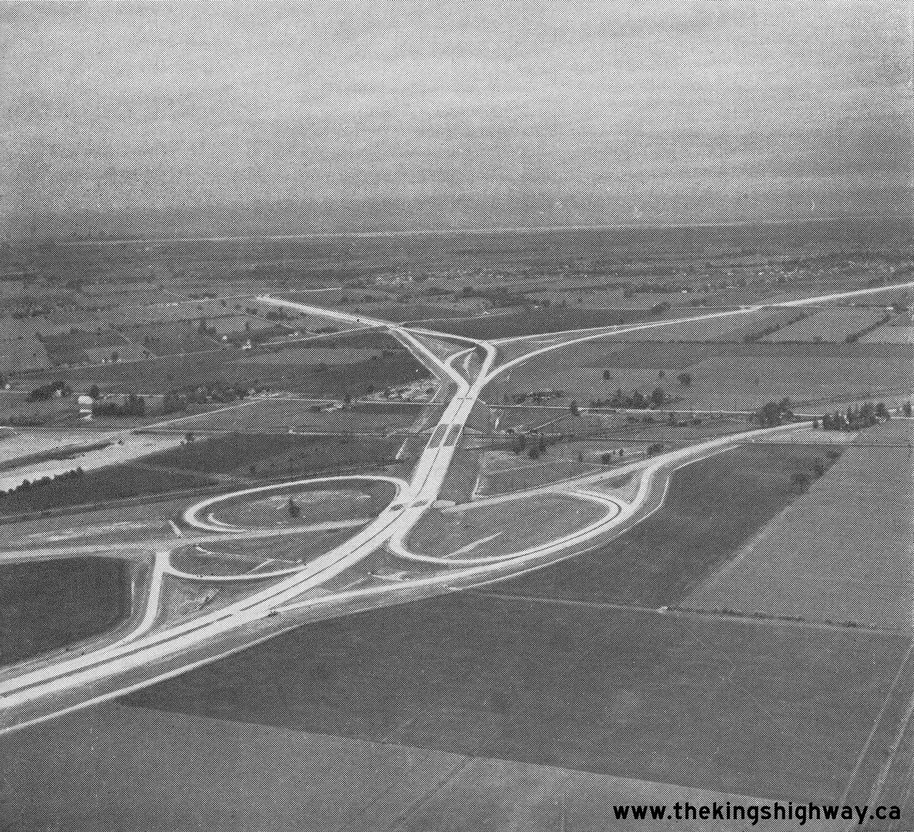
Left - Completed Woodstock Canadian National Railway (CNR) Overhead on Hwy 401 near the Hwy 2 Cloverleaf, Contract #1954-27. Photo taken on November 1, 1955. (Photo courtesy of Ontario Ministry of Transportation - © King's Printer for Ontario, 1955) Right - New cloverleaf interchange at Hwy 11 (Yonge Street) and Hwy 401 in Toronto. When the first phase of the Toronto Bypass (Hwy 401) opened to traffic in 1952, it ended at Yonge Street at a badly-skewed at-grade intersection. The new Yonge Street underpass and eight-ramp cloverleaf interchange was completed in 1953, although it didn't fully open to traffic until April, 1955. That month, the Hwy 401 extension from Yonge Street easterly to Bayview Avenue was completed and opened to traffic, which necessitated the full opening of the Hwy 11 (Yonge Street) Cloverleaf. Photo taken on November 4, 1955. See an Enlarged Photo Here. (Photo courtesy of Ontario Ministry of Transportation - © King's Printer for Ontario, 1955) 

Left - Steel frame for the Meadowvale Road Overpass on Hwy 401 in Toronto. Photo taken on July 1, 1956. (Photo courtesy of Ontario Ministry of Transportation - © King's Printer for Ontario, 2011) Right - Construction of the Meadowvale Road Overpass on Hwy 401 in Toronto. Photo taken on July 1, 1956. (Photo courtesy of Ontario Ministry of Transportation - © King's Printer for Ontario, 2011) 
Above - Completed Avon Road (today's Putnam Road) Underpass on Hwy 401 between London and Ingersoll. Photo taken on July 16, 1956. (Photo courtesy of Ontario Ministry of Transportation - © King's Printer for Ontario, 1956) 

Left - Hot mix asphalt paving operations on Hwy 401 near the Hwy 74 Interchange east of London. Photo taken on July 17, 1956. (Photo courtesy of Ontario Ministry of Transportation - © King's Printer for Ontario, 1956) Right - Completed asphalt surface on the new London to Woodstock section of Hwy 401 east of the Hwy 73 Interchange. Photo taken on July 17, 1956. (Photo courtesy of Ontario Ministry of Transportation - © King's Printer for Ontario, 1956) 
Above - Construction of the Wellington Road Overpass on Hwy 401 near London in 1956. The concrete rigid frame bridge shown above served as the main access
point to London from Hwy 401 until 2008, when the structure was demolished to permit the construction of additional lanes on Hwy 401 through the London area. Photo
taken on July 18, 1956. (Photo courtesy of Ontario Ministry of Transportation - © King's Printer for Ontario, 1956) 
Above - Construction of the New York Central Railway Overhead on a new section of Hwy 401 approaching Windsor. Photo taken on July 26, 1956. (Photo courtesy of Ontario Ministry of Transportation - © King's Printer for Ontario, 1956) 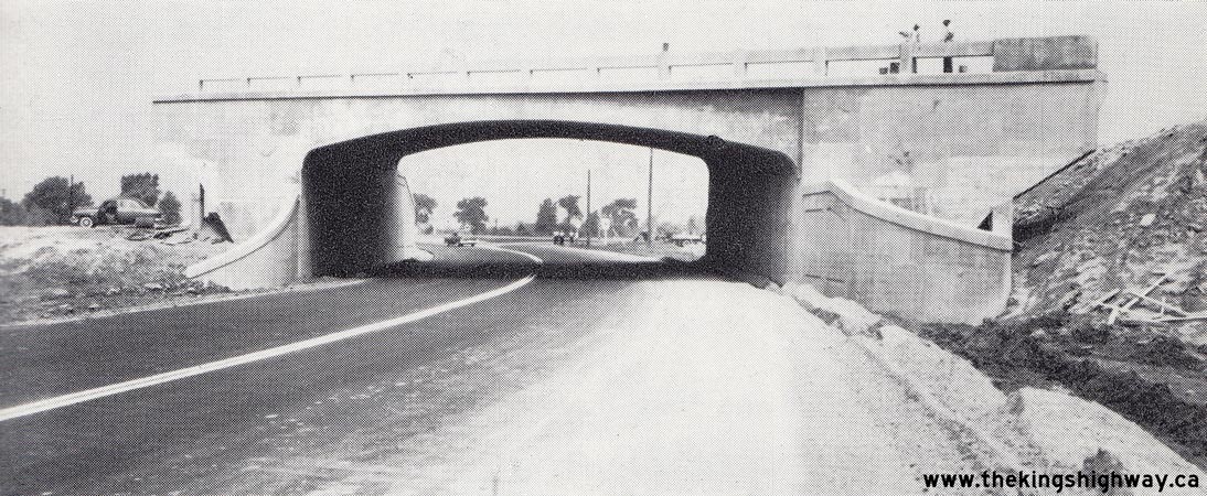
Above - Hwy 98 (Provincial Road) Interchange under construction on Hwy 401 south of Windsor, Contract #1955-59. See an
Enlarged Photo Here. Photo taken on July 26, 1956. (Photo courtesy of Ontario Ministry of Transportation - © King's Printer for Ontario, 1956) 
Above - Grading operations underway on a new section of Hwy 401 near Cornwall on Contract #1955-235, Sta. 267+00 facing west. Photo taken on August 8, 1956. (Photo courtesy of Ontario Ministry of Transportation - © King's Printer for Ontario, 1956) 
Above - Heavy grading on Hwy 401 near Gananoque on Contract #1955-198, Sta. 1122+00 facing west. Photo taken on August 23, 1956. (Photo courtesy of Ontario Ministry of Transportation - © King's Printer for Ontario, 1956) 
Above - Grading on Hwy 401 near Gananoque on Contract #1955-198, Sta. 1212+00 facing east. Photo taken on August 23, 1956. (Photo courtesy of Ontario Ministry of Transportation - © King's Printer for Ontario, 1956) 
Above - Construction of the new Cataraqui River Bridge on Hwy 401 in Kingston. Photo taken on August 22, 1956. (Photo courtesy of Ontario Ministry of Transportation - © King's Printer for Ontario, 1956) 

Left - Formwork for the new Canadian National Railway (CNR) Overhead on the Belleville Bypass section of Hwy 401. Photo taken on August 21, 1956. (Photo courtesy of Ontario Ministry of Transportation - © King's Printer for Ontario, 1956) Right - Moira River Bridge nearing completion on Hwy 401 north of Belleville. Photo taken on August 24, 1956. (Photo courtesy of Ontario Ministry of Transportation - © King's Printer for Ontario, 1956) 
Above - Officials from the Department of Highways of Ontario (DHO) at the ribbon-cutting ceremony for the final section of the Toronto Bypass (Hwy 401) from
Bayview Avenue to Hwy 2A on August 24, 1956. From left to right, they are M.A. Elson (Deputy Minister of Highways), W.J. Fulton (Director of Planning and Design) and
W.A. Clarke (DHO Chief Engineer). Photo taken on August 24, 1956. (Photo courtesy of Ontario Ministry of Transportation - © King's Printer for Ontario, 1956) 

Left - Aerial view of Hwy 401 in 1956 facing west from the Lansing Road Interchange (today's Port Union Road) in Scarborough. This photo shows the start of
the Toronto Bypass in the background and the old bypassed portion of Hwy 2A leading to Hwy 2 (Kingston Road). Compare this view of the highway in 1956, with this
recent aerial photo showing the area as it appears today. (Photo courtesy of Ontario Ministry of Transportation - © King's Printer for Ontario, 1956) Right - Aerial view of Hwy 401 at the Leslie Street Interchange in Toronto, facing north (1956) (Photo courtesy of Ontario Ministry of Transportation - © King's Printer for Ontario, 1956) 

Left - Concrete pavement on an unopened section of Hwy 401 between Windsor and Tilbury. Photo taken on July 26, 1956. (Photo courtesy of Ontario Ministry of Transportation - © King's Printer for Ontario, 1956) Right - Wilson Road Underpass on Hwy 401 in Oshawa. Photo taken on September 12, 1956. (Photo courtesy of Ontario Ministry of Transportation - © King's Printer for Ontario, 2011) 

Left - Farewell Creek Bridge on Hwy 401 in Oshawa. Photo taken on September 12, 1956. (Photo courtesy of Ontario Ministry of Transportation - © King's Printer for Ontario, 2018) Right - Base Line Road (now Bloor Street) Overpass and Interchange on Hwy 401 in Oshawa in 1956, facing east towards Bowmanville. Although it was reconfigured during the 1970s, the Bloor Street Interchange was one of two original interchanges which existed along the Oshawa-Newcastle section of Hwy 401 when this part of the highway first opened to traffic in November, 1952. The other original interchange was located at Liberty Street in Bowmanville. Intermediate interchanges were built later during the 1960s and 1970s at Courtice Road, Holt Road, Waverley Road and Bennett Road. Note the interesting "School Drive Slowly" sign at right, to warn motorists of the potential for pedestrians on the freeway. Although Hwy 401 has always been designated as a Controlled-Access Highway, pedestrians did occasionally cross or walk along Hwy 401 at that time. Changes were eventually made to the Highway Traffic Act to explicitly prohibit pedestrians and cyclists from using Controlled-Access Highways such as this, due to the obvious safety concerns this presented. Photo taken on September 12, 1956. See an Enlarged Photo Here. (Photo courtesy of Ontario Ministry of Transportation - © King's Printer for Ontario, 2018) 

Left - Soper Creek Bridge on Hwy 401 in Bowmanville. Photo taken on September 13, 1956. (Photo courtesy of Ontario Ministry of Transportation - © King's Printer for Ontario, 2012) Right - Bowmanville Creek Bridge on Hwy 401 in Bowmanville. Photo taken on September 13, 1956. (Photo courtesy of Ontario Ministry of Transportation - © King's Printer for Ontario, 2012) 

Left - Liberty Street Interchange and Underpass on Hwy 401 in Bowmanville. Photo taken on September 13, 1956. (Photo courtesy of Ontario Ministry of Transportation - © King's Printer for Ontario, 2012) Right - Construction of the Trent River Bridge and Hwy 33 Overpass on Hwy 401 north of Trenton (1956) (Photo courtesy of Ontario Ministry of Transportation - © King's Printer for Ontario, 1956) 

Left - Looking east along Hwy 401 from the Hwy 48 Cloverleaf in Scarborough. Of note here is the cardinal direction "EAST" tab underneath the Hwy 401 route
marker at left. Until the freeway age arrived in Ontario, direction tabs such as this were not used to sign Ontario's highways. Photo taken on November 19, 1956. (Photo © Archives of Ontario - Series RG-14-151-5-15, Photo #931) Right - Hwy 401 at Woodbine Avenue (Don Valley Parkway) in Toronto, facing east. Photo taken on November 19, 1956. See an Enlarged Photo Here. (Photo © Archives of Ontario - Series RG-14-151-5-15, Photo #924) 
Above - Facing east along Hwy 401 from the Leslie Street Interchange in Toronto in 1956. The Don Valley Parkway Interchange was built at the top of the hill in
the background of this photo about 10 years after this photo was taken. Note the extremely low traffic volumes on the Toronto Bypass at that time. Photo taken on
November 19, 1956. (Photo courtesy of Ontario Ministry of Transportation - © King's Printer for Ontario, 1956) 

Left - Ramp to the westbound Toronto Bypass (Hwy 401), at the Hwy 2A & Hwy 401 Interchange in Scarborough. Photo taken on November 19, 1956. (Photo courtesy of Ontario Ministry of Transportation - © King's Printer for Ontario, 1956) Right - Looking east along Hwy 401 at the Kennedy Road Cloverleaf in Scarborough. Photo taken on May 6, 1957. (Photo courtesy of Ontario Ministry of Transportation - © King's Printer for Ontario, 1957) 
Above - Newly-installed overhead guide signs on westbound Hwy 401 approaching the Lansing Road (now Port Union Road) Interchange in Scarborough in 1957. These
overhead signs were installed only moments before this photo was taken. In fact, the DHO's sign truck can be seen parked on the shoulder just a short distance up the
highway. As Ontario's freeway interchanges became progressively more complex in the 1950s, the DHO made increasing use of overhead signs to provide positive guidance
to motorists approaching major decision points such as this. This photo is also rather noteworthy in that it was the very first highway photo published on the front
cover of the Department's long-running monthly employee newsletter "DHO News" in May 1957. Photo taken on April 10, 1957. See an
Enlarged Photo Here. (Photo courtesy of Ontario Ministry of Transportation - © King's Printer for Ontario, 1957) 
Above - Evening rush hour traffic on the Toronto Bypass (Hwy 401), facing east from the Avenue Road (Hwy 11A) Cloverleaf. Photo taken on April 12, 1957. See an
Enlarged Photo Here. (Photo courtesy of Ontario Ministry of Transportation - © King's Printer for Ontario, 1957) 
Above - Facing east along the Toronto Bypass (Hwy 401) towards the Kennedy Road Cloverleaf in Scarborough. When Hwy 401 was first built through Scarborough in
the mid-1950s, Kennedy Road crossed over the Toronto Bypass. A new interchange was built at Kennedy Road in 1969-1970, during which the grade separation setup was
reversed so that Hwy 401 spanned over Kennedy Road. The lack of development around the Kennedy Road Cloverleaf at the time this photo was taken in the 1950s serves as
a dramatic reminder of Toronto's rapid Post-War urban expansion. Photo taken on May 6, 1957. (Photo courtesy of Ontario Ministry of Transportation - © King's Printer for Ontario, 1957) 
Above - Completed Leslie Street Underpass on Hwy 401 in Toronto. Photo taken on May 6, 1957. (Photo courtesy of Ontario Ministry of Transportation - © King's Printer for Ontario, 1957) 

Left - Overhead signs marking Hwy 2 and Hwy 401 (the Toronto Bypass) at the Hwy 2A & Hwy 401 Interchange in Scarborough in 1957. This interesting photo
shows some of Ontario's earliest overhead freeway junction signs. Although these overhead guide signs may seem relatively simple when compared to our freeway signs
today, these early experiments in overhead guide sign installation ultimately led to the development of the freeway sign standards that are in use today. The
westbound "exit" of Hwy 401 to the Toronto Bypass (which was a newer extension of Hwy 401) was particularly counterintuitive to motorists. Heading westbound, the
apparent "through highway" at this interchange was actually an exit from Hwy 401 onto a different route (Hwy 2A). These overhead guide signs helped to convey the
message that by continuing straight ahead, motorists would end up on Kingston Road (Hwy 2) and that one had to keep right at the fork to stay on Hwy 401. Photo taken
on May 13, 1957. (Photo courtesy of Ontario Ministry of Transportation - © King's Printer for Ontario, 1957) Right - Eastern terminus of the Toronto Bypass (Hwy 401) at Hwy 2A in Scarborough, facing west near the Lansing Road Interchange (today's Port Union Road). When the new Toronto Bypass section of Hwy 401 was built in the mid-1950s, it left behind a short 2-mile section of the original Toronto-Oshawa Highway (Hwy 2A). When it was first completed in 1947, the Toronto-Oshawa Highway (Hwy 2A) continued straight ahead to join Hwy 2 (Kingston Road) at West Hill. During the early 1970s, this confusing interchange was reconfigured so that Hwy 401 became the "through highway" at the interchange and Hwy 2A became the exiting highway. The old interchange configuration seen here likely caught many early Hwy 401 motorists by surprise heading westbound, when they discovered (most likely too late) that they were supposed to keep right at the fork to stay on Hwy 401. Although the new overhead signing helped, the revised interchange at Hwy 2A & Hwy 401 built in the 1970s was more in keeping with motorists' expectations. Photo taken on May 13, 1957. (Photo courtesy of Ontario Ministry of Transportation - © King's Printer for Ontario, 1957) 
Above - Highways Minister James N. Allan and Woodstock Mayor C.M. Tatham shake hands after using an axe to chop down a "Road Closed to Traffic" sign at the
Hwy 2 Cloverleaf at the eastern entrance to the London-Woodstock Bypass section of Hwy 401. Official opening ceremonies were held in both Woodstock and London on
Friday, May 31, 1957, to mark the completion of a 38-mile section of Hwy 401 between Hwy 2 and Hwy 4. This section of Hwy 401 took 5 years to construct at a cost (in
1957 Dollars) of $19.7 million, the equivalent of roughly $208 million in 2023 Dollars. Photo taken on May 31, 1957. See an
Enlarged Photo Here. (Photo courtesy of Ontario Ministry of Transportation - © King's Printer for Ontario, 1957) 
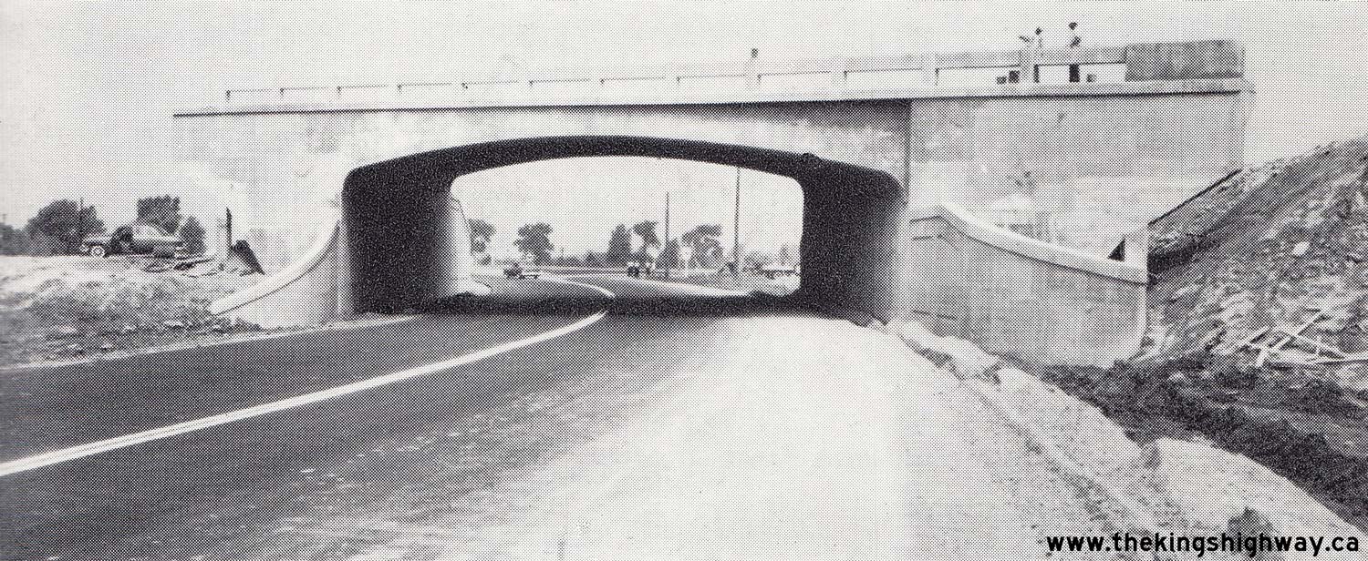
Above - Harry M. Allen, M.P.P. for Middlesex South, cuts a ribbon at the Wellington Road Cloverleaf in London to officially open Hwy 401 to traffic on May 31,
1957. This was the second official opening ceremony for Hwy 401 held that day to mark the completion of the 38-mile section of the highway between London and
Woodstock. In the front row from left to right, the other attendees were: C.E. Janes, M.P.P. for Lambton East; F.S. Thomas, M.P.P. for Elgin; James N. Allan, Minister
of Highways; and finally, James A. McBain, M.P. for Elgin. Photo taken on May 31, 1957. See an
Enlarged Photo Here. (Photo courtesy of Ontario Ministry of Transportation - © King's Printer for Ontario, 1957) 
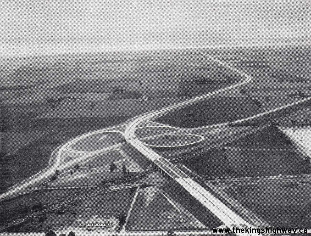
Above - Plan showing the London-Woodstock section of Hwy 401, as it existed on opening day on May 31, 1957. This 38-mile (61 km) section of Hwy 401 was
especially noteworthy, in that it was the longest section of Hwy 401 ever opened to traffic on a single day. As can be seen in this image, Hwy 401 was not constructed
in a linear fashion from Toronto. Rather, sections of Hwy 401 were built and opened independently of one another, based largely on the urgency of the traffic needs on
parallel King's Highways. The London-Woodstock section of Hwy 2 had been overburdened by through traffic for over a decade, as it was the only direct east-west
highway running between Southwestern Ontario and the Toronto and Hamilton areas. Construction of the London-Woodstock section of Hwy 401 was thus considered a
priority section. The first construction contracts got underway in 1952, and the highway was completed 5 years later. The London-Woodstock section of Hwy 401 was not
united with the Toronto section of Hwy 401 until the early 1960s, when the final gap in the highway between Toronto and London was completed and opened to traffic
west of Kitchener on November 9, 1961. See an Enlarged Photo Here. (Photo courtesy of Ontario Ministry of Transportation - © King's Printer for Ontario, 1957) 

Left - Aerial view of the Hwy 19 Cloverleaf on Hwy 401 near Ingersoll, facing east towards Woodstock (1957) (Photo courtesy of Ontario Ministry of Transportation - © King's Printer for Ontario, 1957) Right - Aerial view of the Hwy 59 Cloverleaf on Hwy 401 near Woodstock, facing west towards London (1957) (Photo courtesy of Ontario Ministry of Transportation - © King's Printer for Ontario, 1957) 
Above - Facing west along a newly-opened section of Hwy 401 between Avon Road (today's Putnam Road) and the Hwy 73 Cloverleaf near London. The highway opened
to traffic only four days before this photo was taken. Photo taken on June 3, 1957. (Photo courtesy of Ontario Ministry of Transportation - © King's Printer for Ontario, 1957) 
Above - New DHO patrol yard and maintenance garage at the Hwy 401 & Hwy 74 Interchange near Nilestown. The opening of the London-Woodstock section of
Hwy 401 in 1957 created additional demand for highway maintenance in DHO's District #2 (London District). Photo taken on June 3, 1957. (Photo courtesy of Ontario Ministry of Transportation - © King's Printer for Ontario, 1957) 
Above - New York Central Railway Overhead on Hwy 401 at the Windsor Entrance (1957) (Photo courtesy of Ontario Ministry of Transportation - © King's Printer for Ontario, 1957) 

Left - Summer students setting up a traffic counting station on the eastbound lanes of the Toronto Bypass (Hwy 401) between Dufferin Street and Bathurst
Street in 1957. Traffic counts were conducted using mechanical counting equipment that ran 24 hours a day for an entire week. Combined with roadside
"Origin-Destination" traffic surveys conducted at the various highway interchanges, the DHO was able to determine the travel patterns along the highway. Ultimately,
traffic studies such as these were used in the development of the Express-Collector Lane System along Hwy 401 across Toronto in the 1960s. The crew, from left to
right, are: Gary Smith, Duane Wills, Neal Johnson and Ralph Prentice. See an Enlarged Photo Here. (Photo courtesy of Ontario Ministry of Transportation - © King's Printer for Ontario, 1957) Right - Traffic on Hwy 401 near Hwy 11 (Yonge Street) in July 1957, facing west from the Hogg's Hollow Bridge towards the Hwy 11A (Avenue Road) Cloverleaf. This interesting photo shows the rapidly growing traffic volumes on the four-lane Toronto Bypass, about 5 years after the highway's completion between the western end of the Hogg's Hollow Bridge and Weston Road in 1952. Apart from the astonishingly high traffic volumes, Hwy 401 had an almost park-like boulevard setting at this point, amongst towering trees which overhung the highway in places - certainly a far cry from the 14-lane concrete and asphalt python which Hwy 401 has become today! A narrow curbed median is all that separates the eastbound and westbound carriageways at this point. For many years in fact, Hwy 401 was an undivided highway across the Hogg's Hollow Bridge without any centre divider at all. It is interesting to note that this section of the highway was not illuminated, which was actually typical for the Toronto Bypass during the 1950s. Initially, Hwy 401 was only illuminated at major interchanges across Toronto. The reverse curve seen in this 1957 photo is the same curve which can be found today just east of Avenue Road, where the Express-Collector Transfers are located. See an Enlarged Photo Here. Photo taken on July 12, 1957. (Photo © Archives of Ontario - Series RG-14-151-1, Container A-1674, Photo #300: Hwy 401 traffic at Hwy 11, [photograph], [July 12, 1957], Ministry of Transportation Chronological Numbered Photos, RG-14-151-1, Archives of Ontario, B116125, Copyright Crown) 

Left - Construction progress on the Hwy 27 & Hwy 401 Interchange in Toronto in 1958, facing south along Hwy 27 from the westbound Hwy 401 structure. Note the start of
the divided highway in the distance. The extension of Hwy 401 westerly from Toronto towards Milton resulted in numerous retrofits to the Hwy 27 Interchange, including
the construction of a left-hand exit ramp from eastbound Hwy 401 to northbound Hwy 27. This ramp was closed permanently during reconstruction of this interchange in
1970. Photo taken in 1958. (Photo courtesy of Ontario Ministry of Transportation - © King's Printer for Ontario, 1958) Right - New asphalt pavement and zone striping on an unopened section of Hwy 401 near the Hwy 30 Junction west of Trenton (1958) (Photo courtesy of Ontario Ministry of Transportation - © King's Printer for Ontario, 1958) 

Left - Plan showing the Trenton-Brighton section of Hwy 401, as it existed on opening day on November 25, 1958. This 10-mile (16 km) section of Hwy 401 lying
between the Hwy 30 Junction and the Hwy 33 Interchange was actually the second phase of the Belleville and Trenton Bypass. The section of Hwy 401 lying to the east of
Hwy 33 was the first phase of the bypass, which opened to traffic earlier that fall. (Photo courtesy of Ontario Ministry of Transportation - © King's Printer for Ontario, 1958) Right - Canadian Pacific Railway (CPR) Overhead on Hwy 401 east of the Mill Street Interchange in Newcastle (1958) (Photo courtesy of Ontario Ministry of Transportation - © King's Printer for Ontario, 1958) 
Above - Hope-Clarke Township Boundary Road Overpass on Hwy 401 east of Newcastle (1958) (Photo courtesy of Ontario Ministry of Transportation - © King's Printer for Ontario, 1958) 

Left - Newly-completed Kingston Bypass (Hwy 401) facing east towards the Montreal Street Overpass (1958) (Photo courtesy of Ontario Ministry of Transportation - © King's Printer for Ontario, 1958) Right - DHO engineer inspecting a new 40-foot concrete arch bridge over Dyeworks Creek on a future section of Hwy 401 located west of the proposed Hwy 45 Interchange in Cobourg (1958) (Photo courtesy of Ontario Ministry of Transportation - © King's Printer for Ontario, 1958) 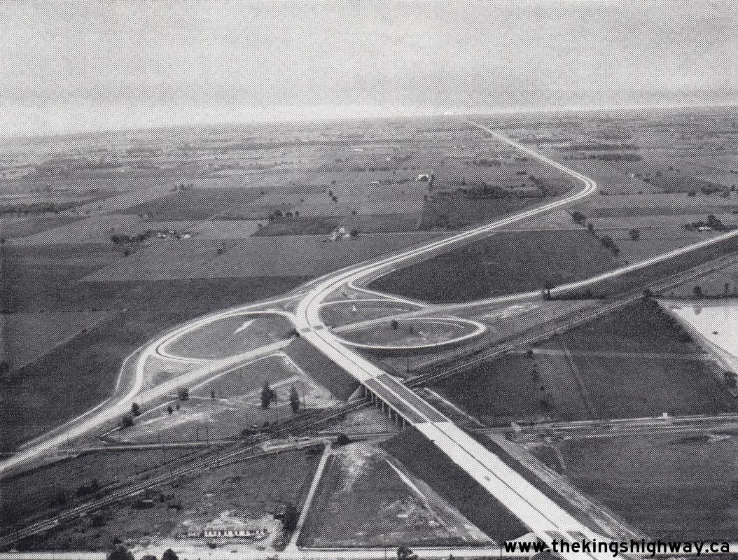

Left - Aerial view of the Hwy 98 (Provincial Road) Interchange on Hwy 401 in Windsor, facing east towards Tilbury. See an
Enlarged Photo Here. Photo taken in 1958. (Photo courtesy of Ontario Ministry of Transportation - © King's Printer for Ontario, 1958) Right - Aerial view of the Windsor High-Speed Interchange at the diverge between the Hwy 401 Tunnel and Bridge Routes in 1958. The Hwy 401 Bridge Route exited left to join Hwy 3 (Huron Church Road) to the Ambassador Bridge, while the Hwy 401 Tunnel Route exited right to join Hwy 3B to the Detroit-Windsor Tunnel. Photo taken in 1958. (Photo courtesy of Ontario Ministry of Transportation - © King's Printer for Ontario, 1958) 
Above - Facing west towards the Windsor High-Speed Interchange on Hwy 401 from the Walker Road Underpass in Windsor (1958) (Photo courtesy of Ontario Ministry of Transportation - © King's Printer for Ontario, 1958) 

Left - Aerial view of Hwy 401 (Tunnel Route) looking east from Howard Avenue (Hwy 3B) in Windsor (1958) (Photo courtesy of Ontario Ministry of Transportation - © King's Printer for Ontario, 1958) Right - Official opening of Hwy 401 from Hwy 98 to Hwy 3 and Hwy 3B in Windsor on June 9, 1958. The official ribbon-cutting ceremony was attended by (from left to right) William Griesinger (M.P.P. for Windsor-Sandwich), H.J. Lassaline (General Manager of Windsor Chamber of Commerce & Secretary of Essex County Tourist Association), G.U. Howell (Chatham DHO District Engineer), W.J. Fulton (Deputy Minister of Highways), Fred M. Cass (Minister of Highways), and William Murdoch (M.P.P. for Essex South). It is important to take note of the changing attitudes towards highways since this photo was taken. The job titles of the participants at this ribbon-cutting ceremony reflect the fact that new highways were once openly recognized and welcomed as both an economic investment and a boon for tourism. Highways create construction and maintenance jobs, stimulate economic development and generally increase surrounding land values, in addition to the obvious benefit of relieving traffic congestion on other parallel routes. At some point in the last 50 years that message seems to have been lost. It is actually quite disheartening to consider that the long awaited (and badly needed) extension of Hwy 410 to Caledon quietly opened to traffic in November 2009, without even so much as a press release from the provincial government, let alone a ribbon-cutting ceremony. As a society, have we forgotten about the indispensable benefits that highways can bring us? (Photo courtesy of Ontario Ministry of Transportation - © King's Printer for Ontario, 1958) 
Above - Aerial view of Hwy 401 facing west from the Provincial Road (Hwy 98) Interchange in Windsor. See an
Enlarged Photo Here. Photo taken in 1958. (Photo courtesy of Ontario Ministry of Transportation - © King's Printer for Ontario, 1958) 
Above - Junction of Hwy 2 & Hwy 401 (Thousand Islands Parkway) near Brockville in 1958, facing west towards Gananoque. For many years, these two highways
joined together at a skewed at-grade intersection. A new bridge and interchange was built near here as part of the new Brockville Bypass section of Hwy 401 in 1959.
Photo taken on August 8, 1958. See an Enlarged Photo Here. (Photo © Archives of Ontario - Series RG-14-151-5-15, Photo #999) 
Above - Hwy 401 and Hwy 11 (Yonge Street) Cloverleaf in Toronto, facing north towards Richmond Hill in 1958. When the Yonge Street Interchange was first
completed on Hwy 401 in 1953, it was a full eight-ramp cloverleaf. This interchange was completely reconfigured when this section of Hwy 401 was widened in 1966-1967.
The full cloverleaf interchange seen here was replaced by a partial cloverleaf interchange with a directional ramp to serve the heavy eastbound Hwy 401 to northbound
Hwy 11 movement. Note the Toronto Transit Commission (TTC) bus loop situated within the cloverleaf interchange. (Photo courtesy of Ontario Ministry of Transportation - © King's Printer for Ontario, 1958) 

Left - Concrete paving operations on Hwy 401 west of the Hwy 10 Cloverleaf between Toronto and Streetsville (1958) (Photo courtesy of Ontario Ministry of Transportation - © King's Printer for Ontario, 1958) Right - Sixteen Mile Creek Bridge on Hwy 401 between Milton and Campbellville (1959) (Photo courtesy of Ontario Ministry of Transportation - © King's Printer for Ontario, 1959) 
Above - Aerial view of the Hwy 401 and Hwy 11 (Yonge Street) Cloverleaf in Toronto, facing south in 1959. This aerial photo of the Yonge Street Interchange at
rush hour clearly demonstrates the problem with this interchange design when traffic volumes are heavy and the opposing loop ramps are placed too close together. A
red traffic signal on Yonge Street north of Hwy 401 has caused northbound traffic to queue right through the cloverleaf interchange and onto the eastbound loop ramp
exiting from the freeway. The queue has also blocked access to the opposing loop ramp from northbound Hwy 11 to westbound Hwy 401. When the interchange was rebuilt
in 1966-1967, a two-lane directional ramp was constructed to remove the bottleneck caused by the heavy eastbound Hwy 401 to northbound Hwy 11 movement. (Photo courtesy of Ontario Ministry of Transportation - © King's Printer for Ontario, 1959) 
Above - New grade separation on Hwy 401 at Westminster Drive near London, 2 miles west of Wellington Road (1959) (Photo courtesy of Ontario Ministry of Transportation - © King's Printer for Ontario, 1959) 
Above - Guelph Junction Canadian Pacific Railway (CPR) Overhead on Hwy 401 between Campbellville and Morriston (1959) (Photo courtesy of Ontario Ministry of Transportation - © King's Printer for Ontario, 1959) 
Above - Campbell Avenue Underpass on Hwy 401 at Campbellville, west of Milton (1959) (Photo courtesy of Ontario Ministry of Transportation - © King's Printer for Ontario, 1959) 

Left - Aerial view of a traffic jam on Hwy 401 in Toronto, facing west towards the Hwy 27 Interchange. Photo taken on June 17, 1959. See an
Enlarged Photo Here. (Photo © Archives of Ontario - Series RG-14-151-5-26, Box B1106, Photo #ES12-712) Right - Aerial view of a traffic jam on Hwy 401, facing northeast from the Hwy 27 Interchange in Toronto in 1959. The bizarre ramp configuration of the Hwy 27 and Hwy 401 Interchange is clearly visible in this photo. The ramp from eastbound Hwy 401 to northbound Hwy 27 was originally a left-hand exit. This ramp also had a direct merge onto northbound Hwy 27 with no acceleration lane, suggesting that this ramp connection was an afterthought conceived very late in the planning phase after the westbound Hwy 401 structure had been built. Beyond the westbound Hwy 401 structure, a direct taper loop ramp exited from northbound Hwy 27 to westbound Hwy 401. This unorthodox interchange existed up until the early 1970s, when the Hwy 27 Interchange was removed in order to accommodate the new freeway connection to Hwy 427. Photo taken on June 17, 1959. See an Enlarged Photo Here. (Photo © Archives of Ontario - Series RG-14-151-5-26, Box B1106, Photo #ES12-711) 
Above - Traffic jam on Hwy 401 at Keele Street, facing east towards Dufferin Street in 1959. Note that in this photo, an additional eastbound lane was added
to Hwy 401 through the Keele Street Interchange. The 1958 photo taken from the Keele Street Overpass above only shows two eastbound lanes on Hwy 401 through the
interchange. The extra lane was intended to provide a refuge for slow trucks as they ascended the long uphill grade on eastbound Hwy 401 between Hwy 400 and Dufferin
Street. Photo taken in June, 1959. See an Enlarged Photo Here. (Photo © Archives of Ontario - Series RG-14-151-5-26, Box B1106, Photo #ES12-700) 
Above - Hwy 401 at the Hwy 11A (Avenue Road) Cloverleaf in Toronto, looking east (1959) (Photo courtesy of Ontario Ministry of Transportation - © King's Printer for Ontario, 1959) 

Left - CP Railway Underpass on Hwy 401 between Weston Road and Hwy 400 in Toronto (1959) (Photo courtesy of Ontario Ministry of Transportation - © King's Printer for Ontario, 2011) Right - Grading progress on Hwy 401 at Tremaine Road, facing east towards Milton (1959) (Photo courtesy of Ontario Ministry of Transportation - © King's Printer for Ontario, 1959) 
Above - Hwy 401 and Hwy 27 Interchange, facing north along Hwy 27 from the Richview Sideroad Overpass in 1959. This photo provides an interesting view of the
Hwy 27 Freeway as it approaches the Hwy 401 Interchange in Toronto. Due to the complex exit ramp configuration at this interchange, a large overhead sign structure
was placed above the highway to guide traffic. At the time this sign structure was installed in 1958, it was the largest of its kind in the province. Photo taken on
November 12, 1959. See an Enlarged Photo Here. (Photo © Archives of Ontario - Series RG-14-162-2-27, Box B983, Photo #1169C) 
Above - Plan showing the new section of Hwy 401 from the Hwy 10 Cloverleaf in Toronto Township to the Hwy 25 Cloverleaf in Milton, as it existed on opening day
on November 26, 1959. On opening day, the only intermediate interchanges along this section of Hwy 401 were located at Streetsville (Mississauga Road) and 7th Line
(Trafalgar Road). Since the 1980s, interchanges have also been built at Mavis Road, Winston Churchill Boulevard and James Snow Parkway. (Photo courtesy of Ontario Ministry of Transportation - © King's Printer for Ontario, 1959)
Continue on to King's Highway 401 Photos: Historical Photos (1960-1964)
|
|---|
Links to Adjacent King's Highway Photograph Pages:
Back to Hwy 401 - Historical Photos (1938-1954)
Hwy 401 Photo Index
On to Hwy 401 - Historical Photos (1960-1964)
Back to King's Highway 400 Photos /
King's Highway 401 History /
On to King's Highway 402 Photos
Ontario Highway History - Main Menu / Back to List of Highways Website contents, photos & text © 2002-2026, Cameron
Bevers (Webmaster) - All Rights Reserved / Contact Me
|
|---|