
| 
| |
|
|
This page contains historical photos of Ontario's King's Highway 401 dating from 1960 to 1964. All photographs displayed on
this page were taken by the Ontario Ministry of Transportation, unless specifically noted otherwise. Historical photographs are arranged in approximate chronological
order. Click on any thumbnail to see a larger image!
Please note that all photographs displayed on this
website are protected by copyright. These photographs must not be reproduced, published,
electronically stored or copied, distributed, or posted onto other websites without
my written permission. If you want to use photos from this website, please
email me first for permission. Thank-you!
|
|---|
|
Page 3: Historical King's Highway 401 Photographs (1960 to 1964)


Left - View of the Hwy 401 & Hwy 11A (Avenue Road) Cloverleaf in Toronto after a winter snowstorm in 1960. See an
Enlarged Photo Here. Photo taken on February 26, 1960. (Photo courtesy of Ontario Ministry of Transportation - © King's Printer for Ontario, 1960) Right - Traffic on the newly-opened Port Hope Bypass section of Hwy 401 west of the Hwy 28 Interchange in 1960. An interesting feature of the Port Hope Bypass is that the eastbound and westbound lanes of the highway were built at different elevations near the Ganaraska River Bridge. The eastbound lanes at this point are about 20 feet higher in elevation than the westbound lanes. In August 1959, a grading and paving contract (Contract #1959-200) was awarded by the Department of Highways of Ontario (DHO) for the construction of the 2 1/4-mile Port Hope Bypass between the Hwy 2 Interchange and the Hwy 28 Interchange. See an Enlarged Photo Here. Photo taken in 1960. (Photo courtesy of Ontario Ministry of Transportation - © King's Printer for Ontario, 1960) 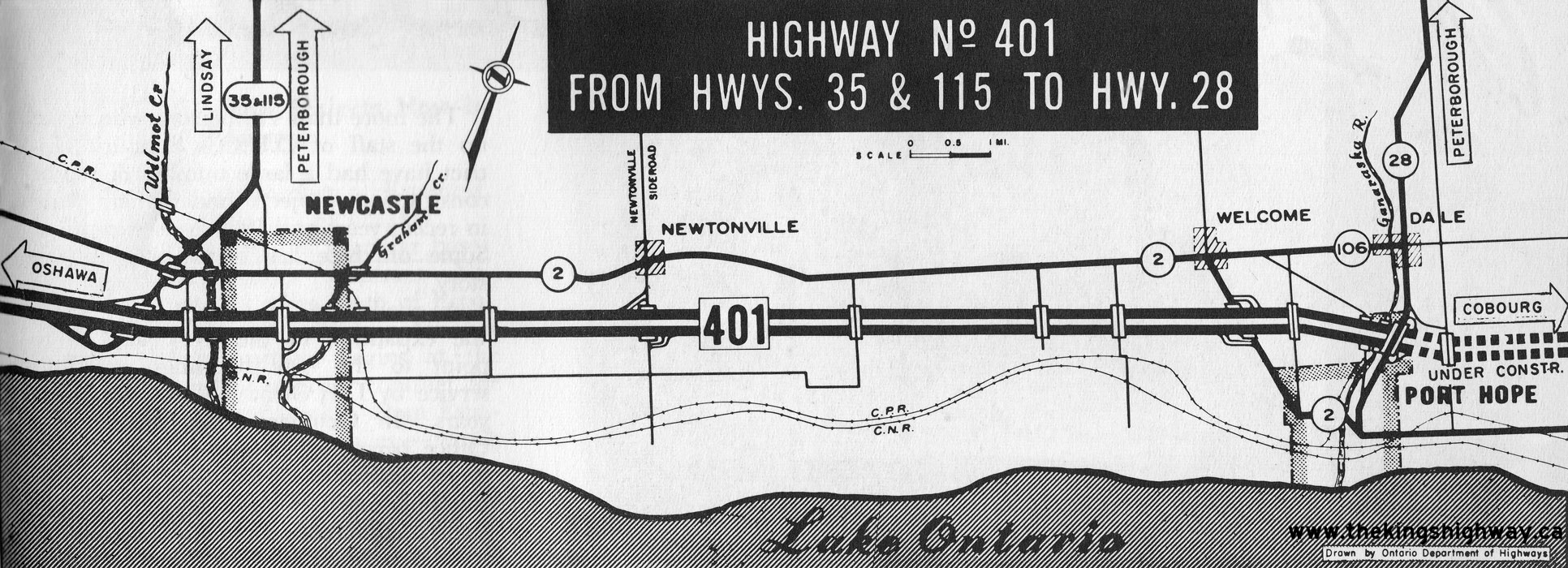
Above - Plan from 1960 which illustrates a new section of Hwy 401 being opened to traffic between Newcastle and Port Hope. The 18-mile extension of Hwy 401
from the Hwy 35 & Hwy 115 Interchange easterly to the Hwy 28 Interchange was officially opened to traffic on June 30, 1960. The cost of the Hwy 401 extension from
Newcastle to Port Hope was about $8.9 million (in 1960 Dollars) including property acquisition, the equivalent of about $91 million in 2024 Dollars. See an
Enlarged Photo Here. Plan dated 1960. (Photo courtesy of Ontario Ministry of Transportation - © King's Printer for Ontario, 1960) 
Above - Grading operations on the Tilbury Bypass section of Hwy 401, Contract #1959-332. In January 1960, a construction contract was awarded for grading,
granular base and hot-mix asphalt paving on the proposed 4 1/2-mile Tilbury Bypass. The bypass was opened to traffic in the Fall of 1961, after two construction
seasons. See an Enlarged Photo Here. Photo taken in 1960. (Photo courtesy of Ontario Ministry of Transportation - © King's Printer for Ontario, 1960) 
Above - View of Hwy 401 at the Mississauga Road Interchange near Streetsville. The Mississauga Road Overpass was constructed under Contract #1958-91. The
Streetsville Interchange was one of only two intermediate interchanges constructed along Hwy 401 during the 1950s between the two cloverleaves situated at Hwy 10
(Hurontario Street) and Hwy 25 in Milton. The only other original interchange located along this section of Hwy 401 was located at 7th Line (Trafalgar Road). In
wasn't until the 1980s that other new interchanges began to appear along Hwy 401 between Mississauga and Milton. See an
Enlarged Photo Here. Photo taken in 1960. (Photo courtesy of Ontario Ministry of Transportation - © King's Printer for Ontario, 1960) 
Above - View of the Hwy 25 Cloverleaf on Hwy 401 in Milton, facing east towards Toronto. The construction of the cloverleaf interchange at Hwy 25 along with
the overpass structure were built under Contract #1958-660. Until Hwy 401 was extended westerly to Kitchener and Preston, only the east-oriented ramps at this
cloverleaf were put into service. The west-oriented ramps at the Hwy 25 Cloverleaf were opened to traffic in 1960, along with the westerly extension of Hwy 401 from
Milton to Preston. See an Enlarged Photo Here. Photo taken in 1960. (Photo courtesy of Ontario Ministry of Transportation - © King's Printer for Ontario, 1960) 
Above - Plan from 1960 which illustrates the completion of all four lanes of the Brockville Bypass section of Hwy 401. This section of Hwy 401 between the
Hwy 2 Interchange west of Brockville and the Edward Street Interchange in Prescott was initially opened to traffic as a two-lane highway on November 13, 1959. All
traffic used the south (eastbound) carriageway until the north (westbound) carriageway was completed about 10 months later. The north carriageway between Brockville
and Prescott was opened to traffic without any official opening ceremony on September 16, 1960, after which time the existing south carriageway was converted to carry
eastbound Hwy 401 traffic only. See an Enlarged Photo Here. Plan dated 1960. (Photo courtesy of Ontario Ministry of Transportation - © King's Printer for Ontario, 1960) 

Left - Flush median on the Humber River Bridge in Toronto. This bridge near Weston Road was originally designed to carry two lanes per direction on Hwy 401.
During the 1960s, the construction of the Express-Collector Lane System on Hwy 401 through Toronto necessitated the widening of the Humber River Bridge from 4 through
lanes to 12 through lanes. See an Enlarged Photo Here. Photo taken in October 1960. (Photo courtesy of Ontario Ministry of Transportation - © King's Printer for Ontario, 2011)  Right - View of the Brockville Bypass (Hwy 401) facing west towards Kingston from the Hwy 29 & Hwy 42 (Stewart Boulevard) Interchange in Brockville in
1960. This photo was taken shortly after the north (westbound) carriageway of Hwy 401 was completed and opened to traffic on September 16, 1960. Previously, both
directions of traffic used the south (eastbound) carriageway. See an Enlarged Photo Here.
Photo taken in 1960. Right - View of the Brockville Bypass (Hwy 401) facing west towards Kingston from the Hwy 29 & Hwy 42 (Stewart Boulevard) Interchange in Brockville in
1960. This photo was taken shortly after the north (westbound) carriageway of Hwy 401 was completed and opened to traffic on September 16, 1960. Previously, both
directions of traffic used the south (eastbound) carriageway. See an Enlarged Photo Here.
Photo taken in 1960.(Photo courtesy of Ontario Ministry of Transportation - © King's Printer for Ontario, 1960) 
Above - Plan from 1960 which illustrates a new section of Hwy 401 being opened to traffic between the Hwy 25 Cloverleaf in Milton and the Hwy 8 Cloverleaf in
Preston. This 26-mile extension of Hwy 401 was officially opened to traffic on November 17, 1960. The estimated construction cost of the Milton-Preston extension of
Hwy 401 was $13.3 Million (in 1960 Dollars) the equivalent of about $136.5 Million in 2024 Dollars. On opening day, the only intermediate interchanges along this
section of Hwy 401 were located at Campbellville (Guelph Line), Hwy 6 (to Guelph & Hamilton) and Hwy 24 (to Galt & Hespeler). Since 1960, interchanges have
also been built along Hwy 401 at the Hanlon Parkway (Hwy 6 New, to Guelph), as well as Franklin Boulevard, Townline Road, and the Hwy 8 Bypass in the Cambridge area.
See an Enlarged Photo Here. Plan dated 1960. (Photo courtesy of Ontario Ministry of Transportation - © King's Printer for Ontario, 1960) 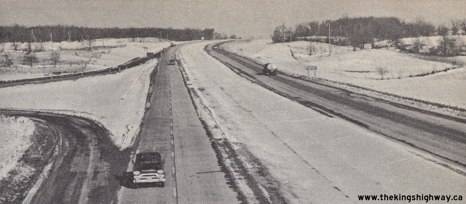 Above - Facing east along Hwy 401 towards Milton from the Hwy 6 Interchange, shortly after being opened to traffic in November 1960. See an
Enlarged Photo Here. Photo taken in 1960. Above - Facing east along Hwy 401 towards Milton from the Hwy 6 Interchange, shortly after being opened to traffic in November 1960. See an
Enlarged Photo Here. Photo taken in 1960.(Photo courtesy of Ontario Ministry of Transportation - © King's Printer for Ontario, 1960) 

Left - Facing west along Hwy 401 approaching the Nassagaweya First Line Overpass located between the Guelph Line Interchange at Campbellville and the
Wellington-Halton County Boundary east of the Hwy 6 Interchange. The Nassagaweya First Line Overpass was constructed under Contract #1959-21. See an
Enlarged Photo Here. Photo taken on April 28, 1961. (Photo courtesy of Ontario Ministry of Transportation - © King's Printer for Ontario, 2023) Right - View of the Nassagaweya First Line Overpass on Hwy 401 west of Campbellville. See an Enlarged Photo Here. Photo taken on April 28, 1961. (Photo courtesy of Ontario Ministry of Transportation - © King's Printer for Ontario, 2023) 

Left - Approaching the Guelph Junction Canadian Pacific Railway (CPR) Overhead on Hwy 401, east of the Hwy 6 Interchange. See an
Enlarged Photo Here. Photo taken on April 28, 1961. (Photo courtesy of Ontario Ministry of Transportation - © King's Printer for Ontario, 2014) Right - Northern side of the Guelph Junction CPR Overhead on Hwy 401 east of the Hwy 6 Interchange, built under Contract #1958-87. See an Enlarged Photo Here. Photo taken on April 28, 1961. (Photo courtesy of Ontario Ministry of Transportation - © King's Printer for Ontario, 2014) 

Left - Facing east along Hwy 401 towards Milton approaching the Guelph Line Interchange at Campbellville. The Guelph Line Overpass was constructed under
Contract #1959-32. See an Enlarged Photo Here. Photo taken on April 28, 1961. (Photo courtesy of Ontario Ministry of Transportation - © King's Printer for Ontario, 2023) Right - View of the Guelph Line Overpass on Hwy 401 at Campbellville, facing north towards Rockwood. See an Enlarged Photo Here. Photo taken on April 28, 1961. (Photo courtesy of Ontario Ministry of Transportation - © King's Printer for Ontario, 2023) 

Left - Facing west along Hwy 401 towards the Guelph Line Interchange at the Campbellville Road Underpass. See an
Enlarged Photo Here. Photo taken on April 28, 1961. (Photo courtesy of Ontario Ministry of Transportation - © King's Printer for Ontario, 2023) Right - Campbellville Road (today's Campbell Avenue) Underpass on Hwy 401 west of Milton, built under Contract #1958-635. See an Enlarged Photo Here. Photo taken on April 28, 1961. (Photo courtesy of Ontario Ministry of Transportation - © King's Printer for Ontario, 2023) 

Left - Facing east along Hwy 401 towards Milton at the Oakville Creek Bridge east of Campbellville. See an
Enlarged Photo Here. Photo taken on April 28, 1961. (Photo courtesy of Ontario Ministry of Transportation - © King's Printer for Ontario, 2023) Right - Oakville Creek Bridge on Hwy 401 west of Milton. The Oakville Creek Bridge was constructed under Contract #1958-187. See an Enlarged Photo Here. Photo taken on April 28, 1961. (Photo courtesy of Ontario Ministry of Transportation - © King's Printer for Ontario, 2023) 

Left - Facing east along Hwy 401 towards Milton at the Halton County Road 8 (Appleby Line) Underpass. See an
Enlarged Photo Here. Photo taken on April 28, 1961. (Photo courtesy of Ontario Ministry of Transportation - © King's Printer for Ontario, 2023) Right - Halton County Road 8 Underpass at Appleby Line on Hwy 401 west of Milton, constructed under Contract #1958-201. See an Enlarged Photo Here. Photo taken on April 28, 1961. (Photo courtesy of Ontario Ministry of Transportation - © King's Printer for Ontario, 2023) 

Left - View of Hwy 401 approaching Tremaine Road in 1961, facing east towards Milton. This interesting photo shows the newly-completed (and virtually empty)
highway between Milton and Kitchener, which had only been open to traffic for about 5 months at the time this photo was taken. The section of Hwy 401 from the Hwy 25
Interchange in Milton to the Hwy 8 Interchange between Preston and Kitchener was completed and officially opened to traffic on November 17, 1960. Since Hwy 401 came
to an end at Hwy 8, it really didn't attract much through traffic until the Woodstock-Preston section of Hwy 401 was completed in late 1961. During its first year of
operation, the section of Hwy 401 west of Milton only carried about 7,500 vehicles per day. By comparison, this same section of Hwy 401 carried over 120,000 vehicles
per day in 2021. See an Enlarged Photo Here. Photo taken on April 28, 1961. (Photo courtesy of Ontario Ministry of Transportation - © King's Printer for Ontario, 2014) Right - Facing north across the Tremaine Road Overpass on Hwy 401 west of Milton, constructed under Contract #1959-20. See an Enlarged Photo Here. Photo taken on April 28, 1961. (Photo courtesy of Ontario Ministry of Transportation - © King's Printer for Ontario, 2014) 

Left - Hwy 25 Cloverleaf on Hwy 401 in Milton, facing east towards Toronto. See an
Enlarged Photo Here. Photo taken on April 28, 1961. (Photo courtesy of Ontario Ministry of Transportation - © King's Printer for Ontario, 2011) Right - Facing north across the Hwy 25 Overpass on Hwy 401 in Milton. See an Enlarged Photo Here. Photo taken on April 28, 1961. (Photo courtesy of Ontario Ministry of Transportation - © King's Printer for Ontario, 2011)  Above - Girder erection for the twin Harwood Avenue Overpass in Ajax, Contract #1960-275. Due to growing traffic congestion across the original 1941 Harwood
Avenue Overpass, a new twin structure was built in 1961 to carry the northbound lanes of Harwood Avenue. Following the completion of the new northbound structure, the
old bridge was converted to carry southbound traffic only. Rather than attempt to construct a cast-in-place twin concrete rigid frame bridge, it was decided to
utilize precast concrete girders instead. A total of 14 pre-stressed concrete girders were manufactured and trucked out to the site. Each girder was 54 feet in length
and weighed 44,000 pounds. During construction, traffic on Hwy 401 was briefly reduced to one lane per direction for a period of 20 minutes by means of median
crossover diversions, which allowed the girder hoisting to take place over the closed lanes on one side of the highway. Once each girder was secured to the abutments
and centre pier, all four lanes of Hwy 401 were reopened to traffic until the next girder was delivered and ready to be hoisted into place. See an
Enlarged Photo Here. Photo taken in 1961. Above - Girder erection for the twin Harwood Avenue Overpass in Ajax, Contract #1960-275. Due to growing traffic congestion across the original 1941 Harwood
Avenue Overpass, a new twin structure was built in 1961 to carry the northbound lanes of Harwood Avenue. Following the completion of the new northbound structure, the
old bridge was converted to carry southbound traffic only. Rather than attempt to construct a cast-in-place twin concrete rigid frame bridge, it was decided to
utilize precast concrete girders instead. A total of 14 pre-stressed concrete girders were manufactured and trucked out to the site. Each girder was 54 feet in length
and weighed 44,000 pounds. During construction, traffic on Hwy 401 was briefly reduced to one lane per direction for a period of 20 minutes by means of median
crossover diversions, which allowed the girder hoisting to take place over the closed lanes on one side of the highway. Once each girder was secured to the abutments
and centre pier, all four lanes of Hwy 401 were reopened to traffic until the next girder was delivered and ready to be hoisted into place. See an
Enlarged Photo Here. Photo taken in 1961.(Photo courtesy of Ontario Ministry of Transportation - © King's Printer for Ontario, 1961) 

Left - Facing north across the Hope-Clark Township Boundary Road (East Townline Road) Overpass west of Port Hope in 1961. This structure was originally built
in 1958, under Contract #1958-48. Although the vertical clearance below this structure exceeded 4.5 metres, the bridge had the misfortune of being struck by
over-height vehicles several times during its existence. The bridge suffered a fatal blow on October 7, 2013, when a westbound flatbed cargo truck carrying an
over-height load collided with the side of the bridge. The bridge was severely damaged as a result of the collision, and was immediately closed to northbound and
southbound traffic. Despite the collision, the structure was already scheduled for replacement. The East Townline Road Overpass was demolished on March 22, 2014. A
new structure was completed here in 2015. See an Enlarged Photo Here. Photo taken on June
2, 1961. (Photo courtesy of Ontario Ministry of Transportation - © King's Printer for Ontario, 2014) Right - Facing west along Hwy 401 towards Newcastle near the Clarke-Hope Township Boundary Road (East Townline Road) Overpass in 1961. This photo shows a newly-completed section of Hwy 401 between Newcastle and Port Hope, which had opened to traffic less than a year before this photo was taken. Ever since the late 1930s, highway engineers had envisioned building a superhighway from Toronto to the Quebec Boundary. As various sections of Hwy 401 were completed through Eastern Ontario in the early 1960s, that dream quickly moved towards becoming a reality. The dream was realized (at least partially) when the 9-mile section of Hwy 401 was completed and opened to traffic between Lancaster and the Quebec Boundary on November 10, 1964. Although Hwy 401 had been extended to the Quebec Boundary, the highway was by no means complete. Many sections of the highway were still only two lanes with at-grade intersections and railway crossings. In fact, the permanent controlled-access route of Hwy 401 between Gananoque and Brockville was still on engineers' drawing boards in 1964. It wasn't until 1968 that the final four-lane section of Hwy 401 was completed and opened to traffic west of Brockville. See an Enlarged Photo Here. Photo taken on June 2, 1961. (Photo courtesy of Ontario Ministry of Transportation - © King's Printer for Ontario, 2014) 

Left - Facing west towards Henry Street from the Hwy 12 Interchange on Hwy 401 in Whitby. See an
Enlarged Photo Here. Photo taken in June 1961. (Photo courtesy of Ontario Ministry of Transportation - © King's Printer for Ontario, 2011) Right - Facing north across the Henry Street Overpass on Hwy 401 in Whitby. See an Enlarged Photo Here. Photo taken in June 1961. (Photo courtesy of Ontario Ministry of Transportation - © King's Printer for Ontario, 2011) 

Left - Approaching the Simcoe Street Interchange on Hwy 401 in Oshawa, facing east. See an
Enlarged Photo Here. Photo taken in June 1961. (Photo courtesy of Ontario Ministry of Transportation - © King's Printer for Ontario, 2011) Right - Concrete arch bridge on Hwy 401 over Oshawa Creek, near the Simcoe Street Interchange in Oshawa. See an Enlarged Photo Here. Photo taken in June 1961. (Photo courtesy of Ontario Ministry of Transportation - © King's Printer for Ontario, 2011) 
 Left - Facing west towards Toronto along Hwy 401 from the Simcoe Street Interchange in Oshawa. This colour photo of Hwy 401 shows a portion of the highway
through Oshawa shortly after resurfacing was completed under Contract #1959-215. The original concrete highway pavement laid between Whitby and Oshawa in the
mid-1940s was resurfaced with a hot-mix asphalt pavement, in order to create a composite pavement structure. Resurfacing work began in the Fall of 1959 and was
completed during the Summer of 1960. At the time this photo was taken, the ramps at the Simcoe Street Interchange were still in their original "Parclo A-B"
configuration, which offered access both to and from the east. These east-oriented inner loop ramps were removed in the late 1970s when Hwy 401 was widened from four
to six lanes. See an Enlarged Photo Here. Photo taken in 1961. Left - Facing west towards Toronto along Hwy 401 from the Simcoe Street Interchange in Oshawa. This colour photo of Hwy 401 shows a portion of the highway
through Oshawa shortly after resurfacing was completed under Contract #1959-215. The original concrete highway pavement laid between Whitby and Oshawa in the
mid-1940s was resurfaced with a hot-mix asphalt pavement, in order to create a composite pavement structure. Resurfacing work began in the Fall of 1959 and was
completed during the Summer of 1960. At the time this photo was taken, the ramps at the Simcoe Street Interchange were still in their original "Parclo A-B"
configuration, which offered access both to and from the east. These east-oriented inner loop ramps were removed in the late 1970s when Hwy 401 was widened from four
to six lanes. See an Enlarged Photo Here. Photo taken in 1961.(Photo © Archives of Ontario - Series RG-65-35, Photo #I-0016472) Right - Aerial view of the Hwy 48 (Markham Road) Cloverleaf on Hwy 401 in Scarborough, facing east. See an Enlarged Photo Here. Photo taken in June 1961. (Photo © Archives of Ontario - Series RG-14-151-5-17 Neg. #1328) 

Left - Hwy 401 at the Woodbine Avenue Interchange (now Don Valley Parkway & Hwy 404) in 1961, facing northwest. This great aerial photo shows the layout of
the Hwy 401 & Woodbine Avenue Interchange prior to the construction of the northernmost part of the Don Valley Parkway in the late 1960s. In 1966-1967, this small
four-ramp partial cloverleaf interchange was replaced with the complex interchange that we are familiar with today. During the 1970s, the remainder of Woodbine Avenue
from Sheppard Avenue northerly to Steeles Avenue was reconstructed as Hwy 404. See an
Enlarged Photo Here. Photo taken in June 1961. (Photo © of Archives of Ontario - Series RG-14-151-5-16, Box B1104, Neg. #1344) Right - Hwy 401 at the McCowan Road Overpass in Scarborough in 1961, facing northwest. Anyone familiar with suburban Scarborough today will undoubtedly be shocked by this rather rural aerial photo from 1961. The photo shows the McCowan Road Overpass at Hwy 401, prior to the construction of the Express-Collector Lane System in the early 1970s. Until 1971, there was no interchange at McCowan Road. Traffic had to use either the Kennedy Road or Hwy 48 (Markham Road) Interchanges to access Hwy 401 from McCowan Road. Note the television station on the northwest corner of the overpass, which is still there today. See an Enlarged Photo Here. Photo taken in June 1961. (Photo © Archives of Ontario - Series RG-14-151-5-17, Box B1104, Neg. #1338) 

Left - New Grand River Bridge on Hwy 401 south of Kitchener, constructed under Contract #1959-285. See an
Enlarged Photo Here. Photo taken in 1961. (Photo courtesy of Ontario Ministry of Transportation - © King's Printer for Ontario, 1961) Right - Facing east across the Bloor Street Overpass on Hwy 401 in Oshawa. See an Enlarged Photo Here. Photo taken on June 13, 1961. (Photo courtesy of Ontario Ministry of Transportation - © King's Printer for Ontario, 2012) 

Left - Facing north across the Harwood Avenue Overpass on Hwy 401 in Ajax in 1961, shortly before being converted to a one-way street. During 1961, the Harwood
Avenue structure was twinned in order to provide a new roadway for northbound traffic. The original 1941 structure was converted so that it carried southbound Harwood
Avenue traffic only. Note the unusual flat-metal guide rail installation approaching the bridge, which likely dates from the interchange's original construction in
the early 1940s and the concrete barrier at left which separates the roadway from the bridge's western sidewalk. See an
Enlarged Photo Here. Photo taken on June 15, 1961. (Photo courtesy of Ontario Ministry of Transportation - © King's Printer for Ontario, 2012) Right - Hwy 401 at the Harwood Avenue Interchange between Toronto and Oshawa in 1961. At the time this photo was taken, the twin Harwood Avenue span was still under construction on the eastern side of the existing 1941 structure depicted here. Apart from the addition of an extra lane in each direction on Hwy 401 in the mid-1970s, the Harwood Avenue Interchange remained more or less unmodified until 2003, when the interchange was permanently closed and the old dual overpasses were replaced. See an Enlarged Photo Here. Photo taken on June 15, 1961. (Photo courtesy of Ontario Ministry of Transportation - © King's Printer for Ontario, 2012) 

Left - Approaching the Newcastle Canadian Pacific Railway (CPR) Overhead on Hwy 401, east of the Mill Street Interchange. See an
Enlarged Photo Here. Photo taken in June 1961. (Photo courtesy of Ontario Ministry of Transportation - © King's Printer for Ontario, 2014) Right - Northern side of the Newcastle CPR Overhead on Hwy 401, constructed under Contract #1957-254. See an Enlarged Photo Here. Photo taken in June 1961. (Photo courtesy of Ontario Ministry of Transportation - © King's Printer for Ontario, 2014) 

Left - A southbound train passes below Hwy 401 at the Newcastle CPR Overhead. A handful of at-grade railway crossings existed on Hwy 401 between Toronto and
Bowmanville for many years after the highway was first opened to traffic in the late 1940s and early 1950s. Most of these at-grade crossings were low-volume railway
spurs which didn't carry much rail traffic. However, as the highway became busier, these at-grade railway crossings triggered significant traffic queuing anytime a
train passed through. The last at-grade railway crossing on Hwy 401 was finally removed in 1982, when a new railway subway was built west of Liberty Street in
Bowmanville. See an Enlarged Photo Here. Photo taken in June 1961. (Photo courtesy of Ontario Ministry of Transportation - © King's Printer for Ontario, 2014) Right - Facing east along Hwy 401 towards Bloor Street from Wilson Road in Oshawa. See an Enlarged Photo Here. Photo taken in July 1961. (Photo courtesy of Ontario Ministry of Transportation - © King's Printer for Ontario, 2014) 
Above - Plan from 1961 which illustrates a new section of Hwy 401 being opened to traffic between the Hwy 28 Interchange in Port Hope and the Hwy 30
Interchange near Brighton. This 28-mile extension of Hwy 401 provided a link between the previously-completed Brighton, Trenton and Belleville section of Hwy 401 and
the Toronto-Port Hope section of Hwy 401. The Port Hope-Brighton section of Hwy 401 was officially opened to traffic on July 20, 1961. See an
Enlarged Photo Here. Plan dated 1961. (Photo courtesy of Ontario Ministry of Transportation - © King's Printer for Ontario, 1961) 

Left - Approaching the Cobbledick Road Overpass on Hwy 401 west of Newcastle. See an
Enlarged Photo Here. Photo taken in July 1961. (Photo courtesy of Ontario Ministry of Transportation - © King's Printer for Ontario, 2014) Right - Facing north across the Cobbledick Road Overpass on Hwy 401 west of Newcastle, constructed under Contract #1958-238. See an Enlarged Photo Here. Photo taken in July 1961. (Photo courtesy of Ontario Ministry of Transportation - © King's Printer for Ontario, 2014) 

Left - Facing west along Hwy 401 from the Liberty Street Interchange in Bowmanville. Note the at-grade railway crossing in the background and the early MUTCD
circular railway crossing warning signs on both sides of the westbound lanes of the highway. Until 1982, a CN Railway spur crossed Hwy 401 just west of the Liberty
Street Interchange. When Hwy 401 was widened from four to six lanes in the early 1980s, this at-grade railway crossing was removed and the spur line was relocated
onto a new grade-separated crossing closer to Waverley Road. See an
Enlarged Photo Here. Photo taken in July 1961. (Photo courtesy of Ontario Ministry of Transportation - © King's Printer for Ontario, 2017) Right - Soper Creek Bridge on Hwy 401, facing west towards the Liberty Street Interchange in Bowmanville. See an Enlarged Photo Here. Photo taken in July 1961. (Photo courtesy of Ontario Ministry of Transportation - © King's Printer for Ontario, 2017) 

Left - Facing north across the Mill Street Overpass on Hwy 401 towards Newcastle. See an
Enlarged Photo Here. Photo taken in July 1961. (Photo courtesy of Ontario Ministry of Transportation - © King's Printer for Ontario, 2017) Right - Approaching the Mill Street Interchange on Hwy 401, facing west towards Oshawa. This photo shows the recently-completed section of Hwy 401 between Newcastle and Port Hope, which opened to traffic about a year earlier, on June 30, 1960. The Mill Street Overpass and Interchange were both constructed under Contract #1958-151. See an Enlarged Photo Here. Photo taken in July 1961. (Photo courtesy of Ontario Ministry of Transportation - © King's Printer for Ontario, 2017) 
Above - Plan from 1961 which illustrates a new section of Hwy 401 being opened to traffic between the Hwy 16 Cloverleaf near Johnstown and Brinston Road near
Iroquois. This 10-mile extension of Hwy 401 was officially opened to traffic on September 29, 1961. It complemented earlier sections of Hwy 401 completed between the
Iroquois area and Morrisburg area along with the Prescott Bypass, which were completed in 1957 and 1952, respectively. See an
Enlarged Photo Here. Plan dated 1961. (Photo courtesy of Ontario Ministry of Transportation - © King's Printer for Ontario, 1961) 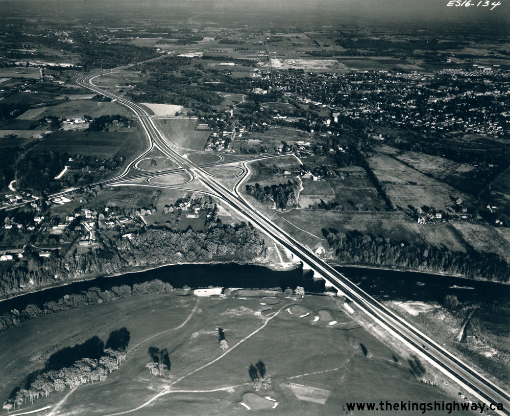
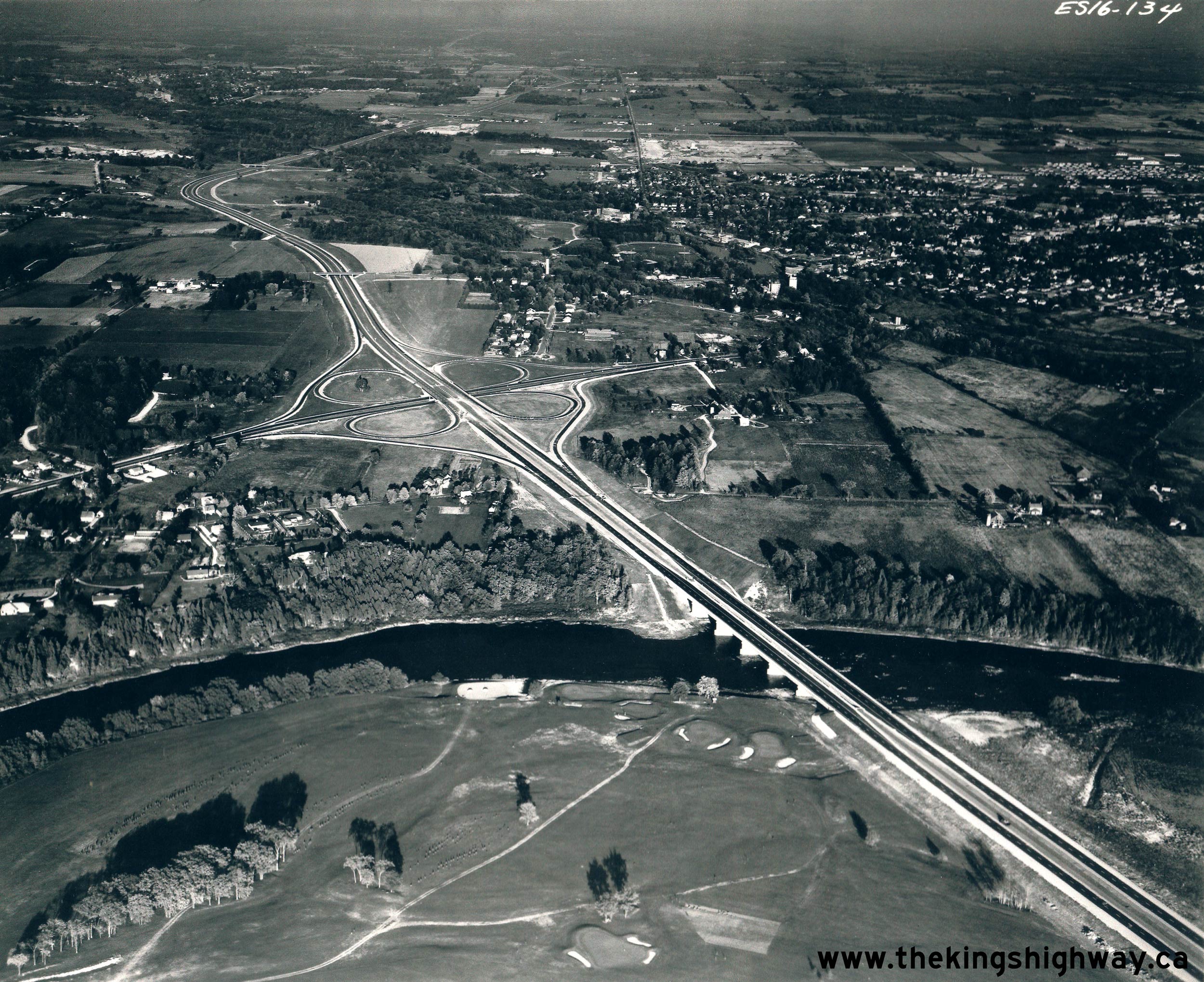
Above - Aerial view of the Hwy 8 Cloverleaf and Grand River Bridge on Hwy 401 between Kitchener and Preston in 1961, facing east. This photo shows the
temporary western end of the completed Toronto-Preston section of Hwy 401 at the Hwy 8 Cloverleaf. Careful observers will note that the westbound lanes of Hwy 401 are
barricaded off at the cloverleaf, with all traffic forced off of the freeway and on to Hwy 8. The westerly extension of Hwy 401 from Preston to Woodstock was opened
to traffic about a month after this photo was taken. See an Enlarged Photo Here. Photo taken in
October 1961. (Photo © Archives of Ontario - Series RG-14-151-21-10 Neg. #2466) 
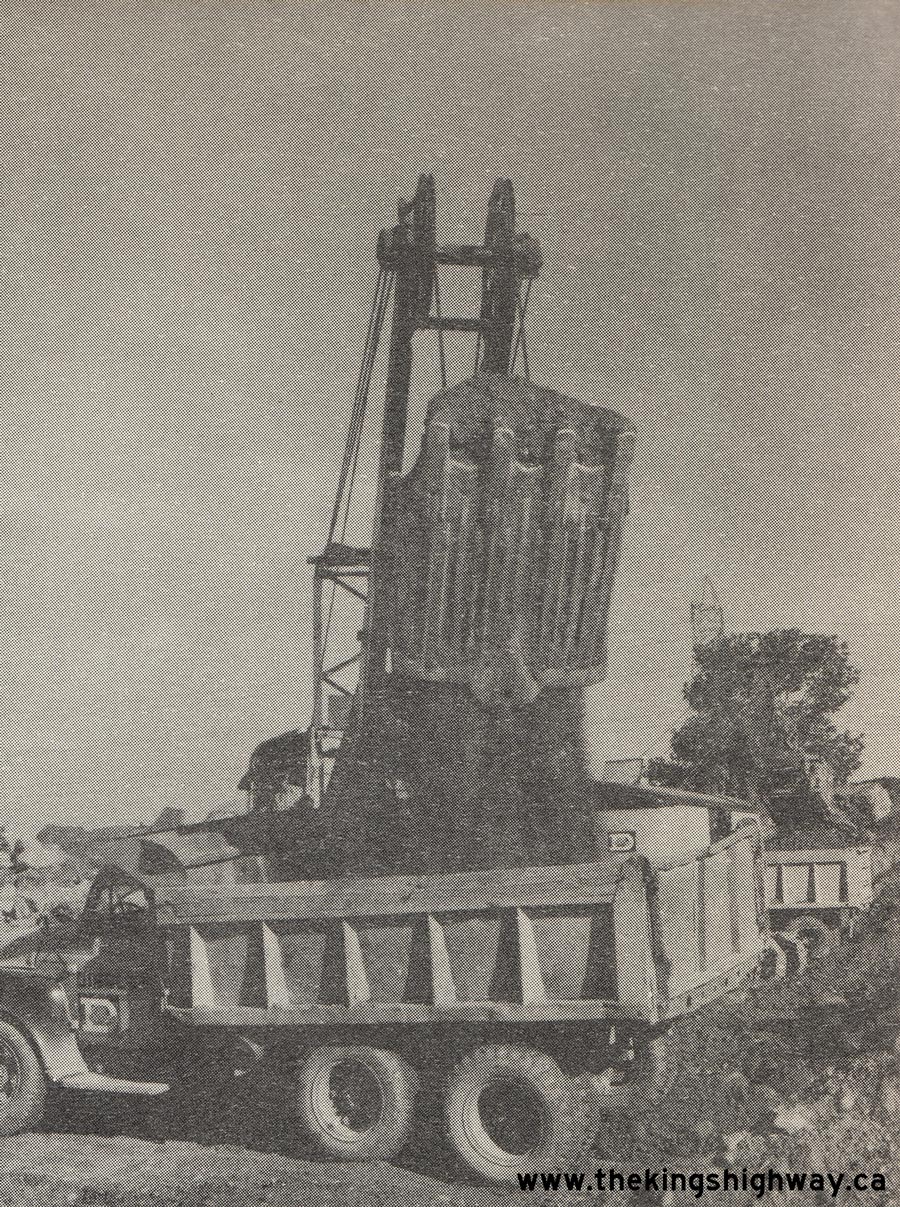
Above - Photo of a scale model of a conceptual pair of Hwy 401 Service Centres from 1961. The decision to construct new Service Centres along Hwy 401 was
announced by Highways Minister W.A. Goodfellow on November 23, 1961. By the end of 1970, 19 Service Centres had been completed along the highway between Windsor
and the Ontario-Quebec Boundary. See an Enlarged Photo Here. Photo taken in 1961. (Photo courtesy of Ontario Ministry of Transportation - © King's Printer for Ontario, 1961) 
Above - Plan from 1961 which illustrates a new section of Hwy 401 being opened to traffic between the Hwy 8 Cloverleaf in Preston and the Hwy 2 Cloverleaf
between Woodstock and Eastwood. This nearly 24-mile extension of Hwy 401 was officially opened to traffic on November 9, 1961. The completion of this gap in Hwy 401
linked the London-Woodstock section of Hwy 401 with the Preston-Toronto section of Hwy 401. As noted on the plan, the completion of the Eastwood-Preston section
opened up a continuous 240-mile stretch of Hwy 401. Thus, it became possible for the first time for motorists to travel between the London area and the Belleville
area on an all-freeway route, via Toronto. See an Enlarged Photo Here. Plan dated 1961. (Photo courtesy of Ontario Ministry of Transportation - © King's Printer for Ontario, 1961) 
Above - Plan from 1961 which illustrates the new 4 1/2-mile Tilbury Bypass section of Hwy 401 being opened to traffic. The Tilbury Bypass allowed through
traffic on Hwy 401 to directly access Hwy 2 to Chatham at the eastern entrance to Tilbury, rather than drive along Hwy 2 through the town's centre. The Tilbury Bypass
was officially opened to traffic on November 20, 1961. See an Enlarged Photo Here. Plan dated
1961. (Photo courtesy of Ontario Ministry of Transportation - © King's Printer for Ontario, 1961) 

Left - Plan from 1961 which illustrates the new 7-mile section of Hwy 401 being opened to traffic between Kingston and Odessa. Like many sections of the
highway in Eastern Ontario, Hwy 401 between Kingston and Odessa was built initially as a two-lane undivided highway, with the south (eastbound) carriageway being used
temporarily by both eastbound and westbound traffic. The highway was expanded from two to four lanes at a later date. This two-lane section of Hwy 401 officially
opened to traffic on December 5, 1961, and was the last new section of Hwy 401 opened to traffic during the busy 1961 construction season. About 75 miles of the new
highway were completed and opened to traffic during 1961. See an Enlarged Photo Here. Plan
dated 1961. (Photo courtesy of Ontario Ministry of Transportation - © King's Printer for Ontario, 1961) Right - Concrete paving operations on a new section of Hwy 401 southwest of London in 1962. See an Enlarged Photo Here. Photo taken in 1962. (Photo courtesy of Ontario Ministry of Transportation - © King's Printer for Ontario, 1962) 

Left - Construction of the new Wymans Road Overpass on Hwy 401 between Belleville and Marysville, Contract #1961-251 (pre-stressed concrete girders) and
Contract #1961-258 (structure and grading). For about 5 years, the Belleville Bypass section of Hwy 401 came to an end at Wymans Road. It wasn't until November 1963
that the highway was completed (initially as a two-lane facility) between Wymans Road and a point just west of the Hwy 41 Interchange near Napanee. See an
Enlarged Photo Here. Photo taken in 1962. (Photo courtesy of Ontario Ministry of Transportation - © King's Printer for Ontario, 1962) Right - Grading underway under Contract #1961-24 for the new Waverley Road Interchange on Hwy 401 near Bowmanville in 1962. Under this contract, two new interchanges were built at Courtice Road and Waverley Road, along with grade separations at each of those two intersections along with a third grade separation at nearby Holt Road. In addition, a new service road was constructed along the southern side of Hwy 401 to remove all local access points from the highway. At the time of the highway's initial construction in the early 1950s, acute shortages of structural steel needed for bridges resulted in several intersections between Oshawa and Newcastle being left as at-grade intersections. See an Enlarged Photo Here. Photo taken in 1962. (Photo courtesy of Ontario Ministry of Transportation - © King's Printer for Ontario, 1962) 

Left - View of Hwy 401 at the Seventh Line (Trafalgar Road) Interchange between Milton and Toronto. See an
Enlarged Photo Here. Photo taken on March 28, 1962. (Photo courtesy of Ontario Ministry of Transportation - © King's Printer for Ontario, 2017) Right - Facing north across the Seventh Line (Trafalgar Road) Overpass on Hwy 401 east of Milton, constructed under Contract #1958-90. See an Enlarged Photo Here. Photo taken on March 28, 1962. (Photo courtesy of Ontario Ministry of Transportation - © King's Printer for Ontario, 2017) 

Left - Oakville Creek Bridge on Hwy 401 east of Milton, constructed under Contract #1958-68. See an
Enlarged Photo Here. Photo taken on March 28, 1962. (Photo courtesy of Ontario Ministry of Transportation - © King's Printer for Ontario, 2017) Right - 5th Line Underpass on Hwy 401 east of Milton, constructed under Contract #1957-274. See an Enlarged Photo Here. Photo taken on March 28, 1962. (Photo courtesy of Ontario Ministry of Transportation - © King's Printer for Ontario, 2017) 

Left - East Don River Bridge on Hwy 401 in Toronto in 1962. This interesting photo shows the highway crossing the original 1956 East Don River Bridge, prior to the
construction of the collector lane system along Hwy 401 across Toronto in the 1960s. Note how rural the area was between Leslie Street and Don Mills Road at that
time! The East Don River Bridge was constructed under Contract #1955-16. See an Enlarged Photo Here. Photo taken in March 1962. (Photo courtesy of Ontario Ministry of Transportation - © King's Printer for Ontario, 2014) Right - Agincourt CPR Overhead on Hwy 401 near Kennedy Road in Scarborough, constructed under Contract #1955-75. See an Enlarged Photo Here. Photo taken in March 1962. (Photo courtesy of Ontario Ministry of Transportation - © King's Printer for Ontario, 2014) 
Above - Facing west along Hwy 401 towards Toronto at the Liverpool Road Overpass in Pickering Township in 1962. This great photo shows the original 1947
Liverpool Road Overpass and four-lane cross section of Hwy 401 through Ontario County (now part of the Regional Municipality of Durham), as it existed before the
highway's expansion to six lanes in the mid-1970s. See an Enlarged Photo Here. Photo taken on
May 11, 1962. (Photo © Archives of Ontario - Series RG-14-162-5-166, Photo #8) 
Above - Humber River Bridge on Hwy 401 in Toronto in 1962. This photo shows the new Humber River Bridge that was built in 1955 under Contract #1955-01 to
replace the bridge that was destroyed during Hurricane Hazel in October 1954. The original Hwy 401 bridge at this site was completed in 1954, but was lost during
Hurricane Hazel shortly before the bridge was scheduled to open to traffic. The unprecedented rainfall from the storm caused the normally peaceful Humber River to
swell into a violent torrent of water. The rushing water scoured the riverbed, eventually undermining the bridge piers. The damage to the Humber River Bridge was so
severe that DHO engineers had little choice but to condemn the unopened bridge. The damaged bridge was demolished in November 1954 to make way for the replacement
bridge seen here. Photo taken in May 1962. (Photo courtesy of Ontario Ministry of Transportation - © King's Printer for Ontario, 2011) 

Left - North side of the Humber River Bridge on Hwy 401 in Toronto in 1962. The overpass across the highway in the background marks the Weston Road
Interchange. When the Toronto Bypass was first built in the early 1950s, the Weston Road Interchange was only a four-ramp partial cloverleaf, with all of the ramps
situated on the eastern side of Weston Road. This "A-B Parclo" configuration proved to be an economical design solution for the Weston Road Interchange, since it
avoided the cost of building ramp bridges across the adjacent Humber River. During the reconstruction and widening of Hwy 401 during the 1960s, the original 1952
Weston Road Overpass seen here was demolished and the entire interchange was reconfigured into a "Parclo A-4" ramp configuration. Two of the new ramps on the western
side of the interchange spanned the Humber River on separate structures, something which the original designers of the Toronto Bypass had obviously tried to avoid,
given the initial interchange configuration. See an Enlarged Photo Here. Photo taken in May
1962. (Photo courtesy of Ontario Ministry of Transportation - © King's Printer for Ontario, 2011) Right - Bayview Avenue Interchange on Hwy 401 in Toronto in 1962. This photo shows the original Bayview Avenue Cloverleaf and Overpass, which were both constructed in 1953. The original cloverleaf interchange at Bayview Avenue was completely replaced in 1968 during the widening of Hwy 401. Compare this 1962 photo of the Bayview Avenue Underpass to this 1968 Photo. See an Enlarged Photo Here. Photo taken in May 1962. (Photo courtesy of Ontario Ministry of Transportation - © King's Printer for Ontario, 2011) 
Above - Wendell Avenue Underpass on Hwy 401 in Toronto in 1962. This photo shows the original structure that was built in 1950 to carry the Toronto Bypass over
Wendell Avenue. The bridge was expanded considerably in 1964 to accommodate the widening of Hwy 401 into an Express-Collector Lane System. See an
Enlarged Photo Here. Photo taken in May 1962. (Photo courtesy of Ontario Ministry of Transportation - © King's Printer for Ontario, 2011) 
Above - Plan from 1962 which illustrates a new section of Hwy 401 being opened to traffic between Cornwall and Lancaster. This 13-mile section of Hwy 401 was
officially opened to traffic as a two-lane highway from the intersection of Tollgate Road and McConnell Avenue in Cornwall to the Hwy 2 & Hwy 34 Interchange in
Lancaster on September 11, 1962. In conjunction with Tollgate Road across the northern edge of Cornwall, this new section of Hwy 401 allowed through traffic on Hwy 2
to completely bypass Cornwall's City Centre. See an Enlarged Photo Here. Plan dated 1962. (Photo courtesy of Ontario Ministry of Transportation - © King's Printer for Ontario, 1962) 
Above - Plan from 1962 which illustrates a new section of Hwy 401 being opened to traffic between Odessa and Napanee. This 13 3/4-mile extension of Hwy 401 was
officially opened to traffic in an interim two-lane configuration on a single carriageway on November 29, 1962. See an
Enlarged Photo Here. Plan dated
1962. (Photo courtesy of Ontario Ministry of Transportation - © King's Printer for Ontario, 1962) 
 Left - Grading for a new section of Hwy 401 about 7 1/4 miles east of the Hwy 2 Interchange east of Tilbury, Contract #1961-243. See an
Enlarged Photo Here. Photo taken in 1962. Left - Grading for a new section of Hwy 401 about 7 1/4 miles east of the Hwy 2 Interchange east of Tilbury, Contract #1961-243. See an
Enlarged Photo Here. Photo taken in 1962.(Photo courtesy of Ontario Ministry of Transportation - © King's Printer for Ontario, 1962) Right - Construction of the new Hwy 2 Overpass on Hwy 401 at the eastern entrance to Tilbury, Contract #1962-72. See an
Enlarged Photo Here. Photo taken in 1962.(Photo courtesy of Ontario Ministry of Transportation - © King's Printer for Ontario, 1962) 
 Left - Construction of the new Wymans Road Overpass on Hwy 401 between Belleville and Marysville, Contract #1961-251 (pre-stressed concrete girders) and
Contract #1961-258 (structure and grading). At the time, Wymans Road was also known as Drummie's Side Road. See an
Enlarged Photo Here. Photo taken in
1962. Left - Construction of the new Wymans Road Overpass on Hwy 401 between Belleville and Marysville, Contract #1961-251 (pre-stressed concrete girders) and
Contract #1961-258 (structure and grading). At the time, Wymans Road was also known as Drummie's Side Road. See an
Enlarged Photo Here. Photo taken in
1962.(Photo courtesy of Ontario Ministry of Transportation - © King's Printer for Ontario, 1962) Right - Earth excavation for a new section of Hwy 401 between Cornwall and Summerstown, Contract #1961-82. See an
Enlarged Photo Here. Photo taken in 1962.(Photo courtesy of Ontario Ministry of Transportation - © King's Printer for Ontario, 1962) 
 Left - McConnell Avenue Overpass under construction on Hwy 401 in Cornwall, Contract #1961-203. See an
Enlarged Photo Here. Photo taken in 1962. Left - McConnell Avenue Overpass under construction on Hwy 401 in Cornwall, Contract #1961-203. See an
Enlarged Photo Here. Photo taken in 1962.(Photo courtesy of Ontario Ministry of Transportation - © King's Printer for Ontario, 1962) Right - Grading operations underway for a new section of Hwy 401 between Cornwall and Summerstown, Contract #1961-82. See an
Enlarged Photo Here. Photo taken in 1962.(Photo courtesy of Ontario Ministry of Transportation - © King's Printer for Ontario, 1962)  Above - Piers for the new Hwy 11A (Avenue Road) Overpass under construction on the Toronto Bypass (Hwy 401) during the Winter of 1962-1963, Contract #1962-252.
The replacement of the Avenue Road structure was the first phase in the expansion of Hwy 401 from 4 to 12 lanes across Toronto. With the award of this contract on
October 17, 1962, the most extensive reconstruction of an Ontario freeway began - although initially only one mile of the highway through the Avenue Road Interchange
itself was impacted. As seen in this photo, the contractor poured the concrete piers in winter to accelerate construction. Sections of the piers were enclosed in
tarps to ensure that the concrete cured properly, despite cold ambient temperatures. This over-winter work allowed the completion of the new Avenue Road structure by
the end of the 1963 construction season and the removal of the old bridge in December of that year. See an
Enlarged Photo Here. Photo taken in 1963. Above - Piers for the new Hwy 11A (Avenue Road) Overpass under construction on the Toronto Bypass (Hwy 401) during the Winter of 1962-1963, Contract #1962-252.
The replacement of the Avenue Road structure was the first phase in the expansion of Hwy 401 from 4 to 12 lanes across Toronto. With the award of this contract on
October 17, 1962, the most extensive reconstruction of an Ontario freeway began - although initially only one mile of the highway through the Avenue Road Interchange
itself was impacted. As seen in this photo, the contractor poured the concrete piers in winter to accelerate construction. Sections of the piers were enclosed in
tarps to ensure that the concrete cured properly, despite cold ambient temperatures. This over-winter work allowed the completion of the new Avenue Road structure by
the end of the 1963 construction season and the removal of the old bridge in December of that year. See an
Enlarged Photo Here. Photo taken in 1963.(Photo courtesy of Ontario Ministry of Transportation - © King's Printer for Ontario, 1963) 

Left - Hwy 401 at Holt Road in Bowmanville, facing east towards Newcastle. This structure, along with two others at nearby Courtice Road and Waverley Road,
were constructed under Contract #1961-24. Additionally, a Service Road was constructed for a distance of 4 1/2 miles along the south side of Hwy 401 through
Darlington Township from Waverley Road to west of Courtice Road. This new Service Road eliminated all local access points to the divided highway and permitted access
to and from Hwy 401 at the interchanges only. Like many of Ontario's Controlled-Access Highways built immediately after World War II, some low-volume roads had to be
left as temporary at-grade intersections, due to chronic Post-War shortages of structural steel required for grade separations. See an
Enlarged Photo Here. Photo taken on March 20, 1963. (Photo courtesy of Ontario Ministry of Transportation - © King's Printer for Ontario, 2014) Right - Facing south across the Holt Road Overpass on Hwy 401 in Bowmanville in 1963. The present-day location of the entrance to Ontario Power Generation's Darlington Nuclear Generating Station lies at the point where Holt Road ends in the background of this photo. See an Enlarged Photo Here. Photo taken on March 20, 1963. (Photo courtesy of Ontario Ministry of Transportation - © King's Printer for Ontario, 2014) 
 Left - Circa 1963 postcard view of Hwy 401 near the Wooler Road Interchange west of Trenton. Note the sign indicating the Service Centre just ahead. Four new
Service Centres were constructed and opened along Hwy 401 between Oshawa and Trenton in 1962, in order to give motorists access to 24-hour fuel and food services. See
an Enlarged Photo Here. Photo taken circa 1963. Left - Circa 1963 postcard view of Hwy 401 near the Wooler Road Interchange west of Trenton. Note the sign indicating the Service Centre just ahead. Four new
Service Centres were constructed and opened along Hwy 401 between Oshawa and Trenton in 1962, in order to give motorists access to 24-hour fuel and food services. See
an Enlarged Photo Here. Photo taken circa 1963.(Photograph courtesy of Len Leiffer) Right - Circa 1963 postcard view of Hwy 401 approaching the Wooler Road Interchange west of Trenton. See an
Enlarged Photo Here. Photo taken circa 1963.(Photograph courtesy of Len Leiffer) 
Above - Plan from 1963 which illustrates the proposed expansion of Hwy 401 between Keele Street and Yonge Street (Hwy 11) in Toronto from four lanes to 12
lanes. The first construction contract for the replacement of the Hwy 11A (Avenue Road) Cloverleaf was awarded in October 1962 and was completed in the Fall of 1964.
See an Enlarged Photo Here. Plan dated 1963. (Photo courtesy of Ontario Ministry of Transportation - © King's Printer for Ontario, 1963) 
Above - Aerial view of the construction progress at the Hwy 11A (Avenue Road) Cloverleaf on Hwy 401 in Toronto, Contract #1962-252. This photo was taken in
the Summer of 1963 and shows the nearly-completed replacement Avenue Road Overpass crossing the new 12-lane widened section of Hwy 401. The new structure sits beside
the original 1952 structure crossing the old four-lane Toronto Bypass. The old Avenue Road structure was taken out of service and demolished a few months after
this photo was taken. See an Enlarged Photo Here. Photo taken in 1963. (Photo courtesy of Ontario Ministry of Transportation - © King's Printer for Ontario, 1963) 
Above - New northbound Harwood Avenue Overpass on Hwy 401 in Ajax in 1963. Completed in late 1961 under Contract #1960-275, the new twin structure carries
northbound Harwood Avenue traffic over Hwy 401. The original 1941 structure seen in the background was converted into a one-way street carrying southbound traffic
only. See an Enlarged Photo Here. Photo taken in September 1963. (Photo courtesy of Ontario Ministry of Transportation - © King's Printer for Ontario, 2012) 

Left - Circa 1963 view of Hwy 401, facing east towards the new Ingersoll Service Centres from the Foldens Line Overpass (today's Interchange #222, also known
as Oxford Road 6). Noticeably absent in this photo from the early 1960s are the interchange ramps which exist today at Oxford Road 6. This interchange was not built
as part of Hwy 401's initial construction in the 1950s. The interchange was a comparatively recent development, having only been built in the early 1980s. See an
Enlarged Photo Here. Photo taken circa 1963. (Photo © Laurie Esseltine) Right - View of Hwy 401 the same location in 2003, facing east towards the Ingersoll Service Centres from Foldens Line (Oxford Road 6). See an Enlarged Photo Here. Photo taken in 2003. (Photo © Laurie Esseltine) 

Left - A 1963 staff photo of the first Department of Highways of Ontario (DHO) Emergency Road Patrol for Hwy 401 across Metropolitan Toronto. This emergency
response unit was stationed at DHO Headquarters at Downsview and commenced complimentary emergency services along an 18-mile section of Hwy 401 on June 6, 1963. The
unit responded to various freeway traffic incidents, including collisions, vehicle breakdowns, flat tires, First Aid and even minor vehicle repairs. In fact, if a
motorist ran out of fuel along Hwy 401 across Toronto in the 1960s, the DHO would even supply up to a gallon of complimentary gasoline in order to ensure that the
disabled vehicle could be safely driven off of the freeway for refuelling! The DHO Emergency Road Patrol was an intriguing early example of freeway traffic and
incident management by the Department, in recognition of growing traffic volumes along Hwy 401 and the immediate effects these incidents often had on traffic flow.
The Emergency Road Patrol was very well-utilized - the unit responded to over 23,000 incidents by the end of the 1963/64 Fiscal Year. The Emergency Road Patrol
originally operated along Hwy 401 between Hwy 27 and Kennedy Road only, but services were gradually expanded to other Toronto-area freeways as the years went by.
Sadly, the Emergency Road Patrol was discontinued in the 1990s as a cost-cutting measure. See an
Enlarged Photo Here. Photo taken in 1963. (Photo courtesy of Ontario Ministry of Transportation - © King's Printer for Ontario, 1963) Right - Henry Street Overpass on Hwy 401 in Whitby in 1963. Note the early freeway exit sign for Brock Street South in the foreground. At the time this photo was taken, freeway exits in Ontario were usually marked using small plywood guide signs such as this one. While larger extruded aluminum signs began to appear for some major interchanges along Hwy 401 by the end of the 1950s, it really wasn't until the early 1970s that large metal signs were regularly used at freeway exits. See an Enlarged Photo Here. Photo taken in August 1963. (Photo courtesy of Ontario Ministry of Transportation - © King's Printer for Ontario, 2011) 

Left - Plan from 1963 which illustrates the new 8 1/2-mile section of Hwy 401 being opened to traffic between Napanee and Marysville. This section of Hwy 401
was built initially as a two-lane undivided highway, with the south (eastbound) carriageway being used temporarily by both eastbound and westbound traffic. The
highway was expanded from two to four lanes at a later date. This two-lane section of Hwy 401 officially opened to traffic on November 1, 1963. This new highway
section linked the Toronto-Belleville section of Hwy 401 to the previously-completed Napanee to Gananoque section of Hwy 401. See an
Enlarged Photo Here. Plan dated 1963. (Photo courtesy of Ontario Ministry of Transportation - © King's Printer for Ontario, 1963) Right - Concrete paving operations along Hwy 401 between Napanee and Marysville, Contract #1962-123. See an Enlarged Photo Here. Photo taken in 1963. (Photo courtesy of Ontario Ministry of Transportation - © King's Printer for Ontario, 1963) 

Left - Expansion of the Wilson Avenue Underpass on Hwy 401 in Toronto for the new Express-Collector Lane System, Contract #1963-99. The original four-lane
Toronto Bypass structure over Wilson Avenue can be seen in the background. This structure was completed in 1950. See an
Enlarged Photo Here. Photo taken in 1963. (Photo courtesy of Ontario Ministry of Transportation - © King's Printer for Ontario, 1963) Right - Hwy 2 Overpass and Sutherland Creek Bridges nearing completion on Hwy 401 near the Ontario-Quebec Boundary, Contract #1962-82. See an Enlarged Photo Here. Photo taken in 1963. (Photo courtesy of Ontario Ministry of Transportation - © King's Printer for Ontario, 1963) 

Left - Concrete paving operations along Hwy 401 between Napanee and Marysville, Contract #1962-123. See an
Enlarged Photo Here. Photo taken in 1963. (Photo courtesy of Ontario Ministry of Transportation - © King's Printer for Ontario, 1963) Right - Scane Road Overpass under construction on Hwy 401, about 2 miles west of the Hwy 21 Interchange, Contract #1964-106. This was one of many structures built across Hwy 401 in Southwestern Ontario to eliminate at-grade intersections at minor crossing roads. Due to other construction priorities, many sections of Hwy 401 were left with at-grade intersections until the mid-to-late 1960s. Scane Road can be seen intersecting a two-lane section of Hwy 401 on the far side of this structure. See an Enlarged Photo Here. Photo taken in 1964. (Photo courtesy of Ontario Ministry of Transportation - © King's Printer for Ontario, 1964)  Above - Aerial view of Hwy 401 facing east towards the Palace Road Interchange. This interesting photo shows the partially-completed Palace Road Interchange in
a staged configuration. When Hwy 401 was initially completed between Odessa and Napanee in November 1962, only the south (eastbound) lanes of the highway were
initially put into service. The south lanes temporarily carried both directions of traffic. Within these interim two-lane sections of Hwy 401, temporary ramps often
had to be constructed at interchanges in order to allow all traffic movements. Here, a temporary T-intersection had to be installed between the two eastbound ramps to
permit movements from the westbound direction, until the north (westbound) lanes of the highway were completed and all interchange ramps were opened to traffic. Note
that the north side of the interchange and westbound lanes were still under construction at the time this photo was taken. See an
Enlarged Photo Here. Photo taken in 1964. Above - Aerial view of Hwy 401 facing east towards the Palace Road Interchange. This interesting photo shows the partially-completed Palace Road Interchange in
a staged configuration. When Hwy 401 was initially completed between Odessa and Napanee in November 1962, only the south (eastbound) lanes of the highway were
initially put into service. The south lanes temporarily carried both directions of traffic. Within these interim two-lane sections of Hwy 401, temporary ramps often
had to be constructed at interchanges in order to allow all traffic movements. Here, a temporary T-intersection had to be installed between the two eastbound ramps to
permit movements from the westbound direction, until the north (westbound) lanes of the highway were completed and all interchange ramps were opened to traffic. Note
that the north side of the interchange and westbound lanes were still under construction at the time this photo was taken. See an
Enlarged Photo Here. Photo taken in 1964.(Photo courtesy of Ontario Ministry of Transportation - © King's Printer for Ontario, 1964) 
Above - Aerial view of the Spadina Expressway (today's Allen Road) Interchange under construction on Hwy 401 between Bathurst Street and Dufferin Street in
Toronto during the Winter of 1963-64. This aerial photo was taken from Dufferin Street facing east. Note the temporary diversion of Hwy 401 around the construction
site at right. Such diversions were common during the reconstruction of Hwy 401 across Toronto during the 1960s, in order to keep all four existing lanes of the
freeway open during construction. As a point of reference, the present-day location of Yorkdale Mall is situated at the bottom right corner of this photo. See an
Enlarged Photo Here. Photo taken in 1964. (Photo courtesy of Ontario Ministry of Transportation - © King's Printer for Ontario, 1964) 
Above - Plan from 1964 showing the proposed expansion of Hwy 401 at the Spadina Expressway Interchange in Toronto. Although the Spadina Expressway was a
Metropolitan Toronto infrastructure project, the DHO still constructed many of the bridges at the expressway's interchange with Hwy 401. This plan identifies the 13
structures built by the Department, while the remainder were built by the municipality. A 3/4-mile temporary diversion for Hwy 401 was constructed around the
interchange site. See an Enlarged Photo Here. Plan dated 1964. (Photo courtesy of Ontario Ministry of Transportation - © King's Printer for Ontario, 1964) 

Left - Concrete paving operations along the south (eastbound) lanes of Hwy 401 west of the Hwy 4 Cloverleaf southwest of London, Contract #1963-92. Between the
Hwy 4 Cloverleaf and Tilbury, Hwy 401 was constructed as a two-lane highway initially. This single carriageway carried both eastbound and westbound Hwy 401 traffic
for about two years, before the north (westbound) carriageway was completed. See an
Enlarged Photo Here. Photo taken in 1964. (Photo courtesy of Ontario Ministry of Transportation - © King's Printer for Ontario, 1964) Right - Grading for the new Jane Street Underpass on Hwy 401 in Toronto, east of the Hwy 400 Interchange, Contract #1963-216. See an Enlarged Photo Here. Photo taken in 1964. (Photo courtesy of Ontario Ministry of Transportation - © King's Printer for Ontario, 1964) 
Above - Construction progress on the Spadina Expressway Interchange on Hwy 401 in Toronto, Contract #1963-217. See an
Enlarged Photo Here. (Photo courtesy of Ontario Ministry of Transportation - © King's Printer for Ontario, 1964)  Above - Plan from 1964 which illustrates the completion of the north (westbound) carriageway of Hwy 401 being opened to traffic from a point 1 mile east of
the Hwy 2 & Hwy 34 Interchange in Lancaster westerly to Cornwall. This 18-mile project twinned the existing two-lane Hwy 401, through the construction of a new
carriageway beside the existing south carriageway. Following completion of the north carriageway, all westbound Hwy 401 traffic was shifted over to the new
carriageway, while the existing south carriageway was converted to carry eastbound traffic only. The north lanes of Hwy 401 were officially opened to traffic between
Lancaster and Cornwall on July 27, 1964. It should be noted that not all structures and interchanges shown on this plan were ultimately constructed as shown. See an
Enlarged Photo Here. Plan dated 1964. Above - Plan from 1964 which illustrates the completion of the north (westbound) carriageway of Hwy 401 being opened to traffic from a point 1 mile east of
the Hwy 2 & Hwy 34 Interchange in Lancaster westerly to Cornwall. This 18-mile project twinned the existing two-lane Hwy 401, through the construction of a new
carriageway beside the existing south carriageway. Following completion of the north carriageway, all westbound Hwy 401 traffic was shifted over to the new
carriageway, while the existing south carriageway was converted to carry eastbound traffic only. The north lanes of Hwy 401 were officially opened to traffic between
Lancaster and Cornwall on July 27, 1964. It should be noted that not all structures and interchanges shown on this plan were ultimately constructed as shown. See an
Enlarged Photo Here. Plan dated 1964.(Photo courtesy of Ontario Ministry of Transportation - © King's Printer for Ontario, 1964)  Above - Plan from 1964 which illustrates the completion of the south (eastbound) carriageway of Hwy 401 being opened to traffic from Currie Road near Dutton
easterly to the Hwy 4 Cloverleaf near Lambeth. This 18-mile project twinned the existing two-lane Hwy 401, through the construction of a new carriageway beside the
existing carriageway. Following completion of the south lanes, all eastbound Hwy 401 traffic was shifted over to the new carriageway, while the existing north
carriageway was converted to carry westbound traffic only. The south lanes of Hwy 401 were officially opened to traffic between Dutton and the Hwy 4 Cloverleaf on July
29, 1964. See an Enlarged Photo Here. Plan dated 1964. Above - Plan from 1964 which illustrates the completion of the south (eastbound) carriageway of Hwy 401 being opened to traffic from Currie Road near Dutton
easterly to the Hwy 4 Cloverleaf near Lambeth. This 18-mile project twinned the existing two-lane Hwy 401, through the construction of a new carriageway beside the
existing carriageway. Following completion of the south lanes, all eastbound Hwy 401 traffic was shifted over to the new carriageway, while the existing north
carriageway was converted to carry westbound traffic only. The south lanes of Hwy 401 were officially opened to traffic between Dutton and the Hwy 4 Cloverleaf on July
29, 1964. See an Enlarged Photo Here. Plan dated 1964.(Photo courtesy of Ontario Ministry of Transportation - © King's Printer for Ontario, 1964) 
Above - Aerial view of the completed 12-lane widening of Hwy 401 at the Hwy 11A (Avenue Road) Interchange in Toronto in 1964, facing east towards
the Hogg's Hollow Bridge. As the population of Toronto exploded upwards following World War II, traffic volumes on the newly-built Toronto Bypass also grew
dramatically. Toronto's population at the end of World War II was only about 650,000. In the 1940s, the highway's original planners had anticipated that four lanes
would be adequate to accommodate traffic along the Toronto Bypass for the foreseeable future. However, within three years of being opened to traffic in 1952, this
section of Hwy 401 was already carrying over 30,000 vehicles per day - roughly three times the traffic volumes that the highway's planners had forecast in the 1940s.
Traffic volumes had more than doubled again from 1955 levels to reach 64,000 vehicles per day by 1960. In response to these rapidly-growing traffic volumes along the
Toronto Bypass, the DHO awarded the first contract for the expansion of Hwy 401 across Metropolitan Toronto on October 17, 1962. The first contract for the widening
of a 1 mile section of the Toronto Bypass included a full replacement of the original Avenue Road Cloverleaf seen in this
1959 Aerial Photo and construction of a new Express-Collector Lane System under Contract
#1962-252. Ontario road map collectors have likely seen this photo before, as it was prominently featured on the front cover of the 1965 Edition of the Official
Ontario Road Map. See an Enlarged Photo Here. Photo taken in October 1964. (Photo courtesy of Ontario Ministry of Transportation - © King's Printer for Ontario, 1964) 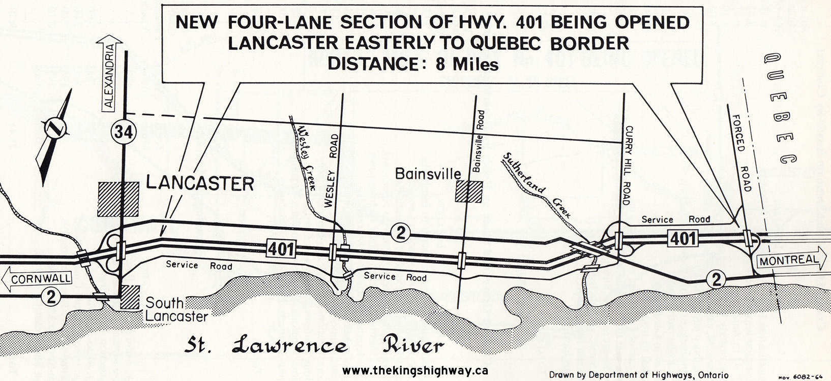 Above - Plan from 1964 which illustrates a new four-lane section of Hwy 401 being opened to traffic from Lancaster to a point immediately west of the
Ontario-Quebec Boundary. This 8-mile extension of Hwy 401 was officially opened to traffic on November 10, 1964. Note the temporary interchange and connection to
Hwy 2 at Forced Road (today's 5th Line Road). The highway on the Quebec side of the boundary (today's Autoroute 20) was not yet complete at the time Hwy 401 reached
the boundary line, which necessitated the DHO to provide a temporary eastern terminus for the freeway at Forced Road. Once Autoroute 20 was opened to traffic, this
temporary interchange was taken out of service and the ramps removed. With the completion of this eastern section of Hwy 401, traffic could proceed from the Quebec
Boundary westerly to Cornwall on a four-lane divided highway. See an Enlarged Photo Here.
Plan dated 1964. Above - Plan from 1964 which illustrates a new four-lane section of Hwy 401 being opened to traffic from Lancaster to a point immediately west of the
Ontario-Quebec Boundary. This 8-mile extension of Hwy 401 was officially opened to traffic on November 10, 1964. Note the temporary interchange and connection to
Hwy 2 at Forced Road (today's 5th Line Road). The highway on the Quebec side of the boundary (today's Autoroute 20) was not yet complete at the time Hwy 401 reached
the boundary line, which necessitated the DHO to provide a temporary eastern terminus for the freeway at Forced Road. Once Autoroute 20 was opened to traffic, this
temporary interchange was taken out of service and the ramps removed. With the completion of this eastern section of Hwy 401, traffic could proceed from the Quebec
Boundary westerly to Cornwall on a four-lane divided highway. See an Enlarged Photo Here.
Plan dated 1964.(Photo courtesy of Ontario Ministry of Transportation - © King's Printer for Ontario, 1964)
Continue on to King's Highway 401 Photos: Historical Photos (1965-1969)
|
|---|
Links to Adjacent King's Highway Photograph Pages:
Back to Hwy 401 - Historical Photos (1955-1959)
Hwy 401 Photo Index
On to Hwy 401 - Historical Photos (1965-1969)
Back to King's Highway 400 Photos /
King's Highway 401 History /
On to King's Highway 402 Photos
Ontario Highway History - Main Menu / Back to List of Highways Website contents, photos & text © 2002-2026, Cameron
Bevers (Webmaster) - All Rights Reserved / Contact Me
|
|---|