
| 
| |
|
|
All photographs displayed on this page were taken by the
Webmaster (Cameron Bevers), unless specifically noted otherwise. Historical photographs are
arranged in approximate chronological order, while present day photographs (Year 2000 to date)
are arranged by location from north to south. Click on any thumbnail to see a larger image!
Please note that all photographs displayed on this
website are protected by copyright. These photographs must not be reproduced, published,
electronically stored or copied, distributed, or posted onto other websites without
my written permission. If you want to use photos from this website, please
email me first for permission. Thank-you!
|
|---|
|
Historical Secondary Highway 548 Photographs


Left - The new Department of Highways' St. Joseph Islander Ferry crosses the St. Joseph Channel, shortly after commencing service in 1952. The diesel-powered
ferry could transport up to 12 vehicles and 70 passengers per crossing. The new St. Joseph Islander Ferry replaced a cable-drawn ferry which provided service between
Pine Island and St. Joseph Island. Photo taken in 1952. (Photo courtesy of Ontario Ministry of Transportation - © King's Printer for Ontario, 1952) Right - St. Joseph Islander Ferry approaching the ferry dock southeast of Sault Ste. Marie. The ferry dock's ramp was adjustable using a series of floats and weights to accommodate changes in the water levels throughout the season. Photo taken in 1952. (Photo courtesy of Ontario Ministry of Transportation - © King's Printer for Ontario, 1952) 

Left - Unloading vehicles on the St. Joseph Islander Ferry. Photo taken on August 31, 1953. (Photo courtesy of Ontario Ministry of Transportation - © King's Printer for Ontario, 1953) Right - Pier construction for the new St. Joseph Island Bridge on Hwy 548. Construction began on the new high-level structure in 1970 and was completed three years later. Photo taken in 1971. (Photo courtesy of Ontario Ministry of Transportation - © King's Printer for Ontario, 1971) 

Left - View of the St. Joseph Island Bridge while under construction in 1972, facing north from the Twyning Islands (1972) (Photo courtesy of Ontario Ministry of Transportation - © King's Printer for Ontario, 1972) Right - New St. Joseph Island Bridge on Hwy 548 shortly after completion in 1973, facing south. The new St. Joseph Island Bridge was completed and officially opened to traffic on September 25, 1973. (Photo courtesy of Ontario Ministry of Transportation - © King's Printer for Ontario, 1973) 
Above - Completed St. Joseph Island Bridge on Hwy 548, as seen from King's Island (1974) (Photo courtesy of Ontario Ministry of Transportation - © King's Printer for Ontario, 1974) |
|---|
|
Present Day Secondary Highway 548 Photographs


Left - Green guide sign approaching the Hwy 548 Junction on Eastbound Hwy 17 near Desbarats. Hwy 548 forms the only road link to nearby St. Joseph Island on
Lake Huron. See an Enlarged Photo here. (Photograph taken on September 1, 2008 - © Cameron Bevers) Right - Facing south along Hwy 548 from the Hwy 17 Junction near Desbarats. Note the older highway distance sign, which still has an educational "km" tab affixed to it. After Ontario's highways converted to Metric measurements in 1977, these tabs were placed on all distance signs to advise motorists that the distances were in kilometres, not miles. Although many of the these "km" tabs have been removed from distance signs over the years, a handful still remain, particularly on highways which carry a high percentage of tourist traffic. See an Enlarged Photo here. (Photograph taken on September 1, 2008 - © Cameron Bevers) 

Left - Facing east along Eastbound Hwy 17 approaching the Hwy 548 Junction. See an
Enlarged Photo here. (Photograph taken on September 1, 2008 - © Cameron Bevers) Right - Facing north along Hwy 548 from the King's Island Roadside Park Entrance. In the late 1940s and early 1950s, a new road was constructed from Hwy 17 southerly to Bamford Island in order to provide access to the new Department of Highways' Ferry to St. Joseph Island. This new highway linked the Mainland to the north ferry dock on Bamford Island by means of a bridge and two short causeways. See an Enlarged Photo here. (Photograph taken on July 15, 2007 - © Cameron Bevers) 

Left - View of the King's Island Roadside Park on Hwy 548. This park was established in the 1950s for the convenience of motorists using the St. Joseph Island
Ferry or the nearby Trans-Canada Highway (Hwy 17). The park offers picnic tables, washrooms, parking areas and panoramic waterfront views of Lake Huron's North
Channel (known specifically at this point as the St. Joseph Channel). See an Enlarged Photo here. (Photograph taken on July 15, 2007 - © Cameron Bevers) Right - The King's Island Roadside Park is arguably one of the most scenic roadside stops along the entire Ontario provincial highway system. This rugged, rocky island with its majestic, windswept white pines is a perfect snapshot of Northern Ontario's beauty. This hidden, largely undiscovered scenic gem is located a mere 2 km south of Hwy 17 on Hwy 548. Travelers on Hwy 17 between Sudbury and Sault Ste. Marie are well advised to take a short detour down Hwy 548 and enjoy the magnificent scenery of King's Island. See an Enlarged Photo here. (Photograph taken on July 15, 2007 - © Cameron Bevers) 

Left - View of the St. Joseph Island Bridge from the King's Island Roadside Park. This bridge forms the only highway link between the Mainland and St. Joseph
Island. The bridge actually spans between Bamford Island and the Twyning Islands, after which a series of short causeways and a bridge connect Hwy 548 to St. Joseph
Island. See an Enlarged Photo here. (Photograph taken on July 15, 2007 - © Cameron Bevers) Right - The St. Joseph Island Bridge is 357 metres (1,171 feet) in length. The bridge consists of one 55-metre marine navigation channel span and seven approach spans ranging between 42 metres and 43 metres in length. The marine navigation channel has a minimum vertical clearance of 12.6 metres (41 feet, 6 inches) above mean water level. Although simple in appearance, it is actually a very complex and ingeniously-designed structure. The rugged, rocky terrain and stunning water colour only add to the bridge's aesthetic appeal. The St. Joseph Island Bridge was completed and opened to traffic in 1973. See an Enlarged Photo here. (Photograph taken on July 15, 2007 - © Cameron Bevers) 

Left - Sign at the King's Island Roadside Park commemorating the 1994 dedication of the St. Joseph Island Bridge to Bernt Gilbertson, a former M.P.P. for
Algoma who championed the construction of a bridge to St. Joseph Island during the late 1960s. See an
Enlarged Photo here. (Photograph taken on July 15, 2007 - © Cameron Bevers) Right - Facing north along Hwy 548 from the north end of the St. Joseph Island Bridge on Bamford Island. Although one would never guess today, Bamford Island and King's Island were once separated by an open water channel. During construction of the St. Joseph Island Ferry Road in 1948, this channel was filled in with rocks in order to create a short causeway linking the two islands together. See an Enlarged Photo here. (Photograph taken on July 15, 2007 - © Cameron Bevers) 

Left - The double rail parapet wall used for the St. Joseph Island Bridge was the typical barrier design utilized for provincial highway bridges built between
the mid-1960s and late 1970s. See an Enlarged Photo here. (Photograph taken on July 15, 2007 - © Cameron Bevers) Right - North approach to the St. Joseph Island Bridge on Hwy 548, facing south from Bamford Island. See an Enlarged Photo here. (Photograph taken on July 15, 2007 - © Cameron Bevers) 
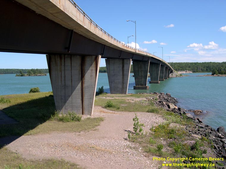
Left - The geometry of Hwy 548 as it crosses the St. Joseph Island Bridge is rather complicated. The bridge has a vertical crest curve at the apex over the
marine navigation channel along with a superelevated horizontal curve at the north end of the structure. This would have been an incredibly challenging bridge to
design! See an Enlarged Photo here. (Photograph taken on July 15, 2007 - © Cameron Bevers) Right - View underneath the St. Joseph Island Bridge, as seen from Bamford Island. The spans are supported on two trapezoidal weathering steel box girders. The designer's choice of this construction material for the bridge's superstructure allowed the curvilinear changes in the roadway alignment, profile and the deck superelevation to be accommodated more easily. The resulting structure has a simple but beautifully streamlined appearance. The bridge was also designed with provisions for an opening span across the marine navigation channel, if such a feature was needed in the future. See an Enlarged Photo here. (Photograph taken on July 15, 2007 - © Cameron Bevers) 

Left - Plaque commemorating the official opening of the St. Joseph Island Bridge on September 25, 1973. See an
Enlarged Photo here. (Photograph taken on July 15, 2007 - © Cameron Bevers) Right - Abandoned Bamford Island Ferry Dock below the St. Joseph Island Bridge on Hwy 548. Ferry service to St. Joseph Island permanently ceased once the new bridge was opened to traffic in 1973. See an Enlarged Photo here. (Photograph taken on July 15, 2007 - © Cameron Bevers) 

Left - Close-up view of the abandoned Bamford Island Ferry Dock. Ferry service to St. Joseph Island began from this dock in December, 1952. Ferry service
continued from this location for more than 20 years, until the completion of the bridge in 1973. See an
Enlarged Photo here. (Photograph taken on July 15, 2007 - © Cameron Bevers) Right - Facing south along Hwy 548 from the St. Joseph Island Bridge. The bridge comes to an end on the Twyning Islands. A short causeway connects the Twyning Islands to the Munroe Islands and then a short bridge connects the Munroe Islands to St. Joseph Island in the background. Up until the 1990s, a sharp reverse curve existed on Hwy 548 on the Munroe Islands. During replacement of the Munroe Islands Bridge in 1996, the highway was straightened out, and the old curve was abandoned. The former Hwy 548 alignment on the Munroe Islands now serves as a parking area for anglers. See an Enlarged Photo here. (Photograph taken on July 15, 2007 - © Cameron Bevers) 

Left - Facing north along Hwy 548 towards the St. Joseph Island Bridge from the Munroe Islands. The former St. Joseph Island Ferry Dock lies immediately to the
right of the bridge on the adjacent Twyning Islands. See an Enlarged Photo here. (Photograph taken on July 15, 2007 - © Cameron Bevers) Right - Abandoned section of Hwy 548 on the Munroe Islands. This former curve in Hwy 548 was abandoned when a new bridge was constructed between St. Joseph Island and the Munroe Islands in 1996. The old highway is now used as a parking area. See an Enlarged Photo here. (Photograph taken on July 15, 2007 - © Cameron Bevers) 

Left - View of the St. Joseph Island Bridge on Hwy 548, facing north from the north tip of St. Joseph Island. The island-hopping route of Hwy 548 across the
St. Joseph Channel is one of the most dramatic and scenic sections of highways in Ontario. See an
Enlarged Photo here. (Photograph taken on July 15, 2007 - © Cameron Bevers) Right - Facing north along Hwy 548 from the Hwy 548 east and west junctions at Kent's Corners. This is one of only two locations on the Ontario highway system where three highways bearing a common route number intersect at a single intersection. The other occurrence is Hwy 587 in Silver Islet, east of Thunder Bay. No matter which provincial highway leg you follow from this intersection, you'll remain on Hwy 548! See an Enlarged Photo here. (Photograph taken on July 1, 2006 - © Cameron Bevers) 
Above - Hwy 548 North and "TO 17" trailblazer route markers at Kent's Corners on St. Joseph Island. This is the only exit road from St. Joseph Island. With no
logical control city to sign at the north end of the highway, northbound Hwy 548 traffic leaving the island is merely directed to Hwy 17. See an
Enlarged Photo here. (Photograph taken on July 1, 2006 - © Cameron Bevers) 
Above - Junction sign assembly marking the east and west legs of Hwy 548 at Kent's Corners. Due to the confusing circular route of Hwy 548 on St. Joseph
Island, special tabs are placed on top of Hwy 548 route markers on St. Joseph Island. These letter tabs indicate the name of the surveyed line that the route follows.
In this case, Line "V" lies to the left, while Line "D" lies to the right. See an
Enlarged Photo here. (Photograph taken on July 1, 2006 - © Cameron Bevers)
More Secondary Highway 548 Photographs Coming Soon!
|
|---|
Links to Adjacent Highway Photograph Pages:
Back to Secondary Highway 546 Photos /
Secondary Highway 548 History /
On to Secondary Highway 551 Photos
Ontario Highway History - Main Menu / Back to List of Highways / Main Photograph Index Page Website contents, photos & text © 2002-2026, Cameron
Bevers (Webmaster) - All Rights Reserved / Contact Me
|
|---|