
| 
| |
|
|
This page contains historical and present day photos of Ontario's King's Highway 61B. All photographs displayed on this page
were taken by the Webmaster (Cameron Bevers), unless specifically noted otherwise. Historical photographs are arranged in approximate chronological order, while
present day photographs (Year 2000 to date) are arranged by location from south to north. Click on any thumbnail to see a larger image!
Please note that all photographs displayed on this
website are protected by copyright. These photographs must not be reproduced, published,
electronically stored or copied, distributed, or posted onto other websites without
my written permission. If you want to use photos from this website, please
email me first for permission. Thank-you!
|
|---|
|
Historical King's Highway 61B Photographs

Above - Circa 1930 view of Mount McKay and the Kaministiquia River Bridge on the Scott Highway (Hwy 61) approaching Fort William. This unusual road and railway
bridge carried traffic on Hwy 61 up until the completion of the Lakehead Expressway (Hwy 61 New) further upstream in the late 1960s. Traffic on the Scott Highway was
accommodated on two cantilevered deck extensions which flanked the main trusses of the railway bridge. Each deck extension carried one direction of traffic only. The
Scott Highway was administered by Ontario's Department of Northern Development up until 1937, when the route was placed under the jurisdiction of the DHO and was
designated as King's Highway 61. The Kaministiquia River Bridge still stands today on James Street (Old Hwy 61), nearly a century later. See an
Enlarged Photo Here. (Photo courtesy of The Camera Shop, Port Arthur) 

Left - New DHO Fort William District Office on Hwy 17 (Arthur Street) at the Hwy 61 Junction in 1955. The Thunder Bay (Northwestern Regional Office) is now
located on James Street. The former DHO Fort William District Office seen here was subsequently re-purposed after the DHO moved out, although the building itself
still stands today at 1825 Arthur Street East at the corner of Kingsway. Note the Hwy 17 & Hwy 61 junction sign assembly at right. See an
Enlarged Photo Here. Photo taken in 1955. (Photo courtesy of Ontario Ministry of Transportation - © King's Printer for Ontario, 1955) Right - Circa 1955 postcard view of James Street (Hwy 61, later known as Hwy 61B) in Fort William with Mount McKay in the background. See an Enlarged Photo Here. (Photo courtesy of Alex Wilson Publishing Ltd, Dryden) 
Above - Circa 1955 postcard view of the Fort William Welcome Arch on Hwy 61 (later known as Hwy 61B). See an
Enlarged Photo Here. Photo courtesy of Western Smallware & Stationery Co. 

Left - View of Hwy 61 (later known as Hwy 61B) approaching the Fort William Welcome Arch in 1959. See an
Enlarged Photo Here. Photo taken in August 1959. (Photo from Cameron Bevers' historical photograph collection - Original photographer unknown) Right - Departing from Fort William on Hwy 61 (later known as Hwy 61B) in 1959, facing south. This photo shows the less-commonly seen side of the Fort William Welcome Arch facing southbound Hwy 61 traffic, which bears the simple message "FORT WILLIAM SAYS FAREWELL". See an Enlarged Photo Here. Photo taken in August 1959. (Photo from Cameron Bevers' historical photograph collection - Original photographer unknown) 
Above - View of Ford Street (Hwy 61, later known as Hwy 61B) facing south from Francis Street in Fort William (now part of Thunder Bay). Note the unusual
hatched yellow pedestrian crosswalk painted across Ford Street. During the 1950s, traffic engineering practices and traffic control devices were generally
standardized across North American jurisdictions, under the Manual of Uniform Traffic Control Devices (MUTCD). The adoption of the MUTCD in Ontario ultimately
supplanted all local standards and practices, which made non-conforming examples such as this hatched pedestrian crosswalk obsolete. See an
Enlarged Photo Here. Photo taken in August 1959. (Photo from Cameron Bevers' historical photograph collection - Original photographer unknown) |
|---|
|
Present Day King's Highway 61B Photographs


Left - Facing south along Hwy 61 towards Pigeon River near the Hwy 61B Junction (Chippewa Road) south of Thunder Bay. Approximately 53 km south of here, Hwy 61
reaches the International Boundary at Pigeon River where the highway crosses over into the United States. Pigeon River is the only highway crossing between Canada and
the United States in the Thunder Bay area. The next closest highway crossing between Canada and the United States lies approximately 350 km to the west, where the
International Bridge connects Fort Frances, Ontario with International Falls, Minnesota. The next highway crossing to the east lies at the other end of Lake Superior
at Sault Ste. Marie, approximately 700 km away. See an Enlarged Photo Here. (Photograph taken on September 1, 2011 - © Cameron Bevers) Right - Distance guide sign for Duluth, Minnesota on southbound Hwy 61 at the Hwy 61B Junction. Although it is unusual to see an out-of-province destination signed on a provincial highway, Duluth was chosen as the control city since there are no other communities of any size along Hwy 61 between Thunder Bay and the International Boundary at the Pigeon River. See an Enlarged Photo Here. (Photograph taken on September 1, 2011 - © Cameron Bevers) 

Left - Facing north along Hwy 61 towards the Hwy 61B Junction (Chippewa Road) south of Thunder Bay. Until the construction of the Lakehead Expressway in the
late 1960s, Hwy 61 used to follow Chippewa Road into Downtown Fort William. The Lakehead Expressway bypassed the cities of Fort William and Port Arthur and provided
a more direct connection between Hwy 61 and Hwy 11 & Hwy 17. The route of Hwy 61 was then moved onto the Lakehead Expressway (later known as the Thunder Bay
Expressway) while the original route of Hwy 61 leading into Downtown via Chippewa Road was renumbered as Hwy 61B. See an
Enlarged Photo Here. (Photograph taken on September 1, 2011 - © Cameron Bevers) Right - Southern terminus of Hwy 61B at the Hwy 61 Junction south of Thunder Bay. A small right turn channelization carries traffic from southbound Hwy 61B to northbound Hwy 61 (Thunder Bay Expressway). A much larger right turn channelization carries traffic from northbound Hwy 61 to northbound Hwy 61B. See an Enlarged Photo Here. (Photograph taken on September 1, 2011 - © Cameron Bevers) 

Left - Facing south along Hwy 61 from the Hwy 61B Junction (Chippewa Road) south of Thunder Bay. The channelization leading from northbound Hwy 61 to
northbound Hwy 61B can be seen at left. The channelization was actually built on the original alignment of Hwy 61 in the 1960s, during construction of the Lakehead
Expressway. See an Enlarged Photo Here. (Photograph taken on September 1, 2011 - © Cameron Bevers) Right - Junction of Hwy 61 & Hwy 61B, facing north towards Thunder Bay. Until the completion of the Lakehead Expressway at the Kaministiquia River in 1968, all Hwy 61 traffic would have curved to the right towards Fort William. A short median island was constructed approaching the intersection. See an Enlarged Photo Here. (Photograph taken on September 1, 2011 - © Cameron Bevers) 

Left - Start of Hwy 61B at the Hwy 61 Junction south of Thunder Bay. Due to the skew of the intersection, a wide median had to be constructed here to keep
the swept path of long transport truck trailers within their own lane when turning left. It is interesting to note that traffic using the right turn channelization
actually has right-of-way priority over the northbound "through" lane. Note the Yield signs on both sides of the northbound lane where it merges with the right turn
channelization. Although this is rather strange right-of-way assignment, the skew of the intersection doesn't really allow the right-of-way to be configured any other
way. The channelization is tangent to Hwy 61B, so there would be a very low likelihood of drivers yielding if the right-of-way was reversed to favour the through
lane. See an Enlarged Photo Here. (Photograph taken on September 1, 2011 - © Cameron Bevers) Right - Junction of Hwy 61 & Hwy 61B, facing south towards Pigeon River. A narrow median island was also constructed on the northern side of the intersection. See an Enlarged Photo Here. (Photograph taken on September 1, 2011 - © Cameron Bevers) 

Left - Facing north along Hwy 61 from the Hwy 61B Junction (Chippewa Road). The Thunder Bay Expressway begins here and continues north through the City of
Thunder Bay. This limited-access highway has occasional grade-separated crossings and several at-grade intersections controlled by traffic signals. See an
Enlarged Photo Here. (Photograph taken on September 1, 2011 - © Cameron Bevers) Right - Approaching the southern terminus of Hwy 61B at the Hwy 61 Junction. The skew of the intersection is rather apparent in this photo. When the Lakehead Expressway was built, the intersection was realigned slightly so that Hwy 61B intersected with Hwy 61 at more or less a right angle. The long channelization at left essentially follows the original alignment of Hwy 61, which existed prior to the construction of the Lakehead Expressway in the 1960s. See an Enlarged Photo Here. (Photograph taken on September 1, 2011 - © Cameron Bevers) 

Left - Facing north along Hwy 61B from the Hwy 61 Junction south of Thunder Bay. Spectacular Mount McKay rises above the highway at right. See an
Enlarged Photo Here. (Photograph taken on August 28, 2003 - © Cameron Bevers) Right - Approaching Mount McKay on Hwy 61B, facing north towards Thunder Bay. This dramatic peak is the highest in a series of mountains along the Lake Superior shoreline known as the Nor'Westers. Mount McKay has a summit elevation of approximately 483 metres above sea level (1,585 feet). See an Enlarged Photo Here. (Photograph taken on September 1, 2011 - © Cameron Bevers) 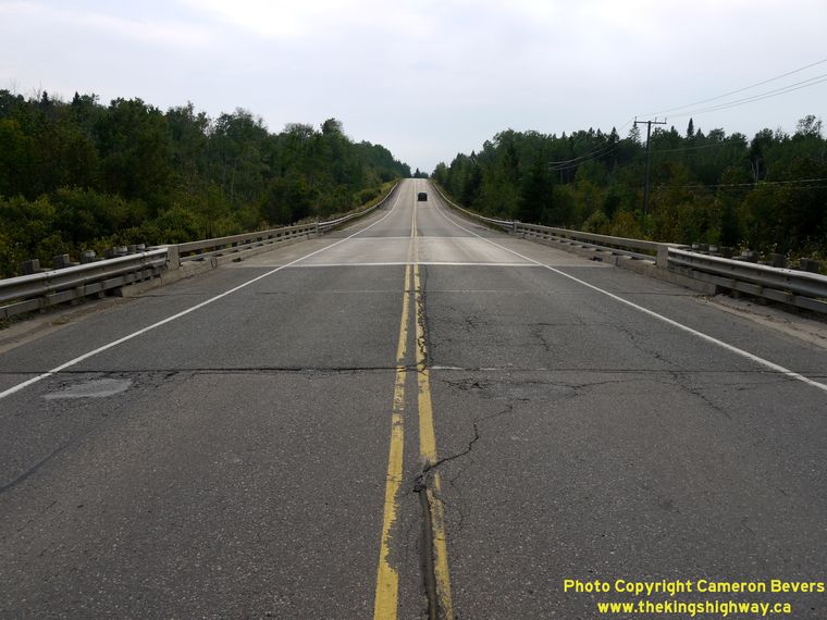

Left - Facing south along Hwy 61B at the Mosquito Creek Bridge south of Thunder Bay. See an
Enlarged Photo Here. (Photograph taken on September 1, 2011 - © Cameron Bevers) Right - Western side of the Mosquito Creek Bridge on Hwy 61B. This single-span steel beam structure was completed in 1970. See an Enlarged Photo Here. (Photograph taken on September 1, 2011 - © Cameron Bevers) 

Left - Facing north along Hwy 61B towards Thunder Bay at the Mosquito Creek Bridge. See an
Enlarged Photo Here. (Photograph taken on September 1, 2011 - © Cameron Bevers) Right - Eastern side of the Mosquito Creek Bridge on Hwy 61B. See an Enlarged Photo Here. (Photograph taken on September 1, 2011 - © Cameron Bevers) 

Left - Approaching Thunder Bay on Hwy 61B. This is the approximate site of the old Fort William Welcome Arch, which is visible in the
Historic 1950s Postcard shown above. The Fort William Welcome Arch was
removed from the highway over 40 years ago. See an Enlarged Photo Here. (Photograph taken on September 1, 2011 - © Cameron Bevers) Right - Facing north along James Street (Hwy 61B) approaching the Kaministiquia River Bridge. This interesting structure is actually an old Canadian National (CN) Railway Swing Bridge, which also carries highway traffic. Note the railway line which crosses the northbound lane of Hwy 61B and runs up the highway's centre boulevard. See an Enlarged Photo Here. (Photograph taken on September 4, 2006 - © Cameron Bevers) 

Left - Western side of the Kaministiquia River CN Railway Swing Bridge on James Street (Hwy 61B). See an
Enlarged Photo Here. (Photograph taken on September 4, 2006 - © Cameron Bevers) Right - Facing north across the Kaministiquia River Bridge. The traffic lanes of James Street (Hwy 61B) are cantilevered off of the main railway bridge structure. The northbound lane of Hwy 61B can be seen at right while the southbound lane of Hwy 61B can be seen at left. The CN Railway line occupies the main through truss structure in the centre. See an Enlarged Photo Here. (Photograph taken on September 4, 2006 - © Cameron Bevers) 

Left - The southbound lane of Hwy 61B (James Street) clings to the side of the CN Railway Swing Bridge over the Kaministiquia River. This fascinating structure
was a unique feature on Ontario's King's Highways. No other railway & highway bridges in Ontario were designed quite like this one, with exclusive lanes for
highway traffic in both directions. Although the more famous Little Current Swing Bridge on Hwy 6 southwest of Sudbury carried both highway and railway traffic for
decades, the retrofitted railway bridge's design did not allow for trains and both directions of highway traffic to be accommodated simultaneously on the structure.
See an Enlarged Photo Here. (Photograph taken on September 4, 2006 - © Cameron Bevers) Right - Close-up of the through truss spans of the Kaministiquia River Bridge on James Street in Thunder Bay. Although Hwy 61 (later Hwy 61B) crossed this bridge for almost 60 years, the Kaministiquia River Bridge was never owned by the Department of Highways or Ministry of Transportation. This bridge has always been owned by the railway company ever since it was built more than a century ago. The Department of Highways bypassed the James Street Swing Bridge in the 1960s during construction of the Lakehead Expressway. A new bridge was built exclusively for highway traffic a few kilometres upstream in 1967. The new bridge was opened to traffic in 1968, coinciding with the completion of the Lakehead Expressway between existing Hwy 61 (Chippewa Road) and Broadway Avenue. See an Enlarged Photo Here. (Photograph taken on September 4, 2006 - © Cameron Bevers) 

Left - Traffic heads north across the Kaministiquia River Bridge on Hwy 61B. Until the completion of the southern section of the Lakehead Expressway in 1968,
all traffic entering Fort William and Port Arthur from the United States had to cross this bridge. Although the bridge no longer carries the long-distance through
traffic it once did, the traffic volumes on this structure are quite heavy. The James Street Bridge forms the only direct access to the Fort William First Nation,
which lies to the south of the Kaministiquia River. On October 29, 2013, a mysterious fire on the James Street Bridge prompted CN Railway to close the bridge to
highway traffic and pedestrians. The bridge remained closed until the Fall of 2019, when it was finally reopened. See an
Enlarged Photo Here. (Photograph taken on September 4, 2006 - © Cameron Bevers) Right - James Street (Hwy 61B), facing south towards the Kaministiquia River Bridge. See an Enlarged Photo Here. (Photograph taken on September 4, 2006 - © Cameron Bevers) 

Left - The Kaministiquia River Bridge on Hwy 61B sits in a rather photogenic spot, flanked by Mount McKay to the south. See an
Enlarged Photo Here. (Photograph taken on September 4, 2006 - © Cameron Bevers) Right - Facing south along Hwy 61B towards the Kaministiquia River Bridge at the James Street Railway Subway in Thunder Bay. This single-span steel plate girder structure was completed in 1937. The structure carries both the Canadian National and Canadian Pacific Railways across James Street. See an Enlarged Photo Here. (Photograph taken on September 1, 2011 - © Cameron Bevers) 

Left - Date stamp (1937) on the James Street Railway Subway on Hwy 61B in Thunder Bay. See an
Enlarged Photo Here. (Photograph taken on September 1, 2011 - © Cameron Bevers) Right - Facing north at the James Street Railway Subway in Thunder Bay. Before all of the Thunder Bay Business Routes through downtown were decommissioned, the route of Hwy 61B turned right from James Street onto Frederica Street just a short distance north of the James Street Railway Subway. See an Enlarged Photo Here. (Photograph taken on September 1, 2011 - © Cameron Bevers)
More King's Highway 61B Photographs Coming Soon!
|
|---|
Links to Adjacent King's Highway Photograph Pages:
Back to King's Highway 61 Photos /
King's Highway 61B History /
On to King's Highway 62 Photos
Ontario Highway History - Main Menu / Back to List of Highways Website contents, photos & text © 2002-2026, Cameron
Bevers (Webmaster) - All Rights Reserved / Contact Me
|
|---|