
| 
| |
|
|
This page contains historical photos of Ontario's King's Highway 61 dating from 1917 up to 1999. All photographs displayed on
this page were taken by the Ontario Ministry of Transportation, unless specifically noted otherwise. Historical photographs are arranged in approximate chronological
order. Click on any thumbnail to see a larger image!
Please note that all photographs displayed on this
website are protected by copyright. These photographs must not be reproduced, published,
electronically stored or copied, distributed, or posted onto other websites without
my written permission. If you want to use photos from this website, please
email me first for permission. Thank-you!
|
|---|
|
Page 1: Historical King's Highway 61 Photographs

Above - Circa 1925 photo of the Pigeon River International Bridge at the southern terminus of the Scott Highway (now Hwy 61) south of Port Arthur & Fort
William (now Thunder Bay). This timber deck truss bridge was completed in 1917 by local community groups seeking to provide a road link between the Lakehead Cities
and Duluth, Minnesota. It was soon dubbed the "Outlaw Bridge", as the border crossing was built without authorization or any formal agreement between the Canadian and
United States Governments. After the bridge opened at Pigeon River, both governments scrambled to establish a border post at the bridge. The border crossing was
eventually formalized with the construction of proper permanent customs houses at both ends of the bridge, but initially, the customs "houses" consisted of a small
tent encampment. The original timber deck truss bridge seen here was replaced with a new steel through truss bridge in 1930, but the notorious name "Outlaw Bridge"
lived on in local tales for decades to come. See an Enlarged Photo Here. (Photo courtesy of Lovelady Brothers Studios, Port Arthur) 
  Left - Winter travel on the Scott Highway (Hwy 61) between the Minnesota Boundary and Fort William. See an
Enlarged Photo Here. Photo taken in 1927. Left - Winter travel on the Scott Highway (Hwy 61) between the Minnesota Boundary and Fort William. See an
Enlarged Photo Here. Photo taken in 1927.(Photo courtesy of Ontario Department of Northern Development - © King's Printer for Ontario, 1927) Right - Engineers with the Department of Northern Development inspect progress on widening and improvements to the Scott Highway (Hwy 61). A 5-mile section of
the highway was widened south of Fort William in 1929, along with additional highway diversions which were constructed in 1929-1930 at Pine River, Jarvis River and
Cloud River. A crushed gravel surface was applied to the highway by the Department to improve travel conditions in wet weather. A 15-mile section of the Scott
Highway was surfaced with a retread pavement from Fort William southerly during 1931, with an additional 8 miles of the highway surfaced during 1932. The Scott
Highway was also known as the "International Highway". The route became King's Highway 61 in 1937, when the Department of Northern Development was amalgamated
with the Department of Highways of Ontario (DHO). See an Enlarged Photo Here. Photo taken in
1929.(Photo courtesy of Ontario Department of Northern Development - © King's Printer for Ontario, 1929)  Above - Newly-completed Pigeon River Bridge on the Scott Highway (Hwy 61) in 1930. This new steel bridge on concrete abutments replaced the original timber
"Outlaw Bridge", which was constructed at this location in 1917. The new bridge was built in partnership between the State of Minnesota and the Province of Ontario,
with each government contributing 50% to the replacement bridge's construction costs. The new bridge consisted of a 150-foot main through truss span and a two-lane
24-foot roadway. See an Enlarged Photo Here. Photo taken in 1930. Above - Newly-completed Pigeon River Bridge on the Scott Highway (Hwy 61) in 1930. This new steel bridge on concrete abutments replaced the original timber
"Outlaw Bridge", which was constructed at this location in 1917. The new bridge was built in partnership between the State of Minnesota and the Province of Ontario,
with each government contributing 50% to the replacement bridge's construction costs. The new bridge consisted of a 150-foot main through truss span and a two-lane
24-foot roadway. See an Enlarged Photo Here. Photo taken in 1930.(Photo courtesy of Ontario Department of Northern Development - © King's Printer for Ontario, 1930) 
 Left - Circa 1930 view of Mount McKay and the Kaministiquia River Bridge on the Scott Highway (Hwy 61) approaching Fort William. This unusual road and railway
bridge carried traffic on Hwy 61 up until the completion of the Lakehead Expressway (Hwy 61 New) further upstream in the late 1960s. Traffic on the Scott Highway was
accommodated on two cantilevered deck extensions which flanked the main trusses of the railway bridge. Each deck extension carried one direction of traffic only. The
Scott Highway was administered by Ontario's Department of Northern Development up until 1937, when the route was placed under the jurisdiction of the DHO and was
designated as King's Highway 61. The Kaministiquia River Bridge still stands today on James Street (Old Hwy 61), nearly a century later. See an
Enlarged Photo Here. Left - Circa 1930 view of Mount McKay and the Kaministiquia River Bridge on the Scott Highway (Hwy 61) approaching Fort William. This unusual road and railway
bridge carried traffic on Hwy 61 up until the completion of the Lakehead Expressway (Hwy 61 New) further upstream in the late 1960s. Traffic on the Scott Highway was
accommodated on two cantilevered deck extensions which flanked the main trusses of the railway bridge. Each deck extension carried one direction of traffic only. The
Scott Highway was administered by Ontario's Department of Northern Development up until 1937, when the route was placed under the jurisdiction of the DHO and was
designated as King's Highway 61. The Kaministiquia River Bridge still stands today on James Street (Old Hwy 61), nearly a century later. See an
Enlarged Photo Here.(Photo courtesy of The Camera Shop, Port Arthur) Right - DHO roadside park and campground on Hwy 61 at Middle Falls in 1939. The Middle Falls Roadside Park was located at a beautiful spot along the Pigeon River beside Hwy 61, about 5 miles north of the colourfully infamous "Outlaw Bridge" and the Canada-United States port-of-entry. The DHO initially built this small roadside park in 1937 for the convenience of motorists. The park offered motorists an opportunity to stop and enjoy the scenic view of Middle Falls, which can be seen straddling the Canada-United States Boundary in the background. The park's campground was gradually expanded over the years as motor tourism along Hwy 61 continued to increase. Various new park amenities were added in the 1940s and 1950s. Eventually, the DHO's Middle Falls Park was absorbed into the newly-established Pigeon River Provincial Park. See an Enlarged Photo Here. Photo taken on August 28, 1939. (Photo courtesy of Ontario Ministry of Transportation - © King's Printer for Ontario, 1939) 

Left - Circa 1940 postcard view of the Pigeon River International Bridge at the southern terminus of Hwy 61 south of Port Arthur & Fort William (now
Thunder Bay). This steel structure was completed in 1930, replacing a timber bridge which had been constructed across the Pigeon River in 1917. The original timber
bridge earned the nickname the "Outlaw Bridge", since it was built between Ontario and neighbouring Minnesota without any formal government authorization. This view
was taken from the Minnesota side of the Pigeon River and shows the eastern side of the International Bridge. See an
Enlarged Photo Here. (Photo from Cameron Bevers' historical photograph collection - Original photographer unknown) Right - Circa 1940 coloured postcard view of the western side of the Pigeon River International Bridge, as seen from the bottom of the gorge on the Canadian
side of the river. See an Enlarged Photo Here.(Photo courtesy of the Photogelatine Engraving Company Ltd, Ottawa) 
Above - Circa 1945 postcard view of the Pigeon River International Bridge and Customs Area on Hwy 61 south of Fort William. See an
Enlarged Photo Here. (Photo from Cameron Bevers' historical photograph collection - Original photographer unknown) 
Above - Postcard view of the Pigeon River Hotel and Esso gas station on Hwy 61 (ca. 1948). (Photo from Cameron Bevers' historical photograph collection - Original photographer unknown) 

Left - Resurfaced section of Hwy 61 near Middle Falls. A 20-mile section of Hwy 61 from the Pigeon River International Bridge to the Jarvis River was
resurfaced with hot-mix asphalt under Contract #1948-395. See an Enlarged Photo Here. Photo
taken in 1948. (Photo courtesy of Ontario Ministry of Transportation - © King's Printer for Ontario, 1948) Right - View of the Middle Falls DHO Roadside Park on Hwy 61, located about 35 miles south of Fort William. See an Enlarged Photo Here. Photo taken on July 12, 1949. (Photo courtesy of Ontario Ministry of Transportation - © King's Printer for Ontario, 1949)  Above - Middle Falls DHO Roadside Park on Hwy 61, located about 5 miles north of the Pigeon River International Bridge. This popular roadside park was a
convenient stopping point for motorists travelling between Duluth, Minnesota and the Lakehead Cities of Port Arthur and Fort William (now Thunder Bay). See an
Enlarged Photo Here. Photo taken on July 12, 1949. Above - Middle Falls DHO Roadside Park on Hwy 61, located about 5 miles north of the Pigeon River International Bridge. This popular roadside park was a
convenient stopping point for motorists travelling between Duluth, Minnesota and the Lakehead Cities of Port Arthur and Fort William (now Thunder Bay). See an
Enlarged Photo Here. Photo taken on July 12, 1949.(Photo courtesy of Ontario Ministry of Transportation - © King's Printer for Ontario, 1949) 

Left - View of Hwy 61 approaching the International Bridge between Canada and the United States at Pigeon River. As part of the highway resurfacing which took
place along Hwy 61 in this area during 1948, zone striping (centreline pavement markings) were reapplied to provide increased guidance to motorists and also to
identify both safe and restricted passing areas along the highway. Zone striping had previously been introduced along Hwy 61 during paving operations in the late
1930s. As was the case for most Ontario Highways which were zone-striped during the 1930s, the pavement markings became impossible for the DHO to maintain as World
War II dragged on, due to various equipment, supply and personnel shortages. As supply shortages began to ease in the late 1940s, it became feasible to maintain
pavement markings once again. See an Enlarged Photo Here. Photo taken on July 12, 1949. (Photo courtesy of Ontario Ministry of Transportation - © King's Printer for Ontario, 1949) Right - Construction of a new bridge over the Pine River located about 23 miles south of Fort William by Hewitson Construction, Contract #1950-95. Note the
temporary diversion of Hwy 61 at right and the old concrete bridge at left, which was built by the Department of Northern Development. See an
Enlarged Photo Here. Photo taken on August 21, 1950.(Photo courtesy of Ontario Ministry of Transportation - © King's Printer for Ontario, 1950) 
Above - Circa 1950 postcard view of Hwy 61 near Pigeon River, showing the Middle Falls DHO Roadside Park. See an
Enlarged Photo Here. (Photo from Cameron Bevers' historical photograph collection - Original photographer unknown) 
Above - King's Highway 61 sign and interpretive plaque for the Pigeon River at the DHO's Middle Falls Roadside Park in 1953. In the early 1950s, a new elevated
boardwalk was constructed along the Pigeon River which led from the picnic area to a viewing platform on the Canadian side of Middle Falls. A swimming area was
created for adults between the boardwalk and Hwy 61 to complement a small children's wading pool which was added to the park's growing list of amenities during the
1940s. See an Enlarged Photo Here. Photo taken on August 20, 1953. (Photo courtesy of Ontario Ministry of Transportation - © King's Printer for Ontario, 1953) 
Above - View of the Middle Falls DHO Roadside Park from the side of Hwy 61 in 1953, showing the new boardwalk and swimming area beside the Pigeon River. The
once-busy park at Middle Falls has since been abandoned. The park ceased operations in the early 2000s after nearly 65 years of continuous operation. Apart from the
Pigeon River and the highway itself, almost everything else seen in this photo is now gone. The only notable remaining park feature still visible today is the
children's wading pool near the former park entrance. This small concrete structure was abandoned and left in place after the park closed. See an
Enlarged Photo Here. Photo taken on August 20, 1953. (Photo courtesy of Ontario Ministry of Transportation - © King's Printer for Ontario, 1953) 

Left - Circa 1955 postcard view of the Pigeon River Border Crossing, facing north from the Minnesota side of the bridge. Ontario's King's Highway 61 ends at
the Pigeon River Bridge. However, the highway continues south beyond the Pigeon River towards Duluth as U.S. Route 61 (now known as Minnesota State Highway 61). See
an Enlarged Photo Here. (Photo courtesy of Hamilton Photo Co.) Right - Circa 1955 postcard view of the Fort William Welcome Arch on Hwy 61. See an Enlarged Photo Here. (Photo courtesy of Western Smallware & Stationery Co.) 
Above - View of Hwy 61 about 14 miles north of the Pigeon River Bridge in 1955. See an
Enlarged Photo Here. Photo taken on September 7, 1955. (Photo courtesy of Ontario Ministry of Transportation - © King's Printer for Ontario, 1955) 

Left - New DHO Fort William District Office on Hwy 17 (Arthur Street) at the Hwy 61 Junction in 1955. The Thunder Bay (Northwestern Regional Office) is now
located on James Street. The former DHO Fort William District Office seen here was subsequently re-purposed after the DHO moved out, although the building itself
still stands today at 1825 Arthur Street East at the corner of Kingsway. Note the Hwy 17 & Hwy 61 junction sign assembly at right. See an
Enlarged Photo Here. Photo taken in 1955. (Photo courtesy of Ontario Ministry of Transportation - © King's Printer for Ontario, 1955) Right - Circa 1955 postcard view of James Street (Hwy 61) in Fort William with Mount McKay in the background. See an
Enlarged Photo Here.(Photo courtesy of Alex Wilson Publishing Ltd, Dryden) 

Left - Circa 1958 postcard of the Pigeon River Border Crossing on Hwy 61. See an
Enlarged Photo Here. (Photo courtesy of Western Smallware & Stationery Co.) Right - Circa 1958 postcard view of the Pigeon River Bridge on Hwy 61. See an Enlarged Photo Here. (Photo courtesy of Western Smallware & Stationery Co.) 
 Left - View of Hwy 61 approaching the Fort William Welcome Arch in 1959. See an
Enlarged Photo Here. Photo taken in August 1959. Left - View of Hwy 61 approaching the Fort William Welcome Arch in 1959. See an
Enlarged Photo Here. Photo taken in August 1959.(Photo from Cameron Bevers' historical photograph collection - Original photographer unknown) Right - Departing from Fort William on Hwy 61 in 1959, facing south. This photo shows the less-commonly seen side of the Fort William Welcome Arch facing
southbound Hwy 61 traffic, which bears the simple message "FORT WILLIAM SAYS FAREWELL". See an
Enlarged Photo Here. Photo taken in August 1959.(Photo from Cameron Bevers' historical photograph collection - Original photographer unknown)  Above - View of Ford Street (Hwy 61) facing south from Francis Street in Fort William (now part of Thunder Bay). Note the unusual hatched yellow pedestrian
crosswalk painted across Ford Street. During the 1950s, traffic engineering practices and traffic control devices were generally standardized across North American
jurisdictions, under the Manual of Uniform Traffic Control Devices (MUTCD). The adoption of the MUTCD in Ontario ultimately supplanted all local standards and
practices, which made non-conforming examples such as this hatched pedestrian crosswalk obsolete. See an
Enlarged Photo Here. Photo taken in August 1959. Above - View of Ford Street (Hwy 61) facing south from Francis Street in Fort William (now part of Thunder Bay). Note the unusual hatched yellow pedestrian
crosswalk painted across Ford Street. During the 1950s, traffic engineering practices and traffic control devices were generally standardized across North American
jurisdictions, under the Manual of Uniform Traffic Control Devices (MUTCD). The adoption of the MUTCD in Ontario ultimately supplanted all local standards and
practices, which made non-conforming examples such as this hatched pedestrian crosswalk obsolete. See an
Enlarged Photo Here. Photo taken in August 1959.(Photo from Cameron Bevers' historical photograph collection - Original photographer unknown) 
Above - Circa 1960 postcard of the Pigeon River Hotel & Customs Sign on Hwy 61. (Photo courtesy of Western Smallware & Stationery Co.)  Above - Paving operations underway along Hwy 61 north of the New Pigeon River Bridge, Contract #1961-131. See an
Enlarged Photo Here. Photo taken in 1962. Above - Paving operations underway along Hwy 61 north of the New Pigeon River Bridge, Contract #1961-131. See an
Enlarged Photo Here. Photo taken in 1962.(Photo courtesy of Ontario Ministry of Transportation - © King's Printer for Ontario, 1962)  Above - Construction of the relocated Hwy 61 approaching the New Pigeon River Bridge at the Ontario-Minnesota Boundary, Contract #1961-131. See an
Enlarged Photo Here. Photo taken in 1962. Above - Construction of the relocated Hwy 61 approaching the New Pigeon River Bridge at the Ontario-Minnesota Boundary, Contract #1961-131. See an
Enlarged Photo Here. Photo taken in 1962.(Photo courtesy of Ontario Ministry of Transportation - © King's Printer for Ontario, 1962) 
Above - New Pigeon River Bridge on Hwy 61 south of Port Arthur & Fort William. See an
Enlarged Photo Here. Photo taken in 1962. (Photo courtesy of Ontario Ministry of Transportation - © King's Printer for Ontario, 1962) 
Above - Western side of the newly-completed Pigeon River Bridge on Hwy 61, as seen from the Minnesota end of the bridge. See an
Enlarged Photo Here. Photo taken in 1964. (Photo courtesy of Ontario Ministry of Transportation - © King's Printer for Ontario, 1964) 

Left - Construction of the Kaministiquia River Bridge on the Lakehead Expressway (Hwy 61 New) in Fort William, Contract #1967-99. See an
Enlarged Photo Here. Photo taken in 1968. (Photo courtesy of Ontario Ministry of Transportation - © King's Printer for Ontario, 1968) Right - Reconstruction of Hwy 61 southwest of Fort William, Contract #1969-01. See an Enlarged Photo Here. Photo taken in 1969. (Photo courtesy of Ontario Ministry of Transportation - © King's Printer for Ontario, 1969) 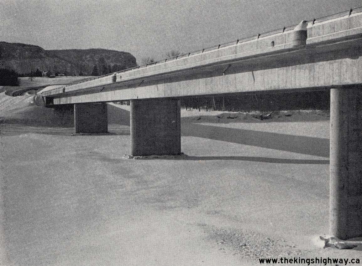
Above - Completed Kaministiquia River Bridge on the Lakehead Expressway (Hwy 61 New) in Fort William (now Thunder Bay). See an
Enlarged Photo Here. Photo taken in 1969. (Photo courtesy of Ontario Ministry of Transportation - © King's Printer for Ontario, 1969)
Continue on to King's Highway 61 Present Day Photos: Pigeon River to Thunder Bay
|
|---|
Links to Adjacent King's Highway Photograph Pages:
Back to King's Highway 60 Photos /
King's Highway 61 History /
On to King's Highway 62 Photos
Ontario Highway History - Main Menu / Back to List of Highways Website contents, photos & text © 2002-2026, Cameron
Bevers (Webmaster) - All Rights Reserved / Contact Me
|
|---|