
| 
| |
|
|
All photographs displayed on this page were taken by the
Webmaster (Cameron Bevers), unless specifically noted otherwise. Historical photographs are
arranged in approximate chronological order, while present day photographs (Year 2000 to date)
are arranged by location from north to south. Click on any thumbnail to see a larger image!
Please note that all photographs displayed on this
website are protected by copyright. These photographs must not be reproduced, published,
electronically stored or copied, distributed, or posted onto other websites without
my written permission. If you want to use photos from this website, please
email me first for permission. Thank-you!
|
|---|
|
Present Day Secondary Highway 626 (#2) Photographs


Left - Blue guide sign indicating the upcoming turn-off to Marathon's Town Centre. Nearly all of the town's amenities are located about 4 km south of Hwy 17,
via Peninsula Road (Formerly Hwy 626). Some highway services are located at the Hwy 17 & Hwy 626 Junction. Motorists who are running low on fuel are well-advised
to fill up at Marathon, as there are no services heading westbound along Hwy 17 until Terrace Bay, which lies about 80 km to the west of Marathon. See an
Enlarged Photo Here. (Photograph taken on August 29, 2011 - © Cameron Bevers) Right - Facing east along Hwy 17 towards the Town of White River from the Former Hwy 626 Junction (Peninsula Road) in Marathon. See an Enlarged Photo Here. (Photograph taken on August 29, 2011 - © Cameron Bevers) 

Left - Approaching the Former Hwy 626 Junction (Peninsula Road) on Hwy 17 in Marathon, facing west. The right-turn lane from northbound Peninsula Road to
eastbound Hwy 17 is channelized. The Marathon Entrance Highway was designated as Secondary Highway 626 in 1978. Hwy 626 remained in the provincial highway system
until 1997, when it was transferred or "downloaded" to the Town of Marathon. See an
Enlarged Photo Here. (Photograph taken on August 29, 2011 - © Cameron Bevers) Right - Approaching the Hwy 17 Junction on northbound Hwy 626 (Peninsula Road). At the time this photo was taken, the directional tabs on the junction assembly at right still reflected the old "North" and "South" cardinal directions for Hwy 17, which were apparently in the process of being changed over during my visit in 2011. See an Enlarged Photo Here. (Photograph taken on August 29, 2011 - © Cameron Bevers) 
Above - Secondary Highway 626 route marker at the Hwy 17 Junction in Marathon. See an
Enlarged Photo Here. (Photograph taken on August 30, 2003 - © Cameron Bevers) 

Left - Junction sign assembly at the northern terminus of Hwy 626 at the Hwy 17 Junction. Note that on this signpost, Hwy 17 is signed with the new "East" and
"West" cardinal direction tabs. Although Hwy 17 does follow a predominantly east-west route from Nipigon to the White River area, there are so few intersecting roads
along this stretch of the highway that cardinal directions are rather irrelevant. See an
Enlarged Photo Here. (Photograph taken on August 29, 2011 - © Cameron Bevers) Right - Destination guide sign approaching the northern terminus of Hwy 626 in Marathon. See an Enlarged Photo Here. (Photograph taken on August 29, 2011 - © Cameron Bevers) 

Left - Close-up of the destination guide sign on Hwy 626. Interestingly, a Helvetica font was used for the lettering on this sign. The Ministry of
Transportation of Ontario (MTO) briefly experimented with Helvetica fonts on green-and-white highway signs in the late 1980s and early 1990s, but subsequently
discontinued the font's use. The vast majority of green-and-white highway guide signs in Ontario use the Federal Highways Administration (FHWA) Highway Gothic font
series for lettering. See an Enlarged Photo Here. (Photograph taken on August 29, 2011 - © Cameron Bevers) Right - Approaching the Former Hwy 626 Junction (Peninsula Road) on Hwy 17 in Marathon, facing east. It would appear that after Hwy 626 was transferred to the municipality in the 1990s, that MTO struggled with how best to sign this turn-off. The combination of a blue guide sign and green guide sign on the same signpost is very unusual. Prior to downloading, Hwy 626 would have had its own signboard on top with a right-pointing arrow, along with a "Marathon" destination tab. For a number of years in the 1950s, Hwy 17 ended in Marathon. See an Enlarged Photo Here. (Photograph taken on August 29, 2011 - © Cameron Bevers) 

Left - Facing west along Hwy 17 towards Terrace Bay from the Peninsula Road (Former Hwy 626) Junction in Marathon. The section of Hwy 17 from Schreiber to
Marathon was completed and opened to traffic in September 1953, after a gruelling 16 years of construction through some of the roughest and most remote terrain found
in the province. Construction of Hwy 17 east of Schreiber was already underway by the late 1930s, but progress was interrupted by the outbreak of World War II.
The DHO's construction of the new highway fell silent in 1940, after the highway had been completed to a point about 8 miles east of Schreiber. After a brief hiatus,
work was resumed on the Trans-Canada Highway during the war by the federal government. Portions of the highway between Marathon and Schreiber were cleared and
constructed by interned Japanese-Canadians. In a particularly shameful and paranoia-fuelled decision in 1942, the Government of Canada forced many Japanese-Canadians
from their homes and into internment camps during World War II. Some of these camps were located in the vicinity of Schreiber. Those who were able-bodied were forced
to work on building sections of the Trans-Canada Highway. The DHO resumed construction activities for the easterly extension of Hwy 17 from Schreiber to Marathon
shortly after World War II ended. The DHO's first Post-War construction contracts for Hwy 17 east of Schreiber were awarded in the Spring of 1947. See an
Enlarged Photo Here. (Photograph taken on August 29, 2011 - © Cameron Bevers) Right - Distance guide sign facing westbound traffic on Hwy 17 at the Hwy 626 Junction (Peninsula Road) in Marathon. See an Enlarged Photo Here. (Photograph taken on August 29, 2011 - © Cameron Bevers) 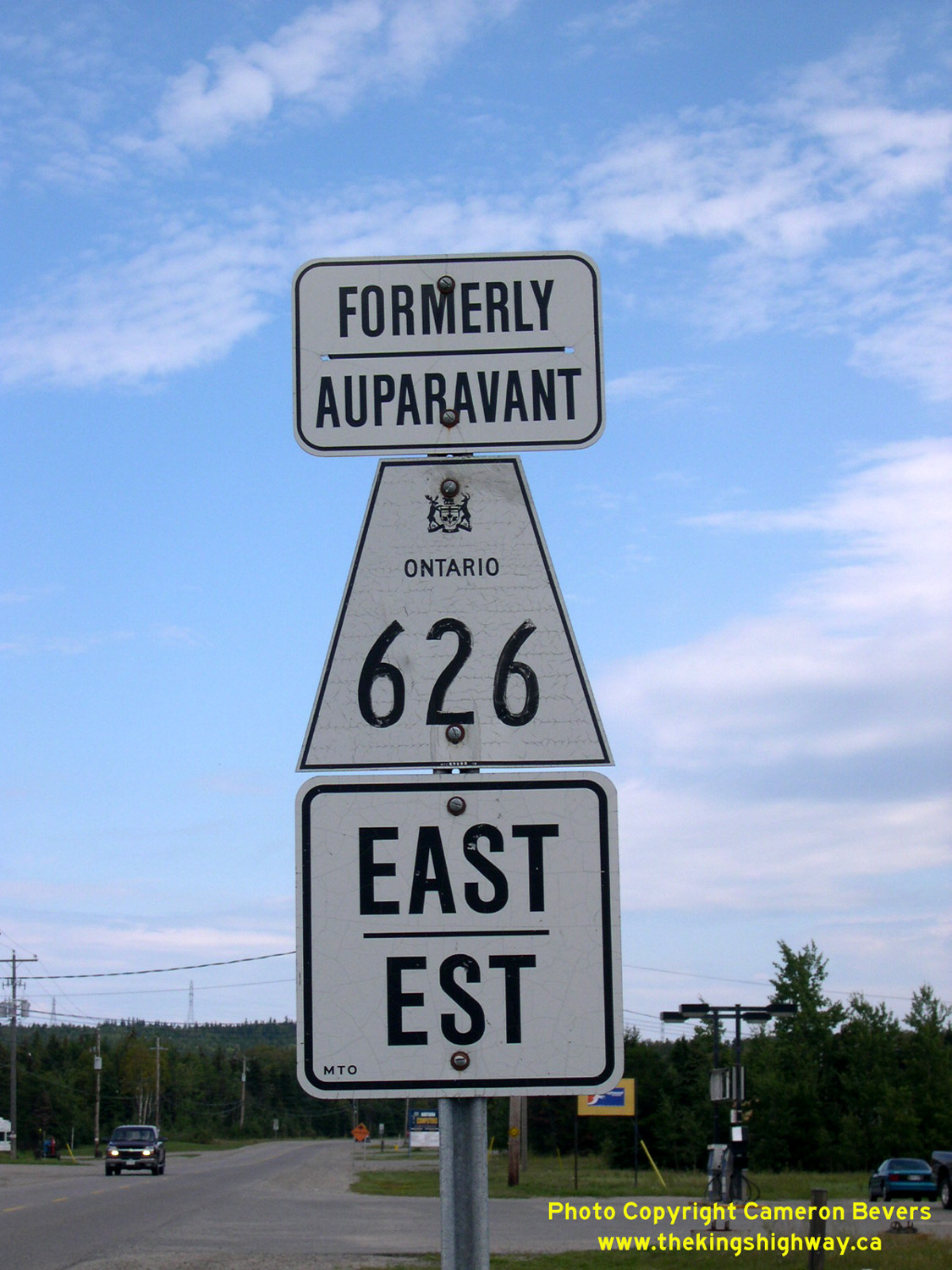
Above - Secondary Highway 626 route marker departing Marathon. See an
Enlarged Photo Here. (Photograph taken on August 30, 2003 - © Cameron Bevers)
More Secondary Highway 626 (#2) Photographs Coming Soon!
|
|---|
Links to Adjacent Highway Photograph Pages:
Back to Secondary Highway 626 (#1) Photos /
Secondary Highway 626 (#2) History /
On to Secondary Highway 627 Photos
Ontario Highway History - Main Menu / Back to List of Highways / Main Photograph Index Page Website contents, photos & text © 2002-2026, Cameron
Bevers (Webmaster) - All Rights Reserved / Contact Me
|
|---|