
| 
| |
|
|
This page contains historical photos of Ontario's King's Highway 69 dating from 1960 to 1979. All photographs displayed on
this page were taken by the Ontario Ministry of Transportation, unless specifically noted otherwise. Historical photographs are arranged in approximate chronological
order. Click on any thumbnail to see a larger image!
Please note that all photographs displayed on this
website are protected by copyright. These photographs must not be reproduced, published,
electronically stored or copied, distributed, or posted onto other websites without
my written permission. If you want to use photos from this website, please
email me first for permission. Thank-you!
|
|---|
|
Page 2: Historical King's Highway 69 Photographs (1960-1979)

Above - Completed Magnetawan River Bridge on Hwy 69 north of Pointe-au-Baril. This beautiful open-spandrel concrete deck arch structure was built under
Contract #1958-150 on a realignment of the Trans-Canada Highway between Byng Inlet and Britt. See an
Enlarged Photo Here. Photo taken in 1960. (Photo courtesy of Ontario Ministry of Transportation - © King's Printer for Ontario, 1960) 
Above - Autumn scene on Hwy 69 near Parry Sound, circa 1960. See an
Enlarged Photo Here. (Photo courtesy of Ed Thatcher) 

Left - Rock drilling operations on a new diversion of Hwy 69, 1 mile north of Parry Sound. See an
Enlarged Photo Here. Photo taken in 1960. (Photo courtesy of Ontario Ministry of Transportation - © King's Printer for Ontario, 1960) Right - Trans-Canada Highway Georgian Bay Route Marker on Hwy 69, located about 10 miles south of Sudbury. See an Enlarged Photo Here. Photo taken on August 31, 1960. (Photo courtesy of Ontario Ministry of Transportation - © King's Printer for Ontario, 1960) 

Left - Facing south along Hwy 103 (later known as Hwy 69) towards the Hwy 12 Junction at the Waubaushene Canadian National Railway (CNR) Overhead. See an
Enlarged Photo Here. Photo taken in October 1961. (Photo courtesy of Ontario Ministry of Transportation - © King's Printer for Ontario, 2022) Right - Western side of the Waubaushene Railway Overhead on the Waubaushene Bypass (Hwy 103, later known as Hwy 69). This new railway overhead was constructed on the Waubaushene Bypass in 1957. This grade separation eliminated an at-grade railway crossing on the original route of Hwy 103 through Waubaushene. See an Enlarged Photo Here. Photo taken in October 1961. (Photo courtesy of Ontario Ministry of Transportation - © King's Printer for Ontario, 2022) 

Left - Matchedash Bay Bridge on Hwy 103 (later known as Hwy 69), facing north towards Port Severn. Constructed under Contracts #1957-27 & #1957-109, this
two-lane structure bypassed the old one-lane Waubaushene Bridge on Old Hwy 103. Traffic using the old highway between Waubaushene and Port Severn had to take turns
crossing the bridge, resulting in periodic traffic delays. See an Enlarged Photo Here. Photo
taken in October 1961. (Photo courtesy of Ontario Ministry of Transportation - © King's Printer for Ontario, 2022) Right - View of the Matchedash Bay Bridge on Hwy 103 (later known as Hwy 69), facing east from Waubaushene. See an Enlarged Photo Here. Photo taken in October 1961. (Photo courtesy of Ontario Ministry of Transportation - © King's Printer for Ontario, 2022) 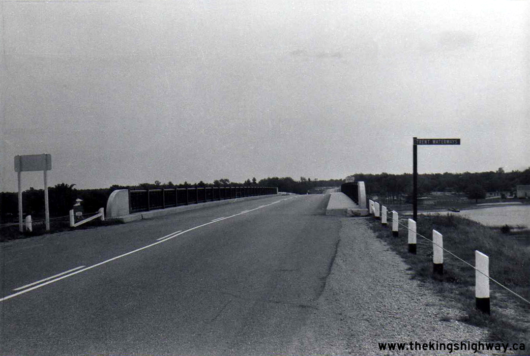
Above - Facing south along Hwy 103 (later known as Hwy 69) on the Port Severn Bypass at the Boat Channel Bridge over the Trent-Severn Waterway. This was one
of three bridges built in the late 1950s to carry the Trans-Canada Highway's Georgian Bay Route across the two branches of the Severn River along with the
Trent-Severn Waterway. See an Enlarged Photo Here. Photo taken in October 1961. (Photo courtesy of Ontario Ministry of Transportation - © King's Printer for Ontario, 2022) 
Above - New railway grade separation on Hwy 69 between Nobel and Parry Sound across the CNR. See an
Enlarged Photo Here. Photo taken in 1961. (Photo courtesy of Ontario Ministry of Transportation - © King's Printer for Ontario, 1961) 
Above - Boat Channel Bridge over the Trent-Severn Waterway on Hwy 103 (later known as Hwy 69) at Port Severn, built under Contract #1957-85. The Port Severn
Bypass allowed through traffic on Hwy 103 to cross the Trent-Severn Waterway via a fixed bridge link. Until the completion of the Port Severn Bypass, traffic bound
for Honey Harbour and points north had to cross the Port Severn Swing Bridge, which opened periodically to allow marine traffic to pass through the canal below. See
an Enlarged Photo Here. Photo taken on September 21, 1962. (Photo courtesy of Ontario Ministry of Transportation - © King's Printer for Ontario, 2022) 

Left - Hwy 69 Bypass at Parry Sound, facing south at the Seguin River Bridge. See an
Enlarged Photo Here. Photo taken in 1962. (Photo courtesy of Ontario Ministry of Transportation - © King's Printer for Ontario, 1962) Right - Construction of the new Naiscoot River Bridge on Hwy 69 north of Pointe-au-Baril, Contract #1962-179. See an Enlarged Photo Here. Photo taken in 1963. (Photo courtesy of Ontario Ministry of Transportation - © King's Printer for Ontario, 1963) 
Above - Autumn colours along Hwy 69 (later known as Hwy 169) north of the Hwy 118 Junction at Glen Orchard in 1963. This photo was featured on the front cover
of the 1966 Edition of the Official Ontario Road Map. See an Enlarged Photo Here. Photo taken
in September 1963. (Photo courtesy of Ontario Ministry of Transportation - © King's Printer for Ontario, 1963) 
Above - Severn River South Branch Bridge on Hwy 103 (later known as Hwy 69) at Port Severn, built under Contract #1957-85. See an
Enlarged Photo Here. Photo taken on October 1, 1963. (Photo courtesy of Ontario Ministry of Transportation - © King's Printer for Ontario, 2022) 

Left - Circa 1965 postcard view of Elm Street (Hwy 17 & Hwy 69) in Downtown Sudbury, facing west from Durham Street. This interesting photo shows the
traffic signals at Durham Street and Elm Street operating in a pedestrian-only phase, where vehicular traffic on all legs of the intersection face a red signal.
Pedestrians were thus allowed to cross the intersection freely in any direction. At the time this photo was taken in the mid-1960s, Hwy 69 turned north via Durham
Street towards Val Caron. The back of the junction assembly can be seen at left, mounted to the traffic signal pole. The section of Hwy 69 through Downtown Sudbury
out to Val Caron and Hanmer was ultimately decommissioned in the late 1970s. Since 1978, Hwy 69 has ended at the Sudbury Southwest Bypass (today's Hwy 17). See an
Enlarged Photo Here. (Photo courtesy of Sudbury News Service Ltd.) Right - Completed Bala Diversion on Hwy 69 (later known as Hwy 169) in 1965, facing north from the Hwy 660 Junction (today's Muskoka Road 38). The new Hwy 69 Diversion in Bala included a new railway subway and bridge over the Moon River. The diversion bypassed the original route of Hwy 69 through Bala, which had a very poor alignment and a narrow single-lane railway subway with limited vertical clearance. The old railway subway at Bala restricted transport truck movements in this part of Ontario for many years. By the 1960s, the subway also began to cause significant traffic delays as motorists often had to wait their turn to squeeze through it. The new diversion seen here greatly improved traffic flow through Bala. See an Enlarged Photo Here. Photo taken in 1965. (Photo courtesy of Henry Fry) 

Left - Eastern side of the Waubaushene Railway Overhead on Hwy 103 (later known as Hwy 69), built under Contract #1957-68. The at-grade railway crossing on
Old Hwy 103 (Coldwater Road) can be seen in the far background of this photo. This was one of several railway grade separations built to improve traffic flow along
the Trans-Canada Highway between Orillia and the Parry Sound area during the 1950s and 1960s. See an
Enlarged Photo Here. Photo taken on June 8, 1965. (Photo courtesy of Ontario Ministry of Transportation - © King's Printer for Ontario, 2022) Right - Facing north towards Port Severn along the Waubaushene Bypass (Hwy 103, later known as Hwy 69) at the CNR Overhead. See an Enlarged Photo Here. Photo taken on June 8, 1965. (Photo courtesy of Ontario Ministry of Transportation - © King's Printer for Ontario, 2022) 

Left - Close-up of the superstructure of the Waubaushene Railway Overhead on Hwy 103 (later known as Hwy 69). This unusual three-span structure featured a
continuous concrete slab deck supported on a series of fixed square piers. The designer chose not to introduce separate pier caps to support the concrete deck slab.
Rather, the deck slab's overall depth was increased over the pier areas, which gave this structure a very streamlined appearance. See an
Enlarged Photo Here. Photo taken on June 8, 1965. (Photo courtesy of Ontario Ministry of Transportation - © King's Printer for Ontario, 2022) Right - Facing north across the Waubaushene CNR Overhead on Hwy 103 (later known as Hwy 69) towards Port Severn. See an Enlarged Photo Here. Photo taken on June 8, 1965. (Photo courtesy of Ontario Ministry of Transportation - © King's Printer for Ontario, 2022) 

Left - Western side of the Matchedash Bay Bridge on Hwy 103 (later known as Hwy 69). See an
Enlarged Photo Here. Photo taken on June 9, 1965. (Photo courtesy of Ontario Ministry of Transportation - © King's Printer for Ontario, 2022) Right - Facing north across the Matchedash Bay Bridge on Hwy 103 (later known as Hwy 69) at Waubaushene. See an Enlarged Photo Here. Photo taken on June 9, 1965. (Photo courtesy of Ontario Ministry of Transportation - © King's Printer for Ontario, 2022) 

Left - Eastern side of the Matchedash Bay Bridge on Hwy 103 (later known as Hwy 69). See an
Enlarged Photo Here. Photo taken on June 9, 1965. (Photo courtesy of Ontario Ministry of Transportation - © King's Printer for Ontario, 2022) Right - Engineering core sample taken from the Matchedash Bay Bridge for testing purposes. Note the guide sign in the background, which reads "Duck Bay Road Turn Left 1000 Feet". At one time, a connector road existed between the Waubaushene Bypass and Old Hwy 103 (Duck Bay Road) just north of the Matchedash Bay Bridge. This access road was closed to traffic permanently in the early 1990s when the Waubaushene and Port Severn Bypass was widened from a two-lane highway to a four-lane Controlled-Access Highway. See an Enlarged Photo Here. Photo taken on June 9, 1965. (Photo courtesy of Ontario Ministry of Transportation - © King's Printer for Ontario, 2022) 

Left - Boat Channel Bridge over the Trent-Severn Waterway on the Port Severn Bypass (Hwy 103, later known as Hwy 69). See an
Enlarged Photo Here. Photo taken on June 15, 1965. (Photo courtesy of Ontario Ministry of Transportation - © King's Printer for Ontario, 2022) Right - Facing north along Hwy 103 (later known as Hwy 69) at the Boat Channel Bridge over the Trent-Severn Waterway. See an Enlarged Photo Here. Photo taken on June 15, 1965. (Photo courtesy of Ontario Ministry of Transportation - © King's Printer for Ontario, 2022) 
Above - Western side of the Waubaushene CNR Overhead on Hwy 103 (later known as Hwy 69). This structure is situated on a superelevated horizontal curve. See an
Enlarged Photo Here. Photo taken in August 1967. (Photo courtesy of Ontario Ministry of Transportation - © King's Printer for Ontario, 2022) 
Above - Matchedash Bay Bridge on Hwy 103 (later known as Hwy 69), facing north towards Port Severn. See an
Enlarged Photo Here. Photo taken in August 1967. (Photo courtesy of Ontario Ministry of Transportation - © King's Printer for Ontario, 2022) 

Left - Reconstruction of Hwy 69 (later known as Hwy 169) north of Gravenhurst, Contract #1967-65. See an
Enlarged Photo Here. Photo taken in 1967. (Photo courtesy of Ontario Ministry of Transportation - © King's Printer for Ontario, 1967) Right - Hot mix asphalt paving operations on Hwy 69 (later known as Hwy 169) north of Gravenhurst, Contract #1968-86. See an Enlarged Photo Here. Photo taken in 1968. (Photo courtesy of Ontario Ministry of Transportation - © King's Printer for Ontario, 1968) 

Left - View of the Waubaushene Railway Overhead on Hwy 103 (later known as Hwy 69), facing north from the southeast abutment. See an
Enlarged Photo Here. Photo taken in September 1969. (Photo courtesy of Ontario Ministry of Transportation - © King's Printer for Ontario, 2022) Right - Eastern side of the Waubaushene CNR Overhead on Hwy 103 (later known as Hwy 69), facing west. See an Enlarged Photo Here. Photo taken in September 1969. (Photo courtesy of Ontario Ministry of Transportation - © King's Printer for Ontario, 2022) 

Left - Circa 1970 photo of the of the western side of the Still River Bridge on Hwy 69 near Britt. Constructed under Contract #1953-07, this impressive steel
deck arch structure spans the Still River, Hwy 526 to Britt and the Canadian Pacific Railway (CPR). See an
Enlarged Photo Here. Photo taken circa 1970. (Photo courtesy of Ontario Ministry of Transportation - © King's Printer for Ontario, 2022) Right - Circa 1970 photo of the of the Still River Bridge on Hwy 69, showing the CPR span. This structure was built on a considerable skew to the railway and river and consists of a main steel deck arch flanked by two steel beam approach spans on either side. Post-War shortages of structural steel delayed many bridge projects along Hwy 69 between Parry Sound and Sudbury. See an Enlarged Photo Here. Photo taken circa 1970. (Photo courtesy of Ontario Ministry of Transportation - © King's Printer for Ontario, 2022) 
Above - Circa 1970 photo of the embossed stripes in the concrete handrail of the Still River Bridge on Hwy 69 near Britt. Although this structure was
completed in 1954, it was likely designed many years earlier. Work was well underway to extend Hwy 69 north of Pointe-au-Baril towards Sudbury at the outbreak of
World War II in 1939. Construction on the northerly extension of Hwy 69 was discontinued once the highway was completed as far as Britt. The original concrete and
steel handrails were removed from the Still River Bridge during a bridge rehabilitation project carried out in 1987. See an
Enlarged Photo Here. Photo taken circa 1970. (Photo courtesy of Ontario Ministry of Transportation - © King's Printer for Ontario, 2022) 

Left - Close-up of the superstructure of the Waubaushene Railway Overhead on Hwy 103 (later known as Hwy 69). See an
Enlarged Photo Here. Photo taken on January 23, 1970. (Photo courtesy of Ontario Ministry of Transportation - © King's Printer for Ontario, 2022) Right - Winter view of the Waubaushene CNR Overhead on Hwy 103 (later known as Hwy 69), facing west towards Waubaushene. See an Enlarged Photo Here. Photo taken on January 23, 1970. (Photo courtesy of Ontario Ministry of Transportation - © King's Printer for Ontario, 2022) 
Above - Completed highway resurfacing along Hwy 69 south of Parry Sound in 1972. This photo is among the earliest colour photos to show Ontario's new
yellow highway centreline markings. Up until the early 1970s, pavement marking standards differed greatly between various provinces and states across North America.
Unfortunately, this meant that pavement markings had different meanings from one jurisdiction to another. At one time, all of Ontario's highway centreline markings
were painted white. A consensus was reached by road authorities in 1971 to adopt a new uniform North American pavement marking standard. The new standard required
all jurisdictions that still used white paint for highway centrelines (including Ontario) to switch their centreline markings over to yellow paint. See an
Enlarged Photo Here. Photo taken in October 1972. (Photo courtesy of Ontario Ministry of Transportation - © King's Printer for Ontario, 1972) 

Left - Concrete curb and gutter construction along Hwy 69 north of Parry Sound, Contract #1972-12. See an
Enlarged Photo Here. Photo taken in 1972. (Photo courtesy of Ontario Ministry of Transportation - © King's Printer for Ontario, 1972) Right - Construction of the Junction Creek Bridge on the Sudbury Southwest Bypass (Hwy 69, later known as Hwy 17), Contract #1972-212. See an Enlarged Photo Here. Photo taken in 1973. (Photo courtesy of Ontario Ministry of Transportation - © King's Printer for Ontario, 1973) 

Left - Hot-mix asphalt paving operations on the Sudbury Southwest Bypass (Hwy 69, later known as Hwy 17), Contract #1972-212. See an
Enlarged Photo Here. Photo taken in 1974. (Photo courtesy of Ontario Ministry of Transportation - © King's Printer for Ontario, 1974) Right - Shoulder paving along Hwy 69, 5 miles north of the Hwy 64 Junction, Contract #1975-118. See an Enlarged Photo Here. Photo taken in 1976. (Photo courtesy of Ontario Ministry of Transportation - © King's Printer for Ontario, 1976) 

Left - Boat Channel Bridge over the Trent-Severn Waterway on the Port Severn Bypass (Hwy 69). Photo taken on October 5, 1979. (Photo courtesy of Ontario Ministry of Transportation - © King's Printer for Ontario, 2022) Right - Facing north along Hwy 69 towards Parry Sound at the Severn River Bridge. Photo taken on October 5, 1979. (Photo courtesy of Ontario Ministry of Transportation - © King's Printer for Ontario, 2022) 

Left - Facing north along Hwy 69 at the Matchedash Bay Bridge at Waubaushene. See an
Enlarged Photo Here. Photo taken on October 5, 1979. (Photo courtesy of Ontario Ministry of Transportation - © King's Printer for Ontario, 2022) Right - Western side of the Matchedash Bay Bridge on Hwy 69 at Waubaushene. See an Enlarged Photo Here. Photo taken on October 5, 1979. (Photo courtesy of Ontario Ministry of Transportation - © King's Printer for Ontario, 2022) 
Above - Facing north along Hwy 69 towards Sudbury at Crown Ridge in 1979, showing the beginning of a new four-lane section built under Contract #1978-79. About
8 km of Hwy 69 was widened to four lanes between Crown Ridge and Loachs Road in Sudbury at a cost of $3.1 million (in 1980 Dollars). This multiyear highway expansion
contract began in the Spring of 1978 and was completed in the Summer of 1980. See an
Enlarged Photo Here. Photo taken in 1979. (Photo courtesy of Ontario Ministry of Transportation - © King's Printer for Ontario, 1979)
Continue on to King's Highway 69: Historical Photos 1980-1999
|
|---|
Links to Adjacent King's Highway Photograph Pages:
Back to Hwy 69 Historical Photos (1936-1959)
Hwy 69 Photo Index
On to Hwy 69 Historical Photos (1980-1999)
Back to King's Highway 68 Photos /
King's Highway 69 History /
On to King's Highway 70 Photos
Ontario Highway History - Main Menu / Back to List of Highways Website contents, photos & text © 2002-2026, Cameron
Bevers (Webmaster) - All Rights Reserved / Contact Me
|
|---|