
| 
| |
|
|
This page contains historical photos of Ontario's King's Highway 70 (#1) dating from 1936 to 1960. All photographs displayed on
this page were taken by the Ontario Ministry of Transportation, unless specifically noted otherwise. Historical photographs are arranged in approximate chronological
order. Please note that Highway 70 (#1) was renumbered as Highway 71 in 1960. All post-1960 photographs of Highway 70 (#1) are located on the
Highway 71 Photos Pages.
Click on any thumbnail to see a larger image!
Please note that all photographs displayed on this
website are protected by copyright. These photographs must not be reproduced, published,
electronically stored or copied, distributed, or posted onto other websites without
my written permission. If you want to use photos from this website, please
email me first for permission. Thank-you!
|
|---|
|
Historical King's Highway 70 (#1) Photographs


Left - Circa 1936 postcard view of the Queen Post timber truss bridge on Hwy 70 (today's Hwy 71) at Nestor Falls. This rare photo postcard is the only known
surviving photograph of the original Nestor Falls Bridge, which shows a side view of the structure. The original span was a Queen Post creosoted timber truss bridge,
which was completed around 1934. The timber bridge at Nestor Falls was replaced during a highway widening project in 1939. The concrete rigid frame structure that
replaced this timber truss bridge still stands to this day on Hwy 71 (Former Hwy 70). Fortunately, this photograph was taken during the timber bridge's brief service
life, and provides transportation historians and road enthusiasts with a rare opportunity to see what the original Nestor Falls Bridge actually looked like. See an
Enlarged Photo Here. Photo taken circa 1936. (Photo courtesy of The Camera Shop, Port Arthur) Right - Circa 1937 postcard view of the western side of the newly-built Sioux Narrows Bridge on Hwy 70 (today's Hwy 71). This magnificent timber through truss structure was completed in 1936 as part of the final link in the Heenan Highway between Kenora and Fort Frances. With the main through truss span length coming in at an astonishing 210 feet (64 metres), it was by far the longest structure of this type ever built on the Ontario provincial highway system. The use of timber truss bridges such as this one came about by necessity. With highways being constructed into increasingly remote regions of Ontario by the 1930s, finding reliable local supplies of concrete, structural steel and other manufactured parts proved to be a significant challenge for the construction of long-span highway bridges. Engineers with the Department of Northern Development and the Department of Highways of Ontario (DHO) studied timber bridge construction techniques in British Columbia with great interest. This western Canadian province had successfully built numerous long-span timber highway bridges using creosoted Douglas Fir beams, including an impressive five-span timber through truss bridge across the Fraser River in Quesnel, British Columbia. Although the design was modified to better suit the site conditions, the Sioux Narrows Bridge was largely modelled after the Quesnel Bridge. By the mid-1930s, Ontario had become a fairly regular importer of creosoted Douglas Fir timber beams from British Columbia to aid in the construction of highway bridges at remote locations such as Sioux Narrows. The timber beams were brought out to the bridge sites either by truck or by railway. They were already pre-cut to a specified length and labelled with small metal tags indicating the position of each truss member. The bridges were then assembled by crews on-site under the supervision and direction of a field engineer. For those who haven't seen the Sioux Narrows Bridge in person, the true size of this bridge is a bit hard to fathom. The main timber truss span length is more than double the length of the elegant single-span concrete rigid frame bridges built along Hwy 400 between Toronto and Barrie. So to put that another way, you could actually fit two Hwy 400s side-by-side underneath this bridge! See an Enlarged Photo Here. Photo taken circa 1937. (Photo courtesy of The Camera Shop, Port Arthur) 

Left - Rock cut on Hwy 70 (today's Hwy 71) 17 miles north of Nestor Falls. Photo taken on September 2, 1939. (Photo courtesy of Ontario Ministry of Transportation - © King's Printer for Ontario, 1939) Right - Construction crew widening a rock cut on Hwy 70 (today's Hwy 71) 23 miles north of Nestor Falls. Photo taken on September 2, 1939. (Photo courtesy of Ontario Ministry of Transportation - © King's Printer for Ontario, 1939) 
Above - Completed grading on Hwy 70 (today's Hwy 71) beside Lake of the Woods at Red Deer Lodge, showing new fill. See an
Enlarged Photo Here. Photo taken on September 2, 1939. (Photo courtesy of Ontario Ministry of Transportation - © King's Printer for Ontario, 1939) 
Above - Circa 1940 postcard view of Hwy 70 (today's Hwy 71) at Lake of the Woods north of Nestor Falls. This interesting postcard shows a section of log guide
rail beside the highway. Log guide rails such as this were commonly used on Northern and Eastern Ontario highways in the 1930s and 1940s. Logs were utilized instead
of steel beam or steel cable guide rail, since the timber was readily available from highway right-of-way clearing operations. More importantly, these log guide rails
were very easy to install in remote areas, since no manufactured parts were required other than simple steel bolts. Log guide rails were installed to delineate
various roadside hazards, but they did not offer motorists much protection in the event that their vehicle left the roadway. These log guide rails were a temporary
measure, and were eventually replaced with steel beam or steel cable guide rail after the Post-War steel shortage eased in the early 1950s. Compare this photo with
the photo above from 1939, which shows a nearby section of highway facing in the opposite direction before the log guide rail was installed. See an
Enlarged Photo Here. Photo taken circa 1940. (Photo courtesy of Lakewood Studio, Kenora) 

Left - Circa 1940 postcard view of Hwy 70 (today's Hwy 71) between Emo and Kenora. (Photo courtesy of The Camera Shop, Port Arthur) Right - Circa 1945 postcard view of the Nestor Falls Bridge on Hwy 70 (today's Hwy 71), showing the new structure beside the site of the original timber truss bridge. See an Enlarged Photo Here. (Photo courtesy of Clarke & Crombie Publishing) 
Above - Circa 1945 postcard view of Hwy 70 (today's Hwy 71) at Lake of the Woods near Nestor Falls. See an
Enlarged Photo Here. (Photo courtesy of Lakewood Studio, Kenora) 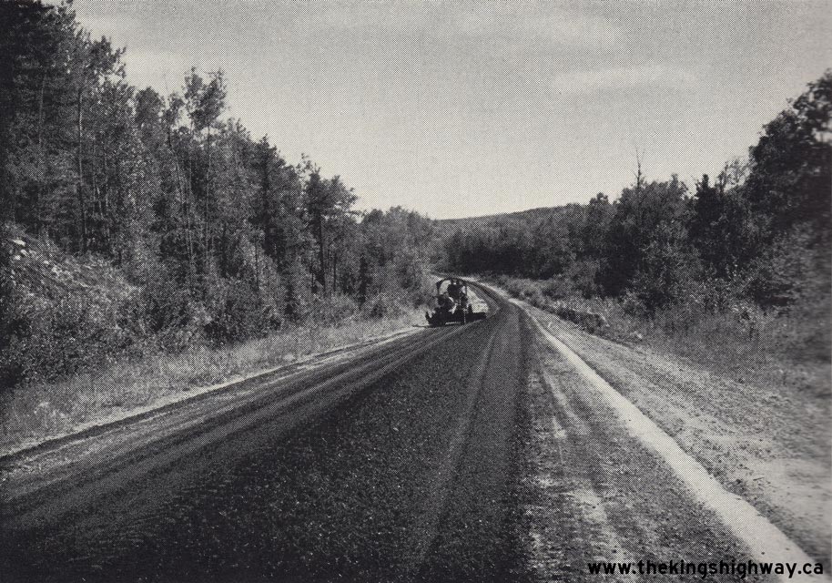
Above - Spreading mulch asphalt on Hwy 70 (today's Hwy 71) south of Nestor Falls. Photo taken on August 1, 1947. (Photo courtesy of Ontario Ministry of Transportation - © King's Printer for Ontario, 1947) 
Left - New asphalt pavement on Hwy 70 (today's Hwy 71), 3 miles north of Nestor Falls. See an
Enlarged Photo Here. Photo taken on July 16, 1949. (Photo courtesy of Ontario Ministry of Transportation - © King's Printer for Ontario, 1949) Right - Early fingerboard guide signs at the Reed Narrows Bridge on Hwy 70 (today's Hwy 71) north of Sioux Narrows in 1949. See an Enlarged Photo Here. (Photo courtesy of Ontario Ministry of Transportation - © King's Printer for Ontario, 1949) 
Above - Circa 1950 view of Hwy 17 approaching the Hwy 70 Junction (today's Hwy 71) at Longbow Corners east of Kenora. This large directional "Y" intersection
was reconfigured many years ago so that Hwy 71 ended at a T-intersection with Hwy 17. However, at the time this photo was taken, traffic had to turn rather sharply to
the left in order to continue east along Hwy 17 towards Dryden. The apparent "through route" at this junction was actually Hwy 70, which began to turn south towards
Sioux Narrows and Fort Frances beyond Longbow Corners. This through route appearance is further amplified by the highway's surface - note that Hwy 70 was paved with a
marked centreline through the highway junction. Observers may notice that the pavement ends on Hwy 17 just beyond the split, where it becomes a gravel-surfaced
highway. It wasn't until the early 1960s that an asphalt pavement was completed along Hwy 17 east of Longbow Corners. See an
Enlarged Photo Here. Photo taken circa 1950. (Photo from Cameron Bevers' historical photograph collection - Original photographer unknown) 
Above - Aerial view of the timber through truss bridge on Hwy 70 (today's Hwy 71) crossing Sioux Narrows in 1951. See an
Enlarged Photo Here. (Photo courtesy of Ontario Ministry of Transportation - © King's Printer for Ontario, 1951) 
Above - Aerial view of Hwy 70 (today's Hwy 71) approaching Sioux Narrows from the south in 1951. See an
Enlarged Photo Here. (Photo courtesy of Ontario Ministry of Transportation - © King's Printer for Ontario, 1951) 
Above - Facing north along Hwy 70 (today's Hwy 71) showing new zone painting approaching the Rushing River Bridge south of Longbow Corners. Photo taken on
August 27, 1953. (Photo courtesy of Ontario Ministry of Transportation - © King's Printer for Ontario, 1953) 
Above - Postcard view of Hwy 70 (today's Hwy 71) approaching Sioux Narrows in 1953. See an
Enlarged Photo Here. (Photo courtesy of Alex Wilson Publishing, Dryden) 
Above - Junction of Hwy 17 & Hwy 70 (today's Hwy 71) at Longbow Corners, facing west towards Kenora. See an
Enlarged Photo Here. Photo taken on September 13, 1955. (Photo courtesy of Ontario Ministry of Transportation - © King's Printer for Ontario, 1955) 
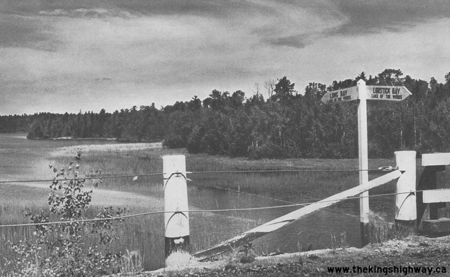
Above - View of Lake of the Woods from Hwy 70 (today's Hwy 71) at Nestor Falls in 1955. See an
Enlarged Photo Here. Photo taken on September 15, 1955. (Photo courtesy of Ontario Ministry of Transportation - © King's Printer for Ontario, 1955) 
Above - Granular base on Hwy 70 (today's Hwy 71) south of Longbow Corners at Sta. 175+00, Contract #1955-51. Photo taken on September 15, 1955. (Photo courtesy of Ontario Ministry of Transportation - © King's Printer for Ontario, 1955) 
Above - Circa 1955 view of Hwy 70 approaching the Hwy 71 Junction between Emo and Rainy River, facing south. This photo provides a rare view of the original
highway junction between Hwy 70 and Hwy 71, prior to the route numbering changes of 1960. That year, an extensive highway renumbering plan was carried out in
Northwestern Ontario, under which Hwy 11 was extended westerly from Nipigon to Rainy River. The entire route of Hwy 120 from Shabaqua Corners to Atikokan and a
portion of Hwy 71 were supplanted by the Hwy 11 designation. In turn, Hwy 70 was renumbered as Hwy 71. Today, this highway junction can be found where Hwy 71 and
Hwy 11 meet just west of Emo. See an Enlarged Photo Here. Photo taken circa 1955. (Photo from Cameron Bevers' historical photograph collection - Original photographer unknown) 
Above - View of Lake of the Woods from Hwy 70 (today's Hwy 71) at Nestor Falls. See an
Enlarged Photo Here. Photo taken in September 1959. (Photo courtesy of Ontario Ministry of Transportation - © King's Printer for Ontario, 1959)
More King's Highway 70 (#1) Photographs Coming Soon!
|
|---|
Links to Adjacent King's Highway Photograph Pages:
Back to King's Highway 69 Photos /
King's Highway 70 (#1) History /
On to King's Highway 70 (#2) Photos
Ontario Highway History - Main Menu / Back to List of Highways Website contents, photos & text © 2002-2026, Cameron
Bevers (Webmaster) - All Rights Reserved / Contact Me
|
|---|