
| 
|  |
|
|
This page contains historical photos of Ontario's King's Highway 7 dating from 1980 to 1989. All photographs displayed on
this page were taken by the Ontario Ministry of Transportation, unless specifically noted otherwise. Historical photographs are arranged in approximate chronological
order. Click on any thumbnail to see a larger image!
Please note that all photographs displayed on this
website are protected by copyright. These photographs must not be reproduced, published,
electronically stored or copied, distributed, or posted onto other websites without
my written permission. If you want to use photos from this website, please
email me first for permission. Thank-you!
|
|---|
|
Page 4: Historical King's Highway 7 Photographs (1980-1989)
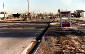
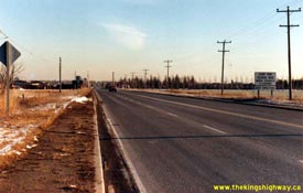
Left - Facing south along Hwy 7 & Hwy 10 (Hurontario Street), about 2 km north of Downtown Brampton in 1980. Although the street hadn't been built yet, the
present-day location of the Williams Parkway intersection lies just beyond the British Petroleum (BP) Service Station in the background of this photo. See an
Enlarged Photo Here. Photo taken on December 5, 1980. (Photo courtesy of Ontario Ministry of Transportation - © King's Printer for Ontario, 2018) Right - View of Hwy 7 & Hwy 10 (Hurontario Street), facing south towards Brampton from Westervelt Corners in 1980. This tiny rural crossroads hamlet, located where today's Bovaird Drive crosses Hurontario Street, has been completely enveloped by the suburban expansion of Brampton over the past few decades. See an Enlarged Photo Here. Photo taken on December 5, 1980. (Photo courtesy of Ontario Ministry of Transportation - © King's Printer for Ontario, 2018) 

Left - Facing north along Hwy 7 & Hwy 10 (Hurontario Street) at Westervelt Corners in 1980. At the traffic signals, Hwy 7 turned left and headed west
towards Georgetown and Guelph, while Hwy 10 continued straight ahead towards Caledon Village and Orangeville. Until 1982, Hwy 7 & Hwy 10 shared a concurrent route
along Hurontario Street between Downtown Brampton and Westervelt Corners. The overlapped route of Hwy 7 & Hwy 10 was discontinued in 1982, when Hwy 7 began to be
signed via Bovaird Drive instead. See an Enlarged Photo Here. Photo taken on December 5, 1980. (Photo courtesy of Ontario Ministry of Transportation - © King's Printer for Ontario, 2018) Right - Facing south along Hwy 10 towards the Hwy 7 West Junction at Westervelt Corners north of Brampton in 1980. In the mid-1950s, the County of Peel built a new truck bypass around Brampton, in an effort to keep heavy vehicles from entering the town centre. The "Brampton Bypass" was known as Peel County Road 16. It followed what is now Bovaird Drive from Hwy 7 & Hwy 10 at Westervelt Corners easterly to Kennedy Road, and then south along Kennedy Road to Hwy 7 East (Queen Street). In preparation for the construction of Hwy 410, the Ministry of Transportation & Communications (MTC) assumed jurisdiction over Heart Lake Road and Bovaird Drive as a provincially-owned truck bypass route in 1974. Even though Hwy 7 itself continued to pass through Downtown Brampton, through traffic was encouraged to use the truck bypass. Although it isn't clear in this photo, a green trailblazer sign in the junction assembly in the background directs traffic bound for Hwy 7 East to turn left and follow Bovaird Drive and Heart Lake Road around Brampton. Soon after this photo was taken, the route of Hwy 7 was relocated from Hurontario Street and Queen Street via Downtown Brampton over to Bovaird Drive and Heart Lake Road (Hwy 410). See an Enlarged Photo Here. Photo taken on December 5, 1980. (Photo courtesy of Ontario Ministry of Transportation - © King's Printer for Ontario, 2018) 
Above - Facing north along Hwy 10 (Hurontario Street) towards Orangeville from the Hwy 7 West Junction at Westervelt Corners. See an
Enlarged Photo Here. Photo taken on December 5, 1980. (Photo courtesy of Ontario Ministry of Transportation - © King's Printer for Ontario, 2018) 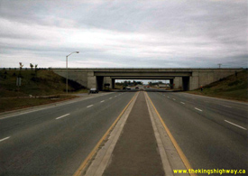

Left - View of the Hwy 7 Interchange on Hwy 404, facing east towards Markham in 1981. This interchange was constructed under Contract #1976-107, which included
the extension of Hwy 404 from Woodbine Avenue & Steeles Avenue northerly to the Hwy 7 Interchange. The Hwy 404 Extension from Woodbine Avenue & Steeles Avenue
to Hwy 7 was completed and opened to traffic in the Fall of 1978. See an Enlarged Photo Here.
Photo taken on September 28, 1981. (Photo courtesy of Ontario Ministry of Transportation - © King's Printer for Ontario, 2023) Right - Facing south along the southbound lanes of Hwy 404 towards Toronto from the Hwy 7 Interchange in 1981. The southbound Hwy 404 structure over Hwy 7 began to carry traffic in 1978, when Hwy 404 was opened from Woodbine Avenue northerly to Hwy 7. Due to construction sequencing, Hwy 404 ended at the Hwy 7 Interchange for nearly 2 years between late 1978 and late 1980. Noticeably absent in this historical 1981 photo is the adjacent Hwy 404 & Hwy 407 ETR Interchange, which wasn't constructed until the mid-1990s. See an Enlarged Photo Here. Photo taken on September 28, 1981. (Photo courtesy of Ontario Ministry of Transportation - © King's Printer for Ontario, 2023) 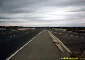

Left - Facing north towards Newmarket along the northbound lanes of Hwy 404 at the Hwy 7 Interchange between Markham and Richmond Hill in 1981. Although this
structure was built in 1976-1977, the northbound bridge sat unopened for several years before it was finally opened to traffic along with the northbound highway lanes
in late 1980. At the time this photo was taken, the section of Hwy 404 lying north of Hwy 7 had only been open to traffic for about 10 months. See an
Enlarged Photo Here. Photo taken on September 28, 1981. (Photo courtesy of Ontario Ministry of Transportation - © King's Printer for Ontario, 2023) Right - Facing west towards Richmond Hill at the Hwy 404 & Hwy 7 Interchange in 1981. In the early 1980s, Hwy 7 had a four-lane cross section through this interchange, as it was still very much a rural King's Highway. With increased urbanization and the completion of Hwy 407 ETR a short distance to the south, the province decided to transfer jurisdiction over Hwy 7 between the Hwy 50 Junction at Sunset Corners and the Hwy 404 Interchange in Markham to the Regional Municipality of York, effective June 7, 1997. See an Enlarged Photo Here. Photo taken on September 28, 1981. (Photo courtesy of Ontario Ministry of Transportation - © King's Printer for Ontario, 2023) 
Above - Eastern side of the southbound Hwy 404 structure over Hwy 7 between Markham and Richmond Hill. See an
Enlarged Photo Here. Photo taken on May 22, 1985. (Photo courtesy of Ontario Ministry of Transportation - © King's Printer for Ontario, 2023) 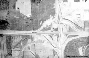
Above - Aerial view of the reconstruction of the Hwy 400 and Hwy 7 Interchange in Vaughan in 1988. The original Hwy 7 Cloverleaf was replaced with a
new interchange and expanded structure in 1987-1988 in order to accommodate the future construction of new ramps to serve the proposed Hwy 407 Interchange. See an
Enlarged Photo Here. (Photo courtesy of Ontario Ministry of Transportation - © King's Printer for Ontario, 2009) 
Above - Aerial view of the new Hwy 7 Diversion east of Concord in 1988. During the 1980s, most of Hwy 7 between Centre Street and Bayview Avenue was
reconstructed as a limited-access expressway. Noticeably absent from this photo is Hwy 407, which was not constructed until the mid-1990s. Note the old
Hwy 7 alignment located between Centre Street and the relocated Hwy 7. See an
Enlarged Photo Here. (Photo courtesy of Ontario Ministry of Transportation - © King's Printer for Ontario, 2009) 
Above - Aerial view of the new Hwy 7 Diversion at the Dufferin Street Interchange in 1988. See an
Enlarged Photo Here. (Photo courtesy of Ontario Ministry of Transportation - © King's Printer for Ontario, 2009) 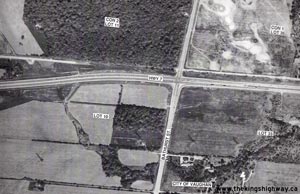
Above - Aerial view of the new Hwy 7 Diversion between the Dufferin Street Interchange and Bathurst Street in 1988. The section of the Hwy 7
Diversion between Bathurst Street and Hwy 11 (Yonge Street) was completed during the early 1960s, over two decades before the remainder of the Hwy 7
Diversion was built in the late 1980s. The Hwy 7 and Bathurst Street junction remained as an at-grade intersection until the 1990s, when the construction
of Hwy 407 necessitated the grade separation of this intersection in order to accommodate the new Hwy 407 Interchange. See an
Enlarged Photo Here. (Photo courtesy of Ontario Ministry of Transportation - © King's Printer for Ontario, 2009) 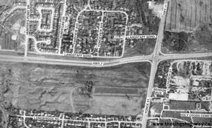
Above - Aerial view of the new Hwy 7 Diversion between Bathurst Street and Yonge Street (Hwy 11) in 1988. This older section of the Hwy 7
Diversion featured a wide grass median, which was typical of Ontario's earlier divided highways. The junction of Hwy 7 and Hwy 11 at Langstaff was
grade separated and reconfigured during the construction of the new Hwy 407 Interchange in the 1990s. See an
Enlarged Photo Here. (Photo courtesy of Ontario Ministry of Transportation - © King's Printer for Ontario, 2009) 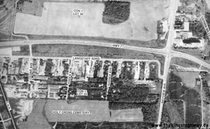
Above - Aerial view of Hwy 7 between Yonge Street (Hwy 11) and Bayview Avenue in 1988. See an
Enlarged Photo Here. (Photo courtesy of Ontario Ministry of Transportation - © King's Printer for Ontario, 2009) 
Above - Aerial view of Hwy 7 between Bayview Avenue and Leslie Street in 1988. See an
Enlarged Photo Here. (Photo courtesy of Ontario Ministry of Transportation - © King's Printer for Ontario, 2009) 
Above - Aerial view of the Hwy 404 & Hwy 7 Interchange near Richmond Hill in 1988. See an
Enlarged Photo Here. (Photo courtesy of Ontario Ministry of Transportation - © King's Printer for Ontario, 2009) 
Above - Aerial view of Hwy 7 between Woodbine Avenue and Warden Avenue in Markham in 1988. See an
Enlarged Photo Here. (Photo courtesy of Ontario Ministry of Transportation - © King's Printer for Ontario, 2009)
Continue on to King's Highway 7 Photos: Historical Photos: 1990 to 1999
|
|---|
Links to Adjacent King's Highway Photograph Pages:
Back to Hwy 7 - Historical Photos (1970-1979)
Hwy 7 Photo Index
On to Hwy 7 - Historical Photos (1990-1999)
Back to King's Highway 6 Photos /
King's Highway 7 History /
On to King's Highway 8 Photos
Ontario Highway History - Main Menu / Back to List of Highways Website contents, photos & text © 2002-2025, Cameron
Bevers (Webmaster) - All Rights Reserved / Contact Me |
|---|