
| 
| |
|
|
This page contains historical photos of Ontario's Queen Elizabeth Way dating from 1932 to 1939. Please note that until 1939,
the Toronto to Burlington section of the Queen Elizabeth Way was called the "Middle Road", and the Burlington to Niagara Falls section of the Queen Elizabeth Way was
known as the "New Niagara Falls Highway". All photographs displayed on this page were taken by the Ontario Ministry of Transportation, unless specifically noted
otherwise. Historical photographs are arranged in approximate chronological order. Click on any thumbnail to see a larger image!
Please note that all photographs displayed on this
website are protected by copyright. These photographs must not be reproduced, published,
electronically stored or copied, distributed, or posted onto other websites without
my written permission. If you want to use photos from this website, please
email me first for permission. Thank-you!
|
|---|
|
Page 1: Historical Queen Elizabeth Way Photographs (1932 to 1939)


Left - New Etobicoke Creek Bridge on the Middle Road (later known as the Queen Elizabeth Way) west of Toronto in 1932, built under Contract #1931-82. The
completion of this bridge allowed traffic to make use of the new four-lane Middle Road between Queen Street in Etobicoke Township and Hwy 10 north of Port Credit. The
highway remained gravel-surfaced for a number of years, before being paved in 1936. The appropriately-named "Middle Road" was situated half-way between the Lakeshore
Highway (Hwy 2) and Dundas Street (Hwy 5). See an Enlarged Photo Here. Photo taken in 1932. (Photo courtesy of Ontario Ministry of Transportation - © King's Printer for Ontario, 1932) Right - Graded four-lane section of the Middle Road in 1934 east of the Credit River Bridge near the Hwy 10 Junction, Contract #1933-45. The Middle Road was extended westerly from Hwy 10 across the Credit River to Mississauga Road in 1933-1934. See an Enlarged Photo Here. Photo taken in 1934. (Photo courtesy of Ontario Ministry of Transportation - © King's Printer for Ontario, 1934) 
Above - Graded Middle Road showing a sodded earth cut east of the Credit River Bridge in 1934, Contract #1933-45. See an
Enlarged Photo Here. Photo taken in 1934. (Photo courtesy of Ontario Ministry of Transportation - © King's Printer for Ontario, 1934) 
Above - Completed Credit River Bridge on the Middle Road near Port Credit in 1934, Contract #1933-48. See an
Enlarged Photo Here. Photo taken in 1934. (Photo courtesy of Ontario Ministry of Transportation - © King's Printer for Ontario, 1934) 

Left - Construction of the new Middle Road Bridge over Sixteen Mile Creek in Oakville, facing east towards Toronto, Contract #1936-57. This was one of two
large open-spandrel concrete deck arch bridges built along the new Middle Road near Oakville during the mid-1930s. Both the Oakville and Bronte Bridges were completed
within days of one another in December 1936. See an Enlarged Photo Here. Photo taken on
September 15, 1936. (Photo © Archives of Ontario - Series RG-14-162-2-27, Cont. B983, Photo #447S) Right - Construction progress on the new Bronte Creek Bridge on the Middle Road, facing northwest, Contract #1936-58. See an Enlarged Photo Here. Photo taken on October 21, 1936. (Photo © Archives of Ontario - Series RG-14-162-2-27, Cont. B983, Photo #505S) 
Above - Aerial view of the Burlington Canadian National Railway (CNR) Subway on the Middle Road & Hwy 25 between Campbell's Corners and Freeman, facing
east towards Toronto. This structure was built in 1936 over the widened dual highway. Note the end of the four-lane divided pavement just east of the subway, which
was constructed under Contract #1936-73. In 1937, this divided concrete pavement was completed between Burlington (Freeman) and Port Credit. This CNR subway still
stands today on a bypassed section of the highway (Plains Road) near the Mapleview Shopping Centre in Burlington. This section of Plains Road used to be a part of the
Queen Elizabeth Way up until 1958, when a new diversion was opened to traffic which provided an improved link to the new Burlington Skyway. See an
Enlarged Photo Here. Photo taken in 1936. (Photo courtesy of Ontario Ministry of Transportation - © King's Printer for Ontario, 1936) 

Left - Construction of the Middle Road near Oakville in 1936. Note the grading for the new second carriageway beside the existing road. Most sections of
the Middle Road were converted from a two-lane road into a four-lane divided highway through a process known as "twinning", whereby a new two-lane road is built
beside an existing two-lane road. While economical, this method of construction along an existing road did lead to some design challenges. Portions of the Middle
Road were already fairly built-up by the 1930s, so private driveways, roadside businesses, intersections and field access points appeared frequently along the
original highway. See an Enlarged Photo Here. Photo taken in 1936. (Photo courtesy of Ontario Ministry of Transportation - © King's Printer for Ontario, 1936) Right - Grading for the dual roadways of the Middle Road near Oakville in 1936. Note the line of trees in the highway's centre boulevard which were deliberately left in place to provide landscaping. See an Enlarged Photo Here. Photo taken in 1936. (Photo courtesy of Ontario Ministry of Transportation - © King's Printer for Ontario, 1936) 
Above - The spectacular Bronte Bridge on the Middle Road, photographed shortly after it was completed in 1936. Note the original Middle Road truss bridge in
the foreground. The new four-lane Middle Road Bridge avoided the steep winding grade leading down to the old bridge. See an
Enlarged Photo Here. Photograph taken on January 15, 1937. (Photo courtesy of Ontario Ministry of Transportation - © King's Printer for Ontario, 1937) 

Left - Completed four-lane concrete pavement on the Middle Road between Oakville and Burlington in 1937. With its garden-like appearance and low traffic
volumes, the Middle Road would have been an absolute delight to drive back in the 1930s. How times have changed since then - Motorists on the congested Queen
Elizabeth Way today would certainly yearn for such a pleasant and soothing drive! Although construction was still underway on a few sections of the highway including
the Port Credit Cloverleaf, the new Middle Road Superhighway was officially opened to traffic in its entirety between Toronto and Burlington on August 27, 1937. See
an Enlarged Photo Here. Photo taken in 1937. (Photo courtesy of Ontario Ministry of Transportation - © King's Printer for Ontario, 1937) Right - Completed four-lane concrete pavement on the Middle Road between Oakville and Burlington in 1937. See an Enlarged Photo Here. Photo taken in 1937. (Photo courtesy of Ontario Ministry of Transportation - © King's Printer for Ontario, 1937) 
Above - Aerial view of the New Niagara Falls Highway Junction on the Middle Road & Hwy 25 near Burlington in 1937, facing northeast. Constructed in 1936,
the Burlington Interchange was actually Ontario's first grade-separated highway interchange. This "trumpet" interchange was fully opened to traffic in the summer of
1937, several months prior to the completion of the more famous Port Credit Cloverleaf west of Toronto. In the late 1950s, the Queen Elizabeth Way was realigned onto
a new diversion around the community of Freeman. The present day location of the Freeman Interchange (Junction of QEW, Hwy 403 & Hwy 407 ETR) can be found at the
extreme upper left corner of this photo. The present day location of the Burlington IKEA store can be found where the farm is situated in the bottom left corner,
while the Mapleview Shopping Centre is located in the upper right corner of this photo. The old interchange was taken out of service gradually starting in 1958. The
last remnants of the old Burlington Interchange were demolished to make way for the construction of the new Fairview Street Interchange in 1984. Note the incredibly
low traffic volumes on the highway during the 1930s! See an Enlarged Photo Here. Photo taken in
1937. (Photo courtesy of Ontario Ministry of Transportation - © King's Printer for Ontario, 1937) 

Left - Completed Sixteen Mile Creek (Oakville) Bridge on the Middle Road in Oakville, facing west towards Burlington. The Middle Road narrowed from a dual
highway to a single 40-foot pavement on the approaches to the Etobicoke, Credit, Bronte and Oakville Bridges. For many years, there was no centre median barrier
separating the two directions of traffic across these four bridges. See an Enlarged Photo Here.
Photo taken in 1937. (Photo courtesy of Ontario Ministry of Transportation - © King's Printer for Ontario, 1937) Right - View of the Middle Road & Hwy 25 at the Burlington Interchange in 1937, facing east towards Toronto. While highway overpasses and interchanges are ubiquitous in today's landscapes, these were very novel concepts during the 1930s and became quite the curiosity for people at the time. A photographer captured this interesting angled perspective of the Burlington Overpass, where the Middle Road & Hwy 25 intersected with the Burlington leg of the New Niagara Falls Highway. Just beyond the structure, traffic could turn right onto Maple Avenue, which entered Burlington's town centre. See an Enlarged Photo Here. Photo taken in 1937. (Photo courtesy of Photographic Arts) 

Left - A four-lane divided section of the Middle Road west of Port Credit, showing trees and utility poles left standing in the centre boulevard. When the
Middle Road was expanded from two to four lanes during the 1930s, all efforts were made to preserve trees lying within the new centre boulevard. The utility poles in
the highway's median were eventually relocated to the outside of the highway once a new highway illumination system was installed. See an
Enlarged Photo Here. Photo taken on July 10, 1937. (Photo © Archives of Ontario - Series RG-14-162-2, Box B983, Photo #1250S) Right - Facing west along the Middle Road towards Etobicoke Creek from Brown's Line (Hwy 27) in 1937. This interesting photo shows the newly-paved Middle Road with a narrow centre boulevard. Even in the 1930s, the Middle Road was already quite developed between Toronto and Port Credit. Engineers were forced to design the highway with no median strip in some places or implement a narrow centre boulevard with a width of only 5 feet, as was the case here. See an Enlarged Photo Here. Photo taken on August 13, 1937. (Photo © Archives of Ontario - Series RG-14-162-2, Box B983, Photo #1281S) 

Left - View of the Middle Road facing east towards Toronto from Brown's Line (Hwy 27) in 1937. This photo shows the general vicinity of the Middle Road near
the end of Queen Street (today's Queensway) in Etobicoke Township. The gravel road intersecting the Middle Road in the foreground is Hwy 27 and the house in the
background is the present-day location of the Queensway & East Mall intersection. Toronto-bound traffic arriving at the eastern terminus of the Middle Road near
Brown's Line initially had to utilize Queen Street to access the city centre. A new four-lane freeway was completed between Brown's Line and the western entrance to
Toronto in 1940. See an Enlarged Photo Here. Photo taken on August 13, 1937. (Photo © Archives of Ontario - Series RG-14-162-2-27, Box B983, Photo #1279S) Right - Facing east towards the Etobicoke Creek Bridge on the Middle Road, east of Dixie Road in 1937. This photo shows the last undivided portion of the Middle Road east of Port Credit, before the centre median was added. The Middle Road between Brown's Line and Port Credit was originally designed in 1931 as a four-lane undivided highway. It was later decided that a centre median should be added to separate the traffic flow and restrict left turns in order to improve highway safety. All newer portions of the Middle Road built in 1936 or later were designed with a centre median, but those sections that were designed between 1931 and 1935 had the centre median added years after the road was completed and opened to traffic. See an Enlarged Photo Here. Photo taken on September 10, 1937. (Photo © Archives of Ontario - Series RG-14-162-2, Box B983, Photo #1411S) 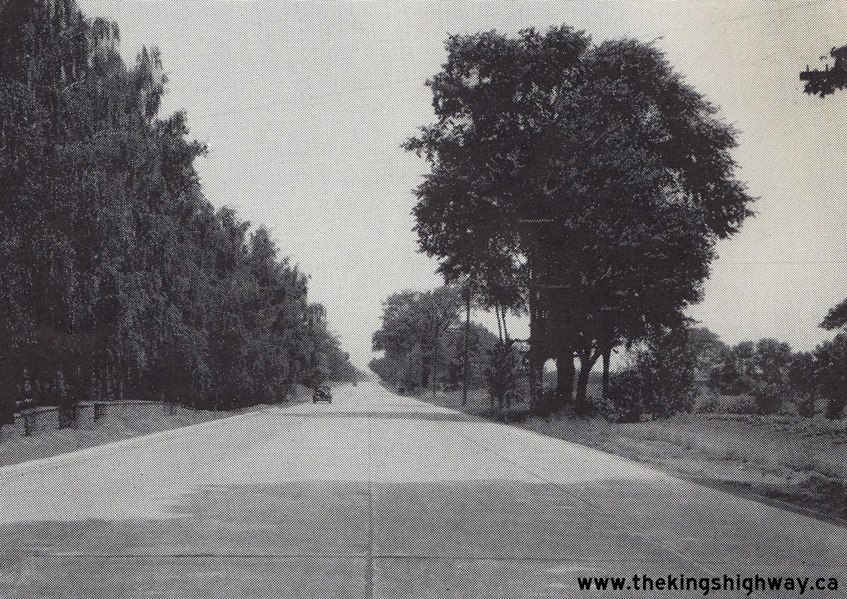

Left - Undivided four-lane pavement on the Middle Road near Dixie Road in 1937. Due to the narrow highway right-of-way east of Port Credit, approximately two
miles of the Middle Road in the vicinity of Dixie Road was constructed with a single 40-foot pavement, rather than as a dual carriageway. See an
Enlarged Photo Here. Photo taken in 1937. (Photo courtesy of Ontario Ministry of Transportation - © King's Printer for Ontario, 1937) Right - Artistic rendering of the proposed Port Credit Cloverleaf at the Middle Road and Hwy 10 from 1937. Engineers with the Department of Highways of Ontario (DHO) studied Germany's rapidly-developing autobahn system in the late 1930s, with considerable attention to the details. In a 1938 editorial, Deputy Highways Minister R.M. Smith noted that left turns of any kind were prohibited along the autobahn system and that access to the new superhighways was controlled via grade-separated interchanges placed adjacent to major centres only. Ontario's legislative framework in the 1930s did not have any provisions that enabled the DHO to designate a "Controlled-Access Highway", but steps were nevertheless taken by the Department to deny private access to the new Middle Road Superhighway wherever possible. The Port Credit Cloverleaf was designed with full access control in mind, which set the stage for the development of Ontario's 400-Series Highways in the decades to come. The cloverleaf at Port Credit was envisioned by Alfred V. Hall, with Arthur N. Martin credited as the creator of this artistic rendering. See an Enlarged Photo Here. (Photo courtesy of Ontario Ministry of Transportation - © King's Printer for Ontario, 1937) 

Left - New Niagara Falls Highway facing east towards Burlington Beach from the Middle Road & Hwy 25 Junction. See an
Enlarged Photo Here. Photo taken in 1937. (Photo courtesy of Ontario Ministry of Transportation - © King's Printer for Ontario, 1937) Right - View of the completed Sheridan Diversion on the Middle Road, facing east towards Port Credit in 1937. As the new Middle Road was extended westerly from Port Credit to Oakville during the 1930s, one section of the new superhighway was built on an entirely new alignment. At Shook's Hill, motorists could either continue west along the "Upper" Middle Road or turn south to Clarkson and follow the "Lower" Middle Road to Oakville. The Sheridan Diversion provided a much shorter cut-off route between the Upper and Lower Middle Roads. As originally designed in 1934, the Sheridan Diversion was graded in such a way to accommodate a 40-foot undivided concrete pavement. When the highway's pavement was being laid out for construction, a decision was made to widen the platform to accommodate a dual highway. Since there were few constraints for engineers to design around along the Sheridan Diversion, it was possible to provide a 30-foot centre boulevard between the two concrete roadways. See an Enlarged Photo Here. Photo taken on October 21, 1937. (Photo courtesy of Ontario Ministry of Transportation - © King's Printer for Ontario, 1937) 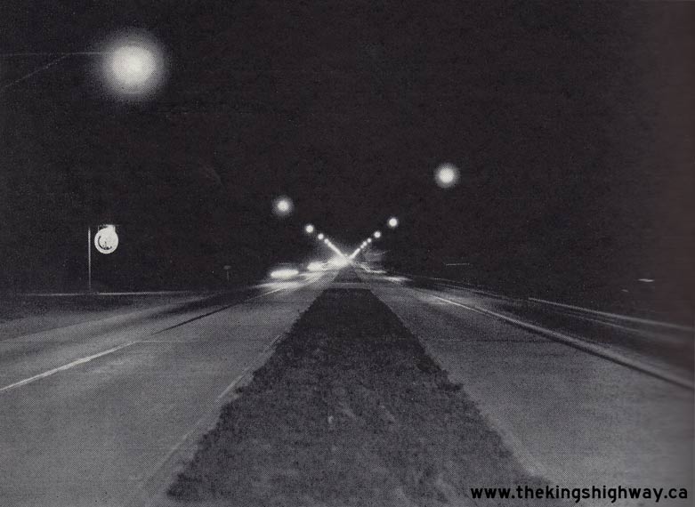

Left - Nighttime photo of the completed Middle Road in 1937, showing the new High-Pressure Sodium (HPS) illumination system. Highway illumination was installed
along a 4-mile section of the Middle Road between Toronto and Port Credit in 1937. See an
Enlarged Photo Here. Photo taken in 1937. (Photo courtesy of Ontario Ministry of Transportation - © King's Printer for Ontario, 1937) Right - New plantings in the centre boulevard of the Middle Road between Oakville and Burlington in 1938. In areas where trees could not be saved during construction of the new dual highway, the DHO planted new shrubs and trees to replace those lost during construction. With a vision of developing a scenic parkway between Toronto and Niagara Falls, boulevard landscaping and overall highway beautification was of utmost importance for the DHO. See an Enlarged Photo Here. Photo taken on August 22, 1938. (Photo courtesy of Ontario Ministry of Transportation - © King's Printer for Ontario, 1938) 
Left - Artistic rendering of the proposed high-level bridge over the Burlington Canal at the entrance to Hamilton Harbour from 1937. With construction of the
New Niagara Falls Highway well underway by late 1937, the DHO began to consider design alternatives to continue the new dual highway across the Burlington Canal. In
November 1937, drawings for two design options were prepared by DHO engineers. Both structure alternatives were of the same length - 6,952 feet, or just under 2.2 km
of elevated highway structure. This length excluded the 800-foot approach fills anticipated on either side of the structure. The crossing alternatives both consisted
of a structure width of 64 feet, including a four-lane dual highway with 11-foot traffic lanes, a 6-foot centre median, and two 7-foot sidewalks on either side. The
bridge structure itself consisted of a main steel cantilevered arch through truss with a span of 400 feet, flanked by 7 deck truss spans on either side with a length
of 250 feet each, 4 additional steel spans with a length of 187 feet, 6 inches and 6 steel spans with a length of 125 feet each. The remaining crossing distance was
comprised of large ornamental concrete "gateway" pedestals on either side of the main arch. The only difference between the two alternatives was the vertical
clearance over the navigational channel below, which was 150 feet using a 3 percent approach grade or 180 feet using a 4 percent approach grade. Due to other pressing
highway construction priorities, the high-level Burlington Canal Bridge remained on engineers' drawing boards at the outbreak of World War II in 1939. Due to the
severe Post-War shortages of structural steel, construction didn't start on the new Burlington Bay Skyway until the mid-1950s. The new structure finally opened to
traffic on October 30, 1958, more than 20 years after this artistic rendering was prepared. See an
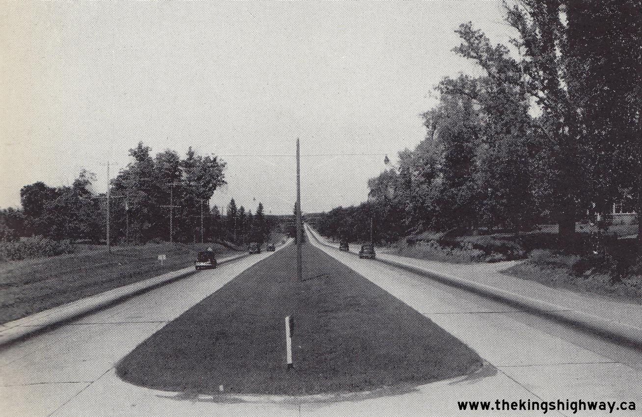
Enlarged Photo Here. (Photo courtesy of Ontario Ministry of Transportation - © King's Printer for Ontario, 1937) Right - View of the Middle Road between Port Credit and Oakville in 1938, facing east from Shook's Hill near Sheridan. See an Enlarged Photo Here. Photo taken in 1938. (Photo courtesy of Ontario Ministry of Transportation - © King's Printer for Ontario, 1938) 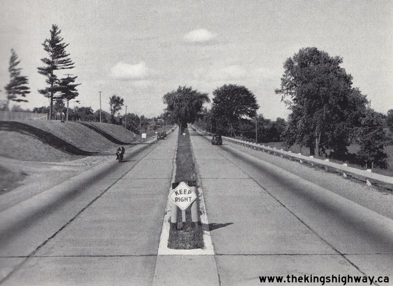

Left - Facing east along the Middle Road towards Oakville from the Bronte Bridge. See an
Enlarged Photo Here. Photo taken in 1938. (Photo courtesy of Ontario Ministry of Transportation - © King's Printer for Ontario, 1938) Right - New highway illumination system along the Middle Road west of Clarkson Side Road in 1938, facing east towards Toronto. See an Enlarged Photo Here. Photo taken in 1938. (Photo courtesy of Ontario Ministry of Transportation - © King's Printer for Ontario, 1938) 

Left - Completed grading and overpasses at Grimsby on the New Niagara Falls Highway in 1938. Construction began in 1937 on a new dual highway between Stoney
Creek and Niagara Falls. The gravel-surfaced dual highway was opened to traffic between Stoney Creek and Jordan Road in 1938. See an
Enlarged Photo Here. Photo taken in 1938. (Photo courtesy of Ontario Ministry of Transportation - © King's Printer for Ontario, 1938) Right - Approaching the Port Credit Cloverleaf at Hwy 10 and the Middle Road, facing east towards Toronto. The Port Credit Cloverleaf was the first full cloverleaf interchange ever built in Canada. Tenders were called by the DHO in March 1937 for the construction of the new cloverleaf, under Contract #1937-71. The Port Credit Cloverleaf was officially opened to traffic 8 months later on November 21, 1937. See an Enlarged Photo Here. Photo taken on August 22, 1938. (Photo courtesy of Ontario Ministry of Transportation - © King's Printer for Ontario, 1938) 
Above - Facing west along the Middle Road towards Hamilton from the Hwy 10 Overpass at the new Port Credit Cloverleaf in 1938. See an
Enlarged Photo Here. Photo taken in 1938. (Photo courtesy of Ontario Ministry of Transportation - © King's Printer for Ontario, 1938) 

Left - New highway lighting along the Middle Road at night just east of Oakville. See an
Enlarged Photo Here. Photo taken in 1938. (Photo courtesy of Ontario Ministry of Transportation - © King's Printer for Ontario, 1938) Right - DHO crew installing new light fixtures on the Middle Road's new highway illumination system. See an Enlarged Photo Here. Photo taken in 1938. (Photo courtesy of Ontario Ministry of Transportation - © King's Printer for Ontario, 1938) 
Above - Night view of the Port Credit Cloverleaf at Hwy 10 and the Middle Road in 1938, showing the new High-Pressure Sodium (HPS) illumination system at
Canada's first grade-separated full cloverleaf interchange. Illumination was installed at the Port Credit and Burlington Interchanges in 1937, along with a 4-mile
section of the Middle Road between Toronto and Port Credit. A continuous illumination system was installed along the entire length of the dual highway between Toronto
and Niagara Falls by 1941. See an Enlarged Photo Here. Photo taken in 1938. (Photo courtesy of Ontario Ministry of Transportation - © King's Printer for Ontario, 1938) 

Left - Henley Course Bridge under construction facing east from the west bank, Contract #1938-27. See an
Enlarged Photo Here. Photo taken on October 12, 1938. (Photo courtesy of Ontario Ministry of Transportation - © King's Printer for Ontario, 1938) Right - View of the Port Credit Cloverleaf at Middle Road (Queen Elizabeth Way) and Hwy 10 in 1938, facing northwest. See an Enlarged Photo Here. Photo taken on December 10, 1938. (Photo courtesy of Ontario Ministry of Transportation - © King's Printer for Ontario, 1938) 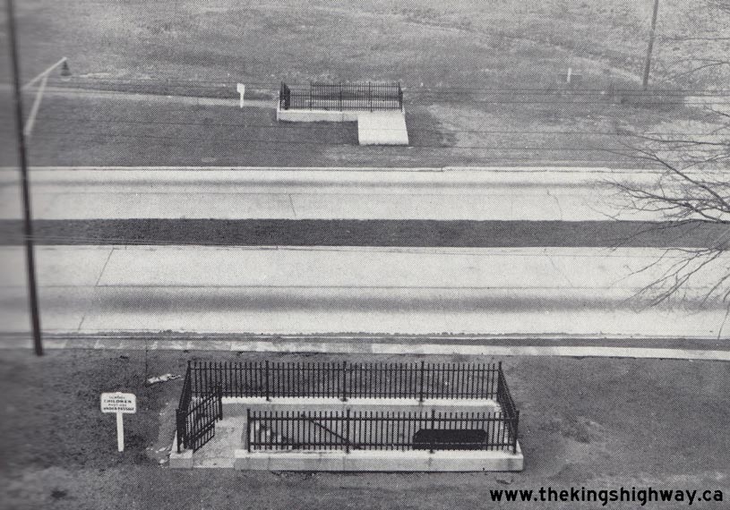

Left - Underpass for school children below the Middle Road near the Hwy 10 Cloverleaf at Port Credit. See an
Enlarged Photo Here. Photo taken on December 10, 1938. (Photo courtesy of Ontario Ministry of Transportation - © King's Printer for Ontario, 1938) Right - Plan from 1939 for the proposed Niagara Street Interchange along the Queen Elizabeth Way in St. Catharines. See an Enlarged Photo Here. (Photo courtesy of Ontario Ministry of Transportation - © King's Printer for Ontario, 1939) 


Left - Route map of the Middle Road from 1939, showing the new dual highway between Toronto and Burlington. See an
Enlarged Photo Here. (Photo courtesy of Ontario Ministry of Transportation - © King's Printer for Ontario, 1939) Centre - Completed ornamental stonework for the Henley Course Bridge, photographed in the sculptor's studio in 1939 prior to installation in St. Catharines. See an Enlarged Photo Here. Photo taken in 1939. (Photo courtesy of Ontario Ministry of Transportation - © King's Printer for Ontario, 1939) Right - Details of the ornamental stonework for the new Henley Course Bridge in 1939. See an Enlarged Photo Here. Photo taken in 1939. (Photo courtesy of Ontario Ministry of Transportation - © King's Printer for Ontario, 1939) 
Above - View of the Middle Road Superhighway facing west towards Hamilton from the Hwy 10 Cloverleaf at Port Credit in 1939. This fantastic centreline photo of
the new superhighway was taken about 18 months after the Port Credit Cloverleaf was completed and opened to traffic on November 21, 1937. The cloverleaf carried
Hwy 10 traffic safely across the Middle Road. This was the first cloverleaf interchange ever built in Canada. Very few jurisdictions had ever built a high-speed
motorway when this cloverleaf was designed in 1937, and that lack of design experience led to problems with the interchange that, in hindsight, one might view as
obvious. Note that ramp traffic had to stop and wait at the end of the ramps for gaps in traffic before entering the superhighway, as there were no speed change lanes
beyond the ramp entrances. It was assumed (perhaps naively) that motorists would be courteous enough to allow entering traffic to merge and that traffic volumes would
remain low enough that lane changes could take place easily. However, as this photo clearly demonstrates, the superhighway was already getting quite busy even before
World War II. This photo wasn't taken on a weekday either - it was taken on a Sunday evening! Three days after this photo was taken, the Middle Road was officially
rededicated as the "Queen Elizabeth Way". See an Enlarged Photo Here. Photo taken on June 4,
1939. (Photo © Archives of Ontario - Series RG-14-162-3, Cont. A1352, Photo #113B) 
Above - Their Majesties King George VI & Queen Elizabeth (The Queen Mother) in the Royal Motorcade at the Queen Elizabeth Way Dedication Ceremonies in
St. Catharines in 1939. See an Enlarged Photo Here. Photo taken on June 7, 1939. (Photo courtesy of Ontario Ministry of Transportation - © King's Printer for Ontario, 1939) 

Left - Queen Elizabeth Way Dedication Ceremonies in St. Catharines. See an
Enlarged Photo Here. Photo taken on June 7, 1939. (Photo courtesy of Ontario Ministry of Transportation - © King's Printer for Ontario, 1939) Right - Queen Elizabeth Way Dedication Ceremonies in St. Catharines. See an Enlarged Photo Here. Photo taken on June 7, 1939. (Photo courtesy of Ontario Ministry of Transportation - © King's Printer for Ontario, 1939) 
Above - An artist's early concept sketch of the new Toronto Entrance on the Queen Elizabeth Way from 1939. See an
Enlarged Photo Here. (Photo courtesy of Ontario Ministry of Transportation - © King's Printer for Ontario, 1939) 

Left - New Church Street Overpass (Royal York Road) on the Queen Elizabeth Way in Etobicoke Township. See an
Enlarged Photo Here. Photo taken on August 17, 1939. (Photo courtesy of Ontario Ministry of Transportation - © King's Printer for Ontario, 1939) Right - Looking east along the graded lanes of the Queen Elizabeth Way at Jordan Harbour. See an Enlarged Photo Here. Photo taken on September 21, 1939. (Photo courtesy of Ontario Ministry of Transportation - © King's Printer for Ontario, 1939) 

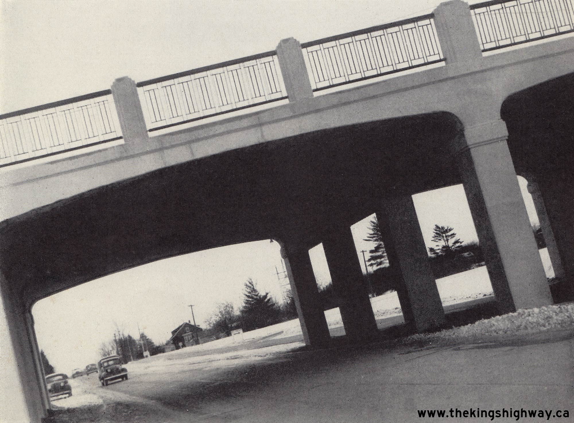
Left - Facing east along the Queen Elizabeth Way towards the Martindale Road Overpass and Henley Course Bridge in 1939. This great historic photo shows the new
grade separation at Martindale Road virtually completed, with some work taking place along the semi-cloverleaf ramps and the paved concrete roadways of the Queen
Elizabeth Way below the structure. Paving of the Queen Elizabeth Way was completed from just west of Martindale Road to Ontario Street before winter set in. The rest
of the highway from Stoney Creek to Niagara Falls was paved in 1940. See an
Enlarged Photo Here. Photo taken on September 21, 1939. (Photo © Archives of Ontario - Series RG-14-162-2-27, Box B983, Photo #2337S) Right - Completed dual highway bridges on the Queen Elizabeth Way at Sixteen Mile Creek west of St. Catharines, Contract #1938-26. See an Enlarged Photo Here. Photo taken on September 21, 1939. (Photo courtesy of Ontario Ministry of Transportation - © King's Printer for Ontario, 1939) 
Left - View of the completed Henley Course Bridge on the Queen Elizabeth Way in St. Catharines. See an
Enlarged Photo Here. Photo taken on November 22, 1939. (Photo courtesy of Ontario Ministry of Transportation - © King's Printer for Ontario, 1939) Right - Looking east along the Queen Elizabeth Way towards the completed Patton & Ontario Street Overpasses in Grimsby in 1939. Note the small sign to the right of the highway, which reads "Next Turn Right Grimsby". Early Ontario highway signs tended to be quite "wordy", since engineers at that time did not fully understand about how motorists interpreted highway signs. As more research was done with respect to highway sign legibility and comprehension by motorists, graphics began to supplant many commonly-used words on our early highway signs. This sign was ultimately replaced with a more simplified sign, which just ready "Grimsby" with a right-pointing arrow. See an Enlarged Photo Here. Photo taken on November 22, 1939. (Photo © Archives of Ontario - Series RG-14-162-2-27, Box B983, Photo #2465S) 

Left - Graded Queen Elizabeth Way at Jordan Harbour west of St. Catharines, facing west towards Grimsby. See an
Enlarged Photo Here. Photo taken on November 22, 1939. (Photo © Archives of Ontario - Series RG-14-162-2-27, Box B983, Photo #2467S) Right - Completed Kipling Avenue Overpass on the Queen Elizabeth Way in Etobicoke Township, Contract #1938-49. See an Enlarged Photo Here. Photo taken on November 25, 1939. (Photo courtesy of Ontario Ministry of Transportation - © King's Printer for Ontario, 1939) 

Left - View of the completed Henley Course Bridge on the Queen Elizabeth Way in St. Catharines with ornamental stonework installed, Contract #1938-27. See an
Enlarged Photo Here. Photo taken on November 23, 1939. (Photo courtesy of Ontario Ministry of Transportation - © King's Printer for Ontario, 1939) Right - Completed Henley Course Bridge on the Queen Elizabeth Way near St. Catharines, showing the open spandrel concrete deck arch superstructure. This was the first major bridge built along the Queen Elizabeth Way to feature a dual structure configuration to separate the two directions of traffic. The Etobicoke, Credit, Oakville and Bronte Bridges were originally built with a single 40-foot pavement across the structures, with an "hourglass" configuration on either side where the dual highway converged into a single roadway on the bridge approaches. Shortly after the Middle Road fully opened to traffic in 1937, the DHO observed that some motorists used these short undivided highway sections at bridges as a passing opportunity. Motorists stuck behind two slower vehicles on the dual highway would sometimes pull out into the opposing traffic lanes and drive three abreast once the dual highway ended before the bridge. Motorists who attempted these passing manoeuvres has very little time to get around the slower vehicles and cut back over before the dual highway resumed again on the other side. In order to prevent this from happening, the DHO mandated in 1938 that all new divided highways in Ontario would be built with two separated carriageways across bridges. See an Enlarged Photo Here. Photo taken on November 23, 1939. (Photo courtesy of Ontario Ministry of Transportation - © King's Printer for Ontario, 1939) 
Above - Ornamental stonework on the completed Henley Course Bridge in 1939. See an
Enlarged Photo Here. Photo taken on November 23, 1939. (Photo courtesy of Ontario Ministry of Transportation - © King's Printer for Ontario, 1939) 

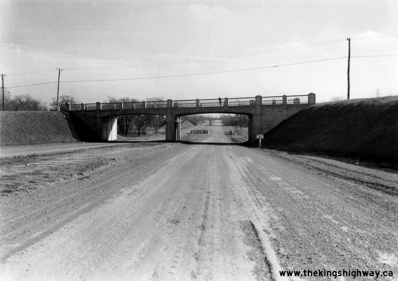
Left - New Canadian Pacific Railway (CPR) Overhead under construction on the Queen Elizabeth Way near Kipling Avenue in Etobicoke Township, Contract #1938-49.
See an Enlarged Photo Here. Photo taken on November 25, 1939. (Photo courtesy of Ontario Ministry of Transportation - © King's Printer for Ontario, 1939) Right - Queen Elizabeth Way at the Hwy 8 Junction at Homer, looking west from the Homer Lift Bridge in 1939. This photo shows the graded Queen Elizabeth Way roadways, facing west from the old Homer lift bridge. The Cushman Road Underpass can be seen on the Queen Elizabeth Way in the background. This portion of the Queen Elizabeth Way was bypassed in 1963, when the Garden City Skyway opened to traffic just a short distance to the north. In this photo, detour signs are in place at the junction to encourage through traffic to utilize Hwy 8 instead of the Queen Elizabeth Way, which was not fully completed at the time. Back in the 1930s and 1940s, little attempt was made to barricade roads which were under construction. Consequently, motorists would frequently drive upon newly-built roads months (and in some cases, years) before the highway was officially "opened" to traffic. Today, engineers with the Ministry of Transportation conduct a very thorough inspection of a newly-built highway before allowing any traffic to use it. See an Enlarged Photo Here. Photo taken on November 29, 1939. (Photo © Archives of Ontario - Series RG-14-162-2-27, Box B983, Photo #2519S) 

Left - Facing west along the Queen Elizabeth Way towards the Grimsby Beach Road (later Park Road) Overpass in 1939. This grade-separation was one of four
highway overpasses built along the Queen Elizabeth Way through Grimsby in 1938. A diamond interchange was eventually built at Grimsby Beach Road, as part of an effort
to improve highway access points within Grimsby. The Grimsby Beach Road Overpass was replaced with a new underpass and interchange at nearby Bartlett Avenue in
1972-1973. As part of this reconstruction contract, the old bridge seen here was back-filled and the new highway was built on top of it. See an
Enlarged Photo Here. Photo taken on November 29, 1939. (Photo © Archives of Ontario - Series RG-14-162-2-27, Box B983, Photo #2517S) Right - Radial railway and dual highway grade separation on the Queen Elizabeth Way near Lake Street in St. Catharines. See an Enlarged Photo Here. Photo taken on November 29, 1939. (Photo courtesy of Ontario Ministry of Transportation - © King's Printer for Ontario, 1939)
Continue on to Queen Elizabeth Way Historical Photos from 1940-1949
|
|---|
Links to Adjacent King's Highway Photograph Pages:
Back to King's Highway 427 Photos /
Queen Elizabeth Way History /
On to Secondary Highway 500 Photos
Ontario Highway History - Main Menu / Back to List of Highways Website contents, photos & text © 2002-2026, Cameron
Bevers (Webmaster) - All Rights Reserved / Contact Me
|
|---|