
| 
| |
|
|
This page contains historical photos of Ontario's Queen Elizabeth Way dating from 1940 to 1949. All photographs displayed on
this page were taken by the Ontario Ministry of Transportation, unless specifically noted otherwise. Historical photographs are arranged in approximate chronological
order. Click on any thumbnail to see a larger image!
Please note that all photographs displayed on this
website are protected by copyright. These photographs must not be reproduced, published,
electronically stored or copied, distributed, or posted onto other websites without
my written permission. If you want to use photos from this website, please
email me first for permission. Thank-you!
|
|---|
|
Page 2: Historical Queen Elizabeth Way Photographs (1940 to 1949)

Above - Elizabeth Regina "ER" Highway Sign on the Queen Elizabeth Way at the Sheridan Diversion northeast of Oakville in 1940. These special "ER" highway signs
were in use from the highway's initial dedication in 1939 up until the mid-1950s, when they were replaced with the more familiar "QEW" route markers which are still
in use along the highway to this day. Fellow highway enthusiast Eric Vettoretti was kind enough to share this photo from his collection,
showing the colour scheme used for these early Queen Elizabeth Way route markers. See an
Enlarged Photo Here. Photo taken on February 20, 1940. (Photo © Archives of Ontario - Series RG-14-162-3, Box A1352, Photo #2617S) 
Above - Plan showing the new route of the Queen Elizabeth Way from Toronto to Fort Erie in 1940. See an
Enlarged Photo Here. (Photo courtesy of Ontario Ministry of Transportation - © King's Printer for Ontario, 1940) 

Left - Construction progress on the new Canadian National Railway (CNR) Overhead on the Queen Elizabeth Way at the western entrance to Toronto. This impressive
multi-span structure was built under Contracts #1939-101 (concrete work) and #1939-102 (structural steel). See an
Enlarged Photo Here. Photo taken on April 1, 1940. (Photo courtesy of Ontario Ministry of Transportation - © King's Printer for Ontario, 1940) Right - Concrete paving operations underway on the Queen Elizabeth Way near Grimsby in 1940. The entire section of the highway from the Stoney Creek Traffic Circle to the Henley Bridge in St. Catharines was paved under a very aggressive 10-week construction timeline. The goal was to have the new Niagara leg of the Queen Elizabeth Way ready for service before the start of the 1940 Canadian National Exhibition (CNE) in Toronto. See an Enlarged Photo Here. Photo taken on June 21, 1940. (Photo courtesy of Ontario Ministry of Transportation - © King's Printer for Ontario, 1940) 

Left - Night paving operations on the Queen Elizabeth Way in 1940. In order to complete paving in time for the opening of the 1940 CNE in Toronto, construction
crews worked 24 hours per day on various paving contracts along the Queen Elizabeth Way up and down the Niagara Peninsula. The CNE attracted thousands of American
motorists each summer. Prior to the completion of the Niagara leg of the Queen Elizabeth Way, the sheer volume of tourists heading to the CNE contributed to
serious traffic tie-ups along Hwy 8 between Niagara Falls and Hamilton. See an
Enlarged Photo Here. Photo taken on June 21, 1940. (Photo courtesy of Ontario Ministry of Transportation - © King's Printer for Ontario, 1940) Right - Labourers using brooms to apply an anti-skid texture to the new concrete surface of the Queen Elizabeth Way near Grimsby. See an Enlarged Photo Here. Photo taken on June 21, 1940. (Photo courtesy of Ontario Ministry of Transportation - © King's Printer for Ontario, 1940) 

Left - Concrete spreader in operation near Grimsby during paving of the Queen Elizabeth Way. See an
Enlarged Photo Here. Photo taken on June 21, 1940. (Photo courtesy of Ontario Ministry of Transportation - © King's Printer for Ontario, 1940) Right - Paving the Queen Elizabeth Way near Grimsby, showing ponding operations to cure the concrete. See an Enlarged Photo Here. Photo taken on June 21, 1940. (Photo courtesy of Ontario Ministry of Transportation - © King's Printer for Ontario, 1940) 

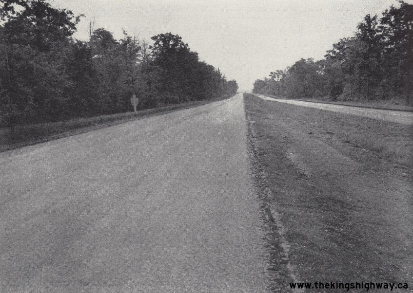
Left - View of the Queen Elizabeth Way west of Guelph Line near Freeman in 1940, facing east towards Oakville. Landscaped medians such as this were once a
common sight along the Queen Elizabeth Way in the highway's earlier days. As traffic volumes along the highway grew after World War II, the old grassed median was
gradually filled in and replaced with a centre median barrier to separate the opposing flows of traffic. See an
Enlarged Photo Here. Photo taken on August 15, 1940. (Photo © Archives of Ontario - Series RG-14-162-2-27, Box B983, Photo #3040S) Right - Facing north along the Queen Elizabeth Way towards the Hwy 2 Junction (today's North Shore Boulevard) from Burlington Beach in 1940. Prior to the construction of the Burlington Skyway in the 1950s, the Queen Elizabeth Way narrowed from a four-lane divided highway to a two-lane undivided pavement approaching the Burlington Canal Lift Bridge on Beach Boulevard. Although a new high-level fixed canal crossing had been envisioned here in the late 1930s, the outbreak of World War II deferred its construction for many years. By the early 1950s, the old lift bridge on Beach Boulevard had become a serious traffic bottleneck. Each time a ship had to pass through the canal, traffic became snarled at each end of the lift bridge. This problem was ultimately resolved with the completion of the Burlington Skyway in October 1958. See an Enlarged Photo Here. Photo taken on August 16, 1940. (Photo © Archives of Ontario - Series RG-14-162-2-27, Box B983, Photo #3043S) 

Left - Queen Elizabeth Way facing east towards the Niagara and Vine Street Cloverleaf in St. Catharines in 1940. This photo shows the completed dual concrete
pavement along the Queen Elizabeth Way, and the new highway illumination system being installed. See an
Enlarged Photo Here. Photo taken on August 21, 1940. (Photo © Archives of Ontario - Series RG-14-162-2-27, Box B983, Photo #3068S) Right - Aerial view of the Martindale Road Cloverleaf on the Queen Elizabeth Way near St. Catharines in 1940. See an Enlarged Photo Here. (Photo © Archives of Ontario - Series RG-14-162-2, Box B983, Photo #3266S) 
Above - Newly-built Queen Elizabeth Way monument at the western entrance to Toronto in 1940. See an
Enlarged Photo Here. (Photo courtesy of Ontario Ministry of Transportation - © King's Printer for Ontario, 1940) 

Left - Ontario Highways Minister Thomas Baker McQuesten cuts a ceremonial ribbon in St. Catharines on August 23, 1940, to officially open the Queen Elizabeth
Way to traffic between Niagara Falls and Toronto. It should be noted that at the time this photo was taken, construction was still ongoing on the extension of the
Queen Elizabeth Way from Niagara Falls to Fort Erie, while several sections of the highway between Toronto and Burlington had already been in service for several
years. See an Enlarged Photo Here. Photo taken on August 23, 1940. (Photo courtesy of Ontario Ministry of Transportation - © King's Printer for Ontario, 1940) Right - Church Street (Royal York Road) Overpass on the Queen Elizabeth Way in Etobicoke Township approaching Toronto. Constructed in 1938, this was the first of several grade separations built to carry local streets over the proposed Toronto Entrance Highway (Queen Elizabeth Way). A 4-mile section of new controlled-access highway was built approaching the western entrance to Toronto between 1938 and 1940. This new controlled-access highway was Ontario's first true freeway. It extended across Etobicoke Township from the Hwy 27 Cloverleaf to the Hwy 2 (Lakeshore Boulevard) Interchange near Mimico. This new freeway had no local access points or entrances whatsoever. Motorists could only enter or exit the Queen Elizabeth Way at the two interchanges at either end of the freeway. This new Toronto Entrance Highway bypassed the old "Middle Road" entrance to Toronto via Queen Street (Queensway). See an Enlarged Photo Here. Photo taken on October 8, 1940. (Photo courtesy of Ontario Ministry of Transportation - © King's Printer for Ontario, 1940) 

Left - Cloverleaf interchange construction at Hwy 27 (Brown's Line) and the Queen Elizabeth Way, facing east towards Toronto in 1940. This photograph shows the
beginning of the new freeway entrance to Toronto, which was built between 1938 and 1940. The freeway extended from Hwy 27 (today's Hwy 427) easterly to Hwy 2 near the
Humber River. The fields in the lower left corner are now the present-day site of the Sherway Gardens Shopping Centre. Evans Avenue can be seen to the right of the
Queen Elizabeth Way, while Queen Street (today's Queensway) can be seen to the left of the Queen Elizabeth Way. Also, note the construction crew at centre left and
upper left removing the old curved pavement of the former Queen Street-to-Middle Road transfer. Before the new western approach to Toronto was built through Etobicoke
Township, the Queen Elizabeth Way simply merged with Queen Street near the present-day intersection of Queensway and The East Mall. Traffic then had to follow Queen
Street all the way into Toronto. The new freeway at the western entrance to Toronto greatly expedited traffic flow into the city centre. See an
Enlarged Photo Here. (Photo © Archives of Ontario - Series RG-14-162-3 Photo #3262S) Right - Facing west along the Queen Elizabeth Way towards Hamilton from the Hwy 27 (Brown's Line) Cloverleaf in Etobicoke Township in 1940. This wonderful photograph shows the newly-completed Hwy 27 Cloverleaf, situated at the present-day location of the multi-level interchange at Hwy 427 and the Queen Elizabeth Way near Sherway Gardens Shopping Centre. Before this cloverleaf was built in 1940, Hwy 27 intersected the Queen Elizabeth Way at an at-grade intersection with traffic signals. Back in the 1940s, the Queen Elizabeth Way passed through a predominantly rural area, with many miles of open country between Toronto, Port Credit, Oakville and Burlington. How times have changed! See an Enlarged Photo Here. Photo taken in 1940. (Photo courtesy of Ontario Ministry of Transportation - © King's Printer for Ontario, 1940) 

Left - View of the Queen Elizabeth Way facing east towards Toronto from the Church Street (Royal York Road) Overpass in 1940. This photograph shows the
newly-opened "freeway" section of the Queen Elizabeth Way through Etobicoke Township. The overpass which can be seen in the background is Grand Avenue. The Department
of Highways of Ontario (DHO) applied the freeway design principle when planning for the new 4-mile Toronto Entrance Highway. All local access points to the freeway
were prohibited, with vehicular access only permitted to the highway at specially-designed grade-separated interchanges. Although the concept of a freeway is a
commonly seen, understood and accepted transportation feature in our present-day world, the freeway was an innovative (and somewhat controversial) idea at the time
this highway was designed in the late 1930s. Ontario was an early adopter of the freeway concept and built many more of these types of highways after World War II.
See an Enlarged Photo Here. Photo taken on October 8, 1940. (Photo © Archives of Ontario - Series RG-14-162-3 Photo #3112S) Right - Rock cut construction on the Rainbow Bridge Approach at Newman Hill near Victoria Avenue in Niagara Falls, Contract #1940-99. See an Enlarged Photo Here. Photo taken in 1940. (Photo courtesy of Ontario Ministry of Transportation - © King's Printer for Ontario, 1940) 
Above - Construction progress on the Rainbow Bridge in Niagara Falls. See an
Enlarged Photo Here. Photo taken in 1940. (Photo courtesy of Ontario Ministry of Transportation - © King's Printer for Ontario, 1940) 

Left - Construction of the Welland River Bridge on the Queen Elizabeth Way south of Niagara Falls, Contract #1939-140. See an
Enlarged Photo Here. Photo taken in 1940. (Photo courtesy of Ontario Ministry of Transportation - © King's Printer for Ontario, 1940) Right - Fort Erie Railway Overhead under construction on the Queen Elizabeth Way, Contract #1939-140. See an Enlarged Photo Here. Photo taken in 1940. (Photo courtesy of Ontario Ministry of Transportation - © King's Printer for Ontario, 1940) 
Above - Winter sanding operations along an icy section of the Queen Elizabeth Way near Port Credit. See an
Enlarged Photo Here. Photo taken in 1940. (Photo courtesy of Ontario Ministry of Transportation - © King's Printer for Ontario, 1940) 

Left - Circa 1940 postcard view of the Canadian entrance to the Peace Bridge in Fort Erie. See an
Enlarged Photo Here. (Photo courtesy of the Photogelatine Engraving Company Ltd, Ottawa) Right - Queen Elizabeth Way at Grimsby, facing east towards St. Catharines from the Patton Street Overpass in 1941. Note the new highway illumination system installed in the highway's median. Once the lighting system was completed in 1940, the Queen Elizabeth Way was continuously illuminated from Toronto to Niagara Falls. However, the hydro supply to the luminaires ultimately had to be turned off during World War II as an energy conservation measure. See an Enlarged Photo Here. Photo taken in 1941. (Photo courtesy of Ontario Ministry of Transportation - © King's Printer for Ontario, 1941) 
Above - Queen Elizabeth Way Monument in the median of the dual highway, just west of Toronto. See an
Enlarged Photo Here. Photo taken in 1941. (Photo courtesy of Ontario Ministry of Transportation - © King's Printer for Ontario, 1941) 

Left - Queen Elizabeth Way Monument at the end of the highway, just west of the Humber River in Toronto. See an
Enlarged Photo Here. Photo taken in 1941. (Photo courtesy of Ontario Ministry of Transportation - © King's Printer for Ontario, 1941) Right - Close-up of the Queen Elizabeth Way Monument west of Toronto in 1941, showing the inscription in the stone. As a result of a highway widening project in the mid-1970s, the monument was moved from its old location in the Queen Elizabeth Way's median to a public park at the mouth of the Humber River in Toronto. See an Enlarged Photo Here. Photo taken in 1941. (Photo courtesy of Ontario Ministry of Transportation - © King's Printer for Ontario, 1941) 
Above - Wartime traffic volumes on the Queen Elizabeth Way at Grimsby in 1941. Business and commercial vehicles outnumbered passenger vehicles at a ratio of
6 to 2. See an Enlarged Photo Here. Photo taken in 1941. (Photo courtesy of Ontario Ministry of Transportation - © King's Printer for Ontario, 1941) 

Left - Construction of the Victoria Avenue Overpass on the Rainbow Bridge Approach at Newman Hill in Niagara Falls. See an
Enlarged Photo Here. Photo taken on February 26, 1941. (Photo © Archives of Ontario - Series RG-14-162-2-27, Box B983, Photo #3353S) Right - The new Rainbow Bridge in Niagara Falls, which officially opened to traffic on November 1, 1941. See an Enlarged Photo Here. Photo taken in 1941. (Photo courtesy of Ontario Ministry of Transportation - © King's Printer for Ontario, 1941) 
Above - Queen Elizabeth Way Monument west of the Humber River Bridge in 1941. This photograph shows the new monument erected in the median of the Queen
Elizabeth Way in 1940 to commemorate the completion of the highway. This beautiful structure graced the Toronto entrance to the Queen Elizabeth Way until 1974, when a
highway widening project forced its removal. Due to the fortunate foresight of historians and the Ministry of Transportation, the monument was relocated to an
adjacent park for future generations to enjoy. Sadly, this example of historical preservation is an exception rather than the rule. Ontario's highway heritage
continues to disappear at an alarming rate. See an Enlarged Photo Here. Photo taken on
November 14, 1941. (Photo © Archives of Ontario - Series RG-14-151-21-50, Photo #A05467) 

Left - Rear cover of the 1941 Official Road Map of Ontario, showing a route map of the Queen Elizabeth Way. The highway was featured rather prominently on
various Official Road Maps from the 1940s, clearly indicating the DHO's pride in their significant highway-building accomplishment. See an
Enlarged Photo Here. (Photo courtesy of Ontario Ministry of Transportation - © King's Printer for Ontario, 1941) Right - Rear cover of the 1942 Official Road Map of Ontario, showing a route map of the Queen Elizabeth Way. The 1942 Official Road Map was the final Wartime edition of this publication, before production of the Official Road Map was suspended for the balance of World War II. Production of the Official Road Map resumed again on a limited basis in 1945. See an Enlarged Photo Here. (Photo courtesy of Ontario Ministry of Transportation - © King's Printer for Ontario, 1942) 
Above - View across the Rainbow Bridge looking towards New York State from the Toll Plaza and Customs Buildings. See an
Enlarged Photo Here. Photo taken in 1942. (Photo courtesy of Ontario Ministry of Transportation - © King's Printer for Ontario, 1942) 

Left - New Toll Plaza and landscaped entrance in front of the Rainbow Bridge in Niagara Falls. See an
Enlarged Photo Here. Photo taken in 1942. (Photo courtesy of Ontario Ministry of Transportation - © King's Printer for Ontario, 1942) Right - Queen Elizabeth Way approach to the Rainbow Bridge at Newman Hill, showing the Victoria Avenue Overpass. See an Enlarged Photo Here. Photo taken in 1942. (Photo courtesy of Ontario Ministry of Transportation - © King's Printer for Ontario, 1942) 
Above - View of the new Rainbow Bridge from the Customs Building parking lot. See an
Enlarged Photo Here. Photo taken in 1942. (Photo courtesy of Ontario Ministry of Transportation - © King's Printer for Ontario, 1942) 

Left - Jordan Harbour DHO Roadside Park on the Queen Elizabeth Way between St. Catharines and Grimsby. See an
Enlarged Photo Here. Photo taken in 1943. (Photo courtesy of Ontario Ministry of Transportation - © King's Printer for Ontario, 1943) Right - Aerial view of the Queen Elizabeth Way approaching Jordan Harbour from the west in 1944. This World War II-era aerial photo shows the completed dual highway east of Beamsville with very low traffic volumes. Wartime rationing of automotive items like fuel and tires really began to grip the economy by the closing years of World War II. Motorists generally only ventured out onto the King's Highways when their travel was essential. If a car's tire blew out on the highway, it could easily leave a motorist stranded, since replacement tires were nearly impossible to come by. When it was first designed in the 1930s, the Queen Elizabeth Way through the Niagara Peninsula was not designed with any access control. Neighbouring properties were permitted to construct driveway access points onto the new dual highway. As traffic volumes grew, these frequent access points eventually created a safety concern. Eventually, service roads had to be built along the Queen Elizabeth Way in order to control access. See an Enlarged Photo Here. Photo taken in 1944. (Photo courtesy of Ontario Ministry of Transportation - © King's Printer for Ontario, 1944) 
Above - Aerial view of the Rainbow Bridge and River Road (Hwy 8) in Niagara Falls. See an
Enlarged Photo Here. Photo taken in 1944. (Photo courtesy of Ontario Ministry of Transportation - © King's Printer for Ontario, 1944)
Please Note: - During the earliest years of my highways research, I had discovered an album of aerial photos of the Queen Elizabeth Way which were all
apparently taken at the same time and were indicated to be from 1947. These photos were dated and labelled accordingly on the website over the past several years.
However, through subsequent research, I determined that many of these photos had actually been published prior to 1947, with the earliest photo publication carried out
in 1944. Photos from this collection that were previously indicated to be from 1947 have now been changed to 1944. 

Left - Aerial view of the Hwy 3A & Hwy 20 (Lundy's Lane) Cloverleaf on the Queen Elizabeth Way in Niagara Falls in 1944. This aerial photo shows the
now-removed cloverleaf interchange at Lundy's Lane (Hwy 3A & Hwy 20) and the Queen Elizabeth Way, facing southwest. This interchange was replaced in the 1970s by a
new interchange at the Queen Elizabeth Way and the Rainbow Bridge Approach (Hwy 420). The original Lundy's Lane overpass (completed in 1940) still stands today. Note
that in this photo, the concrete pavement on the Queen Elizabeth Way ended just beyond the cloverleaf. Due to post-war shortages of construction materials and other
economic factors, the Queen Elizabeth Way remained a gravel road from the Lundy's Lane Cloverleaf to Fort Erie for many years. See an
Enlarged Photo Here. Photo taken in 1944. (Photo © Archives of Ontario - Series RG-14-162-5-166, Box B1038, Photo #972-62) Right - Aerial view of the Rainbow Bridge Approach Traffic Circle on the Queen Elizabeth Way in Niagara Falls in 1944. A new traffic circle was constructed at the junction of the Queen Elizabeth Way and the new Rainbow Bridge Approach (today's Hwy 420) in Niagara Falls in 1941. Originally, this junction was supposed to be a grade-separated interchange, but due to the growing shortages of construction materials and labour caused by World War II, it was decided that a traffic circle would be sufficient to handle the anticipated traffic volumes for the foreseeable future. In fact, the traffic circle remained in service right up until the early 1970s, when the current multi-level interchange at the Queen Elizabeth Way and Hwy 420 was built in 1971-1972. The Rainbow Bridge lies to the east (left in this photo), while the top of this photo faces south towards Fort Erie. The Lundy's Lane (Hwy 3A & Hwy 20) Cloverleaf can be seen in the background. See an Enlarged Photo Here. Photo taken in 1944. (Photo © Archives of Ontario - Series RG-14-162-5-166, Box B1038, Photo #972-61) 

Left - Rainbow Bridge Approach on the Queen Elizabeth Way in Niagara Falls in 1944. This aerial photo shows the Dorchester Road Traffic Circle on the Rainbow
Bridge Approach at the Queenston-Chippawa Power Canal. The Rainbow Bridge Approach (now known as Hwy 420) connects with the Queen Elizabeth Way at the second traffic
circle in the background. The Lundy's Lane Cloverleaf on the Queen Elizabeth Way can be seen at the top of this photo. All three junctions were replaced in the 1970s
with the reconstruction and widening of the Rainbow Bridge Approach. See an Enlarged Photo Here.
Photo taken in 1944. (Photo © Archives of Ontario - Series RG-14-162-5-166, Box B1038, Photo #972-86) Right - Aerial view of the Rainbow Bridge Approach on the Queen Elizabeth Way in 1944, facing east towards Niagara Falls from the Dorchester Road Traffic Circle. See an Enlarged Photo Here. Photo taken in 1944. (Photo © Archives of Ontario - Series RG-14-162-5-166, Box B1038, Photo #972-66) 

Left - Aerial view of the Homer Lift Bridge on the Queen Elizabeth Way & Hwy 8 at the Welland Canal near St. Catharines, facing east towards Niagara Falls
in 1944. A portion of the Hwy 8 Cloverleaf at Cushman Road can be seen at right. See an
Enlarged Photo Here. Photo taken in 1944. (Photo © Archives of Ontario - Series RG-14-162-5-166, Box B1038, Photo #972-56) Right - Aerial view of the Queen Elizabeth Way in St. Catharines, facing east towards the Niagara Street Cloverleaf in 1944. This aerial photo shows a virtually empty Queen Elizabeth Way through St. Catharines during World War II. Apart from some sporadic development around the Niagara Street Cloverleaf, there was nothing but open space along the highway through St. Catharines at that time. However, it was not to last. Substantial land development in the northern part of St. Catharines in the 1950s resulted in increased amounts of local traffic crossing the Queen Elizabeth Way at various access points. At the time of the Niagara Street Cloverleaf's construction in 1939, the short acceleration and deceleration tapers at the cloverleaf were not an issue. Through traffic was light, so local traffic wishing to enter or exit the highway could do so with considerable ease. Unfortunately, as through traffic on the Queen Elizabeth Way became heavier, the lack of space for local traffic to merge or diverge at the highway became a serious traffic bottleneck, as traffic slowed to a crawl to access the ramps. The DHO quickly took action, and replaced the outdated 1939 Cloverleaf at Niagara Street with a new interchange in 1963-1964. It is interesting to note in this historic 1940s photo that service roads already existed alongside the Queen Elizabeth Way through St. Catharines. These service roads were built in 1941-1942 and represented an early attempt by the DHO to control access to and from the high-speed motorway. See an Enlarged Photo Here. Photo taken in 1944. (Photo © Archives of Ontario - Series RG-14-162-5-166, Box B1038, Photo #972-52) 

Left - Aerial view of the Queen Elizabeth Way approaching Patton Street (now Christie Street) in Grimsby in 1944, facing east. See an
Enlarged Photo Here. (Photo © Archives of Ontario - Series RG-14-162-5-166, Box B1038, Photo #972-39) Right - Burlington Interchange on the Queen Elizabeth Way facing southwest towards Hamilton in 1944. This aerial photo shows the original 1936 Burlington Interchange, facing south towards Downtown Hamilton. Originally, the Queen Elizabeth Way approached the interchange from Toronto (lower left of photo). To stay on the Queen Elizabeth Way for Niagara, drivers had to exit the highway at the trumpet interchange. The road continuing straight through the interchange became Plains Road which led to Hamilton. In the late 1950s, the Queen Elizabeth Way was diverted around this interchange to meet up with the proposed Hwy 403 at Freeman. The original 1936 overpass was retained to provide access from Plains Road to the Niagara-bound Queen Elizabeth Way until 1984, when it was demolished to make way for the widened Burlington Skyway approach. See an Enlarged Photo Here. (Photo © Archives of Ontario - Series RG-14-162-5-166, Box B1038, Photo #972-32) 

Left - Burlington Interchange on the Queen Elizabeth Way facing southeast towards Burlington Beach in 1944. This aerial photo shows the original 1930s
Burlington Interchange, facing southeast towards Burlington Beach. What makes this photo especially interesting is the absence of the high-level Burlington Bay Skyway,
which was still being designed when this photo was taken. See an Enlarged Photo Here. Photo taken
in 1944. (Photo © Archives of Ontario - Series RG-14-162-5-166, Box B1038, Photo #972-33) Right - Aerial view of the Port Credit Cloverleaf on the Queen Elizabeth Way at Hwy 10 (Hurontario Street), facing east towards Toronto in 1944. See an Enlarged Photo Here. Photo taken in 1944. (Photo © Archives of Ontario - Series RG-14-162-5-166, Box B1038, Photo #972-31) 

Left - American motorists arriving in Ontario by the hundreds at the Peace Bridge in Fort Erie on Labour Day Weekend, 1945. The end of World War II brought
about an unprecedented increase in tourism in Ontario. Motor travel had been severely restricted during the War due to gasoline and tire rationing. This photo clearly
illustrates the universal desire of motorists to "Hit the Road" again after six years of seemingly endless hostilities in Europe and the Pacific. See an
Enlarged Photo Here. (Photo courtesy of Ontario Ministry of Transportation - © King's Printer for Ontario, 1945) Right - Circa 1945 postcard view of an undivided four-lane section of the Queen Elizabeth Way approaching the Oakville Bridge. See an Enlarged Photo Here. (Photo courtesy of Jack H. Bain) 
Above - Circa 1945 photo of an early diagrammatic guide sign on the Queen Elizabeth Way approaching the Hwy 8 Junction near St. Catharines. Diagrammatic guide
signs were first installed at the Burlington Interchange in the Fall of 1937, but they were later installed at other major junctions along the Queen Elizabeth Way as
well. This particular example used external electric floodlights to illuminate the sign at night, but other diagrammatic signs from that era were fully reflectorized
"button copy" signs. These button copy signs had glass or plastic reflectors embedded along each of the sign's letters and on the lane diagrams. When a vehicle's
headlights illuminated the sign, the sign's message was displayed as a series of bright dots which could be read by the motorist. These reflectorized signs thus did
not require any external illumination. See an Enlarged Photo Here. Photo taken circa 1945. (Photo from Cameron Bevers' historical photograph collection - Original photographer unknown) 

Left - Rear cover of the 1945-1946 Official Road Map of Ontario, showing a route map of the Queen Elizabeth Way. The rear cover of the 1945-1946 Official Road
Map is nearly identical to the 1942 Edition, with one notable exception - the note at the bottom of the map advertising the availability of the Official Weekly Road
Bulletin has been removed. The Official Weekly Road Bulletin also suspended production during 1942 and was not resumed again until 1946. The 1945-1946 Official Road
Map is one of the rarest in Ontario's Official Road Map series, with only a handful of copies known to exist today. It is believed that only a small quantity of
the 1945-1946 Edition were ever printed. See an Enlarged Photo Here. (Photo courtesy of Ontario Ministry of Transportation - © King's Printer for Ontario, 1945) Right - Rear cover of the 1946 Official Road Map of Ontario, showing a route map of the Queen Elizabeth Way. This map reflects the revised cartographic style used on the 1946 Official Road Map and was the last time a separate map was prepared specifically for the Queen Elizabeth Way. This map was omitted from the Official Road Maps starting in 1947. See an Enlarged Photo Here. (Photo courtesy of Ontario Ministry of Transportation - © King's Printer for Ontario, 1946) 
Above - Looking west along the Queen Elizabeth Way towards Oakville at the Hwy 10 Cloverleaf at Port Credit. See an
Enlarged Photo Here. Photo taken on May 10, 1947. (Photo © Archives of Ontario - RG-14-162-3, Cont. A1367, Photo #6652) 
Above - Resurfaced section of the Queen Elizabeth Way at Lower Middle Road (Royal Windsor Drive) east of Oakville, Contract #1947-371. The old concrete
pavement on the Queen Elizabeth Way was overlaid with hot-mix asphalt pavement under several highway resurfacing contracts beginning in 1946. See an
Enlarged Photo Here. Photo taken on November 10, 1947. (Photo courtesy of Ontario Ministry of Transportation - © King's Printer for Ontario, 1947) 
Above - View of the Queen Elizabeth Way in Grimsby during the spring blossom in 1949. Sadly, many of the fruit trees adjacent to the Queen Elizabeth Way were
cut down over the years in an effort to improve highway safety and to make room for additional traffic lanes and interchanges along the highway. As a result, scenes
like this one are much less common today than during the early years of the Queen Elizabeth Way. See an
Enlarged Photo Here. Photo taken on May 6, 1949. (Photo courtesy of Ontario Ministry of Transportation - © King's Printer for Ontario, 1949) 
Above - Newman Hill and Victoria Avenue Overpass on the Rainbow Bridge Approach on the Queen Elizabeth Way in Niagara Falls. See an
Enlarged Photo Here. Photo taken on May 6, 1949. (Photo © Archives of Ontario - Series RG-14-162-2-27, Box B984, Photo #11) 
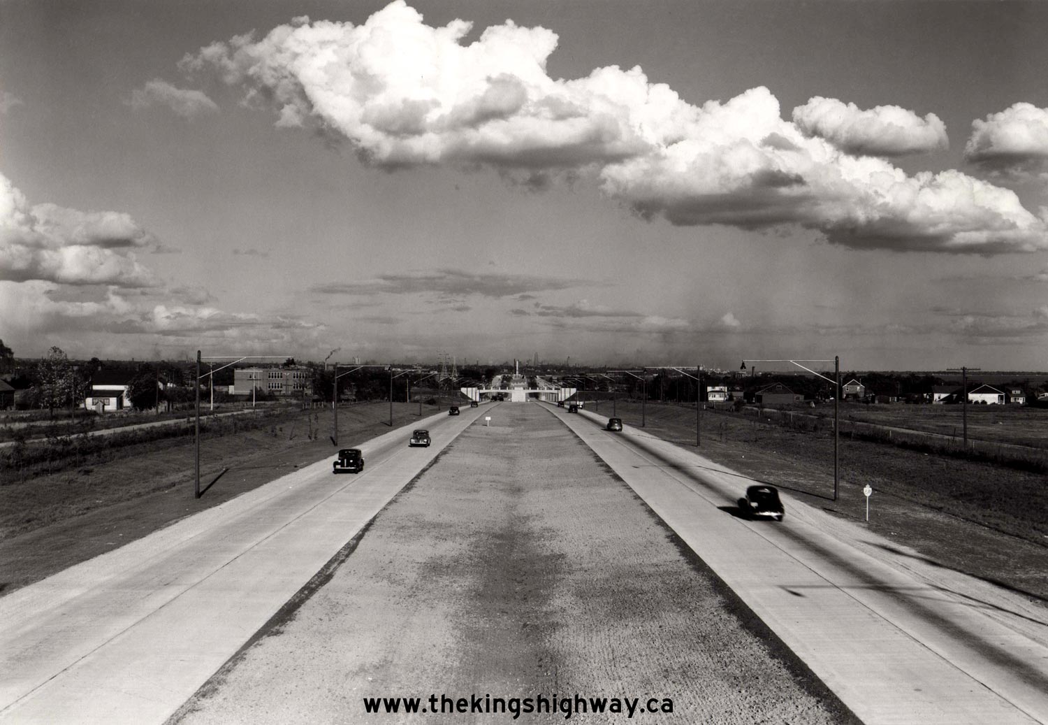
Above - Facing west along the Queen Elizabeth Way at the western entrance to Toronto from the Church Street (today's Royal York Road) Overpass in Etobicoke
Township. This early colour photo of the Queen Elizabeth Way was taken around 1949 and shows the four-lane Toronto Entrance Highway with its original concrete
surface. At the time this photo was taken, this section of the Queen Elizabeth Way had been open to traffic for just under a decade. Even through World War II was
still a recent memory at the time this photo was taken, the Post-War flight to the suburbs was already in motion. Note the newer industrial and housing developments
beginning to take form beside the highway. Toronto's population exploded in the years following World War II and along with it came a rapid increase in highway
traffic volumes. Highways which had been designed for the traffic volumes observed in the 1930s were quickly overwhelmed by the Post-War economic boom. By 1955, this
section of the Queen Elizabeth Way was carrying 34,000 vehicles on a typical day, with traffic volumes growing about 4 percent every year. By the late 1950s,
recurring traffic congestion on the western approach to Toronto had become such a problem that the DHO called a contract to widen the freeway from four to six lanes.
See an Enlarged Photo Here. Photo taken circa 1949. (Photo © Archives of Ontario - Series RG-65-35, Photo #I-0005498) 
Above - Circa 1949 view of the Queen Elizabeth Way at the western entrance to Toronto, facing east from the Church Street (today's Royal York Road) Overpass
in Etobicoke Township. In the far distance, one can see the hazy outline of Toronto's Downtown Skyline. At the time this photo was taken, the 34-storey Canadian Bank
of Commerce Building on King Street West was the tallest structure of the city's skyline. See an
Enlarged Photo Here. Photo taken circa 1949. (Photo © Archives of Ontario - Series RG-65-35, Photo #I-0005497) 
Above - Circa 1949 view of the Queen Elizabeth Way at the western entrance to Toronto, facing east from the Kipling Avenue Overpass in Etobicoke Township. In
September 1957, the DHO awarded a reconstruction contract to widen the Queen Elizabeth Way from four to six lanes between the Hwy 27 Cloverleaf and Mimico Creek
Bridge on the western approach to Toronto. This was done in response to surging traffic volumes along the highway which resulted from Ontario's Post-War economic
boom. See an Enlarged Photo Here. Photo taken circa 1949. (Photo © Archives of Ontario - Series RG-65-35, Photo #I-0005499) 
Left - Bituminous penetration paving operations underway by Miller Paving Ltd. on the Queen Elizabeth Way near Tea Creek north of Fort Erie. Under Contract
#1949-55, the northbound (Toronto-bound) lanes of the Queen Elizabeth Way were paved and were used by two-way traffic. The southbound (Fort Erie-bound) lanes were not
surfaced under this contract and were left with an unimproved roadway surface for several years thereafter. The Fort Erie-bound lanes remained closed to traffic for
many years following the Queen Elizabeth Way's arrival in Fort Erie in the early 1940s. See an
Enlarged Photo Here. Photo taken on September 15, 1949. (Photo courtesy of Ontario Ministry of Transportation - © King's Printer for Ontario, 1949) Right - Queen Elizabeth Way, 4 miles south of Niagara Falls shortly after bituminous penetration paving was completed on the Toronto-bound lanes, Contract #1949-55. While Fort Erie was linked to Toronto via a paved carriageway of the Queen Elizabeth Way by the end of 1949, it wasn't until 1956 that the opposing Fort Erie-bound lanes were paved and opened to traffic. See an Enlarged Photo Here. Photo taken on September 15, 1949. (Photo courtesy of Ontario Ministry of Transportation - © King's Printer for Ontario, 1949)
Continue on to Queen Elizabeth Way Historical Photos from 1950-1959
|
|---|
Links to Adjacent King's Highway Photograph Pages:
Back to King's Highway 427 Photos /
Queen Elizabeth Way History /
On to Secondary Highway 500 Photos
Ontario Highway History - Main Menu / Back to List of Highways Website contents, photos & text © 2002-2026, Cameron
Bevers (Webmaster) - All Rights Reserved / Contact Me
|
|---|