
| 
| |
|
|
This page contains historical photos of Ontario's Queen Elizabeth Way dating from 1960 to 1964. All photographs displayed on
this page were taken by the Ontario Ministry of Transportation, unless specifically noted otherwise. Historical photographs are arranged in approximate chronological
order. Click on any thumbnail to see a larger image!
Please note that all photographs displayed on this
website are protected by copyright. These photographs must not be reproduced, published,
electronically stored or copied, distributed, or posted onto other websites without
my written permission. If you want to use photos from this website, please
email me first for permission. Thank-you!
|
|---|
|
Page 4: Historical Queen Elizabeth Way Photographs (1960 to 1964)

Above - Circa 1960 postcard view of the Burlington Bay Skyway on the Queen Elizabeth Way between Burlington and Hamilton. Note the unusual median-mounted
fluorescent tube highway lighting system. When the Burlington Bay Skyway was twinned in the 1980s, the existing 1958 structure seen here was converted to carry four
lanes of Toronto-bound traffic only. All Niagara-bound traffic was diverted onto the newly-built south structure. Previously, the original structure carried two lanes
of Toronto-bound traffic and two lanes of Niagara-bound traffic. During rehabilitation of the existing skyway in the mid-1980s, the old highway median and
median-mounted luminaires were removed. New high-pressure sodium (HPS) highway luminaires were installed onto the outside barrier walls of both the original and new
Burlington Bay Skyway structures. (Photo courtesy of L.F. Charter) 
Above - Artist's concept drawing of the proposed Garden City (Homer) Skyway near St. Catharines (1960) (Photo courtesy of Ontario Ministry of Transportation - © King's Printer for Ontario, 1960) 

Left - Aerial view of the Queen Elizabeth Way & Hwy 27 Cloverleaf in Toronto, looking north along Hwy 27. See an
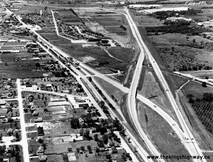
Enlarged Photo Here. Photo taken in June, 1960. (Photo © Archives of Ontario - RG-14-151-5-26, Photo #ES-13-894) Right - Aerial view of the Queen Elizabeth Way & Hwy 27 Cloverleaf in Toronto, looking northwest in 1960. This wonderful photo shows the entire area around the Queen Elizabeth Way & Hwy 27 (now Hwy 427) Interchange, including the open farm fields just beyond the cloverleaf. This is where the Sherway Gardens Shopping Centre is located today. A cloverleaf interchange had existed at the intersection of these two highways since 1940. When Hwy 27 was reconstructed and widened to four lanes in the mid-1950s, the ramps of the cloverleaf were completely realigned. The inner loop ramps were enlarged to smooth traffic flow, particularly for the heavily-traveled Toronto-bound Queen Elizabeth Way to northbound Hwy 27 inner loop ramp in the foreground. Note the size of this loop ramp compared to those found in the other three interchange quadrants. The increased size of this loop ramp provided a greater distance for traffic to merge on and off the loop ramp from the mainline freeway. Although the retrofits to the interchange made between 1955 and 1958 were a vast improvement over the original 1940 cloverleaf, the interchange still experienced significant congestion at peak times. The cloverleaf interchange at Hwy 27 was completely replaced by the current four-level interchange in the late 1960s. See an Enlarged Photo Here. Photo taken in June, 1960. (Photo © Archives of Ontario - RG-14-151-5-26, Photo #ES-13-892) 
 Left - Aerial view of the Queen Elizabeth Way & Old Hwy 25 Cloverleaf (Guelph Line) in Burlington, facing west. See an Enlarged Photo Here. Photo taken in June, 1960. (Photo © Archives of Ontario - RG-14-151-5-26, Box B1106, Photo #ES-13-968) Right - Aerial view of the Freeman Diversion on the Queen Elizabeth Way in Burlington, facing west towards the future Hwy 403 Interchange in 1960. This photo shows the completed Freeman Diversion on the Queen Elizabeth Way in Burlington, which was completed in 1958. The Freeman Diversion bypassed the community of Freeman and provided improved access to the Burlington Bay Skyway from the Toronto leg of the Queen Elizabeth Way. The construction of the Freeman Diversion also permitted connections to the proposed route of Hwy 403 between Hamilton and Burlington at the Freeman Interchange. The three bridges at the proposed Freeman Interchange were built in 1957, well in advance of the remainder of the Burlington section of Hwy 403. The three Hwy 403 Interchange structures can be seen standing in a field in the background of this photo. The county road passing under the Freeman Diversion in the background is today's Brant Street. The bypassed portion of the original Queen Elizabeth Way through the community of Freeman follows today's Plains Road, seen in this photo at upper-left. See an Enlarged Photo Here. Photo taken in June, 1960. (Photo © Archives of Ontario - RG-14-151-5-26, Box B1106, Photo #ES-13-972) 
Left - Dorchester Road Traffic Circle on the Queen Elizabeth Way (Rainbow Bridge Approach) in Niagara Falls. This early traffic circle was constructed along
the Rainbow Bridge Approach (today's Hwy 420) in 1941. The "circle" itself was actually oval-shaped, and connected the dual highway approaching the Rainbow Bridge
with Dorchester Road. The Hydro Canal leading to Queenston crossed through the middle of the traffic circle. Please click here to see a
1947 Aerial Photo of the Dorchester Road Traffic Circle. Two new structures were built along the
"legs" of the oval to carry the highway perpendicularly across the Hydro Canal. The Dorchester Road Traffic Circle provided a very economical method of joining the
two roads together, and worked quite well during the early days of the Queen Elizabeth Way. However, growing traffic volumes in the Niagara Falls area prompted the
Department of Highways of Ontario (DHO) to replace the old 1941 traffic circle with a modern grade-separated interchange in the early 1970s. The westbound Queen
Elizabeth Way structure seen here was removed in 1971 when a new interchange was built at Dorchester Road and Hwy 420. See an
Enlarged Photo Here. Photo taken on April 14, 1961. (Photo courtesy of Ontario Ministry of Transportation - © King's Printer for Ontario, 2013) Right - Hydro Canal Bridge on the Dorchester Road Traffic Circle, facing east towards the Rainbow Bridge in Niagara Falls. Photo taken on April 14, 1961. (Photo courtesy of Ontario Ministry of Transportation - © King's Printer for Ontario, 2013) 

Left - Approaching the exit to Dorchester Road North on the Queen Elizabeth Way in Niagara Falls. Note the oversized checkerboard sign at the far side of the
structure, to warn drivers of the sharp curve ahead. The elongated oval shape of the Dorchester Road Traffic Circle and tangential entries and exits on the Queen
Elizabeth Way encouraged motorists to travel through this rotary intersection at much higher speeds than what would be possible in a modern roundabout design.
Excessive circle diameter and tangential entries and exits were common geometric design problems which plagued many older rotary intersections in North America. This
led to a general rejection of the overall concept of rotary intersections by North American road authorities for almost 40 years, until more compact modern
roundabouts with curved entries and exits began to appear in the 1990s. The first modern roundabout built on an Ontario provincial highway was completed on Hwy 33 in
Picton in 2009. See an Enlarged Photo Here. Photo taken on April 14, 1961. (Photo courtesy of Ontario Ministry of Transportation - © King's Printer for Ontario, 2013) Right - Hydro Canal Bridge on the Queen Elizabeth Way at the Dorchester Road Traffic Circle in Niagara Falls. Photo taken on April 14, 1961. (Photo courtesy of Ontario Ministry of Transportation - © King's Printer for Ontario, 2013) 
Above - Lake Street Interchange and Overpass on the Queen Elizabeth Way in St. Catharines. See an
Enlarged Photo Here. Photo taken on April 19, 1961. (Photo courtesy of Ontario Ministry of Transportation - © King's Printer for Ontario, 2011) 

Left - Burlington Street Overpass on the Queen Elizabeth Way in Hamilton. Photo taken on May 8, 1961. (Photo courtesy of Ontario Ministry of Transportation - © King's Printer for Ontario, 2014) Right - Burlington Street Interchange on the Queen Elizabeth Way in Hamilton, facing north across the QEW. See an Enlarged Photo Here. Photo taken on May 8, 1961. (Photo courtesy of Ontario Ministry of Transportation - © King's Printer for Ontario, 2014) 
Above - New Shook's Hill Interchange on the Queen Elizabeth Way at Southdown Road & Erin Mills Parkway between Port Credit and Oakville in 1961. This
British Motorway-style "rotary" interchange at Southdown Road & Erin Mills Parkway was built on the Queen Elizabeth Way west of Port Credit in 1958-1959. This
unique interchange was the only one of its kind ever built in Ontario. Initially, the rotary interchange worked quite well under the comparatively low traffic volumes
of the 1950s. However, the short weaving sections adjacent to the off-ramps within the rotary began to exhibit operational deficiencies as traffic volumes grew in the
1960s and early 1970s. In an effort to improve safety and increase traffic capacity at the interchange, the Ministry of Transportation and Communications took action
by modifying the interchange in 1974. The two off-ramps from the Queen Elizabeth Way were realigned and removed from the rotary. As a result of the reconfiguration,
traffic exiting from the freeway bypassed the rotary entirely, and joined directly to Southdown Road and Erin Mills Parkway at signalized intersections. Despite the
retrofits in the 1970s, the prominent rotary configuration seen in this photo existed right up until 1999-2000, when this interchange was completely rebuilt. See an
Enlarged Photo Here. Photo taken in June, 1961. (Photo © Archives of Ontario - Series RG-14-151-5-26, Photo #ES15-002) 
Above - Construction of the Garden City (Homer) Skyway near St. Catharines (1961) (Photo courtesy of Ontario Ministry of Transportation - © King's Printer for Ontario, 1961) 

Left - Facing north across the Cawthra Road Overpass on the Queen Elizabeth Way east of the
Hwy 10 Interchange in Port Credit. See an Enlarged Photo Here. Photo taken on April 18, 1962. (Photo courtesy of Ontario Ministry of Transportation - © King's Printer for Ontario, 2014) Right - Queen Elizabeth Way at the Cawthra Road Interchange between Toronto and Port Credit in 1962, facing west towards the Hwy 10 Interchange. Up until the mid-1950s, Cawthra Road crossed the Queen Elizabeth Way at-grade. As part of its long-term strategy to convert the Queen Elizabeth Way into a controlled-access facility, the DHO called a contract to construct a grade separation at Cawthra Road in 1955. Small ramps were built along the service roads, which provided access between Cawthra Road and the Queen Elizabeth Way. Unfortunately, the ramps at the original Cawthra Road Interchange were extremely short with very limited traffic capacity. Initially, the short ramps at the Cawthra Road Interchange did not pose much of a problem, since traffic demand in the 1950s was fairly light. However, the phenomenal suburban growth which took place in Mississauga during the 1970s doomed the original interchange - it was quickly overrun by the rapidly-growing traffic demands along the Queen Elizabeth Way corridor. By the mid-1970s, only 20 years after it was built, the interchange was already functionally obsolete, and planning got underway to completely rebuild the interchange. The original 1955 Cawthra Road Interchange survived until 1979, when it was replaced by a larger overpass and a high-capacity partial cloverleaf interchange. See an Enlarged Photo Here. Photo taken on April 18, 1962. (Photo courtesy of Ontario Ministry of Transportation - © King's Printer for Ontario, 2014) 

Left - Dillon's (Cooksville) Creek Bridge on the Queen Elizabeth Way east of the Hwy 10 Interchange in Port Credit. See an
Enlarged Photo Here. Photo taken on April 18, 1962. (Photo courtesy of Ontario Ministry of Transportation - © King's Printer for Ontario, 2013) Right - Etobicoke Creek Bridge on the Queen Elizabeth Way between Toronto and Port Credit in 1962. This graceful open-spandrel concrete arch structure was built in 1932 as part of the first phase of the new Middle Road superhighway to Port Credit. The Middle Road was eventually renamed the Queen Elizabeth Way in 1939. The original 1932 Etobicoke Creek structure still exists today, although it is now flanked on both sides by newer 1960s-era concrete girder structures, which carry the ramps to Evans Avenue. See an Enlarged Photo Here. Photo taken on April 18, 1962. (Photo courtesy of Ontario Ministry of Transportation - © King's Printer for Ontario, 2013) 
Above - Traffic signals on the Queen Elizabeth Way at Bunting Road in St. Catharines near the Garden City (Homer) Skyway construction site. Traffic signals
were once a very common sight along the Queen Elizabeth Way. Although it was a four-lane divided highway, most intersections along the route met the divided highway
at-grade. As traffic volumes along the Queen Elizabeth Way increased, it became necessary to install traffic signals at some intersections. The first traffic signals
appeared along the Middle Road (Queen Elizabeth Way) in 1937. By 1948, there were no fewer than five signalized intersections along the divided highway between Port
Credit (Mississauga) and Burlington. Many more traffic signals were installed along the Queen Elizabeth Way between Hamilton and St. Catharines during the 1950s and
1960s. These traffic signal installations were eventually removed from the Queen Elizabeth Way by the 1970s, once all of the at-grade intersections along the highway
had either been closed off or grade-separated. See an Enlarged Photo Here. Photo taken in June,
1962. (Photo from Cameron Bevers' historical photograph collection - Original photographer unknown) 
Above - A pair of construction cranes hoist a pre-stressed concrete girder into place at the new Port Credit Cloverleaf at the Queen Elizabeth Way & Hwy 10
in 1962. This new interchange was built to replace the old Port Credit Cloverleaf, which had been in service since 1937. The new interchange was needed to address
operational and safety problems with the old interchange and to accommodate the widening of the Queen Elizabeth Way from four to six lanes. (Photo courtesy of Ontario Ministry of Transportation - © King's Printer for Ontario, 1962) 

Left - A trio of construction workers assemble structural steel for the new Garden City (Homer) Skyway near St. Catharines (1962) (Photo courtesy of Ontario Ministry of Transportation - © King's Printer for Ontario, 1962) Right - Construction of the Garden City (Homer) Skyway Toll Plaza east of St. Catharines (1963) (Photo courtesy of Ontario Ministry of Transportation - © King's Printer for Ontario, 1963) 

Left - Aerial view of the Henley Bridge and the Martindale Road Interchange on the Queen Elizabeth Way approaching St. Catharines in 1964. In this photo, the
Martindale Road Interchange still had its original 1939 ramp configuration. When Hwy 406 was constructed a short distance to the west in the early 1980s, some ramps
at the Martindale Road Interchange had to be relocated or closed altogether. See an
Enlarged Photo Here. Photo taken on May 4, 1964. (Photo courtesy of Ontario Ministry of Transportation - © King's Printer for Ontario, 2019) Right - Aerial view of the Queen Elizabeth Way at Ontario Street in St. Catharines in 1964. At the time this photo was taken, Ontario Street met the Queen Elizabeth Way at an at-grade signalized intersection. In 1966, a contract was tendered to build a grade separation and interchange at Ontario Street. This project removed the last signalized intersection along the Queen Elizabeth Way through St. Catharines. See an Enlarged Photo Here. Photo taken on May 4, 1964. (Photo courtesy of Ontario Ministry of Transportation - © King's Printer for Ontario, 2019) 

Left - Aerial view of the Lake Street Interchange on the Queen Elizabeth Way in St. Catharines in 1964. This photo shows the Lake Street Interchange, as it was
originally constructed in 1955. Shortly after this photo was taken, the interchange was modified to accommodate the construction of continuous North & South
Service Roads between Lake Street and Geneva Street. This gap in the service road system was due to the N.S. & T. Railway Subway, which existed between Lake
Street and Geneva Street. When this railway subway was first built in 1939, it only had enough space for the lanes of the Queen Elizabeth Way itself, as the service
road concept was not envisioned at the time of the subway's construction. Note that the North & South Service Roads resume immediately east of the N.S. & T.
Railway Subway, with slip ramps connecting to the freeway. In 1965, a contract was tendered to demolish the disused N.S. & T. Railway Subway and extend the
service roads so that they connected directly to Lake Street. See an Enlarged Photo Here. Photo
taken on May 4, 1964. (Photo courtesy of Ontario Ministry of Transportation - © King's Printer for Ontario, 2019) Right - Aerial view of the Niagara Street Interchange on the Queen Elizabeth Way in St. Catharines in 1964. At the time this photo was taken, the old 1939 interchange was in the process of being reconstructed. The old overpass had already been removed, and traffic was diverted onto a pair of temporary Bailey Bridges so that the replacement Niagara Street Overpass could be constructed on the existing street alignment. Also note the Geneva Street Underpass located a short distance to the west, which was completed in 1956. See an Enlarged Photo Here. Photo taken on May 4, 1964. (Photo courtesy of Ontario Ministry of Transportation - © King's Printer for Ontario, 2019) 

Left - Aerial view of the Queen Elizabeth Way at Welland Avenue in St. Catharines in 1964. The recently-completed Welland Avenue Underpass can be seen near the
centre of this photo. Like many other streets in St. Catharines, Welland Avenue initially crossed the Queen Elizabeth Way at an at-grade signalized intersection. As
the northern part of St. Catharines continued to grow, traffic congestion at these signalized intersections became a serious problem. An underpass was constructed for
Welland Avenue in 1961, as part of a long-term highway improvement program to convert the Queen Elizabeth Way through St. Catharines from a conventional divided
highway to a full controlled-access freeway - a process which took place gradually over a period of almost 30 years. See an
Enlarged Photo Here. Photo taken on May 4, 1964. (Photo courtesy of Ontario Ministry of Transportation - © King's Printer for Ontario, 2019) Right - Aerial view of the Queen Elizabeth Way at the western end of the new Garden City (Homer) Skyway in St. Catharines in 1964. This interesting photo still shows the various temporary diversion roads required for traffic staging during this massive 4-year construction project. During construction, all traffic on the Queen Elizabeth Way was temporarily diverted to the north, as seen in the 1962 Photo above. Construction began on the Homer Skyway in 1960. The renamed "Garden City Skyway" opened to traffic on October 18, 1963, about six months before this photo was taken. See an Enlarged Photo Here. Photo taken on May 4, 1964. (Photo courtesy of Ontario Ministry of Transportation - © King's Printer for Ontario, 2019) 
Above - Aerial view of the old Homer Cloverleaf (Cushman Road Interchange) at Hwy 8 beside the Garden City Skyway in 1964. In this photo, the bypassed Cushman
Road Interchange still had its original 1939 ramp configuration. Once the Queen Elizabeth Way was diverted onto the new Garden City Skyway, the cloverleaf ramps at
Cushman Road were removed. The bypassed alignment of the Queen Elizabeth Way was also extensively modified. The old Toronto-bound lanes were converted to accommodate
two-way traffic, while the old Niagara-bound lanes of the highway were abandoned and grassed over. See an
Enlarged Photo Here. Photo taken on May 4, 1964. (Photo courtesy of Ontario Ministry of Transportation - © King's Printer for Ontario, 2019) 

Left - Queen Elizabeth Way approaching Glendale Avenue and the Garden City Skyway Toll Plaza near St. Catharines in 1964. The Glendale Avenue Interchange was
essentially a double-interchange. It provided full access between adjacent Hwy 8 and the Queen Elizabeth Way. When the Garden City Skyway first opened to traffic in
1963, it was a toll bridge. The Garden City Skyway Toll Plaza seen in the background was removed after tolls were lifted from the skyway in 1973. Fluorescent tube
highway luminaires were installed along this section of the Queen Elizabeth Way as part of the Garden City Skyway and Hwy 405 construction. This was one of only two
sections along the Queen Elizabeth Way where a fluorescent tube highway illumination system was used. The other section where fluorescent tube highway lighting was
used was on the approaches to the Burlington Bay Skyway. The fluorescent tube lighting system at the Garden City Skyway was eventually switched over to a
high-pressure sodium (HPS) illumination system in the mid-1980s. See an Enlarged Photo Here.
Photo taken in May, 1964. (Photo courtesy of Ontario Ministry of Transportation - © King's Printer for Ontario, 2014) Right - Facing south across the Glendale Avenue Overpass on the Queen Elizabeth Way near St. Catharines in 1964. Note how rural the area around the Glendale Avenue Interchange was at that time, compared to what it looks like today. Substantial development has occurred around this interchange in recent years. Note the Hwy 8 and "To Hwy 8A" route markers mounted on the median island, facing traffic exiting from the Toronto-bound Queen Elizabeth Way. Until Hwy 405 was completed and opened to traffic in September, 1963, Hwy 8A formed the only provincial highway link to the Queenston International Bridge. See an Enlarged Photo Here. Photo taken in May, 1964. (Photo courtesy of Ontario Ministry of Transportation - © King's Printer for Ontario, 2014) 

Left - Facing east along Hwy 8 at the Glendale Avenue and Queen Elizabeth Way Interchange near St. Catharines in 1964. This rather strange interchange was
completed in 1962 and remained in service until the 1990s. When York Road (Former Hwy 8) was relocated onto a new alignment in the late 1990s, it essentially made
this interchange redundant and was subsequently closed. See an Enlarged Photo Here. Photo taken
in May, 1964. (Photo courtesy of Ontario Ministry of Transportation - © King's Printer for Ontario, 2014) Right - Facing south across the Hwy 8 Underpass at the Queen Elizabeth Way and Glendale Avenue Interchange near St. Catharines in 1964. Now demolished, this interchange used to exist immediately north of the Queen Elizabeth Way. It provided access to Hwy 8 from Glendale Avenue and adjacent Queen Elizabeth Way. The interchange became redundant in the 1990s when Glendale Avenue was extended north to meet a realigned York Road (Former Hwy 8). The ramps and abandoned underpass stood for several years, before they were demolished. See an Enlarged Photo Here. Photo taken in May, 1964. (Photo courtesy of Ontario Ministry of Transportation - © King's Printer for Ontario, 2014) 

Left - Fort Erie-bound Lyons Creek Bridge on the Queen Elizabeth Way south of Niagara Falls. Photo taken in May, 1964. (Photo courtesy of Ontario Ministry of Transportation - © King's Printer for Ontario, 2011) Right - Western side of the Lyons Creek Bridge on the Queen Elizabeth Way between Niagara Falls and Fort Erie. Photo taken in May, 1964. (Photo courtesy of Ontario Ministry of Transportation - © King's Printer for Ontario, 2011) 

Left - Bridge coring operation underway at the Lyons Creek Bridge on the Queen Elizabeth Way south of Niagara Falls. Photo taken in May, 1964. (Photo courtesy of Ontario Ministry of Transportation - © King's Printer for Ontario, 2011) Right - Resurfaced Queen Elizabeth Way at Lyons Creek Bridge between Niagara Falls and Fort Erie. Photo taken in May, 1964. (Photo courtesy of Ontario Ministry of Transportation - © King's Printer for Ontario, 2011) 

Left - Bridge coring operation underway at the Tee Creek Bridge on the Queen Elizabeth Way south of Niagara Falls. Photo taken in May, 1964. (Photo courtesy of Ontario Ministry of Transportation - © King's Printer for Ontario, 2011) Right - Tee Creek Bridge on the Queen Elizabeth Way south of Niagara Falls. Photo taken in May, 1964. (Photo courtesy of Ontario Ministry of Transportation - © King's Printer for Ontario, 2011) 
Above - Plan showing the proposed improvements to the Hwy 25 (Guelph Line) Interchange on the Queen Elizabeth Way in Burlington. The north half of the
cloverleaf interchange was removed and replaced with a modified diamond interchange ramp configuration, along with an extension of the North Service Road to
Plains Road. Plan dated May, 1964. (Photo courtesy of Ontario Ministry of Transportation - © King's Printer for Ontario, 1964) 
Above - Construction crew pouring concrete pavement at the new Niagara Street Interchange on the Queen Elizabeth Way in St. Catharines (1964) (Photo courtesy of Ontario Ministry of Transportation - © King's Printer for Ontario, 1964) 

Left - Freeman Interchange at the Queen Elizabeth Way and Hwy 403 in Burlington. See an
Enlarged Photo Here. Photo taken in June, 1964. (Photo courtesy of Ontario Ministry of Transportation - © King's Printer for Ontario, 2013) Right - Grade separation at the Freeman Interchange in Burlington in 1964. Three nearly identical structures were built at this interchange in 1957 to carry the connecting ramps between Hwy 403 and the Queen Elizabeth Way. Although the interchange was not fully opened to traffic until December, 1963, the Freeman Interchange was one of the earliest high-speed freeway-to-freeway interchanges designed in Ontario. The Freeman Interchange marked a radical departure from the traditional cloverleaf and other lower-speed interchange designs that typified most freeway-to-freeway junctions built in Ontario prior to 1957. See an Enlarged Photo Here. Photo taken in June, 1964. (Photo courtesy of Ontario Ministry of Transportation - © King's Printer for Ontario, 2013)
Continue on to Queen Elizabeth Way Historical Photos from 1965-1969
|
|---|
Links to Adjacent King's Highway Photograph Pages:
Back to King's Highway 427 Photos /
Queen Elizabeth Way History /
On to Secondary Highway 500 Photos
Ontario Highway History - Main Menu / Back to List of Highways Website contents, photos & text © 2002-2026, Cameron
Bevers (Webmaster) - All Rights Reserved / Contact Me
|
|---|