
| 
| |
|
|
This page contains historical photos of Ontario's Queen Elizabeth Way dating from 1970 to 1974. All photographs displayed on
this page were taken by the Ontario Ministry of Transportation, unless specifically noted otherwise. Historical photographs are arranged in approximate chronological
order. Click on any thumbnail to see a larger image!
Please note that all photographs displayed on this
website are protected by copyright. These photographs must not be reproduced, published,
electronically stored or copied, distributed, or posted onto other websites without
my written permission. If you want to use photos from this website, please
email me first for permission. Thank-you!
|
|---|
|
Page 6: Historical Queen Elizabeth Way Photographs (1970 to 1974)

Above - Aerial view of the Stoney Creek Traffic Circle on the Queen Elizabeth Way at Hwy 20 (April 7, 1970) (Photo © Archives of Ontario - Series RG-14-151-21-10, Photo #12651A) The Stoney Creek Traffic Circle was once one of the most prominent features on the Queen Elizabeth Way. The gigantic traffic circle was completed in 1938, and provided access between the Queen Elizabeth Way and Hwy 20 (Centennial Parkway). The Stoney Creek Traffic Circle was removed in the mid-1970s, and replaced by a freeway grade separation and interchange. The railway line running across the diameter of the circle was removed at the same time. See an Enlarged Photo here. 

Left - New Glover Road Overpass and South Service Road on the Queen Elizabeth Way in Stoney Creek. See an
Enlarged Photo here. Photo taken in May, 1970. (Photo courtesy of Ontario Ministry of Transportation - © King's Printer for Ontario, 2014) Right - Facing north across the Glover Road Overpass on the Queen Elizabeth Way. See an Enlarged Photo here. Photo taken in May, 1970. (Photo courtesy of Ontario Ministry of Transportation - © King's Printer for Ontario, 2014) 

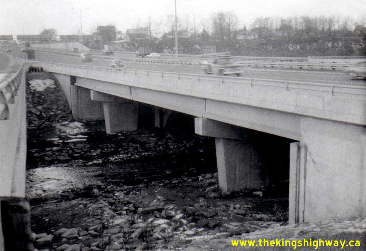
Left - Approaching Etobicoke Creek and the Evans Avenue Interchange on the Queen Elizabeth Way in Toronto. See an
Enlarged Photo here. Photo taken on November 25, 1971. (Photo courtesy of Ontario Ministry of Transportation - © King's Printer for Ontario, 2014) Right - Facing west towards the Etobicoke Creek Bridge on the Queen Elizabeth Way. See an Enlarged Photo here. Photo taken on November 25, 1971. (Photo courtesy of Ontario Ministry of Transportation - © King's Printer for Ontario, 2014) 

Left - Queen Elizabeth Way at the new Seventh Street Interchange near St. Catharines in 1972, facing west. This new interchange was built in 1970 immediately
west of the present-day site of the Hwy 406 Interchange. This was one of several interchanges built between Stoney Creek and St. Catharines between 1965 and 1975, in
an effort to convert the Queen Elizabeth Way into a fully controlled access freeway. See an
Enlarged Photo here. Photo taken on April 21, 1972. (Photo courtesy of Ontario Ministry of Transportation - © King's Printer for Ontario, 2014) Right - Seventh Street Overpass on the Queen Elizabeth Way near St. Catharines, facing north. See an Enlarged Photo here. Photo taken on April 21, 1972. (Photo courtesy of Ontario Ministry of Transportation - © King's Printer for Ontario, 2014) 

Left - Approaching the Tufford Road Overpass on the Queen Elizabeth Way near Grimsby. See an
Enlarged Photo here. Photo taken on April 21, 1972. (Photo courtesy of Ontario Ministry of Transportation - © King's Printer for Ontario, 2014) Right - Facing north across the Tufford Road Overpass on the Queen Elizabeth Way. Until the late 1960s, an old pedestrian tunnel used to exist at Tufford Road, which passed underneath the Queen Elizabeth Way. In 1969, a contract was awarded to build a new grade separation for Tufford Road across the Queen Elizabeth Way. As part of the construction contract, the old pedestrian tunnel below the Queen Elizabeth Way was sealed off by bricking up the entrances to the tunnel at each end and removing the staircases leading to the tunnel. The remainder of the pedestrian tunnel was abandoned and lies buried below the current highway. See an Enlarged Photo here. Photo taken on April 21, 1972. (Photo courtesy of Ontario Ministry of Transportation - © King's Printer for Ontario, 2014) 
Above - Aerial view of the Queen Elizabeth Way Monument and Canadian National Railway Overpass in Toronto (August 21, 1972) (Photo courtesy of Archives of Ontario - Series RG-14-151-7-16, Photo #15135B) This photo shows the Canadian National (CN) Railway Overpass and the Queen Elizabeth Way Monument just prior to the reconstruction and widening of the Queen Elizabeth Way in the early 1970s. The old CN Railway flyover was originally constructed in 1939, but it was demolished during the reconstruction project. Fortunately, the beautiful Queen Elizabeth Way Monument in the highway median was saved and was relocated to a nearby park in 1974. See an Enlarged Photo here. 

Left - Aerial view of the Queen Elizabeth Way at the Guelph Line Interchange in 1973. When the interchange at Guelph Line (Formerly Hwy 25) was first built in
1957, it was a full eight-ramp cloverleaf interchange as seen in this Historic 1960 Photo. However,
the proximity of the Hwy 25 Cloverleaf to the adjacent exit to Plains Road proved to be a problem, since the exit to Plains Road was a left-hand exit. Traffic
entering the Niagara-bound Queen Elizabeth Way from Guelph Line heading for Plains Road had a very limited distance to merge across the through lanes in order to exit
the freeway. The Toronto-bound direction was even worse, where traffic entering the Queen Elizabeth Way was expected to do an almost impossible merge in order to
continue east towards Toronto. In 1964, a contract was awarded to retrofit the interchange, by removing the north half of the cloverleaf and extending Plains Road
easterly through to Hwy 25 (Guelph Line). Following reconstruction, Toronto-bound traffic wishing to exit the Queen Elizabeth Way had to continue through to the loop
ramp of the cloverleaf in order to access Guelph Line. The interchange configuration seen here remained more or less unmodified up until 2002, when the Guelph Line
Interchange was fully rebuilt at a more conventional "Parclo A-4" interchange. See an
Enlarged Photo here. Photo taken in 1973. (Photo courtesy of Ontario Ministry of Transportation - © King's Printer for Ontario, 2014) Right - Aerial view of the Queen Elizabeth Way between Guelph Line and Brant Street in 1973. The now-removed partial interchange at Plains Road can be seen at right. Note the "park-and-ride" GO Transit bus commuter parking lot on Plains Road, which was first inaugurated in 1970. This was the first facility of its kind constructed along the Queen Elizabeth Way corridor between Burlington and Toronto. Note the absence of an interchange at Brant Street, which wasn't built until 1989-1990. See an Enlarged Photo here. Photo taken in 1973. (Photo courtesy of Ontario Ministry of Transportation - © King's Printer for Ontario, 2014) 

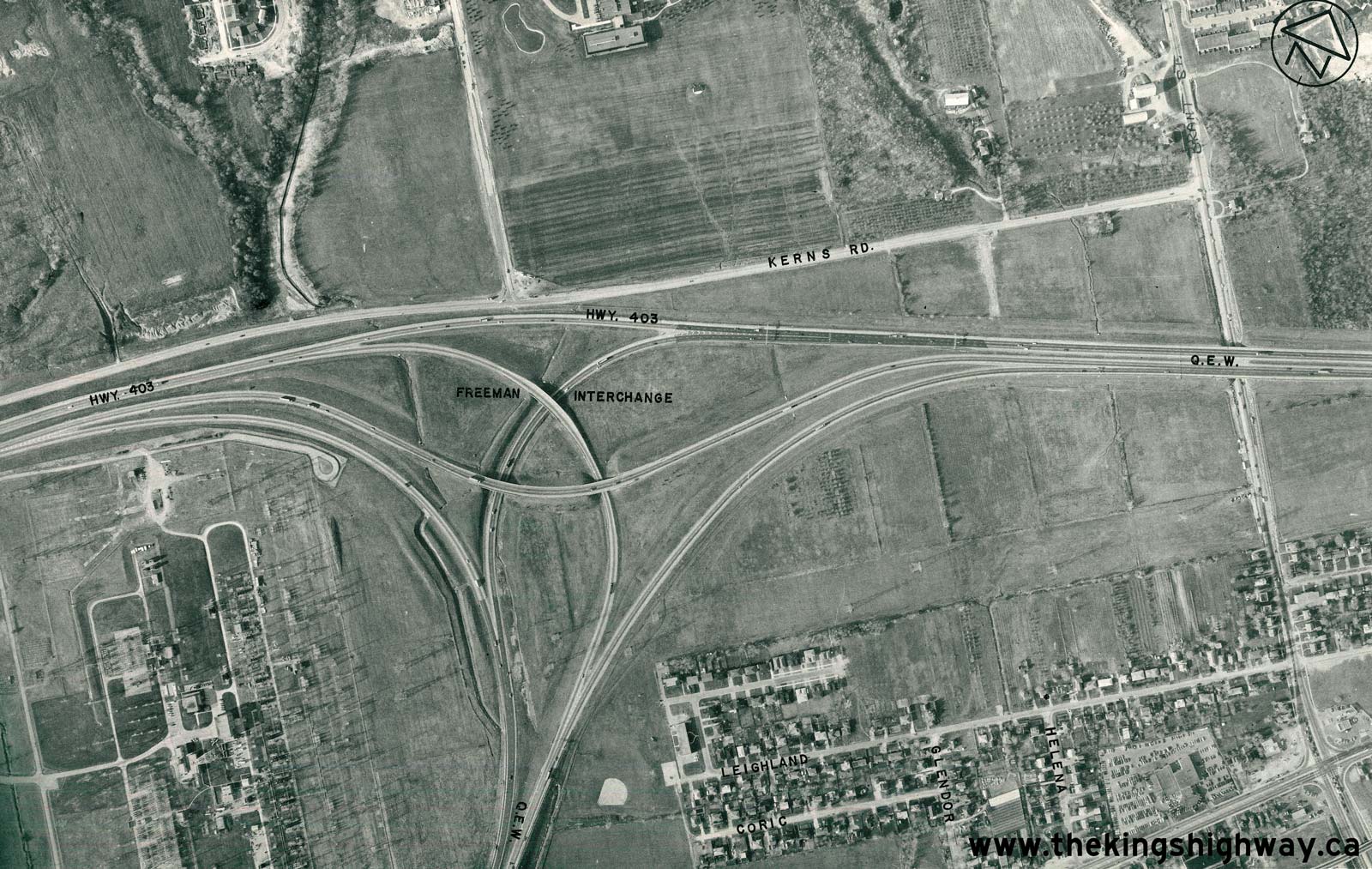
Left - Aerial view of the Queen Elizabeth Way at the Freeman Interchange in 1974. This photo shows the fully-directional interchange constructed at the
junction of Hwy 403 and the Queen Elizabeth Way. The Freeman Interchange was one of the earliest high-speed freeway-to-freeway interchanges designed in Ontario. The
interchange was partially opened to traffic with the completion of the Freeman Diversion on the Queen Elizabeth Way in 1958. The interchange was put into full
operation when Hwy 403 was opened to traffic between Burlington and Hamilton in December, 1963. The original Freeman Interchange seen here was replaced with a new
interchange during an ambitious multi-year construction project which began in 1991. See an
Enlarged Photo here. Photo taken in 1974. (Photo courtesy of Ontario Ministry of Transportation - © King's Printer for Ontario, 2014) Right - Aerial view of the Queen Elizabeth Way at the Old Burlington Interchange at Plains Road in 1974. During construction of the Freeman Diversion and Burlington Skyway Approach in the late 1950s, the Old Burlington Interchange was partially bypassed. This small "trumpet" interchange was originally built in 1936 at the junction of the Middle Road Highway and the New Niagara Falls Highway. In 1958, two of the Old Burlington Interchange ramps were closed off to traffic. The on-ramp from eastbound Plains Road to the Niagara-bound Queen Elizabeth Way and the old Toronto-bound loop ramp to westbound Plains Road were closed off to traffic permanently. The remainder of the Old Burlington Interchange was removed in 1984, when a new interchange was built at Plains Road. At the time this photo was taken, this area was still fairly rural. Today, the area around the Plains Road Interchange is home to the busy Mapleview Shopping Centre and the Burlington IKEA store. See an Enlarged Photo here. Photo taken in 1974. (Photo courtesy of Ontario Ministry of Transportation - © King's Printer for Ontario, 2014) 

Left - Aerial view of the Queen Elizabeth Way at the Hwy 2 Cloverleaf in 1974. In preparation
for the Burlington Skyway twinning, this interchange was extensively reconfigured in 1982-1983. A short collector lane system and a partial basketweave were built on
the Queen Elizabeth Way approaching the Hwy 2 Interchange in order to provide direct access to the new service road (today's Eastport Drive). To the right of the
Hwy 2 Interchange, traces of an old concrete highway can be seen leading south towards Lakeshore Road. This is a portion of the original 1930s-era Queen Elizabeth Way,
which temporarily tied into Hwy 20 (Lakeshore Road) at Burlington Beach before the Burlington Skyway was built. The road was abandoned in 1958 when the Burlington
Skyway was completed. This Historic 1940 Photo shows the old section of the highway while it was
being used by traffic in the early days of the Queen Elizabeth Way. See an
Enlarged Photo here. Photo taken in 1974. (Photo courtesy of Ontario Ministry of Transportation - © King's Printer for Ontario, 2014) Right - Aerial view of the Queen Elizabeth Way at the Burlington Skyway in 1974. The original Burlington Skyway carried traffic in both directions until a twin skyway was completed in the 1980s. Note the Canadian National (CN) Railway line running across the Burlington Canal Lift Bridge. In preparation for the Burlington Skyway twinning in the 1980s, a new service road network was constructed below the skyway in 1982. In conjunction with this work, the roadway across the lift bridge was widened from two to four lanes, by removing the abandoned CN Railway line from the structure. See an Enlarged Photo here. Photo taken in 1974. (Photo courtesy of Ontario Ministry of Transportation - © King's Printer for Ontario, 2014) 

Left - Aerial view of the Queen Elizabeth Way at the southern approach to the Burlington Skyway in 1974. As originally designed in the 1950s, the Burlington
Skyway accommodated four lanes of traffic (two lanes per direction). As traffic volumes grew in the 1960s and 1970s, it became clear that additional lanes were
required. Construction began on a second bridge beside the original skyway in 1983. Extensive changes were made to the road network around the Burlington Skyway,
including the construction of a new service road along the entire south side of the beach strip in 1982 (today's Eastport Drive). See an
Enlarged Photo here. Photo taken in 1974. (Photo courtesy of Ontario Ministry of Transportation - © King's Printer for Ontario, 2014) Right - Aerial view of the Queen Elizabeth Way at Hamilton Beach in 1974. Of particular note here is the abandoned Burlington Skyway Toll Plaza, which can be seen at left. Toll collection on the Burlington Skyway was discontinued in 1973, 15 years after the toll bridge was first opened to traffic. A demolition contract was awarded by the Ministry of Transportation and Communications in late 1973 to remove the toll plaza at this location as well as the old toll plaza at the Garden City Skyway in St. Catharines. This photo shows the abandoned Burlington Skyway Toll Plaza shortly before it was demolished. See an Enlarged Photo here. Photo taken in 1974. (Photo courtesy of Ontario Ministry of Transportation - © King's Printer for Ontario, 2014) 

Left - Aerial view of the Queen Elizabeth Way at the Burlington Street Interchange in 1974.
Although the Burlington Street Interchange changed very little during its near 50-year existence, the adjacent interchange at Woodward Avenue (labelled incorrectly on
the original photo) underwent major reconstruction during the 1980s, during which time several of the interchange ramps were removed. See an
Enlarged Photo here. Photo taken in 1974. (Photo courtesy of Ontario Ministry of Transportation - © King's Printer for Ontario, 2014) Right - Aerial view of the Queen Elizabeth Way at Stoney Creek in 1974. The infamous Stoney Creek Traffic Circle at Hwy 20 provided the main access point from the Queen Elizabeth Way into Stoney Creek. This massive rotary intersection was originally constructed in 1938. It was removed during a highway reconstruction project which began almost immediately after this photo was taken. By the end of 1975, the Stoney Creek Traffic Circle had been replaced by a new grade-separated interchange at Hwy 20 (Centennial Parkway). Note the temporary exit ramp from the Niagara-bound Queen Elizabeth Way to Lake Road and South Service Road. This ramp was built during the 1960s, but was ultimately closed as part of the Stoney Creek interchange project in 1975. See an Enlarged Photo here. Photo taken in 1974. (Photo courtesy of Ontario Ministry of Transportation - © King's Printer for Ontario, 2014)
Continue on to Queen Elizabeth Way Historical Photos from 1975-1979
|
|---|
Links to Adjacent King's Highway Photograph Pages:
Back to King's Highway 427 Photos /
Queen Elizabeth Way History /
On to Secondary Highway 500 Photos
Ontario Highway History - Main Menu / Back to List of Highways Website contents, photos & text © 2002-2026, Cameron
Bevers (Webmaster) - All Rights Reserved / Contact Me
|
|---|