
| 
| |
|
|
All photographs displayed on this page were taken by the
Webmaster (Cameron Bevers). Photographs are arranged by location from south to north. See a
Hwy 98 Route Map here. To view
photos of other Alaska Highways, please select a highway number listed on the
Alaska Photograph Index Page.
Click on any thumbnail to see a larger image!
Please note that all photographs displayed on this
website are protected by copyright. These photographs must not be reproduced, published,
electronically stored or copied, distributed, or posted onto other websites without
my written permission. If you want to use photos from this website, please
email me first for permission. Thank-you!
|
|---|
|
Alaska Highway 98 (Klondike Highway) Photographs

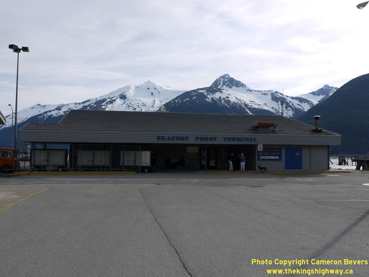
Left - Scenic Taiya Inlet as seen from the southern terminus of the Klondike Highway (Hwy 98) at the Alaska Marine Highway System (AMHS) Ferry Terminal
in Skagway. This is as far inland as the AMHS ferry service travels, and as far south as one can travel by highway in the Skagway area. For motorists wishing to
travel south to Juneau (Alaska's state capitol), Skagway provides the most direct road access point to the Pacific Ocean from Canada and the Lower 48 States. Juneau
is rather unique, since it is the only state capitol in the United States that cannot be reached by highway. The city is only accessible by water or by air. The
Juneau area does have a small network of local highways, but these roads are all cut off from the contiguous North American highway system by the impenetrable Coast
Mountains. Skagway's scenic harbour is also a popular port-of-call for many Alaskan cruise ships. See an
Enlarged Photo Here. (Photograph taken on June 4, 2012 - © Cameron Bevers) Right - Alaska Marine Highway System (AMHS) Ferry Terminal at the southern terminus of the Klondike Highway (Hwy 98) in Skagway. The highway ends in Skagway, so it is not possible to drive any further south along the coast of the Pacific Ocean. To reach other Southeast Alaskan communities, motorists have to load their vehicles onto the AMHS ferry and head south towards Haines and Juneau. AMHS ferry service is also provided to other coastal cities, including Petersburg, Sitka and Ketchikan. A popular driving loop for tourists is to take the very scenic AMHS ferry route down Taiya Inlet from Skagway to Haines, where motorists can return to the Alaska Highway via the Haines Highway (Hwy 7). (Photograph taken on June 4, 2012 - © Cameron Bevers) 

Left - Facing north along the Klondike Highway (Hwy 98) from the Alaska Marine Highway System (AMHS) Ferry Terminal in Skagway. At a total length of only
15 miles, Hwy 98 is Alaska's shortest numbered state highway. It extends north from Skagway to the Canadian Border at White Pass. Skagway is the only town on the
American side of the border. Carcross and Whitehorse both lie across the Canadian Border in Yukon Territory. In fact, the only way to reach Skagway by road is through
Canada's Yukon Territory. Interestingly, distances are shown on this sign in both Metric and Imperial measurements. See an
Enlarged Photo Here. (Photograph taken on June 4, 2012 - © Cameron Bevers) Right - Approaching the Alaska Marine Highway System (AMHS) Ferry Terminal on the Klondike Highway (Hwy 98) in Skagway, facing south. See an Enlarged Photo Here. (Photograph taken on June 4, 2012 - © Cameron Bevers) 

Left - Facing north along the Klondike Highway (Hwy 98) at the White Pass & Yukon Railroad crossing in Skagway. Constructed in the 1890s, this interesting
narrow-gauge railroad carried Klondike Gold Rush stampeders north into Canada's Yukon Territory by the thousands. See an
Enlarged Photo Here. (Photograph taken on June 4, 2012 - © Cameron Bevers) Right - The White Pass & Yukon Railroad is a narrow-gauge railroad, constructed to fit through the limited space at White Pass. When the railroad was completed through White Pass in 1899, it bypassed the perilous journey up the steep trails through the mountains, which earlier stampeders had to do on foot. The railroad was completed to Whitehorse in 1900, greatly improving access to this remote region of Canada. Almost 80 years would pass before the Klondike Highway was completed between Skagway and Whitehorse. The highway finally opened to traffic in 1979. Skagway's beautiful "frontier town" skyline is particularly photogenic against the forested mountains in the background. See an Enlarged Photo Here. (Photograph taken on June 4, 2012 - © Cameron Bevers) 

Left - A White Pass & Yukon Railroad passenger train crosses the Klondike Highway (Hwy 98) in Skagway. See an
Enlarged Photo Here. (Photograph taken on June 5, 2012 - © Cameron Bevers) Right - White Pass & Yukon Railroad locomotives in Downtown Skagway. The railroad more or less parallels the Klondike Highway between Skagway and Whitehorse. (Photograph taken on June 5, 2012 - © Cameron Bevers) 

Left - The old-fashioned passenger coaches of the White Pass & Yukon Railroad are a delight for the many tourists who board this train for the scenic
journey from Skagway up to White Pass. The scenic railroad is one of Skagway's major tourist attractions. (Photograph taken on June 5, 2012 - © Cameron Bevers) Right - Facing north along Broadway towards First Avenue in Downtown Skagway. Here, the Klondike Highway (Hwy 98) turns west for one block. The turn-off is merely marked by a green guide sign for Whitehorse. Skagway's historic district can be found straight ahead along Broadway. See an Enlarged Photo Here. (Photograph taken on June 4, 2012 - © Cameron Bevers) 

Left - Skagway's historic Broadway offers visitors a fascinating trip into the past - back to a time when Skagway was a notorious, violent frontier town and
supply post serving hopeful Klondike prospectors. Most of the historic downtown area is part of Klondike Gold Rush National Historic Park, which boasts a large number
of well-preserved gold rush-era buildings. The Klondike Highway (Hwy 98) turns west for one block and follows adjacent State Street in order to bypass the crowded
downtown streets. Broadway is a very busy tourist area, with lots of pedestrian traffic. Skagway is an absolute must-see for Alaska tourists and history enthusiasts.
See an Enlarged Photo Here. (Photograph taken on June 4, 2012 - © Cameron Bevers) Right - Sign on the Klondike Highway (Hwy 98) entering Downtown Skagway, marking the boundary to the Klondike Gold Rush National Historic Park. (Photograph taken on June 5, 2012 - © Cameron Bevers) 

Left - A late evening view of Broadway in Downtown Skagway. Even in Southeast Alaska, the sun stays up until nearly 10:30 pm in summer. See an
Enlarged Photo Here. (Photograph taken on June 4, 2012 - © Cameron Bevers) Right - Facing west on First Avenue in Skagway, approaching State Street. Hwy 98 resumes its route north towards the Canadian Border one block west of Broadway. It is nearly impossible to get lost in Skagway, since the entire town is only four blocks wide. The town is located in a deep valley, sandwiched between two mountain ranges. See an Enlarged Photo Here. (Photograph taken on June 4, 2012 - © Cameron Bevers) 

Left - Another green guide sign for Whitehorse marks the Hwy 98 turn-off from First Avenue to State Street in Skagway. Whitehorse is the capitol city of
Canada's Yukon Territory. (Photograph taken on June 4, 2012 - © Cameron Bevers) Right - Klondike Highway (Hwy 98) turn-off from First Avenue to State Street in Skagway, facing west. (Photograph taken on June 5, 2012 - © Cameron Bevers) 
Above - This Alaska Highway 98 route marker is the only one along the entire highway. The highway's route number is an obvious historical reference to the
"Trail of '98", when tens of thousands of frenzied prospectors stampeded through the Skagway area on their route north to the Klondike region in Yukon. At the peak
of the gold rush in 1898, Klondike stampeders had the choice of two trails leading through the mountains. One trail started in Skagway and headed north into Canada
via White Pass, while the other led from Dyea through Chilkoot Pass. Both trails were steep, difficult and dangerous. Many unfortunate stampeders perished on the
trail before ever reaching Canada, while countless others were turned away at the Canadian Border if they were not properly equipped for the journey. Once the
Klondike stampeders crossed into Canada, the balance of the journey to Dawson City could be done via boat along the broad Yukon River. The Yukon River's source lies
just across the Coast Mountains. Today, the 440-mile journey between Skagway and Dawson City can be done by car with considerable ease via the Klondike Highway. (Photograph taken on June 5, 2012 - © Cameron Bevers) 

Left - Facing south along Hwy 98 (State Street) at First Avenue. Here, the Klondike Highway turns left for one block before heading south again towards the
AMHS Ferry Terminal. Note the green guide sign for the ferry at right. Beautiful Halutu Ridge climbs to an elevation of over 5,200 feet on the far side of Taiya
Inlet. See an Enlarged Photo Here. (Photograph taken on June 4, 2012 - © Cameron Bevers) Right - Facing north along State Street (Hwy 98) from First Avenue. The Klondike Highway passes through the built-up portion of Skagway, but bypasses the historic downtown area. One would never guess from the deceptively flat topography of State Street that the highway ahead climbs 3,300 feet in elevation before it reaches the Canadian Border only 14 miles away. There are no gas stations along the Klondike Highway between Skagway and Carcross, Yukon. You will want to fill up before leaving town. See an Enlarged Photo Here. (Photograph taken on June 4, 2012 - © Cameron Bevers) 

Left - Facing south along the Klondike Highway (Hwy 98) as the route turns from 23rd Avenue onto State Street in Skagway. See an
Enlarged Photo Here. (Photograph taken on June 4, 2012 - © Cameron Bevers) Right - Approaching Skagway on the Klondike Highway (Hwy 98), facing south near Milepost 2. See an Enlarged Photo Here. (Photograph taken on June 4, 2012 - © Cameron Bevers) 

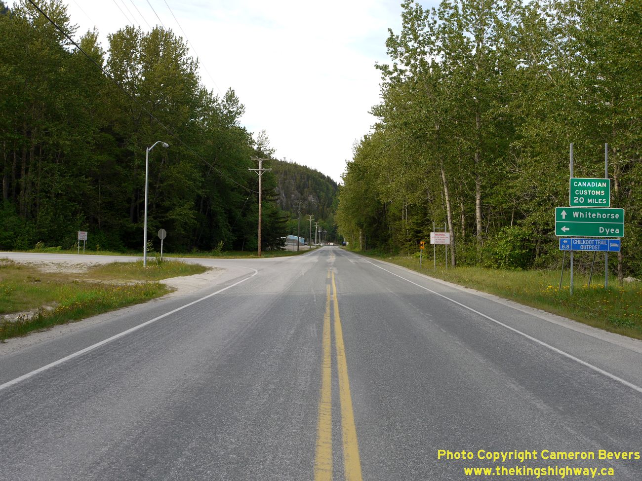
Left - Facing north along the Klondike Highway (Hwy 98) at the Dyea Road Junction north of Skagway. This road leads to the Klondike Gold Rush-era ghost town
of Dyea, which was abandoned in 1899 after the completion of the White Pass & Yukon Railroad from Skagway to Lake Bennett. Once a worthy adversary of Skagway,
Dyea began to decline rapidly after a deadly avalanche on the Chilkoot Trail's "Golden Staircase" in April, 1898, which killed dozens of Klondike stampeders. The
safety of the Chilkoot Trail came under increased scrutiny after the 1898 avalanche, and gold rush stampeders quickly began to opt for the less steep White Pass Trail
instead. Today, Dyea is home to a scenic park, a campground, and a historic cemetery where many of the victims of the 1898 avalanche were laid to rest. See an
Enlarged Photo Here. (Photograph taken on June 4, 2012 - © Cameron Bevers) Right - Facing south along the Klondike Highway (Hwy 98) towards Skagway approaching the Dyea Road Junction. This is the only road junction north of Skagway that leads anywhere of significance. Most roads leading off of Hwy 98 dead-end very shortly after branching off the main highway. The Dyea Road also dead-ends at a campground about 9 miles away, at the end of Taiya Inlet. The Klondike Highway ends 2 miles to the south, at the very harbour that many of the stampeders arrived at before their perilous journey north to the Klondike Gold Fields of Dawson City, Yukon. See an Enlarged Photo Here. (Photograph taken on June 4, 2012 - © Cameron Bevers) 

Left - Closure gate on the Klondike Highway (Hwy 98) north of Skagway. These gates can be lowered in the event of emergency highway closures. During summer,
the border crossing between Skagway, Alaska and Fraser, British Columbia is open 24 hours a day, 7 days a week. However, from November 1st to March 31st, the border
crossing at Fraser is only open from 8:00 am to Midnight (Yukon Time) or 7:00 am to 11:00 pm (Alaska Time). See an
Enlarged Photo Here. (Photograph taken on June 4, 2012 - © Cameron Bevers) Right - The Klondike Highway (Hwy 98) begins its steep ascent towards the Canadian Border at White Pass about 3 miles north of Skagway. Over the next 11 miles, the highway climbs almost 3,300 feet in elevation. This is the last intersection in Alaska before the Klondike Highway crosses the Canadian Border. See an Enlarged Photo Here. (Photograph taken on June 4, 2012 - © Cameron Bevers) 

Left - Facing south along the Klondike Highway (Hwy 98), about 3 1/2 miles north of Skagway. See an
Enlarged Photo Here. (Photograph taken on June 4, 2012 - © Cameron Bevers) Right - The Klondike Highway (Hwy 98) passes tiny Black Lake near Milepost 4 on its route south towards Skagway. See an Enlarged Photo Here. (Photograph taken on June 4, 2012 - © Cameron Bevers) 

Left - Facing south along the Klondike Highway (Hwy 98) towards Skagway. Note the lack of shoulders along this highway. See an
Enlarged Photo Here. (Photograph taken on June 4, 2012 - © Cameron Bevers) Right - Roadside turnout on the Klondike Highway (Hwy 98) north of Skagway. This steep grade proves to be troublesome for some vehicles. These turnouts provide a refuge for slower vehicles to pull over and let other vehicles pass. State law in Alaska actually requires drivers of slow-moving vehicles to use the turnouts if a queue of vehicles begins to form on the highway behind them. See an Enlarged Photo Here. (Photograph taken on June 4, 2012 - © Cameron Bevers) 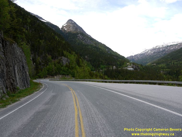

Left - This sharp reverse curve appears about 5 miles north of Skagway along the Klondike Highway (Hwy 98), as the route winds north towards the Canadian
Border at White Pass. See an Enlarged Photo Here. (Photograph taken on June 4, 2012 - © Cameron Bevers) Right - This steep-walled canyon drops off precipitously, mere inches from the side of the Klondike Highway (Hwy 98) north of Skagway. Note the White Pass and Yukon Route Railroad tracks on the opposite side of the canyon. See an Enlarged Photo Here. (Photograph taken on June 4, 2012 - © Cameron Bevers) 

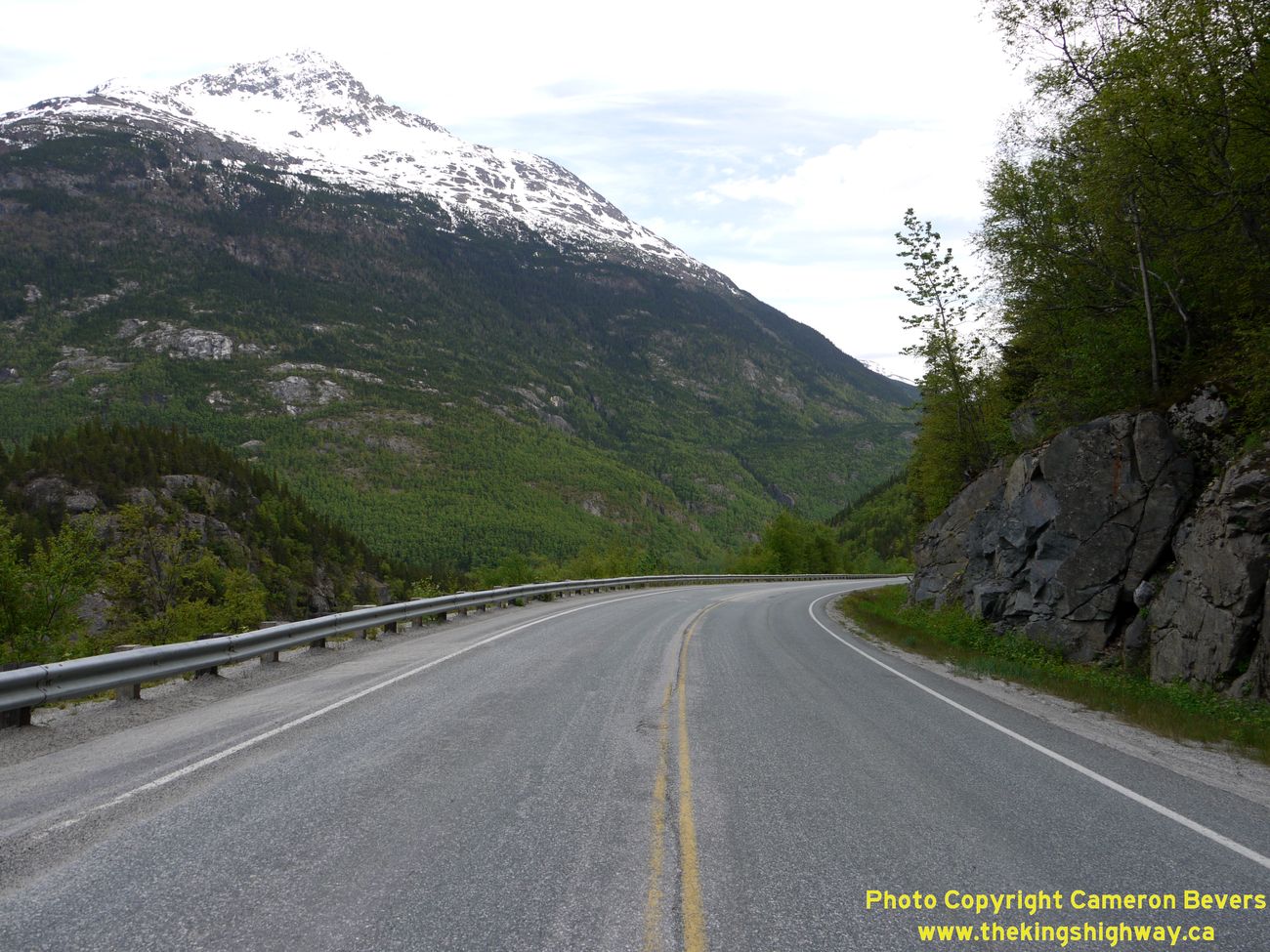
Left - The Klondike Highway (Hwy 98) passes the Twin Dewey Peaks on its route south towards Skagway. See an
Enlarged Photo Here. (Photograph taken on June 4, 2012 - © Cameron Bevers) Right - The Klondike Highway (Hwy 98) clings precariously to the side of the mountain north of Milepost 5. Although it is only 15 miles in length, Hwy 98 is one of Alaska's most dramatic state highways. See an Enlarged Photo Here. (Photograph taken on June 4, 2012 - © Cameron Bevers) 

Left - Mountains tower over the Klondike Highway (Hwy 98), about 6 miles north of Skagway. See an
Enlarged Photo Here. (Photograph taken on June 4, 2012 - © Cameron Bevers) Right - The dramatic views start to unfold along the southbound Klondike Highway (Hwy 98) as the highway passes the 900 foot elevation mark near Milepost 6. See an Enlarged Photo Here. (Photograph taken on June 4, 2012 - © Cameron Bevers) 

Left - Approaching the United States Customs House on the Klondike Highway (Hwy 98). The customs office is roughly 6 1/2 miles north of Skagway. Tourists who
wish to take in the spectacular scenic lookouts at White Pass must bring their passports along with them, as they will have to pass back through US Customs on their
return to Skagway. See an Enlarged Photo Here. (Photograph taken on June 4, 2012 - © Cameron Bevers) Right - Facing north along the Klondike Highway (Hwy 98) beyond the United States Customs House at Milepost 7. From here, the Klondike Highway winds its way north across White Pass to the Canadian Border. The Canadian Customs House lies about 15 miles ahead. See an Enlarged Photo Here. (Photograph taken on June 5, 2012 - © Cameron Bevers) 

Left - Facing south along the Klondike Highway (Hwy 98) towards Skagway north of the United States Custom House. The mountains of Taiya Inlet are still
visible on the horizon, although they disappear from view as the highway rounds this curve near Milepost 7. See an
Enlarged Photo Here. (Photograph taken on June 5, 2012 - © Cameron Bevers) Right - Klondike Highway (Hwy 98) near Milepost 8, facing north towards the Canadian Border. This highway has numerous roadside turnouts due to the excessively long and steep mountain grade. The Klondike Highway climbs from the north end of Skagway, which is essentially at Sea Level, to almost 3,300 feet in elevation in under 12 miles. See an Enlarged Photo Here. (Photograph taken on June 5, 2012 - © Cameron Bevers) 

Left - Snow posts begin on the Klondike Highway (Hwy 98) near Milepost 8. This area receives an excessive snowfall each winter. To help guide motorists (and
snowplows) in winter weather, these steel posts are coated with reflective sheeting, so that the edge of the road can be discerned from the snowy surroundings. You
really wouldn't want to miss the edge of the road while driving up this canyon. See an
Enlarged Photo Here. (Photograph taken on June 5, 2012 - © Cameron Bevers) Right - Facing north along the Klondike Highway (Hwy 98) towards the Canadian Border at White Pass. See an Enlarged Photo Here. (Photograph taken on June 5, 2012 - © Cameron Bevers) 

Left - Facing south along the Klondike Highway (Hwy 98) towards Skagway from Milepost 9. See an
Enlarged Photo Here. (Photograph taken on June 5, 2012 - © Cameron Bevers) Right - Melting snow on the mountainside created this beautiful cascade beside the Klondike Highway (Hwy 98) near Milepost 9. See an Enlarged Photo Here. (Photograph taken on June 5, 2012 - © Cameron Bevers) 

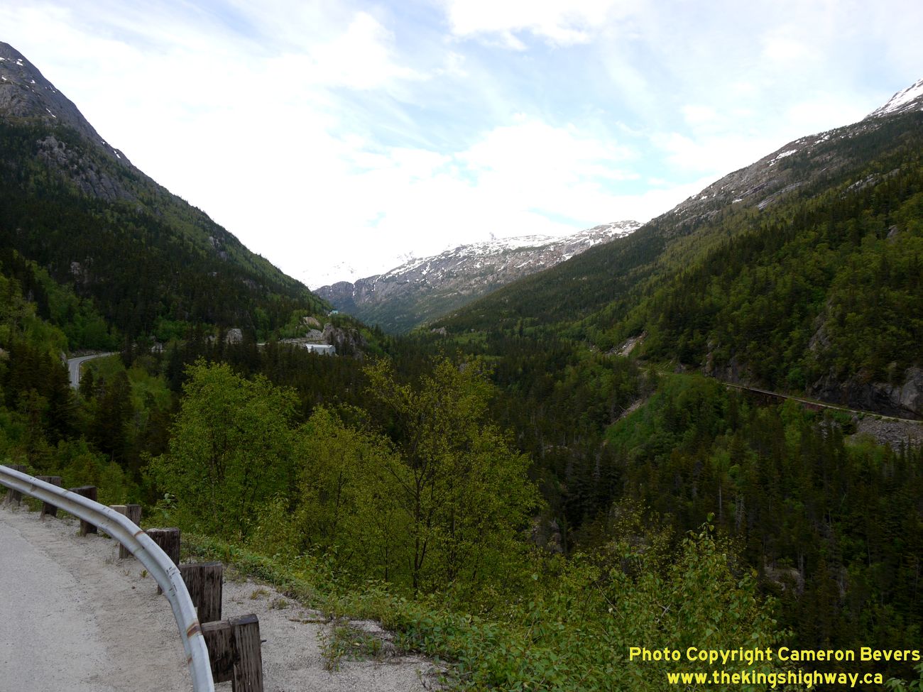
Left - View of the Skagway River from the Roadside Turnout near Milepost 9 on the Klondike Highway (Hwy 98). It is quite the drop down into the canyon from
here! See an Enlarged Photo Here. (Photograph taken on June 5, 2012 - © Cameron Bevers) Right - This interesting view of the canyon shows the paths of two transportation arteries: The grade of the Yukon and White Pass Railroad can be seen climbing the eastern side of the canyon, while the Klondike Highway can be seen climbing the western side of the canyon. See an Enlarged Photo Here. (Photograph taken on June 5, 2012 - © Cameron Bevers) 

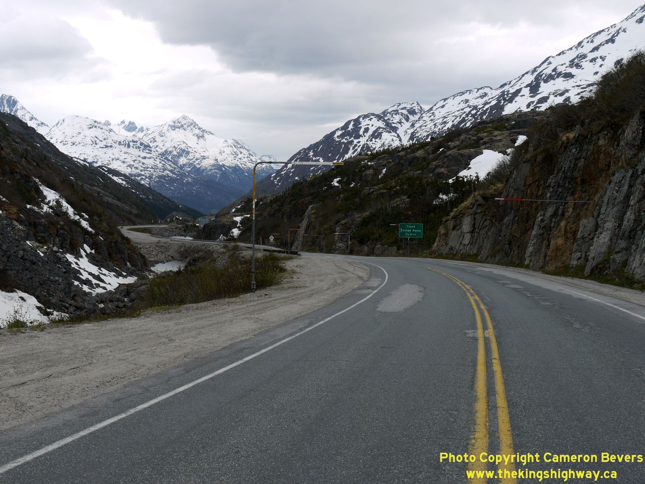
Left - Runaway truck ramp sign near Milepost 10 on the Klondike Highway (Hwy 98). Note the sign warning drivers not to stop on the highway, due to an
avalanche hazard. (Photograph taken on June 5, 2012 - © Cameron Bevers) Right - Facing south along the Klondike Highway (Hwy 98) about 10 miles north of Skagway. In order to construct a highway through White Pass, highway engineers had to accept that for 6 miles, the highway would climb a tortuous 8% grade. While this is normally not an ideal highway design, the mountainous topography in the area made it absolutely impossible to mitigate the long, steep gradient. See an Enlarged Photo Here. (Photograph taken on June 5, 2012 - © Cameron Bevers) 

Left - Approaching the runaway truck ramp near Milepost 10 on the Klondike Highway (Hwy 98), facing south towards Skagway. See an
Enlarged Photo Here. (Photograph taken on June 5, 2012 - © Cameron Bevers) Right - View of the mountainous route of the Klondike Highway (Hwy 98) about 10 miles north of Skagway. See an Enlarged Photo Here. (Photograph taken on June 5, 2012 - © Cameron Bevers) 

Left - Approaching the Captain William Moore Bridge on the Klondike Highway (Hwy 98), facing north towards White Pass. See an
Enlarged Photo Here. (Photograph taken on June 5, 2012 - © Cameron Bevers) Right - Facing south along the Klondike Highway (Hwy 98) at the Captain William Moore Bridge at Milepost 11. This impressive cable-stayed structure was completed in 1976, completing a critical link in the Klondike Highway across William Moore Creek. This deep canyon, which is also the location of an seismically active geological fault, had foiled earlier engineering attempts to construct a highway across White Pass. See an Enlarged Photo Here. (Photograph taken on June 5, 2012 - © Cameron Bevers) 

Left - View of the Captain William Moore Bridge on the Klondike Highway (Hwy 98). It is only from this angle that one can appreciate what a remarkable
engineering feat that this bridge truly is - an impressive, 250-foot asymmetrical cable-stayed structure which spans an active geological fault line. The structure is
cantilevered from only one side of the fault, so that in the event of a seismic event, the bridge deck is not subjected to any lateral shifting. Note the highway
coach bus at right for scale. See an Enlarged Photo Here. (Photograph taken on June 5, 2012 - © Cameron Bevers) Right - The location of the geologic fault spanned by the Captain William Moore Bridge on the Klondike Highway (Hwy 98) in quite obvious in this photo. See an Enlarged Photo Here. (Photograph taken on June 5, 2012 - © Cameron Bevers) 

Left - Skagway River Valley, as seen from the lookout on the Klondike Highway (Hwy 98) near Milepost 11. The view of the valley from this point is absolutely
breathtaking! The mountains literally fall away at your feet, cascading down towards the Pacific Ocean at Skagway. See an
Enlarged Photo Here. (Photograph taken on June 5, 2012 - © Cameron Bevers) Right - Facing south along the Klondike Highway (Hwy 98) at Milepost 12. A second runaway truck ramp exists at this point. See an Enlarged Photo Here. (Photograph taken on June 5, 2012 - © Cameron Bevers) 

Left - Approaching the runaway truck ramp on the Klondike Highway (Hwy 98), facing south about 12 miles north of Skagway. See an
Enlarged Photo Here. (Photograph taken on June 5, 2012 - © Cameron Bevers) Right - And still it climbs - The Klondike Highway (Hwy 98) continues its dramatic ascent up White Pass from Skagway towards the Canadian Border. See an Enlarged Photo Here. (Photograph taken on June 5, 2012 - © Cameron Bevers) 

Left - This sweeping reverse curve on the Klondike Highway (Hwy 98) lies about 13 miles north of Skagway. Note the runaway truck ramp at right. See an
Enlarged Photo Here. (Photograph taken on June 5, 2012 - © Cameron Bevers) Right - The Klondike Highway (Hwy 98) winds its way up through White Pass towards the summit and the Canadian Border. See an Enlarged Photo Here. (Photograph taken on June 5, 2012 - © Cameron Bevers) 

Left - A rare tangent section on the Klondike Highway (Hwy 98) near White Pass. This incredibly short state highway is less than 15 miles in length. See an
Enlarged Photo Here. (Photograph taken on June 5, 2012 - © Cameron Bevers) Right - The geometry of the Klondike Highway (Hwy 98) through the White Pass is very constrained. Highway builders constructed this highway in any way they could, meandering around unstable rocky slopes and steep cliffs. Although the speed limit on the Klondike Highway is 40 mph, one should always drive according to conditions. See an Enlarged Photo Here. (Photograph taken on June 5, 2012 - © Cameron Bevers) 

Left - White-knuckling it through White Pass - the Klondike Highway's route through White Pass is not an easy drive. Although it is a paved state highway, it
must be negotiated with extreme caution. The highway twists and turns on a narrow ledge through this canyon, after which it drops precipitously in elevation towards
the Pacific Ocean. See an Enlarged Photo Here. (Photograph taken on June 5, 2012 - © Cameron Bevers) Right - The frozen, icy landscape of White Pass is quite the sight to see. After seeing this appallingly desolate mountain landscape first-hand, it is little wonder that it took until the late 1970s to construct a highway through this barren canyon. The fact that Klondike prospectors hiked up this pass on foot by the thousands in the late 1890s is a true testament to mankind's determination! See an Enlarged Photo Here. (Photograph taken on June 5, 2012 - © Cameron Bevers) 

Left - Sign marking the summit at White Pass. At an elevation of 3,292 feet above sea level, it is one of the highest mountain passes on the Alaska State
Highway System. It is also perhaps the least forgiving. Even in June, the numbing, frigid winds came howling through this pass, in stark contrast to the balmy
spring temperatures in nearby Skagway. What a shock this climate must have been for those poor souls who attempted to hike through this pass in the 1890s on their
way to the Klondike, chasing their golden dreams. See an Enlarged Photo Here. (Photograph taken on June 5, 2012 - © Cameron Bevers) Right - At the summit of White Pass, the Klondike Highway (Hwy 98) crosses the border into Canada. The international boundary is merely marked by a small green sign at right and a gate on the left. Canada's Customs House lies in Fraser, about 7 miles ahead. The United States and Canadian Customs Houses are thus separated by 15 miles, due to the extremely inhospitable climate at the mountain pass itself. This creates an interesting "No Man's Land", whereby you've seemingly left the United States, but haven't yet entered Canada. See an Enlarged Photo Here. (Photograph taken on June 5, 2012 - © Cameron Bevers) 

Left - Facing south along the Klondike Highway (Hwy 98) towards Skagway from the Canadian Border. Note the "Welcome to Alaska" sign at right. See an
Enlarged Photo Here. (Photograph taken on June 5, 2012 - © Cameron Bevers) Right - Facing north along the Klondike Highway as it crosses into Canada at White Pass. Here, Alaska's Highway 98 comes to an end. The Klondike Highway's route continues north into Canada as Hwy 2. The section of the Klondike Highway immediately north of White Pass is actually situated within the Canadian province of British Columbia. However, the only place that this highway leads once it departs from Alaska is into Canada's Yukon Territory. The Klondike Highway does not connect to any highways in British Columbia, nor does it pass through any communities in that province. Accordingly, the route of the Klondike Highway through British Columbia is signed as if it was a Yukon Territorial Highway. See an Enlarged Photo Here. (Photograph taken on June 5, 2012 - © Cameron Bevers) 
Above - Guide sign for the Klondike Highway (Hwy 2) at the border between Canada and the United States at White Pass. Yukon's highway signs are rather
interesting. Territorial Highways in Yukon are marked using a signboard showing mileages along with both a numeric and pictorial route identification marker.
Distances on these signs are shown in kilometres, not miles. To convert to miles, divide these figures by 1.61. For example, the distance to Whitehorse is about 97
miles. The Canadian Customs House lies at Fraser, 12 km ahead (about 7 miles). The Klondike Highway's pictorial symbol features a turn-of-the-century Klondike
prospector, panning for gold. The colour of the route marker? You guessed it - gold! See an
Enlarged Photo Here. (Photograph taken on June 5, 2012 - © Cameron Bevers) |
|---|
Links to Other Ontario Highway History Website Sections:
Back to Alaska Highway 11 Photos /
Alaska Highways Photo Index /
On to Alaska Marine Highway System Photos
Vacation Highway Photos - Main Menu / Ontario Highway History - Main Menu Website contents, photos & text © 2002-2026, Cameron
Bevers (Webmaster) - All Rights Reserved / Contact Me
|
|---|