Hwy 39 Sign Graphic About Me Page Title Graphic Hwy 82  Sign Graphic   

So, who is this guy that runs thekingshighway.ca website?:

Hello! My name is Cameron Bevers and I live near Barrie, Ontario. I have been interested in roads and maps for about as long as I can remember. In recent decades, I have become particularly fascinated by the history of Ontario's highway system. I have always enjoyed travelling throughout Ontario, and I have taken numerous photographs of some unusual sights and places on the province's highways. I have now completely driven the entire 21,500 km provincial highway network of Ontario, a personal goal which took me several years to finish off. I completed my last section of the Ontario highway network near Rainy River (Hwy 600) in September 2006.


Photo at Right: Taking a break from the road at the scenic Agawa Bay Lookout on Hwy 17, Lake Superior
CAM AT THE AGAWA BAY LOOKOUT

What I Do Otherwise:

In 2009, I graduated from the Transportation Engineering Technology (Honours) program at Mohawk College in Hamilton. I have been employed with the Ontario Ministry of Transportation since 2009 in various professional roles in both the Highway Engineering and Traffic Engineering Divisions in Downsview. I am currently working as a Traffic Supervisor in MTO's Eastern Region, where I lead a team of traffic engineering professionals. However, this website is strictly a personal interest project of mine. It is not affiliated with, nor is it endorsed/sponsored by MTO. My interests in Ontario's Highways extend far beyond my professional life. For me, Ontario's highway history is also a hobby. I am an avid collector of Ontario's early highway maps, highway photographs, highway signs and license plates. Whenever I am not developing my professional career or working on this website, you'll likely find me out boating, going camping, playing ice hockey, reading, and most importantly - driving around and exploring the province's highways! If you happen to see me out on the highways doing my photography, please feel free to stop and say hi!


Photo at Right: Exploring the abandoned route of Hwy 17 across Cavers Hill between Schreiber and Nipigon
CAM EXPLORING CAVERS HILL

How This Website Came Together:

My idea of putting together a website to document the history of Ontario's Highways came about in the Fall of 2001. At the time, there was very little information available online about Ontario's Highways, so I set out to change all of that! After about six months of initial research and some crude webpage designs, the website finally launched on September 4, 2002. Originally, my website was mostly a text-based history, rather than a visual one. In the early years of the Internet, bandwidth and limited downloading speeds made hosting a website rich in photos very problematic. However, as the Internet matured and the transmittal of data became less of a problem, I was able to expand the website to also offer a visual history of Ontario's Highways told through both historical and present day photos. The website has steadily grown over the years and has actually become so big now that at times it seems unmanageable for one person to administer. Yet somehow, I manage to keep up with a few updates a month, despite a full-time career, busy personal and family life along with all my other activities and interests. Today, this website welcomes tens of thousands of visitors each month seeking to explore The King's Highways of Ontario - both past and present. I hope you enjoy your visit!


Photo at Right: Winter sanding operations along an icy section of the Queen Elizabeth Way near Port Credit (1940)
(Photo courtesy of Ontario Ministry of Transportation  -  © King's Printer for Ontario, 1940)
WINTER SANDING OPERATIONS ON THE QEW

Me Doing My "Highways Thing":

I am not even going to try to convince you that there is anything "normal" about my strange hobby. I know that what I do is weird. I am often the recipient of confused and curious glances from passers-by when I am out doing my field research. Admittedly, taking photographs of old bridges, culverts and chewed-up pieces of abandoned road pavement is not what most people would call interesting historical research. For me, it is a hunt for tangible history - a sort of modern-day "transportation archaeology", if you wish. Most people are not aware of the amount of history that surrounds Ontario's highways, which is unfortunate given the important role that our highways have played in the province's development. I'm certain that many people could care less about the history of our highways. However, if you are reading these words, you have clearly located my website out there in cyberspace and the topic of highway history obviously intrigues you to at least some extent.

History as a whole has always been one of my main interests. It was one of my university majors, so it seemed fitting to construct a historical website on a topic that I really enjoy. About half of my research time is spent on the roads of Ontario, looking for pieces of history that have been more or less forgotten. I tend to take a lot of photographs of my historical "finds", as one should never assume that these historical features will be around forever. Time is slowly taking its toll on much of Ontario's transportation heritage. I hope that this website will help to preserve and document the changes to the King's Highway System as the years pass.


CAM EXPLORING A BRIDGE NEAR WAWA             SCENIC VIEW ALONG HWY 11 NORTH OF NIPIGON

Left - Stopping for a photo at a historic timber truss bridge over the Magpie River southwest of Wawa

Right - View of Hwy 11 north of Nipigon - One of many thousands of photos which I've taken of the King's Highways over the years


CAM AT OUIMET CANYON             CAM AT BRONTE BRIDGE

Left - Enjoying the views at Ouimet Canyon Provincial Park northeast of Thunder Bay

Right - Exploring the mighty Bronte Bridge on the Queen Elizabeth Way in Oakville


CAM AT THE SYDNEY CREEK BRIDGE NEAR ELK LAKE             CAM AT 1000 ISLANDS PKWY

Left - Me posing with a historic timber truss bridge constructed in 1936 on Hwy 65 near Elk Lake

Right - Exploring an old culvert from the 1930s under the Thousand Islands Parkway near Gananoque


A Quest Finally Accomplished:

For as long as I can remember, I have stared at Ontario road maps wondering what was at the end of Hwy 599. This highway is Ontario's northernmost provincial highway, which extends nearly 300 kilometres north from Ignace to the old gold mining towns of Central Patricia and Pickle Lake. Ever since I was a kid, I have wanted to drive to the end of Hwy 599. I vowed that I would do it as soon as a got my driver's license at the age of 16. Unfortunately, reality set in after I got my license. First of all, I didn't own a car, nor did I have the money to make the 1,700 kilometre trip (each way) to Ignace just to get to the beginning of Hwy 599. When I finished university, I began exploring Northern Ontario. I had made it a tradition of venturing to Northern Ontario every August. Each year, I ventured a little further north and west. In 2001, I finally made it to Ignace for the first time. However, poor weather and a lack of time forced me to postpone my trip to the end of Hwy 599. On my 
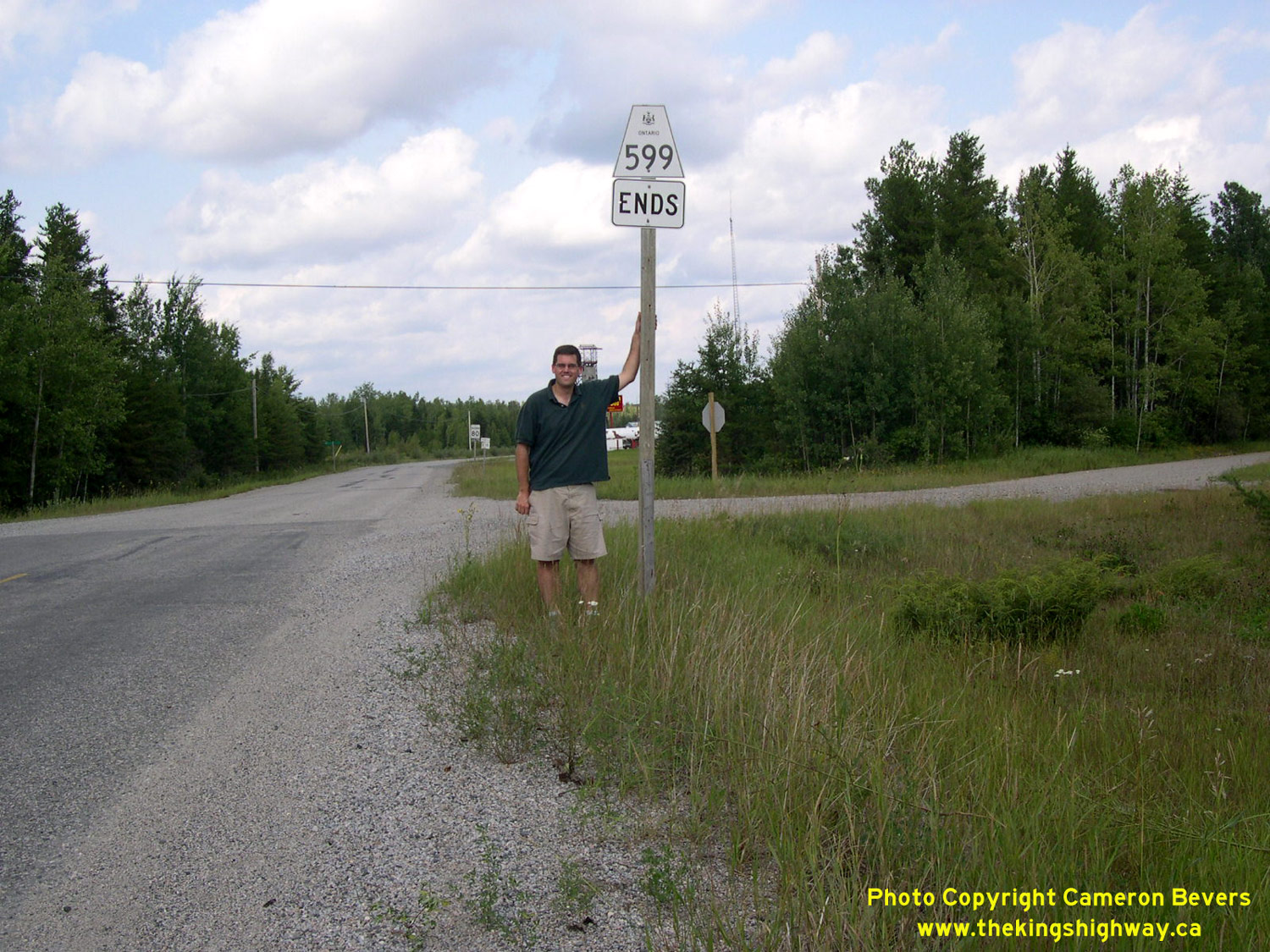
next visit to the Ignace area in 2003, I made it a priority to drive Hwy 599 from end-to-end. On August 24, 2003, I finally drove past the "Hwy 599 Ends" sign shown here, ending a long-standing desire to see what was at the end of Hwy 599.


Photo at Right: I finally did it!! Reaching the end of Ontario's northernmost highway (Hwy 599) was a long-standing goal (2003)
CAM AT END OF HWY 599

And Then There Was Armstrong:

Armstrong was another place that I had always wanted to drive to. After conquering Hwy 599 in 2003, I set my sights on Armstrong, located about 250 km north of Thunder Bay. Armstrong is actually located further south than other northern communities with provincial highway access, such as Aroland, Savant Lake and the Red Lake area. However, when compared to Hwy 599, the highway access to Armstrong is equivalently desolate. In 2004, I was vacationing in the Thunder Bay area when I decided it was time to complete Hwy 527. I did actually drive a portion of Hwy 527 back in 2001, but I did not have enough time on that trip to complete the highway. I finally completed the 240 km highway to Armstrong on September 2, 2004.


Photo at Right: Another milestone! Me standing beside the Hwy 527 Ends sign at Armstrong (2004)
CAM AT END OF HWY 527

The Very Last Mile:

In 2001, I had decided to systematically drive all of Ontario's provincial highways from end-to-end. At that time, I had completed about 60% of Ontario's provincial highway system. By 2006, I only had a handful of highways left to drive. The longest outstanding provincial highway that I had left to accomplish was a section of Hwy 600 in Northwestern Ontario, up near Rainy River. I deliberately saved this segment for last. I did this because it was over 2,000 km from my home town of Waterloo (at that time, anyway), meaning that it was a particularly good "final" milestone to accomplish. During the Summer of 2006, I nibbled away at my other outstanding highway links. I finally completed the last leg in the Ontario provincial highway system (Hwy 600) at Rainy River on September 3, 2006. As far as I know, I am the only person in history who has actually completed the entire Ontario highway system.


Photo at Right: The very last mile of the Ontario highway system for me - Arriving at the end of Hwy 600 in Rainy River (2006)
CAM AT END OF HWY 600

Links to Other Ontario Highway History Website Sections:


Ontario Highway History - Main Menu    /     Historical Photos of Ontario's Highways


Website contents, photos & text © 2002-2025, Cameron Bevers (Webmaster) - All Rights Reserved  /   Contact Me


Valid HTML 4.01!   Valid CSS!