
| 
| |
|
|
This page contains historical and present day photos of Ontario's King's Highway 14. All photographs displayed on this page were taken by the Webmaster (Cameron
Bevers), unless specifically noted otherwise. Historical photographs are arranged in approximate chronological order, while present day photographs (Year 2000 to
date) are arranged by location from south to north. Click on any thumbnail to see a larger image!
Please note that the section of Highway 62 lying south of Foxboro was originally known as Highway 14 prior to 1984. All historical photos of Highway 14 from the Picton area northerly to Marmora are indexed under this page regardless of location, but please check the Highway 62 Photo Pages if you are looking for present day photos of Highway 14's pre-1984 route from the Foxboro area southerly towards the Picton area. Please note that all photographs displayed on this
website are protected by copyright. These photographs must not be reproduced, published,
electronically stored or copied, distributed, or posted onto other websites without
my written permission. If you want to use photos from this website, please
email me first for permission. Thank-you!
|
|---|
|
Historical King's Highway 14 Photographs
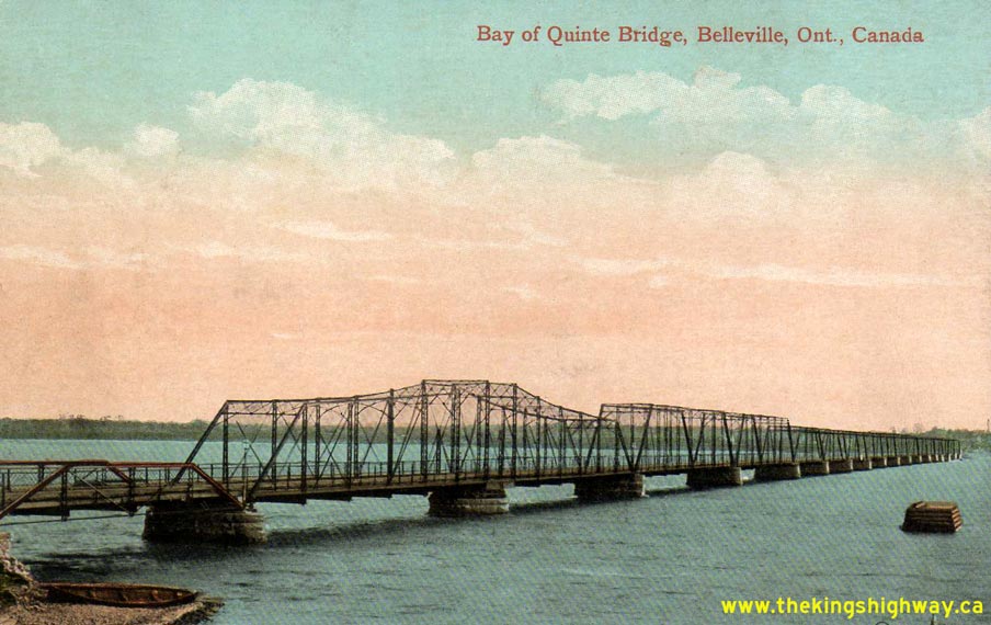

Left - Circa 1910 postcard view of the original Belleville Bay Bridge on Hwy 14. The structure shown above was completed as a toll bridge in 1890. It was
replaced by the Department of Public Highways in stages between 1927 and 1931 with new steel truss spans, a swing span, and a short causeway. This Belleville Bay
Swing Bridge was replaced with the current high-level structure (the Norris Whitney Bridge) in 1982. See an
Enlarged Photo Here. (Photo courtesy of The Valentine & Sons Publishing Company Ltd, Montreal & Toronto) Right - Circa 1930 postcard view of the new Moira River Bridge on Bridge Street (Hwy 2 & Hwy 14) in Downtown Belleville. The new bridge officially opened to traffic on August 4, 1930. See an Enlarged Photo Here. (Photo courtesy of The International Fine Art Company Ltd, Montreal) 
Above - Circa 1935 postcard view of Front Street (Hwy 14) in Downtown Belleville, facing north. See an
Enlarged Photo Here. (Photo courtesy of The International Fine Art Company Ltd, Montreal) 
Above - A Department of Highways' zone striping truck performing line painting operations on Hwy 14 near Mountain View south of Belleville in 1950. Pavement
markings were first introduced on Ontario's Highways in 1930. Originally, line paint was only used to mark the highway centreline approaching the crest of
hills on asphalt-surfaced highways. This was done to improve highway safety by encouraging motorists to stay in their own traffic lane in places where visibility of
oncoming traffic was restricted. No line paint was used on concrete-surfaced highways at first, as it was initially assumed that the centre construction joint between
the two concrete slabs provided adequate lane guidance to motorists. The use of line paint became much more prevalent on both concrete and asphalt-surfaced highways
by the end of the 1930s. However, line paint was still only warranted for use under certain traffic or geometric conditions. Line paint was introduced on narrow
highway pavements, sharp curves, approaching traffic signals and railway crossings, on multi-lane highways and on all heavily-traveled two-lane King's Highways. The
introduction of line paint was also helpful to mark safe passing zone opportunities on busy highways, hence why the Department of Highways originally called this
maintenance practice "zone painting" or "zone striping". As the King's Highway System became progressively busier after World War II, the painting of highway
centrelines just became a standard maintenance practice on all King's Highways. See an
Enlarged Photo Here. Photo taken on September 26, 1950. (Photo courtesy of Ontario Ministry of Transportation - © King's Printer for Ontario, 1950) 
Above - Circa 1960 postcard view of the Belleville Bay Bridge on Hwy 14. See an
Enlarged Photo Here. (Photo courtesy of L.F. Charter) 
Above - Roadway platform widening and reconstruction of Hwy 14 between Belleville and Foxboro (1963) (Photo courtesy of Ontario Ministry of Transportation - © King's Printer for Ontario, 1963) |
|---|
|
Present Day King's Highway 14 Photographs


Left - Palliser Creek Culvert on Ashley Street (Old Hwy 14) in Foxboro. See an
Enlarged Photo Here. (Photograph taken on August 16, 2008 - © Cameron Bevers) Right - A well-worn 1922 date stamp on the Palliser Creek Culvert in Foxboro. See an Enlarged Photo Here. (Photograph taken on August 16, 2008 - © Cameron Bevers) 

Left - Facing south along Ashley Street (Old Hwy 14) in Foxboro, approaching the Palliser Creek Culvert. See an
Enlarged Photo Here. (Photograph taken on August 16, 2008 - © Cameron Bevers) Right - Facing north along the Foxboro Bypass (Hwy 62) approaching the Hwy 14 Junction. See an Enlarged Photo Here. (Photograph taken on August 16, 2008 - © Cameron Bevers) 
Above - Junction assembly on northbound Hwy 62 approaching the Hwy 14 Junction near Foxboro. Up until the 1990s, Hwy 14 was a King's Highway which connected
Foxboro to Marmora, via Stirling. Jurisdiction over the highway was transferred from the province to the County of Hastings in 1996, who subsequently delegated
highway maintenance responsibilities to its various townships. See an Enlarged Photo Here. (Photograph taken on August 16, 2008 - © Cameron Bevers) 
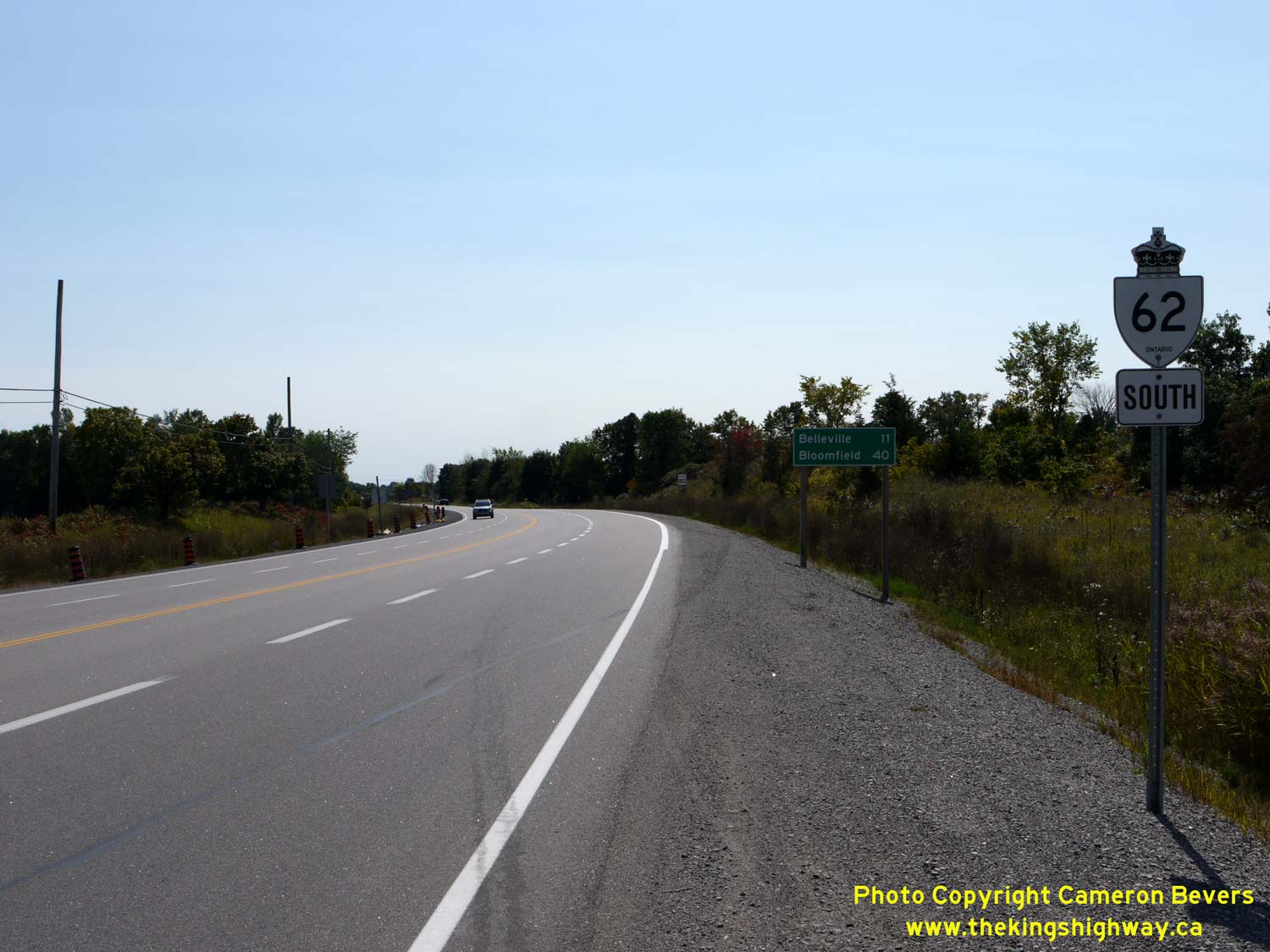
Left - Approaching the Hwy 62 & Hwy 14 Junction near Foxboro, facing north. The two highways intersect about 8 km north of the Hwy 401 Interchange. See an
Enlarged Photo Here. (Photograph taken on September 10, 2017 - © Cameron Bevers) Right - Facing south towards Belleville along the Foxboro Bypass (Hwy 62) from the Hwy 14 Junction. The Foxboro Bypass was opened to traffic on November 1, 1963. The new bypass allowed through traffic on Hwy 14 to bypass the community of Foxboro altogether. The bypass also provided more direct access to the well-traveled Foxboro-Madoc Road, a development road which was ultimately assumed by the province as an extension of Hwy 62 in 1966. See an Enlarged Photo Here. (Photograph taken on September 10, 2017 - © Cameron Bevers) 

Left - Facing north along Hwy 62 at the Hwy 14 Junction near Foxboro. From this junction, Hwy 14 heads northwesterly towards Stirling and Marmora via the
Foxboro-Stirling Road, while Hwy 62 continues straight ahead (north) towards Madoc and Bancroft. Prior to the completion of the Foxboro Bypass in 1963, the route of
Hwy 14 continued east from this intersection into Foxboro via Ducette Road. The channelized right turn ramp at left which carries southbound Hwy 14 traffic to
southbound Hwy 62 was completed during an intersection improvement project carried out in 1970. See an
Enlarged Photo Here. (Photograph taken on September 10, 2017 - © Cameron Bevers) Right - View of Ducette Road (Old Hwy 14) facing east from the Foxboro Bypass (Hwy 62). As originally established in the 1920s, Hwy 14 continued east into Foxboro and turned right at Ashley Street where the highway continued south towards Belleville. See an Enlarged Photo Here. (Photograph taken on September 10, 2017 - © Cameron Bevers) 

Left - Approaching the Foxboro Bypass (Hwy 62) on Ducette Road (Old Hwy 14) departing from Foxboro. Beyond the intersection, Hwy 14 follows the
Foxboro-Stirling Road northwesterly towards Stirling. See an Enlarged Photo Here. (Photograph taken on September 10, 2017 - © Cameron Bevers) Right - Southern terminus of Hwy 14 at the Hwy 62 Junction near Foxboro. Until 1963, Hwy 14 continued straight ahead via Ducette Road into Foxboro. See an Enlarged Photo Here. (Photograph taken on September 10, 2017 - © Cameron Bevers) 

Left - Green guide sign marking the Hwy 62 Junction at the southern terminus of Hwy 14 near Foxboro. Following the completion of the Foxboro Bypass in 1963,
Hwy 14 turned right at this intersection and proceeded directly towards Belleville. In an effort to simplify route numbering in the area, Hwy 14 was truncated at this
junction in 1984. In turn, Hwy 62 was extended south along the existing route of Hwy 14 between Foxboro and Bloomfield, via Belleville. See an
Enlarged Photo Here. (Photograph taken on September 10, 2017 - © Cameron Bevers) Right - Facing south along Hwy 62 approaching the Hwy 14 Junction near Foxboro. Prior to 1984, Hwy 62 reached its southern terminus at this highway junction. The through road continued south towards Belleville as Hwy 14. In an effort to simplify route numbering in the Belleville area, the southern leg of Hwy 14 between Foxboro and Bloomfield was renumbered as Hwy 62 in 1984. See an Enlarged Photo Here. (Photograph taken on September 10, 2017 - © Cameron Bevers) 

Left - Facing north along Hwy 62 towards Madoc from the Hwy 14 Junction near Foxboro. See an
Enlarged Photo Here. (Photograph taken on September 10, 2017 - © Cameron Bevers) Right - Old fingerboard guide signs at the Hwy 14 & Hwy 62 Junction on the Foxboro Bypass. See an Enlarged Photo Here. (Photograph taken on September 10, 2017 - © Cameron Bevers) 

Left - Facing north along Hwy 14 from the Foxboro Bypass (Hwy 62). Note that the Hastings County name has been covered over on this flowerpot route marker, as
this road is now maintained by the City of Quinte West. See an Enlarged Photo Here. (Photograph taken on September 10, 2017 - © Cameron Bevers) Right - Distance guide sign on northbound Hwy 14 (Foxboro-Stirling Road) near the Hwy 62 Junction. See an Enlarged Photo Here. (Photograph taken on September 10, 2017 - © Cameron Bevers) 

Left - Looking north along Hwy 14 from the Oak Hills towards Stirling. See an
Enlarged Photo Here. (Photograph taken on October 9, 2003 - © Cameron Bevers) Right - Abandoned alignment of Hwy 14 between Foxboro and Stirling. See an Enlarged Photo Here. (Photograph taken on October 9, 2003 - © Cameron Bevers) 

Left - This old curve on Hwy 14 at the southern entrance to Stirling was bypassed in the 1960s. It is now a municipal street named Elaine Crescent. See an
Enlarged Photo Here. (Photograph taken on August 17, 2008 - © Cameron Bevers) Right - Southern side of the Rawdon Creek Bridge on Front Street (Hwy 14) in Stirling. See an Enlarged Photo Here. (Photograph taken on August 17, 2008 - © Cameron Bevers) 

Left - Rawdon Creek Bridge on Front Street (Hwy 14) in Downtown Stirling, located immediately east of the Hwy 14 & Hwy 33 Junction. See an
Enlarged Photo Here. (Photograph taken on August 17, 2008 - © Cameron Bevers) Right - Northern side of the Rawdon Creek Bridge on Front Street (Hwy 14) in Stirling. This single-span steel beam bridge was completed in 1963. See an Enlarged Photo Here. (Photograph taken on August 17, 2008 - © Cameron Bevers) 

Left - Junction of Hwy 14 & Hwy 33 in Downtown Stirling, facing west. At this intersection, Hwy 14 turns right from Front Street onto North Street and
continues north from Stirling towards Marmora. Hwy 33 begins at this junction and continues straight ahead via Front Street. About 1 km ahead, Hwy 33 turns south
towards Frankford and Trenton. See an Enlarged Photo Here. (Photograph taken on August 17, 2008 - © Cameron Bevers) Right - Even though it is only a four-leg intersection, the traffic signals at the Hwy 14 & Hwy 33 Junction in Downtown Stirling have a very unusual layout. A third street (Mill Street) intersects Front Street and North Street at an angle within the intersection, which means that some directions of traffic have to move on their own dedicated signal phase. See an Enlarged Photo Here. (Photograph taken on August 17, 2008 - © Cameron Bevers) 

Left - Junction of Hwy 14 & Hwy 33 in Downtown Stirling, facing east along Front Street. Hwy 33 reaches its historical (pre-1996) northern terminus at this
highway junction. During the 1990s, jurisdiction over the entire route of Hwy 33 between Bloomfield and Stirling was transferred from the province to the Counties of
Prince Edward and Hastings. At the traffic signals, Hwy 14 South continues straight ahead towards Foxboro and Belleville via Front Street, while Hwy 14 North (at
left) heads north towards Marmora via North Street. See an Enlarged Photo Here. (Photograph taken on August 17, 2008 - © Cameron Bevers) Right - Facing north towards Marmora along North Street (Hwy 14) from the Hwy 33 Junction in Downtown Stirling. See an Enlarged Photo Here. (Photograph taken on August 17, 2008 - © Cameron Bevers) 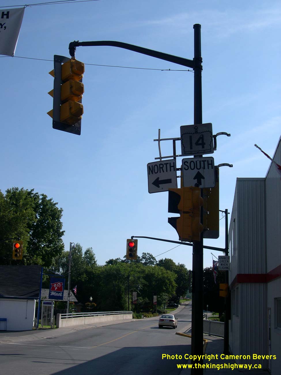
Above - Junction assembly at the northern terminus of Hwy 33 in Downtown Stirling. A lone King's Highway 14 junction crown sign still points south at this
junction. See an Enlarged Photo Here. (Photograph taken on August 17, 2008 - © Cameron Bevers) 

Left - Facing southwest along Mill Street approaching the Hwy 14 & Hwy 33 Junction in Downtown Stirling. This fourth intersection leg joins in at an angle,
which makes for a rather complicated traffic signal layout. Traffic using the north and northeast legs of this intersection must move on their own protected phase. No
Right Turn on Red prohibitions are in place on many of the intersection legs, to avoid potential conflicts with advancing traffic from one of the other intersection
legs. See an Enlarged Photo Here. (Photograph taken on August 17, 2008 - © Cameron Bevers) Right - Facing south along North Street (Hwy 14) at the Hwy 33 Junction (Front Street) in Downtown Stirling. From here, Hwy 14 turns left onto Front Street and heads southeasterly towards Foxboro and Belleville. Traffic turning right at this junction will briefly head west along Front Street before heading south via Hwy 33 towards Frankford and Trenton. See an Enlarged Photo Here. (Photograph taken on August 17, 2008 - © Cameron Bevers)
More King's Highway 14 Photographs Coming Soon!
|
|---|
Links to Adjacent King's Highway Photograph Pages:
Back to King's Highway 12 Photos /
King's Highway 14 History /
On to King's Highway 15 Photos
Ontario Highway History - Main Menu / Back to List of Highways Website contents, photos & text © 2002-2024, Cameron
Bevers (Webmaster) - All Rights Reserved / Contact Me |
|---|