
| 
| |
|
|
This page contains historical photos of Ontario's King's Highway 69 dating from 1936 to 1959. All photographs displayed on
this page were taken by the Ontario Ministry of Transportation, unless specifically noted otherwise. Historical photographs are arranged in approximate chronological
order. Click on any thumbnail to see a larger image!
Please note that all photographs displayed on this
website are protected by copyright. These photographs must not be reproduced, published,
electronically stored or copied, distributed, or posted onto other websites without
my written permission. If you want to use photos from this website, please
email me first for permission. Thank-you!
|
|---|
|
Page 1: Historical King's Highway 69 Photographs (1936-1959)

Above - New junction of Hwy 11 & Hwy 69 (later known as Hwy 169) south of Gravenhurst in 1949. This photo shows the new junction of Hwy 11 and Hwy 69 on
the first Gravenhurst Bypass, which opened to traffic in 1948. The original junction of these two highways was located in Downtown Gravenhurst, at Muskoka Road and
Bay Street. The newly-built highway junction seen here was revised slightly in the ensuing years, but can still be found today just north of the current Hwy 11
Interchange, adjacent to the Gravenhurst McDonald's restaurant. Click here to see a 2005 view of
this intersection. See an Enlarged Photo Here. Photo taken on June 9, 1949. (Photo © Archives of Ontario - Series RG-14-162-5-121, Photo #327) 
Above - View of the Department of Highways' Roadside Park on Hwy 69 at Oastler Lake, 5 miles south of Parry Sound in 1950. This 30-acre park was the largest of
the six roadside parks operated by the Department of Highways along Hwy 69. The park included a beach, campground, kitchen, washrooms and showers for the convenience
of motorists using the highway. Administration of the roadside park was eventually transferred from the Department of Highways to the Department of Lands and Forests
and was then designated as Oastler Lake Provincial Park. Photo taken on August 11, 1950. (Photo courtesy of Ontario Ministry of Transportation - © King's Printer for Ontario, 1950) 

Left - Grading for the proposed Key River Bridge on the new Hwy 69 Extension, facing north towards Sudbury in 1950. For many years, a large gap existed in the
route of Hwy 69 between Britt and Burwash. Traffic from Southern Ontario was forced to use the rather circuitous route of Hwy 11 and Hwy 17 via North Bay in order to
reach Sudbury. The last gap in the route of Hwy 69 was completed and opened to traffic between the French River and Burwash in 1955, after an aggressive seven-year
highway construction program. Photo taken on August 11, 1950. (Photo courtesy of Ontario Ministry of Transportation - © King's Printer for Ontario, 1950) Right - Temporary Bailey Bridge over the Pickerel River on the Hwy 69 Extension north of Britt, shown shortly after installation in 1951. This temporary bridge remained in service until a permanent steel truss bridge was completed across the Pickerel River in 1955. Photo taken on August 1, 1951. (Photo courtesy of Ontario Ministry of Transportation - © King's Printer for Ontario, 1951) 
Above - Construction of the Key River Bridge on the Hwy 69 Extension, looking north towards Sudbury. Photo taken on August 1, 1951. (Photo courtesy of Ontario Ministry of Transportation - © King's Printer for Ontario, 1951) 
Above - Rock cut construction on the Hwy 69 Extension, one mile north of the Key River Bridge. Photo taken on August 1, 1951. (Photo courtesy of Ontario Ministry of Transportation - © King's Printer for Ontario, 1951) 
Above - View of a completed section of the new Hwy 69 Extension, 1/4 mile north of Bekanon Station near Still River. Although the route of Hwy 69 was completed
to the Britt area in 1939, construction operations had to be suspended due to the outbreak of World War II. The first in a series of Post-War construction contracts
for Hwy 69 was awarded in 1948. The first contract called for the extension of Hwy 69 northerly from Britt towards the Key River. By 1952, Hwy 69 was completed to a
point just beyond the French River, finally allowing through traffic to reach Sudbury via Hwy 69 and the Hagar-Rutter Road. Photo taken on August 1, 1951. (Photo courtesy of Ontario Ministry of Transportation - © King's Printer for Ontario, 1951) 
Above - Advance clearing for the new Hwy 69 Extension north of the Pickerel River. Photo taken on August 1, 1951. (Photo courtesy of Ontario Ministry of Transportation - © King's Printer for Ontario, 1951) 
Above - Scenic view of the French River from the proposed site of Hwy 69. Photo taken on August 1, 1951. (Photo courtesy of Ontario Ministry of Transportation - © King's Printer for Ontario, 1951) 

Left - Grading for the new Hwy 69 Extension near the French River. Photo taken on August 28, 1952. (Photo courtesy of Ontario Ministry of Transportation - © King's Printer for Ontario, 1952) Right - Temporary Bailey Bridge on the Hwy 69 Extension over the French River south of Rutter in 1952. This impressive Bailey Bridge was 140 feet in length. The temporary structure carried Hwy 69 traffic up until 1957, when a permanent bridge over the French River was completed. Photo taken on August 29, 1952. (Photo courtesy of Ontario Ministry of Transportation - © King's Printer for Ontario, 1952) 

Left - Traffic on a completed section of Hwy 69 between Nobel and Byng Inlet (1953) (Photo courtesy of Ontario Ministry of Transportation - © King's Printer for Ontario, 1953) Right - Two-span timber truss bridge across the Magnetawan River on Hwy 69 north of Byng Inlet. This magnificent timber bridge was completed in 1936, but was removed in 1960 when the current concrete arch bridge was put into service. Only the timber bridge's piers remain today. Photograph taken in 1953. (Photo courtesy of Ontario Ministry of Transportation - © King's Printer for Ontario, 1953) 

Left - Newly-graded section of the Hwy 69 Extension north of the Pickerel River (1953) (Photo courtesy of Ontario Ministry of Transportation - © King's Printer for Ontario, 1953) Right - Temporary alignment for Hwy 69 north of the French River, which connected the newly-built Hwy 69 Extension to the Hagar-Rutter Road (which is today's Hwy 64 & Hwy 535). This temporary alignment was opened to allow through traffic to go directly from Parry Sound to Sudbury via Hagar, while Hwy 69 was still being constructed between Burwash and the French River. This temporary connector road is now known as Hwy 607. Photograph taken in 1953. (Photo courtesy of Ontario Ministry of Transportation - © King's Printer for Ontario, 1953) 
Above - Guide sign at the end of Hwy 69 at French River, directing Sudbury-bound traffic down the temporary highway connection to the Hagar-Rutter Road (1953) (Photo courtesy of Ontario Ministry of Transportation - © King's Printer for Ontario, 1953) 
Above - Temporary Bailey Bridge on Hwy 69 over the French River in 1953. The temporary bridge was originally installed in 1951, so that construction traffic
working on the new Hwy 69 Extension could cross the French River. The bridge was put into service for public travel in August 1952, when Hwy 69 was finally punched
through to the Hagar-Rutter Road near French River Station. The present steel truss bridge over the French River was constructed directly overhead of this Bailey
Bridge in 1957. Note the large stone cross beside the highway at right, which was erected by the Georgian Bay Association to commemorate the historic voyage of Samuel
de Champlain down the French River in the year 1615. Photo taken on September 2, 1953. (Photo courtesy of Ontario Ministry of Transportation - © King's Printer for Ontario, 1953) 
Above - Circa 1955 postcard view of the Welcome Arch on Old Hwy 11 & Hwy 69 (later known as Hwy 169) in Gravenhurst. See an
Enlarged Photo Here. (Photo courtesy of Henry Fry) 

Left - Temporary Bailey Bridge on Hwy 69 over the Wanapitei River south of Sudbury. Note the permanent bridge under construction at right. Photo taken on September 26, 1955. (Photo courtesy of Ontario Ministry of Transportation - © King's Printer for Ontario, 1955) Right - Completed Wanapitei River Bridge on Hwy 69 south of Sudbury. Photo taken on October 15, 1956. (Photo courtesy of Ontario Ministry of Transportation - © King's Printer for Ontario, 1956) 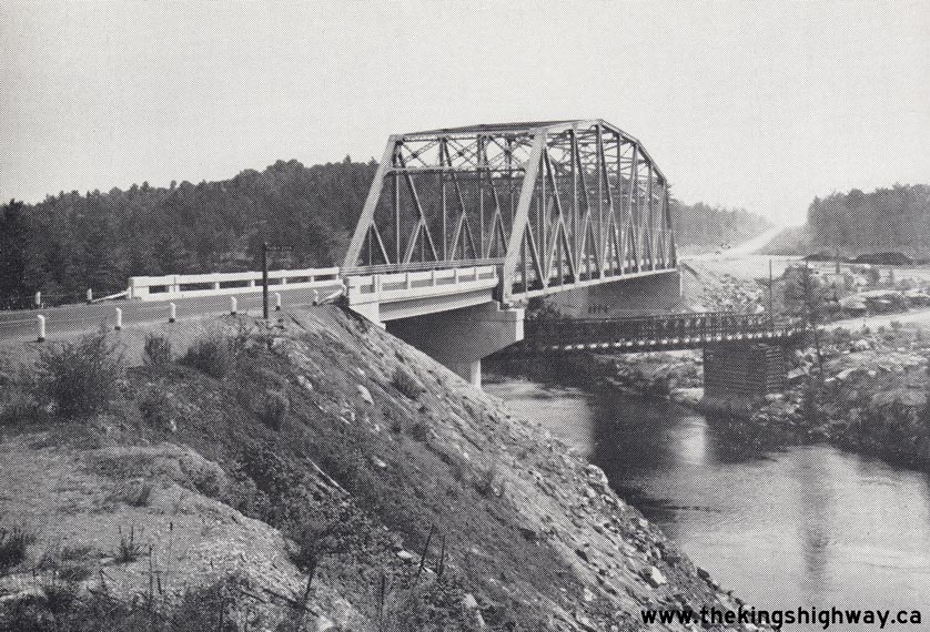
Above - Permanent French River Bridge on Hwy 69 south of Rutter, as seen shortly after completion in 1957. Note the temporary Bailey Bridge below the new
highway bridge, which is the same one seen in the 1954 photo above taken from the opposite side of the French River. The Bailey Bridge was in service carrying Hwy 69
traffic from 1952 up until 1957. It was removed from the site shortly after the new French River Bridge was opened to traffic. Photo taken in 1957. (Photo courtesy of Ontario Ministry of Transportation - © King's Printer for Ontario, 1957) 
Above - Newly-built Hart Bridge on Ontario County Road 21 (Old Hwy 69, today's Simcoe County Road 44), 1/4 mile south of Washago in 1957. This section of
Hwy 69 was bypassed in the early 1950s by a new straighter highway alignment which connected to Hwy 12 at Brechin. The section of Hwy 69 from Brechin to MacTier was
renumbered as Hwy 169 in 1976. Photo taken in 1957. (Photo courtesy of Ontario Ministry of Transportation - © King's Printer for Ontario, 1957) 

Left - Circa 1957 aerial postcard view of the Severn River Bridge on Hwy 11 & Hwy 69 (later Hwy 169) between Washago and Gravenhurst. This three-span steel truss
structure was completed by the DHO in 1931. The bridge was replaced when Hwy 11 was expanded from two to four lanes in 1966. See an
Enlarged Photo Here. (Photo courtesy of the Peterborough Postcard Company) Right - Cleared right-of-way for the revised Hwy 69 (Trans-Canada Highway) alignment near Moose Lake, between Pointe-au-Baril and the Magnetawan River (1958) (Photo courtesy of Ontario Ministry of Transportation - © King's Printer for Ontario, 1958) 

Left - Rock cut and graded right-of-way on the revised alignment of Hwy 69 near Pointe-au-Baril in 1958. Significant sections of the original 1930s alignment
of Hwy 69 in the Pointe-au-Baril area were bypassed by a new Hwy 69 (Trans-Canada Highway) alignment in the 1950s and early 1960s. The original route of Hwy 69
followed today's Shebeshekong Road and Hwy 529. Photo taken in 1958. (Photo courtesy of Ontario Ministry of Transportation - © King's Printer for Ontario, 1958) Right - Replacement of the Shawanaga River Bridge on Hwy 69 between Parry Sound and Pointe-au-Baril in 1959. The original timber through truss bridge across the Shawanaga River was constructed by the Department of Northern Development in 1936. The Parry Sound-Pointe-au-Baril Trunk Road was designated as King's Highway 69 in 1937, after the amalgamation of the Department of Northern Development and the Department of Highways. The new Shawanaga River Bridge at left is still in service on Hwy 69 today. The old abutments of the 1936 timber structure at right are still visible on the eastern side of the present-day Hwy 69. Photo taken in 1959. (Photo courtesy of Ontario Ministry of Transportation - © King's Printer for Ontario, 1959)
Continue on to King's Highway 69: Historical Photos 1960-1979
|
|---|
Links to Adjacent King's Highway Photograph Pages:
Back to King's Highway 68 Photos /
King's Highway 69 History /
On to King's Highway 70 Photos
Ontario Highway History - Main Menu / Back to List of Highways Website contents, photos & text © 2002-2024, Cameron
Bevers (Webmaster) - All Rights Reserved / Contact Me |
|---|