| 
|  |
|
|
This page contains historical and present day photos of Ontario's King's Highway 70A. All photographs displayed on this page
were taken by the Webmaster (Cameron Bevers), unless specifically noted otherwise. Historical photographs are arranged in approximate chronological order, while
present day photographs (Year 2000 to date) are arranged by location from south to north. Click on any thumbnail to see a larger image!
Please note that all photographs displayed on this
website are protected by copyright. These photographs must not be reproduced, published,
electronically stored or copied, distributed, or posted onto other websites without
my written permission. If you want to use photos from this website, please
email me first for permission. Thank-you!
|
|---|
|
Present Day King's Highway 70A Photographs


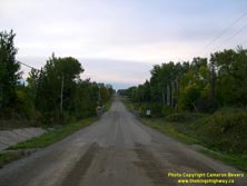
Left - Approaching the Sturgeon Creek Bridge on Former Hwy 70A, facing north towards Black Hawk. See an
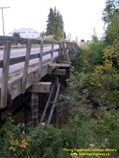
Enlarged Photo here. (Photograph taken on September 2, 2006 - © Cameron Bevers) Right - Eastern side of the Sturgeon Creek Bridge on Former Hwy 70A north of Barwick. This creosoted timber trestle bridge was likely built by the Department of Northern Development around 1936. The Department of Highways took over responsibility for the Barwick Cut-Off Highway from the Department of Northern Development in 1937, at which time the route was officially designated as King's Highway 70A. See an Enlarged Photo here. (Photograph taken on September 2, 2006 - © Cameron Bevers) 
Above - Sturgeon Creek Bridge on Former Hwy 70A between Barwick and Black Hawk. The original timber handrail and curb on the western side of the bridge was
damaged at some point and was repaired. The Rainy River District has many creosoted timber bridges. This construction style is prevalent here since bridges of this
design are fairly simple to construct and require no local source of concrete as a building material. See an
Enlarged Photo here. (Photograph taken on September 2, 2006 - © Cameron Bevers) 

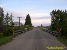
Left - Sturgeon Creek Bridge on Former Hwy 70A, facing north towards Black Hawk. See an
Enlarged Photo here. (Photograph taken on September 2, 2006 - © Cameron Bevers) Right - Facing south along Former Hwy 70A at the Sturgeon Creek Bridge north of Barwick. See an Enlarged Photo here. (Photograph taken on September 2, 2006 - © Cameron Bevers) 

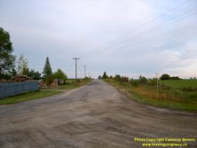
Left - Facing south along Former Hwy 70A south of Black Hawk. This former King's Highway was decommissioned in 1954, following the completion of a new highway
alignment from a point east of Black Hawk to Emo. It's hard to believe that this narrow gravel road used to be a King's Highway, but it was! This road has not changed
much since the province decommissioned Hwy 70A more than 60 years ago. As a result, this road appears more or less the same today as motorists in the 1940s and early
1950s would have experienced it. See an Enlarged Photo here. (Photograph taken on September 2, 2006 - © Cameron Bevers) Right - Former route of Hwy 70A at Black Hawk. From 1937 until the route was decommissioned in 1954, Hwy 70A turned right at this intersection and joined Hwy 70 (today's Hwy 71) 5 km to the east. This east-west section of Hwy 70A later became Hwy 600. The route of Hwy 600 also continues straight ahead along its lengthy and meandering trek to Rainy River. See an Enlarged Photo here. (Photograph taken on September 2, 2006 - © Cameron Bevers) 
Above - Facing east along Hwy 600 (Former Hwy 70A) at Black Hawk. See an
Enlarged Photo here. (Photograph taken on September 2, 2006 - © Cameron Bevers)
More King's Highway 70A Photographs Coming Soon!
|
|---|
Links to Adjacent King's Highway Photograph Pages:
Back to King's Highway 70 Photos /
King's Highway 70A History /
On to King's Highway 71 Photos
Ontario Highway History - Main Menu / Back to List of Highways Website contents, photos & text © 2002-2024, Cameron
Bevers (Webmaster) - All Rights Reserved / Contact Me |
|---|