| 
| |
|
|
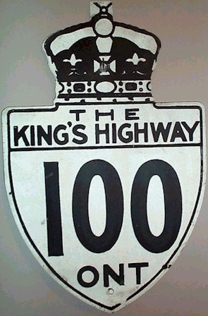
History of King's Highway 100 (#1):
King's Highway 100 was a collector highway in Oxford and Perth Counties, which ran from the Highway 2 Junction in Thamesford to the Highway 7 Junction in St. Marys.
The highway was one of only a handful of King's Highways designated or opened during World War II. In May 1940, a Preliminary Route Plan was prepared which indicated
the Ontario Department of Highways' intention to assume the existing Thamsford-St. Marys Road as a new King's Highway. The highway was acquired and designated as
Highway 100 on January 15, 1941. This route was the first provincial highway in Ontario to be assigned a three-digit route number. Initially, the highway was
gravel-surfaced from end-to-end. In 1960, a portion of Highway 100 was paved from Thamesford to Kintore. In 1962, a major route renumbering took place in the
Woodstock and St. Marys area, which resulted in the entire route of Highway 100 being re-designated as
Highway 19. A different, unrelated Highway 100
existed near London from 1977 until 1993. 
 |
|---|
Links to Adjacent King's Highway Pages: 


Website contents, photos & text © 2002-2024, Cameron
Bevers (Webmaster) - All Rights Reserved / Contact Me |
|---|