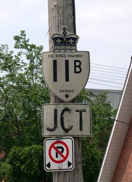
History of King's Highway 11B (Holland Landing):
The Holland Landing Highway 11B Business Route was created in 1958, when a new Highway 11 Bypass was completed and opened to traffic. The new four-lane divided
highway diversion carried long-distance through traffic away from the existing Highway 11 at the top of the Holland Landing Hill and tied back into the existing route
of Highway 11 just south of Bradford. The new highway bypassed the community of Holland Landing entirely. After the Highway 11 Bypass opened, the old route of Highway 11 through
Holland Landing became Highway 11B. The business route was marked on the Ontario Official Road Maps up until 1971. However, Highway 11B apparently continued to be
signed as such through Holland Landing up until 1981, when the route was finally decommissioned as a King's Highway. The province transferred Highway 11B to the
Regional Municipality of York, effective December 23, 1981. The route of Highway 11B through Holland Landing is now known as York Regional Road 83.

|