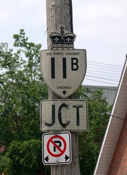
History of King's Highway 11B (Huntsville):
The Huntsville Highway 11B Business Route was created after a new Highway 11 Bypass was completed across Lake Vernon Narrows in 1959, which completely bypassed the
downtown area. The new Huntsville Bypass was officially opened to traffic on November 27, 1959. The old route of Highway 11 through Downtown Huntsville became
Highway 11B. The route through the Town of Huntsville was designated as a Municipal Connecting Link by an Order-in-Council on October 9, 1958, while the route was
still known as Highway 11. Highway 11B was 11.4 km in length, including the sections under municipal jurisdiction. The highway lasted until 1972, when it was formally
decommissioned. Highway 11B was transferred from the province to the District Municipality of Muskoka, effective April 30, 1972. This highway is now known as Muskoka
Road 3.

|