| 
| |
|
|
History of King's Highway 131 (#2):
The second King's Highway 131 was a short collector highway which connected Highway 27 to Highway 90 near Barrie in the 1980s and 1990s. Highway 131 first came into
existence in 1984. A Preliminary Assumption Plan was prepared by the Ministry of Transportation and Communications on November 30, 1983, indicating the
Ministry's intentions to assume existing Simcoe County Road 31 between Highway 27 and Highway 90 near Barrie as a new King's Highway. The plan was registered on
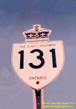
February 20, 1984, and the route was formally designated as King's Highway 131 by an Order-in-Council, effective March 29, 1984. Highway 131 was 6.7 km in length. It
formed a portion of a signed alternate route from Highway 400 near Thornton to Highway 26 near Minesing. This signed alternate route was established in an attempt to
alleviate traffic congestion through Barrie on Bayfield Street (Highway 26), by encouraging some Wasaga Beach-bound traffic to exit Highway 400 before reaching
Barrie. Highway 131 was retained in the King's Highway system until January 1, 1998, when it was downloaded to the County of Simcoe. The route is now known as Simcoe
County Road 27. Reportedly, the route of Highway 131 was also temporarily signed with Highway 27 route markers during 1997. The old route of Highway 27 via Essa Road from the Highway 131 Junction northerly to the Barrie City Limits was transferred to the County of Simcoe on March 31, 1997. In order to restore route continuity with the north leg of Highway 27 between Barrie and Waverley, Highway 27 was temporarily signed via Highway 131, Highway 90 and Highway 400. This temporary route was discontinued on January 1, 1998, when the entire route of Highway 27 was downloaded by the province. A different, unrelated Highway 131 existed in Thunder Bay in the 1970s. 
 |
|---|
Additional Information About King's Highway 131 (#2):
King's Highway 131 (#2) - Route Information (At Scott Steeves' website: asphaltplanet.ca)
|
|---|
Links to Adjacent King's Highway Pages: 


Website contents, photos & text © 2002-2024, Cameron
Bevers (Webmaster) - All Rights Reserved / Contact Me |
|---|